A broch is an Iron Age drystone hollow-walled structure found in Scotland. Brochs belong to the classification "complex Atlantic roundhouse" devised by Scottish archaeologists in the 1980s. Their origin is a matter of some controversy.

Isle of Whithorn is one of the most southerly villages and seaports in Scotland, lying on the coast north east of Burrow Head, about three miles from Whithorn and about thirteen miles south of Wigtown in Dumfries and Galloway. Whithorn,, is a former royal burgh in Wigtownshire, Dumfries and Galloway, with which the Isle of Whithorn is frequently incorrectly amalgamated or confused. It is referred to locally as 'The Isle' - never 'the Isle of Whithorn'.
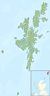
Yell is one of the North Isles of Shetland, Scotland. In the 2011 census it had a usually resident population of 966. It is the second largest island in Shetland after the Mainland with an area of 82 square miles (212 km2), and is the third most populous in the archipelago, after the Mainland and Whalsay.

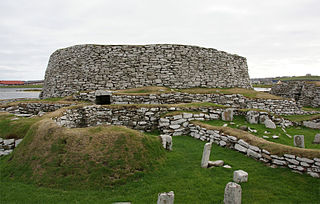
Broch of Mousa is a preserved Iron Age broch or round tower. It is on the island of Mousa in Shetland, Scotland. It is the tallest broch still standing and amongst the best-preserved prehistoric buildings in Europe. It is thought to have been constructed c. 100 BC, and is one of more than 500 brochs built in Scotland. The site is managed by Historic Environment Scotland as a scheduled monument.
The Broch of Clickimin is a large, well-preserved but restored broch in Lerwick in Shetland, Scotland. Originally built on an island in Clickimin Loch, it was approached by a stone causeway. The broch is situated within a walled enclosure and, unusually for brochs, features a large "forework" or "blockhouse" between the opening in the enclosure and the broch itself. The site is maintained by Historic Scotland. According to its excavator, John R.C. Hamilton, there were several periods of occupation of the site: Late Bronze Age farmstead, Early Iron Age farmstead, Iron Age fort, broch period, and wheelhouse settlement.

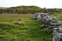
Ullinish is a crofting township on Loch Bracadale, on the southwest coast of Skye, Scotland. The only promontory fort on Skye is located at Ullinish. It is situated to the west of Struan and just south of the hamlet of Ebost. Historically, Ullinish is associated with the MacLeod family. Of literary note, Samuel Johnson's views and denunciation of James Macpherson's Ossian were confirmed while Johnson was in Ullinish.
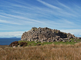
Dun Carloway is a broch situated in the district of Carloway, on the west coast of the Isle of Lewis, Scotland. It is a remarkably well preserved broch - on the east side parts of the old wall still reach to 9 metres tall.

Esha Ness, also spelled Eshaness, is a peninsula on the west coast of Northmavine, on the island of Mainland, Shetland, Scotland. Esha Ness Lighthouse on the west coast, just south of Calder's Geo. It was designed by David Alan Stevenson and commissioned in 1929. The hamlet of Tangwick contains the Tangwick Haa Museum, which opened in the former Laird's house in 1987.

Burroughston Broch is an Iron Age broch located on the island of Shapinsay in the Orkney Islands, in Scotland. The site overlooks the North Sea on the northeast part of Shapinsay. Excavated in the mid 19th century, Burroughston Broch is still well-preserved. The drystone walls are up to four metres thick in some parts and there is a complete chamber intact off the entrance passage. Some remains of stone fittings are evident in the interior.

Dun Ringill is an Iron Age hill fort on the Strathaird peninsula on the island of Skye, Scotland. Further fortified in the Middle Ages, tradition holds that it was for several centuries the seat of Clan MacKinnon. It is located east of Kirkibost on the west shore of Loch Slapin.

Huxter Fort is an iron age fortification on the island of Whalsay, in the Shetland islands of Scotland, dating to around 300 BC. It is on an islet in the Loch of Huxter, connected to the shore by a causeway.

Crosskirk Broch was a fortification near the present day hamlet of Crosskirk near Thurso, Caithness, Scotland. After thorough archaeological exploration it was destroyed in 1972 since the site had become unsafe due to sea erosion. The site was unusual in having a broch, a large circular fortification, built within an older promontory fortification with a ring wall and blockhouse.

Dun an Sticir is an Iron Age broch situated approximately 9.5 kilometers north of Lochmaddy in a lake on North Uist in the Scottish Outer Hebrides. A building was erected on the site in the late medieval period.

The Broch of Borwick is an Iron Age broch located on Mainland, Orkney, Scotland. It is a scheduled monument.

Dun Ardtreck is a D-shaped dun, or "semi-broch", located on the west coast of the island of Skye, in Scotland.
Dun Borrafiach is an Iron Age broch located on the north coast of the island of Skye, in Scotland.

Dun Hallin is an Iron Age broch located near the northwest coast of the island of Skye, in Scotland.

Broch of Inshlampie is an Iron Age broch in Scotland.

Loch Na Berie is a broch in the Outer Hebrides of Scotland, located approximately 400 yards from the shore, and is thought to have been located on an island as the land to the east is a marsh. The site is designated a Scheduled Monument.