Howard County is located in the U.S. state of Maryland. As of the 2020 census, the population was 334,529. Since there are no incorporated municipalities, there is no incorporated county seat either. Therefore, its county seat is the unincorporated community of Ellicott City. Howard County is included in the Baltimore-Columbia-Towson, MD Metropolitan Statistical Area, which is part of the larger Washington–Baltimore combined statistical area.

Elkridge is an unincorporated community and census-designated place (CDP) in Howard County, Maryland, United States. The population was 15,593 at the 2010 census. Founded early in the 18th century, Elkridge is adjacent to two other counties, Anne Arundel and Baltimore.

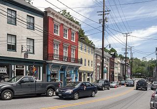
Ellicott City is an unincorporated community and census-designated place in, and the county seat of, Howard County, Maryland, United States. Part of the Baltimore metropolitan area, its population was 75,947 at the 2020 census, making it the most populous unincorporated county seat in the country.

The Patuxent River is a tributary of the Chesapeake Bay in the state of Maryland. There are three main river drainages for central Maryland: the Potomac River to the west passing through Washington, D.C., the Patapsco River to the northeast passing through Baltimore, and the Patuxent River between the two. The 908-square-mile (2,352 km2) Patuxent watershed had a rapidly growing population of 590,769 in 2000. It is the largest and longest river entirely within Maryland, and its watershed is the largest completely within the state.

The Patapsco River mainstem is a 39-mile (63 km) river in central Maryland that flows into the Chesapeake Bay. The river's tidal portion forms the harbor for the city of Baltimore. With its South Branch, the Patapsco forms the northern border of Howard County, Maryland. The name "Patapsco" is derived from the Algonquian pota-psk-ut, which translates to "backwater" or "tide covered with froth."

The Battle of Bladensburg, also known as the Bladensburg Races, was a battle of the Chesapeake Campaign during the War of 1812, fought on 24 August 1814, at Bladensburg, Maryland, 8.6 miles (13.8 km) northeast of Washington, D.C.
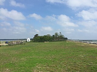
Point Lookout State Park is a public recreation area and historic preserve occupying Point Lookout, the southernmost tip of a peninsula formed by the confluence of Chesapeake Bay and the Potomac River in St. Mary's County, Maryland. The state park preserves the site of an American Civil War prisoner of war camp and the Point Lookout Light, which was built in 1830. It is the southernmost spot on Maryland's western shore, the coastal region on the western side of the Chesapeake Bay.

Maryland Route 175 is a state highway in the U.S. state of Maryland. The highway runs 17.01 miles (27.37 km) from Little Patuxent Parkway in Columbia east to MD 3 in Millersville. MD 175 is a major highway through the large unincorporated community of Columbia; the highway connects U.S. Route 29 next to Columbia Town Center with Interstate 95 (I-95) and an industrial area on the eastern side of Howard County. MD 175 also connects Fort Meade with Jessup and Odenton in western Anne Arundel County, where it links MD 295 and MD 32 with the eastern part of the U.S. Army base.

Maryland Route 198 is a state highway in the U.S. state of Maryland. The highway runs 14.14 miles (22.76 km) from MD 650 near Spencerville east to the entrance of Fort George G. Meade beyond its junction with MD 32. MD 198 connects Laurel in far northern Prince George's County with the northeastern Montgomery County communities of Spencerville and Burtonsville and Maryland City and Fort Meade in western Anne Arundel County. The highway is a four-to-six-lane divided highway between U.S. Route 29 in Burtonsville and the Baltimore–Washington Parkway in Maryland City.

Maryland Route 108 is a state highway in the U.S. state of Maryland. The highway runs 34.23 miles (55.09 km) from MD 27 in Damascus east to MD 175 in Columbia. MD 108 is an S-shaped highway that winds through northern Montgomery County and central Howard County. The highway connects the Montgomery County communities of Laytonsville, Olney, Sandy Spring, and Ashton with the Howard County villages of Highland and Clarksville. MD 108 serves as the northern edge of Columbia and connects several of the planned community's suburban villages.
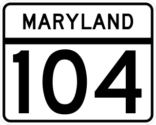
Maryland Route 104 is a state highway in the U.S. state of Maryland. Known as Waterloo Road, the state highway runs 1.14 miles (1.83 km) from MD 108 in Columbia north to MD 103 in Ellicott City. MD 104 connects MD 108, MD 103, and MD 100 in northeastern Howard County. The state highway was originally constructed as MD 531 in the early 1930s and became part of MD 175 in the mid-1940s. After MD 175 was rerouted through Columbia in the late 1970s, MD 104 was assigned to its present course.
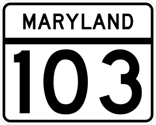
Maryland Route 103 is a state highway in the U.S. state of Maryland. The state highway runs 8.29 miles (13.34 km) from St. Johns Lane in Ellicott City east to Parkway Drive South in Hanover. MD 103 serves as the local complement to MD 100 from Ellicott City in northeastern Howard County through Dorsey to Hanover in northwestern Anne Arundel County. The state highway was constructed from U.S. Route 1 in Elkridge to US 29 in Ellicott City in the 1920s. MD 103's eastern terminus was relocated from Elkridge to US 1 near Dorsey in 1956. When MD 100 was constructed between Glen Burnie and Ellicott City in the 1990s, the state highway was extended to its present western and eastern termini. MD 103 replaced MD 176 from US 1 east to near MD 295.

Maryland Route 99 is a state highway in the U.S. state of Maryland. Known as Old Frederick Road, the state highway runs 7.57 miles (12.18 km) from MD 32 near West Friendship east to U.S. Route 29 in Ellicott City. MD 99 parallels the north side of Interstate 70 (I-70) through a rural and suburban area in northeastern Howard County. MD 99, which follows the original 18th-century road west from Baltimore, was constructed as part of three state highways: MD 99, the original MD 100, and MD 105. All three highways were constructed between the early 1920s and early 1930s. MD 99 originally turned south along St. Johns Lane to US 40 and MD 144; in 1956, the state highway was rerouted along part of MD 100 and all of MD 105 to downtown Ellicott City. MD 99's eastern terminus was rolled back to US 29 in two steps in the late 1970s and late 1980s.

Maryland Route 216 is a state highway in the U.S. state of Maryland. Known for most of its length as Scaggsville Road, the highway runs 8.73 miles (14.05 km) from MD 108 at Highland east to MD 198 in Laurel. MD 216 connects Highland, Fulton, Scaggsville, and North Laurel in southern Howard County with Laurel in far northern Prince George's County. The highway connects those communities with Interstate 95 (I-95) and U.S. Route 29.
Scaggsville is an unincorporated community and census-designated place in Howard County, Maryland, United States. It is situated near the southeastern tip of Howard County, between Laurel and Fulton. As of the 2010 census it had a population of 24,333. The town mainly consists of residences, with some commercial establishments. Scaggsville generally falls within ZIP code 20723, assigned to Laurel, though the town formerly had its own post office.

Maryland Route 231 (MD 231) is a state highway in the U.S. state of Maryland. The state highway runs 16.39 miles (26.38 km) from Olivers Shop Road near Hughesville east to MD 765 in Prince Frederick. MD 231 crosses the Patuxent River on the Benedict Bridge, which connects Benedict in eastern Charles County with Hallowing Point in central Calvert County. The highway directly connects MD 5 in Hughesville with MD 2/MD 4 in Prince Frederick. MD 231 was constructed from Hughesville to Benedict and from Hollowing Point to Prince Frederick in the early 1920s. The portion of the state highway west of Hughesville was built in the early 1930s, about the same time ferry service began between Benedict and Hallowing Point. The Benedict Bridge was started in 1950 and was completed in 1952; the bridge remained the southernmost crossing of the Patuxent River for 25 years. The bridge was tolled from its opening until around 1955. MD 231 was reconstructed between Hughesville and Prince Frederick in the mid- to late 1950s to better serve intercounty traffic.
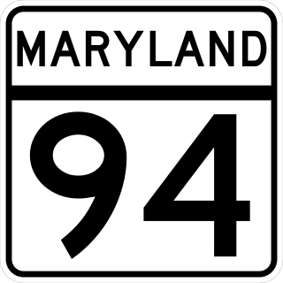
Maryland Route 94 is a state highway in the U.S. state of Maryland. Known as Woodbine Road, the state highway runs 6.25 miles (10.06 km) from the Montgomery–Howard county line at the Patuxent River north to Old Frederick Road near Lisbon. MD 94 originally extended into southern Carroll County in addition to connecting the western Howard County communities of Lisbon and Florence. The state highway was constructed from Lisbon to Woodbine in the late 1910s. MD 94 was constructed from Lisbon south through Florence and from Woodbine north to the village of Daniel south of MD 26 in the late 1920s and early 1930s. The state highway was extended south and removed from the state highway system north of Lisbon in 1956. MD 94 was relocated when its interchange with Interstate 70 (I-70)/U.S. Route 40 was built in the mid-1970s. The state highway has two roundabouts, one of which was the first modern roundabout in Maryland.

Whiskey Bottom Road is a historic road north of Laurel, Maryland that traverses Anne Arundel and Howard Counties in an area that was first settled by English colonists in the mid-1600s. The road was named in the 1880s in association with one of its residents delivering whiskey after a prohibition vote. With increased residential development after World War II, it was designated a collector road in the 1960s; a community center and park are among the most recent roadside developments.

The Ellicott City Granodiorite is a Silurian or Ordovician granitic pluton in Howard and Baltimore Counties, Maryland. It is described as a biotite granodiorite along the margin of the intrusion which grades into a quartz monzonite in its core. It intrudes through the Wissahickon Formation and the Baltimore Gabbro Complex.

The Patapsco Valley is a small valley surrounding the Patapsco River in central Maryland. The region is known for its historical significance as a major economic and industrial center in the eighteenth and nineteenth centuries.
