Sottomarina

Last updated
Sottomarina
Dsc 1172 Sottomarina.jpg
Aerial view
Italy provincial location map 2016.svg
Red pog.svg
Sottomarina
Location of Sottomarina in Italy
Coordinates: 45°12′53″N12°17′41″E / 45.21472°N 12.29472°E / 45.21472; 12.29472
CountryFlag of Italy.svg  Italy
Region Flag of Veneto.svg  Veneto
Province Venice (VE)
Comune Chioggia
Elevation
2 m (7 ft)
Demonym Marinanti
Time zone UTC+1 (CET)
  Summer (DST) UTC+2 (CEST)
Postal code
30015
Dialing code 041

Sottomarina is a small town on a peninsula which has the same name. It is a frazione of the comune of Chioggia, which is part of the Metropolitan City of Venice in the Veneto region in north-eastern Italy.

Contents

Geography

Sottomarina is a peninsula which protrudes into the Lagoon of Venice, forming its southern coastal tract. The other parts of the coastline of this lagoon are the barrier islands of Pellestrina and Lido, in the middle, and the peninsula of Cavallino in the north. Sottomarina is separated form Pellestrina by the Chioggia inlet. The lagoon side of its coast is by the islands which form the town of Chioggia and on the eastern side of the Val di Brenta, southernmost basin of the lagoon. It southern end is cut through by the mouth of the River Brenta. The peninsula is narrow at the northern end as it widens and it progress southwards. The town is close to Chioggia and it is connected with it by a 700 m bridge.

History

The main settlement in Sottomarina was known as Clodia Minor in the 7th century AD. This distinguished it form Clodia Major, which is now the town of Chioggia. These Latin names then morphed into Chioggia Minore and Chioggia Maggiore. The settlement was governed by its own tribune and issued its own laws. It was connected to Chioggia by a stone bridge. It had the churches of San Martino, Sant'Antonio Abate, San Matteo, a hospital and a castle with a tower on an islet named after it (Buoncastello), just off the northeastern corner of the peninsula. [1]

The town was destroyed in 1379, during the War of Chioggia between the Republics of Genoa and Venice. The senate of the Republic of Venice forbade its rebuilding until the second half 17th century. During that period it was uninhabited and subject to floods. In the 18th century, the murazzi, the imposing Istrian stone bank was built to protect Sottomarina from storm surges. [1]

At the southern end of Sottomarina there is the hamlet of Brondolo. The doge Teodato Ipato (742-55) had a fort built at Brondolo to protect the southern end of the Duchy of Venice. [2]

There used to be a small lagoon, the lagoon of Brondolo, south of the Lagoon of Venice and close to Brondolo, to its southeast. The two lagoons were connected by the Brondolo inlet. The Republic of Venice carried out a number of southwards diversions of the river Brenta, which was causing silting in the central area of the Lagoon of Venice. In one of these it was taken to flow into another part of the lagoon, in the Val di Brenta basin, on its shore opposite Chioggia, with the creation of a canal called Brenta Nova, which was completed in 1507. Then the Venetians built the Parador di Brondolo, an embankment, to cut this river off the Lagoon of Venice and to separate this lagoon form the Lagoon of Brondolo. It was taken to the Brondolo inlet and made to flow into the latter lagoon. This was completed in 1577. Since this lagoon was closed off from the sea, it was turned into a freshwater coastal lake in a couple of centuries due to the river bringing in freshwater. Later this lagoon silted as the river brought in its sediments. [3]

The last diversion of the Brenta occurred in the 1930s with the construction of an embankment to take this river to the sea. This was done to prevent further silting, to safeguard the local flora and fauna, which were being compromised, and to prevent malaria. Since then, the southern side of the coast of Sottomarina has been widening at an average rate of three metres a year due to the sediments brought to the shore by the river. [1]

Economy

Traditionally the inhabitants of this peninsula were farmers, while those of Chioggia were fishermen. Today Sottomarina is primarily a busy seaside resort, thanks to its proximity to Venice, Padua, Vicenza, Verona and Rovigo. The first beach resorts, together with an over 2 km long promenade, were built in 1900-1903. [4] The sandy beach is 5 1/2 km long and reaches a width of 300 metres in some places. [1]

See also

Related Research Articles

<span class="mw-page-title-main">Geography of Italy</span> Geographical features of Italy

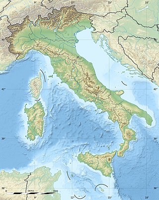
The geography of Italy includes the description of all the physical geographical elements of Italy. Italy, whose territory largely coincides with the homonymous geographical region, is located in southern Europe and comprises the long, boot-shaped Italian Peninsula crossed by the Apennines, the southern side of Alps, the large plain of the Po Valley and some islands including Sicily and Sardinia. Italy is part of the Northern Hemisphere. Two of the Pelagie Islands are located on the African continent.

<span class="mw-page-title-main">Venetian Lagoon</span> Enclosed bay in which the city of Venice is situated

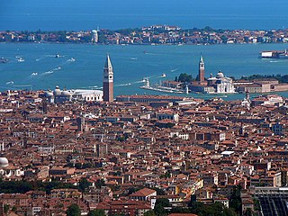
The Venetian Lagoon is an enclosed bay of the Adriatic Sea, in northern Italy, in which the city of Venice is situated. Its name in the Italian and Venetian languages, Laguna Veneta—cognate of Latin lacus, "lake"—has provided the English name for an enclosed, shallow embayment of salt water, a lagoon.

<span class="mw-page-title-main">Venice Lido</span> Barrier island in the Venetian Lagoon

The Lido, or Venice Lido, is an 11-kilometre-long (7-mile) barrier island in the Venetian Lagoon, Northern Italy; it is home to about 20,400 residents. The Venice Film Festival takes place at the Lido late August/early September.

<span class="mw-page-title-main">Brenta (river)</span> River in Italy

The Brenta is an Italian river that runs from Trentino to the Adriatic Sea just south of the Venetian lagoon in the Veneto region, in the north-east of Italy.

<span class="mw-page-title-main">Pellestrina</span> Island in northern Italy

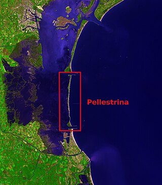
Pellestrina is an island in northern Italy, forming a barrier between the southern Venetian Lagoon and the Adriatic Sea, lying south west of the Lido.

<span class="mw-page-title-main">Chioggia</span> Comune in Veneto, Italy

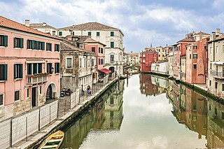
Chioggia is a coastal town and comune of the Metropolitan City of Venice in the Veneto region of northern Italy.

<span class="mw-page-title-main">Gulf of Venice</span>

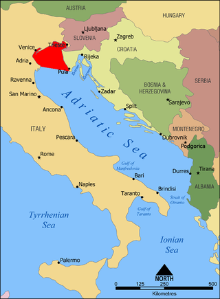
The Gulf of Venice is an informally recognized gulf of the Adriatic Sea. It lies at the extreme north end of the Adriatic, limited on the southwest by the easternmost point of the Po Delta in Italy and on the southeast by the southernmost point of the Istrian Peninsula in Croatia. It is bordered by the coastlines of northeastern Italy and southwestern Croatia and Slovenia.

<span class="mw-page-title-main">MOSE</span> Mobile floodgate system in Venice, Italy

MOSE is a project intended to protect the city of Venice, Italy, and the Venetian Lagoon from flooding.

<span class="mw-page-title-main">War of Chioggia</span> Conflict between Venice and Genoa from 1378 to 1381

The War of Chioggia was a conflict fought by the Republic of Genoa against the Republic of Venice between 1378 and 1381, the conclusion of an open confrontation that had lasted for years and which had already included some occasional and limited military clashes.

<span class="mw-page-title-main">Agnello Participazio</span> Doge of the Republic of Venice from 811 to 827

Agnello Participazio was the tenth traditional and eighth (historical) doge of the Duchy of Venetia from 811 to 827. He was born to a rich merchant family from Heraclea and was one of the earliest settlers in the Rivoalto group of islands. His family had provided a number of tribuni militum of Rivoalto. He owned property near the Church of Santi Apostoli. A building in the nearby Campiello del Cason was the residence of the tribunes. Agnello was married to the dogaressa Elena.

<span class="mw-page-title-main">Actv</span>

Actv S.p.A. is a public company responsible for public transportation in Venice and Chioggia municipalities and for interurban bus services in province of Venice. ACTV is not responsible for Venice People Mover or waterbus routes between airport and the lagoon area. Connections by bus with Venice airport are managed by ACTV and by ATVO.

<span class="mw-page-title-main">Dolo</span> Comune in Veneto, Italy

Dolo is a town and comune in the Metropolitan City of Venice, Veneto, Italy. It is connected by the SP26 provincial road and is one of the towns of the Riviera del Brenta.

<span class="mw-page-title-main">Cavarzere</span> Comune in Veneto, Italy

Cavarzere is a comune (municipality) in the Metropolitan City of Venice in the Italian region of Veneto, located about 35 kilometres southwest of Venice.

The Via Annia was the Roman road in Venetia in north-eastern Italy. It run on the low plains of the lower River Po and of the lower Veneto and Friuli-Venezia Giulia regions, an area which had many rivers and large marsh areas and bordered the coastal lagoons. It linked Atria to Aquileia, passing through Patavium. Then it got to the mainland coast of the Lagoon of Venice near today's Mestre and passed through Altinum. After this, it went through Iulia Concordia, which was further inland. It was paved only through the main towns. The rest was gravelled. It was six to eighteen metre wide. It played an important part in the Romanization of the region.

<span class="mw-page-title-main">Giovanni Dolfin</span> Doge of Venice from 1356 to 1361

Giovanni Dolfin, also known as Giovanni Delfino or Delfin, was the 57th Doge of Venice from his appointment on 13 August 1356 to his death in 1361. Despite his value as a general, during his reign Venice lost Dalmatia. He was blinded in one eye after a wound received in battle.

<span class="mw-page-title-main">Malamocco</span> Human settlement in Italy

Malamocco was the first, and for a long time, the only, settlement on the Lido of Venice barrier island of the Lagoon of Venice. It is located just south of the island's center and it is part of the Lido-Pellestrina borough of the municipality of Venice.

Luigi Steffani (1828–1898) was an Italian painter, mainly of sea and landscapes.

<span class="mw-page-title-main">Metropolitan City of Venice</span> Metropolitan city in Veneto, Italy

The Metropolitan City of Venice is a metropolitan city in the Veneto region of Italy, one of ten metropolitan cities in Italy. Its capital is the city of Venice. It replaced the province of Venice in 2015 and includes the city of Venice and 43 comuni. It was first created by the reform of local authorities and then established by Law 56/2014. The Metropolitan City of Venice is headed by the Metropolitan Mayor and the Metropolitan Council. Since 15 June 2015, as the new mayor of the capital city, Luigi Brugnaro is the first mayor of the metropolitan city.

Tegnue are rock formations which have developed in the sea bottom of the Gulf of Venice, in the northern Adriatic Sea. They are bio-sediments which are very similar to coral reefs and for this reason they also are called Adriatic coral reefs. They are found especially off the coasts of Caorle, the Cavallino peninsula, the Lido di Venezia island and the Sottomarina peninsula at Chioggia. There are eight such formations. They are at a depth of -15/-40 m. The largest formation is off the coast of the Cavallino peninsula.

Gronda lagunare is a term used to indicate the area of the Lagoon of Venice by its mainland shore. The term is derived from the fact that it receives the waters from the rivers and streams which flow into the lagoon from the drainage basin of the plain of the mainland by the lagoon. It is also reached by the tidal flows form he sea., it is meant to be a belt that forms a transition area between the open lagoon and the mainland.

References

  1. 1 2 3 4 Portale ufficiale di Chioggia, Sottomarina e Isola Verde
  2. deusdedit_(Dizionario-Biografico) Ortalli G. – DEUSDEDIT, Dizionario Biografico degli Italiani - Volume 39 (1991)
  3. Bondesan A,. Furlanetto P, Artificial fluvial diversions in the mainland of the Lagoon of Venice during the 16th and 17th centuries inferred by historical cartography analysis, Geomphologie, vol. 18, n° 2, 2012. p.14
  4. "Quatro Ciàcoe - I primi stabilimenti balneari a Sotomarina - Lujo-Agosto 2016 - a cura de Angelo Padoan".