
The Amu Darya, also called the Amu, the Amo, and historically the Oxus, is a major river in Central Asia and Afghanistan. Rising in the Pamir Mountains, north of the Hindu Kush, the Amu Darya is formed by the confluence of the Vakhsh and Panj rivers, in the Tigrovaya Balka Nature Reserve on the border between Afghanistan and Tajikistan, and flows from there north-westwards into the southern remnants of the Aral Sea. In its upper course, the river forms part of Afghanistan's northern border with Tajikistan, Uzbekistan, and Turkmenistan. In ancient history, the river was regarded as the boundary of Greater Iran with Turan, which roughly corresponded to present-day Central Asia. The Amu Darya has a flow of about 70 cubic kilometres per year on average.

Kazakhstan is located in Central Asia. With an area of about 2,724,900 square kilometers (1,052,100 sq mi) Kazakhstan is more than twice the combined size of the other four Central Asian states and 60% larger than Alaska. The country borders Turkmenistan, Uzbekistan, and Kyrgyzstan to the south; Russia to the north; Russia and the Caspian Sea to the west; and China's Xinjiang Uygur Autonomous Region to the east.
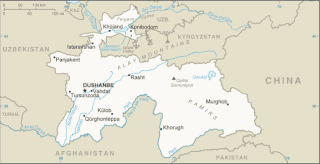
Tajikistan is nestled between Kyrgyzstan and Uzbekistan to the north and west, China to the east, and Afghanistan to the south. Mountains cover 93 percent of Tajikistan's surface area. The two principal ranges, the Pamir Mountains and the Alay Mountains, give rise to many glacier-fed streams and rivers, which have been used to irrigate farmlands since ancient times. Central Asia's other major mountain range, the Tian Shan, skirts northern Tajikistan. Mountainous terrain separates Tajikistan's two population centers, which are in the lowlands of the southern and northern sections of the country. Especially in areas of intensive agricultural and industrial activity, the Soviet Union's natural resource utilization policies left independent Tajikistan with a legacy of environmental problems.
Turkmenistan is a landlocked country in Central Asia, bordering the Caspian Sea to the west, Iran and Afghanistan to the south, Uzbekistan to the north-east, and Kazakhstan to the north-west. It is the southernmost republic of the Commonwealth of Independent States (CIS), the loose federation created at the end of 1991 by most of the Post-Soviet states.
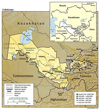
Uzbekistan is a country in Central Asia, located north of Turkmenistan and Afghanistan. With an area of 447,000 square kilometers, Uzbekistan stretches 1,425 km (885 mi) from west to east and 930 km (580 mi) from north to south. It borders Turkmenistan to the southwest, Kazakhstan to the north and Tajikistan and Kyrgyzstan to the south and east. Uzbekistan also has four small exclaves in Turkmenistan.

The Aral Sea was an endorheic lake lying between Kazakhstan to its north and Uzbekistan to its south which began shrinking in the 1960s and largely dried up by the 2010s. It was in the Aktobe and Kyzylorda regions of Kazakhstan and the Karakalpakstan autonomous region of Uzbekistan. The name roughly translates from Mongolic and Turkic languages to "Sea of Islands", a reference to the large number of islands that once dotted its waters. The Aral Sea drainage basin encompasses Uzbekistan and parts of Afghanistan, Iran, Kazakhstan, Kyrgyzstan, Tajikistan, and Turkmenistan.

The Karakum Desert, also spelled Kara-Kum and Gara-Gum, is a desert in Central Asia. The name refers to the shale-rich sand beneath the surface. It occupies about 70 percent, or roughly 350,000 km2 (140,000 sq mi), of Turkmenistan.

An endorheic basin is a drainage basin that normally retains water and allows no outflow to other, external bodies of water ; instead, the water drainage flows into permanent and seasonal lakes and swamps that equilibrate through evaporation. Endorheic basins also are called closed basins, terminal basins, and internal drainage systems.

Lake Balkhash is a lake in southeastern Kazakhstan, one of the largest lakes in Asia and the 15th largest in the world. It is located in the eastern part of Central Asia and sits in the Balkhash-Alakol Basin, an endorheic (closed) basin. The basin drains seven rivers, the primary of which is the Ili, bringing most of the riparian inflow; others, such as the Karatal, bring surface and subsurface flow. The Ili is fed by precipitation, largely vernal snowmelt, from the mountains of China's Xinjiang region.

A salt lake or saline lake is a landlocked body of water that has a concentration of salts and other dissolved minerals significantly higher than most lakes. In some cases, salt lakes have a higher concentration of salt than sea water; such lakes can also be termed hypersaline lakes, and may also be pink lakes on account of their colour. An alkalic salt lake that has a high content of carbonate is sometimes termed a soda lake.

Moynaq, also spelled as Muynak, is a city in northern Karakalpakstan, an autonomous republic in Uzbekistan. It is the seat of the Moynaq district. Formerly a sea port on the Aral Sea, it is now 150 km from the water in the Aralkum Desert and thus is a disaster tourism destination. It is also the location for the biggest electronic music festival in Central Asia.
The Messinian salinity crisis was a geological event during which the Mediterranean Sea went into a cycle of partial or nearly complete desiccation (drying-up) throughout the latter part of the Messinian age of the Miocene epoch, from 5.96 to 5.33 Ma. It ended with the Zanclean flood, when the Atlantic reclaimed the basin.

The North Aral Sea is the portion of the former Aral Sea that is fed by the Syr Darya River. It split from the South Aral Sea in 1987–1988 as water levels dropped due to river diversion for agriculture.

The Sarygamysh Lake, also Sarykamysh or Sary-Kamysh, is a lake in Central Asia. It is about midway between the Caspian Sea and the Aral Sea. It is the largest lake in Turkmenistan, in which three quarters of the entire lake's area is located. The Sarykamysh basin and the Sarykamysh delta of the Amu Darya river are physical and geographical nature regions of the Dashoguz Region of Turkmenistan.

The Aydar Lake is part of the man-made Aydar-Arnasay system of lakes, which covers 4,000 square kilometres (1,500 mi2). This has 3 brackish water lakes, deep basins of the south-eastern Kyzyl Kum. The lakes are expansive reservoirs of Soviet planning.

Kamyslybas is a large saltwater lake in the Kyzylorda Region, Kazakhstan. It has an area of 176 km2, although the water level in the lake often fluctuates.
Environmental issues in Turkmenistan are most visible in three significant areas: desertification, the drying of the Aral Sea, and chemical pollution. All three of these areas are directly linked to agricultural practices in the country.

The Uzboy was a distributary of the Amu Darya which flowed through the northwestern part of the Karakum Desert of Turkmenistan until the 17th century, when it abruptly dried up, eliminating the agricultural population that had thrived along its banks..

An endorheic lake is a collection of water within an endorheic basin, or sink, with no evident outlet. Endorheic lakes are generally saline as a result of being unable to get rid of solutes left in the lake by evaporation. These lakes can be used as indicators of anthropogenic change, such as irrigation or climate change, in the areas surrounding them. Lakes with subsurface drainage are considered cryptorheic.

The Central Asian riparian woodlands ecoregion is spread out across the deserts and plains of central Asia between the Aral Sea and the mountains 2,000 kilometres (1,200 mi) to the east. The long narrow components of the ecoregion follow the large rivers fed by snowmelt, and provide critical habitat for migratory birds as they travel through the arid region. The vegetation is referred to as tugai, characterized by low tangles of trees and brush along the edges of the rivers and associated wetlands, and fed by groundwater instead of precipitation.
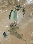 July 2002 – The sea's former bed is visible as lighter-colored areas, the lightest regions representing the most recent retreat.
 November 2003 – Much of the Eastern Sea's water has evaporated, the jade green swirls representing sediment in the shallow water.
 August 2009 – The Eastern Sea's mud flats have dried further, with only the faintest glimmer of water where it drains into the Western Sea. Barsakelmes Lake appears between the Northern and Western seas.
 July 2010 – A closeup of the channel leading from the re-flooded Eastern Sea to the Western Sea. The white areas are the exposed salt flats of the new Aralkum desert.
 August 2010 – Part of the Eastern Sea has been re-flooded by the Amu Darya from heavy snowmelt.
 September 2011 – The Northern Sea and Eastern Sea lost water, while the Western Sea gained more water.
 August 2014 – The Aral Sea completely loses its Eastern Lobe.


