South Attleboro station

Last updated

South Attleboro
Outbound train arriving at South Attleboro station, June 2013.JPG
An outbound train arrives at South Attleboro in June 2013
General information
Location1315 Newport Avenue
Attleboro, Massachusetts
Coordinates 41°53′51″N71°21′21″W / 41.8976°N 71.3558°W / 41.8976; -71.3558
Line(s) Attleboro Line (Northeast Corridor)
Platforms2 side platforms
Tracks2
ConnectionsAiga bus trans.svg GATRA: 11, 16
Aiga bus trans.svg RIPTA: 1, 35
Construction
Parking579 spaces ($6.00 fee) [1]
Bicycle facilities2 spaces
AccessibleYes
Other information
Fare zone7
History
OpenedJuly 30, 1990
ClosedFebruary 26, 2021–May 20, 2024
Passengers
20181,144 (weekday average boardings) [2]
Services
Preceding station MBTA.svg MBTA Following station
Pawtucket/​Central Falls Providence/​Stoughton Line Attleboro
Pawtucket/​Central Falls
toward Providence
Foxboro event service Attleboro
toward Foxboro
Location
South Attleboro station

South Attleboro station is an MBTA Commuter Rail Providence/Stoughton Line station in Attleboro, Massachusetts. It is located under Newport Avenue (Route 1A) in the South Attleboro neighborhood, just north of the Rhode Island border. The station has two side platforms serving the two tracks of the Northeast Corridor, formerly connected by a footbridge to a park-and-ride lot; only the north platform is in use.

Contents

Construction of the station was approved in 1987 and completed the next year. Opening was delayed by a dispute between the Massachusetts Bay Transportation Authority (MBTA) and the Massachusetts Architectural Access Board (MAAB) because the station was not accessible. After the MBTA and MAAB reached an agreement on the length of accessible platforms, the station opened in July 1990. The footbridge was in poor condition by the 2010s, with two sets of stairs closed off. The MBTA issued a contract for design of station improvements, including a new footbridge with elevators, in 2020. The station was temporarily closed on February 26, 2021, due to structural deterioration. Demolition of the footbridge took place in 2023. The MBTA resumed limited service at the station on May 20, 2024.

Station design

South Attleboro station is located under the Newport Avenue (Route 1A) overpass at the far southern edge of Attleboro, just 500 feet (150 m) from the Rhode Island line. [3] The station has two 780-foot (240 m)-long side platforms bracketing the two tracks of the Northeast Corridor; only the north platform is in use. [4] At the west end of the low platforms are 60-foot (18 m) high-level "mini-high" platforms that provide accessible boarding. [5] A footbridge with ramps and stairs formerly connected the south (northbound) platform to the southbound platform and the parking lot on the north side of the tracks. Pre-COVID, the 579-space parking lot filled before the end of the morning peak. [6] [1]

History

Former stations

The Boston and Providence Railroad (B&P) opened a new route from East Junction (near Hebronville in Attleboro) to Providence via Pawtucket in October 1847 to serve a new downtown Providence station. [7] :29 There was no station at the modern site, which was not in a populated area during the 19th century; the nearest stations were at Hebronville to the east and Pawtucket–​Central Falls to the west. [8] [9] The B&P was acquired in 1888 by the Old Colony Railroad, which was in turn acquired by the New York, New Haven and Hartford Railroad in 1893. [9] The Massachusetts Bay Transportation Authority (MBTA) was formed in 1964 to subsidize suburban commuter rail operations; the line became the Providence/Stoughton Line. Hebronville closed before the MBTA era, while Pawtucket–Central Falls closed on February 20, 1981 when Rhode Island stopped its subsidies and service was cut back to Attleboro. [10]

Planning and construction

Accessible mini-high platforms at the station Mini-high platforms at South Attleboro station, June 2013.JPG
Accessible mini-high platforms at the station

In August 1987, the MBTA approved plans to build a new station at South Attleboro to relieve crowding at Attleboro station. [11] Commuter service returned to Providence on February 1, 1988, but the Pawtucket/Central Falls station remained closed. [10] The $3 million station was completed in September 1988; however, the Massachusetts Architectural Access Board (MAAB) refused to let the station open. The station did not meet state requirements for accessibility: the footbridge had only stairs and no ramps, and no high-level platforms had been built. [12]

The MBTA built ramps and "mini-high" platforms (short sections of high-level platforms) at an additional cost of $1 million in mid-1989. [12] However, the station remained closed because the MAAB insisted on full-length high-level platforms, while the MBTA wished to only build the cheaper mini-high platforms. [12] [13] The MBTA's appeal of the MAAB ruling (which came two years before the Americans with Disabilities Act mandated accessibility nationwide) had system-wide implications, particularly for the then-inaccessible Green Line. [13]

After a judge ruled in favor of the MBTA, the two agencies reached an agreement in March 1990 under which existing mini-high platforms would be extended to 45 feet (14 m) long, and accessible platforms would be installed at all commuter rail stations by 1997 (which did not occur). [5] South Attleboro station ultimately opened on July 30, 1990. [10] [14]

The MBTA began operating Providence–Foxboro service for events at Gillette Stadium in 1997, with South Attleboro as one of the intermediate stops. [15] [16] South Attleboro station was the southern terminus of regular weekend service on the line until June 29, 2006, when Rhode Island began funding weekend service to Providence. [10]

Reconstruction

The footbridge in 2013, with two deteriorated staircases closed Footbridge at South Attleboro station, June 2013.JPG
The footbridge in 2013, with two deteriorated staircases closed

In the 2010 Northeast Corridor Master Plan, Amtrak indicated long-term plans to add two outer station sidings and high-level platforms to South Attleboro, allowing Amtrak trains to pass stopped MBTA trains. [4] More immediately, portions of the station were in poor condition, with a 2012 report indicating that two sets of stairs were closed due to rust damage. Although the station had mini-high platforms for level boarding, certain accessible-required elements such as tactile platform edges were missing. [6]

MBTA plans for a $4.9 million renovation, which would not have fixed the footbridge, were criticized by local officials in 2019. [17] That November, $4 million for design of a more extensive renovation was approved by the MBTA Fiscal Management Board. [18] The project will include full-length high-level platforms, a new footbridge with elevators, an improved bus stop, and changes to the parking lot. [19] Design work began in April 2020 and was expected to last 18 months. [20] Some repairs were considered to be made in the interim. [21]

On February 26, 2021, the station was closed due to deterioration of the overpass. [22] By March 2021, the reconstruction was expected to cost $48 million, of which only $7 million had been funded; the existing station was expected to reopen in April. [23] [24] However, in May 2021 the MBTA indicated that the station would remain closed until the reconstruction project was complete. [25] Design reached 75% completion in September 2021 and 100% in April 2022. [26] [27] [28] By January 2023, funding for the station had not yet been approved. [29]

In July 2022, the MBTA indicated that the old footbridge would be removed that fall. [19] Early construction was expected to last through February 2023. [30] However, demolition work did not actually begin until April 17, 2023. [31] Only a small portion was removed before work was paused "due to procedural issues". [32] Demolition work resumed in late September and was completed on October 14. [33] [34]

The MBTA reopened the station with "limited peak-hour service" – three daily round trips using only the north platform – on May 20, 2024. [35] [36]

Bus connections

South Attleboro station is served by three local bus routes, which stop at the Bristol Place shopping center just to the east: Greater Attleboro Taunton Regional Transit Authority (GATRA) routes 11 and 16, and Rhode Island Public Transit Authority (RIPTA) routes 1 and 35. [37] [38]

By federal law, bus systems like RIPTA that receive federal funds usually cannot cross state lines; thus, despite demand, RIPTA previously could not run directly to the station. In 2009, the agency considered building a $300,000 bus turnaround for the 77 (now 1) route just over the Rhode Island border. [3] In 2013, RIPTA began a two-year-long systemwide reorganization; one specific objective of the project was to secure federal permission to run directly to South Attleboro. [39] RIPTA extended routes 1 and 35 to Bristol Place in June 2014. [40] GATRA service to Bristol Place was discontinued prior to 2012 due to low ridership, but resumed in 2015. [6] [41]

Related Research Articles

<span class="mw-page-title-main">JFK/UMass station</span> Transit station in Boston, Massachusetts, US

JFK/UMass station is a Massachusetts Bay Transportation Authority (MBTA) intermodal transfer station, located adjacent to the Columbia Point area of Dorchester, Boston, Massachusetts. It is served by the rapid transit Red Line; the Greenbush Line, Kingston/Plymouth Line, and Middleborough/Lakeville Line of the MBTA Commuter Rail system, and three MBTA bus routes. The station is named for the John F. Kennedy Presidential Library and Museum and the University of Massachusetts Boston, both located nearby on Columbia Point.

<span class="mw-page-title-main">MBTA Commuter Rail</span> Greater Boston commuter rail system

The MBTA Commuter Rail system serves as the commuter rail arm of the Massachusetts Bay Transportation Authority's (MBTA's) transportation coverage of Greater Boston in the United States. Trains run over 394 mi (634 km) of track to 134 stations. It is operated under contract by Keolis, which took over operations on July 1, 2014, from the Massachusetts Bay Commuter Railroad Company (MBCR).

<span class="mw-page-title-main">Route 128 station</span> Rail station in Westwood, MA

Route 128 station is a passenger rail station located at the crossing of the Northeast Corridor and Interstate 95/US Route 1/Route 128 at the eastern tip of Dedham and Westwood, Massachusetts, United States. The station is shared by Amtrak and the Massachusetts Bay Transportation Authority (MBTA). It is served by most MBTA Commuter Rail Providence/Stoughton Line trains, as well as by all Amtrak Northeast Regional and Acela intercity trains. The station building, platforms, and parking garage are all fully accessible. It is the 23rd busiest Amtrak station in the country and the fifth busiest in New England.

<span class="mw-page-title-main">Ruggles station</span> Transit hub in Boston, Massachusetts, US

Ruggles station is an intermodal transfer station in Boston, Massachusetts. It serves Massachusetts Bay Transportation Authority (MBTA) rapid transit, bus, and commuter rail services and is located at the intersection of Ruggles and Tremont streets, where the Roxbury, Fenway–Kenmore, and Mission Hill neighborhoods meet. It is surrounded by the campus of Northeastern University. Ruggles is a station stop for the Orange Line subway, as well as the Providence/Stoughton Line, Franklin/Foxboro Line, and Needham Line of the MBTA Commuter Rail system. Thirteen MBTA bus routes stop at Ruggles.

<span class="mw-page-title-main">Malden Center station</span> Transit station in Malden, Massachusetts, US

Malden Center station is a Massachusetts Bay Transportation Authority (MBTA) intermodal transit station in Malden, Massachusetts. Located on an elevated grade above Pleasant Street in downtown Malden, it serves the rapid transit Orange Line and the MBTA Commuter Rail Haverhill Line. The station has one island platform for the two Orange Line tracks and a single side platform for the single commuter rail track. Two busways are used by 12 MBTA bus routes.

<span class="mw-page-title-main">Fairmount Line</span> MBTA Commuter Rail line

The Fairmount Line or Dorchester Branch is a line of the MBTA Commuter Rail system in Boston, Massachusetts, USA. Except for a short portion in Milton, it lies entirely within Boston, running southwest from South Station through the neighborhoods of Dorchester, Mattapan and Hyde Park. Weekend service began on November 29, 2014. Most trains reverse direction at the south end at Readville, but some Franklin/Foxboro Line trains use the Fairmount Line rather than the Northeast Corridor.

<span class="mw-page-title-main">Providence station</span> Railway station in Providence, Rhode Island, US

Providence station is a railroad station in Providence, Rhode Island, served by Amtrak and MBTA Commuter Rail. The station has four tracks and two island platforms for passenger service, with a fifth track passing through for Providence and Worcester Railroad freight trains. It is now the 11th busiest Amtrak station in the country, and the second-busiest on the MBTA Commuter Rail system outside of Boston.

<span class="mw-page-title-main">Foxboro station</span> Train station in Foxborough, Massachusetts, US

Foxboro station is an MBTA Commuter Rail station in Foxborough, Massachusetts, located adjacent to Gillette Stadium and the Patriot Place shopping center. The station has a single side platform serving the main track of the Framingham Secondary. It is the terminus of a branch of the Franklin/Foxboro Line service, and is served by trains from Boston via the Franklin/Foxboro Line and from Providence via the Providence/Stoughton Line during events at Gillette Stadium.

<span class="mw-page-title-main">Braintree station (MBTA)</span> Transit station in Braintree, Massachusetts, US

Braintree station is an intermodal transit station in Braintree, Massachusetts. It serves the MBTA's Red Line and the MBTA Commuter Rail Old Colony Lines as well as MBTA buses.

<span class="mw-page-title-main">Quincy Center station</span> Transit station in Quincy, Massachusetts, US

Quincy Center station is an intermodal transit station in Quincy, Massachusetts. It is a transfer station between the MBTA Red Line subway, MBTA Commuter Rail's Old Colony Lines and Greenbush Line, and a number of MBTA bus routes. It is located between Hancock Street and Burgin Parkway in the Quincy Center district. Opened in 1971, the station was covered by a large parking garage which was closed in 2012 due to structural problems and removed several years later. The station is accessible on all modes.

<span class="mw-page-title-main">Providence/Stoughton Line</span> Line of the Boston MBTA Commuter Rail system

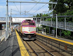
The Providence/Stoughton Line is an MBTA Commuter Rail service in Massachusetts and Rhode Island, primarily serving the southwestern suburbs of Boston. Most service runs entirely on the Northeast Corridor between South Station in Boston and Providence station or Wickford Junction station in Rhode Island, while the Stoughton Branch splits at Canton Junction and terminates at Stoughton. It is the longest MBTA Commuter Rail line, and the only one that operates outside Massachusetts. The line is the busiest on the MBTA Commuter Rail system, with 17,648 daily boardings in an October 2022 count.

<span class="mw-page-title-main">Providence metropolitan area</span> Metropolitan Statistical Area in the United States

The Providence metropolitan area is a region extending into eight counties in two states. Its core is in the states of Rhode Island and Massachusetts, and it is the 38th largest metropolitan area in the United States. The largest city in the Providence MSA is Providence, Rhode Island, with an estimated population of 1,622,520, exceeding that of Rhode Island by slightly over 60%. The MSA covers all of Rhode Island and Bristol County, Massachusetts, with an average population density of 2300 per mi2.

<span class="mw-page-title-main">Readville station</span> Railway station in Boston, Massachusetts, US

Readville station is a Massachusetts Bay Transportation Authority (MBTA) commuter rail station located in the Readville section of the Hyde Park neighborhood of Boston, Massachusetts. It is served by the MBTA Commuter Rail Fairmount, Franklin/Foxboro, and Providence/Stoughton Lines. Readville is the outer terminus for most Fairmount service, though some trips continue as Franklin/Foxboro Line trains. The station is located at a multi-level junction, with the Attleboro Line tracks at ground level and the Dorchester Branch above. Franklin/Foxboro Line trains that run on the Northeast Corridor use a connecting track with a separate platform. An MBTA maintenance and storage yard and a CSX Transportation freight yard are located near the station.

<span class="mw-page-title-main">Attleboro station (Massachusetts)</span> Railway station in Attleboro, Massachusetts, US

Attleboro station is a commuter rail station on the MBTA's Providence/Stoughton Line located in Attleboro, Massachusetts. By a 2018 count, Attleboro had 1,547 daily riders, making it the fourth busiest station on the system outside Boston.

<span class="mw-page-title-main">Mansfield station (MBTA)</span> Rail station in Mansfield, Massachusetts, US

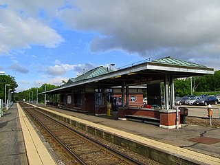
Mansfield station is an MBTA Commuter Rail station in Mansfield, Massachusetts. Located in downtown Mansfield, it serves the Providence/Stoughton Line. With 1,966 weekday boardings in a 2018 count, Mansfield is the third-busiest station on the system outside Boston.

<span class="mw-page-title-main">Forge Park/495 station</span> Rail station in Franklin, Massachusetts, US

Forge Park/495 station is a Massachusetts Bay Transportation Authority (MBTA) commuter rail station served by the Franklin/Foxboro Line. It is located off Route 140 near Interstate 495 in Franklin, Massachusetts, United States. A park and ride station serving southwestern Boston suburbs and northeastern Rhode Island, it is the outer terminus of the Franklin/Foxboro Line. The station has two side platforms serving a single track, with an accessible mini-high platform and a station building on the south platform.

<span class="mw-page-title-main">Lansdowne station (MBTA)</span> Railway station in Boston, Massachusetts, US

Lansdowne station is an MBTA Commuter Rail station in Boston, Massachusetts. It serves the Framingham/Worcester Line. Lansdowne is located next to the Massachusetts Turnpike in the Fenway–Kenmore neighborhood near Kenmore Square, below grade between Beacon Street and Brookline Avenue.

<span class="mw-page-title-main">Winchester Center station</span> Train station in Winchester, Massachusetts, US

Winchester Center station is a temporarily closed MBTA Commuter Rail station in Winchester, Massachusetts, normally served by the Lowell Line. The station, located on a viaduct in downtown Winchester, was closed effective January 8, 2021 due to structural deterioration. Winchester Center station was not accessible prior to the closure, but accessible high-level platforms are being added during renovations taking place from December 2021 to October 2024.

<span class="mw-page-title-main">Pawtucket/Central Falls station</span> Railway station in Rhode Island, US

Pawtucket/Central Falls station is a commuter rail station in Pawtucket, Rhode Island. It opened for MBTA Commuter Rail Providence/Stoughton Line service on January 23, 2023. The station has two side platforms serving the two tracks of the Northeast Corridor. It is also a hub for RIPTA local bus service.

References

  1. 1 2 "South Attleboro". Massachusetts Bay Transportation Authority. Retrieved October 12, 2020.
  2. Central Transportation Planning Staff (2019). "2018 Commuter Rail Counts". Massachusetts Bay Transportation Authority.
  3. 1 2 Barrett, Chris (December 24, 2009). "RIPTA buses may stop near Mass. trains". Providence Business Journal. Archived from the original on July 3, 2014. Retrieved 3 July 2014.
  4. 1 2 The NEC Master Plan Working Group (May 2010). "The Northeast Corridor Infrastructure Master Plan" (PDF). Part II: page 7. Amtrak.
  5. 1 2 Rosenberg, Ronald (March 31, 1990). "Accord should improve commuter rail access for the accessible by '97". Boston Globe. p. 40 via Newspapers.com. Open Access logo PLoS transparent.svg
  6. 1 2 3 Southeastern Massachusetts Metropolitan Planning Organization and Southeastern Regional Planning and Economic Development District (2012). "Commuter Rail" (PDF). 2012 Regional Transportation Plan. Archived from the original (PDF) on October 16, 2013.
  7. Humphrey, Thomas J.; Clark, Norton D. (1985). Boston's Commuter Rail: The First 150 Years. Boston Street Railway Association. ISBN   9780685412947.
  8. "Town of Attleboro". New topographical atlas of surveys: Bristol County, Massachusetts. Everts and Richards. 1895. pp. 92–93. hdl:2452/206017 via Massachusetts State Archives.
  9. 1 2 Karr, Ronald Dale (2017). The Rail Lines of Southern New England (2 ed.). Branch Line Press. p. 176. ISBN   9780942147124.
  10. 1 2 3 4 Belcher, Jonathan. "Changes to Transit Service in the MBTA district" (PDF). Boston Street Railway Association.
  11. Howe, Peter J. (August 23, 1987). "MBTA to build police facility, South Attleboro rail station". Boston Globe. p. 34 via Newspapers.com. Open Access logo PLoS transparent.svg
  12. 1 2 3 Ackerman, Jerry (March 8, 1989). "T pressured to open all routes to accessible". Boston Globe. pp. 1, 16 via Newspapers.com. (second page, third page) Open Access logo PLoS transparent.svg
  13. 1 2 Ackerman, Jerry (May 29, 1989). "Forest Hills streetcar service on hold". Boston Globe. p. 18 via Newspapers.com. Open Access logo PLoS transparent.svg
  14. Rosenberg, Ronald (July 30, 1990). "Starts and Stops: Old Colony line inspires a petition duel". Boston Globe. p. 18 via Newspapers.com. Open Access logo PLoS transparent.svg
  15. "[Advertisement]". Boston Globe. October 11, 1996. p. 90 via Newspapers.com.
  16. "If you're going to the game..." Boston Globe. September 14, 1997. p. 64 via Newspapers.com.
  17. Hand, Jim (July 31, 2019). "Lawmakers want more repairs to South Attleboro train station". The Sun Chronicle.
  18. Mia Ping-Chieh Chen (November 7, 2019). "MBTA board OK's Attleboro commuter line electrification, South Attleboro Station upgrades". The Sun Chronicle.
  19. 1 2 Naidoo, Nayan (July 2022). "South Attleboro Station Accessibility Improvements: Prerecorded Overview– 100% Design Update" (PDF). Massachusetts Bay Transportation Authority.
  20. Brelsford, Laura (May 26, 2020). "SWA Initiatives—May 2020" (PDF). p. 8.
  21. Hand, Jim (January 9, 2020). "South Attleboro rail overpass is safe, transportation chief says". The Sun Chronicle.
  22. "Alerts: Commuter Rail". Massachusetts Bay Transportation Authority. February 26, 2021. Archived from the original on January 8, 2021.
  23. "Accessibility Improvements at South Attleboro Station: 30% Design – Virtual Public Meeting" (PDF). Massachusetts Bay Transportation Authority. March 4, 2021.
  24. "Report from the General Manager" (PDF). Massachusetts Bay Transportation Authority. March 29, 2021. p. 19.
  25. Brelsford, Laura (May 24, 2021). "System-Wide Accessibility Initiatives—May 2021" (PDF). Massachusetts Bay Transportation Authority Department of System-Wide Accessibility. p. 7.
  26. Lorence, Stella (September 30, 2021). "Design plans nearing completion for overhaul of South Attleboro train station, official says". The Sun Chronicle. Retrieved September 30, 2021.
  27. "System-Wide Accessibility Initiatives—December 2021" (PDF). Massachusetts Bay Transportation Authority Department of System-Wide Accessibility. December 2021. p. 7.
  28. "System-Wide Accessibility Initiatives—May 2022" (PDF). Massachusetts Bay Transportation Authority Department of System-Wide Accessibility. May 2022. p. 7.
  29. Rhodes, George W. (January 18, 2023). "South Attleboro commuter rail station project still awaiting funding". Sun Chronicle. Retrieved January 23, 2023.
  30. "South Attleboro Station Accessibility Improvements Project Construction Work to Take Place beginning This Fall 2022" (Press release). Massachusetts Bay Transportation Authority. August 4, 2022.
  31. Rhodes, George W. (April 16, 2023). "Demo work to start on dilapidated South Attleboro commuter rail station". The Sun Chronicle. Retrieved April 17, 2023.
  32. Rhodes, George W. (June 29, 2023). "Work stalls at closed MBTA station in South Attleboro". The Sun Chronicle. Retrieved June 30, 2023.
  33. Rhodes, George W. (September 18, 2023). "Demolition at South Attleboro MBTA commuter rail station now expected to be done by end of October". The Sun Chronicle. Retrieved September 21, 2023.
  34. Rhodes, George W. (November 1, 2023). "South Attleboro train station demo done; MBTA looking for funding to rebuild". The Sun Chronicle. Retrieved November 25, 2023.
  35. Coholan, Ryan (April 25, 2024). "Spring 2024 Transportation Schedule Changes" (PDF). Massachusetts Bay Transportation Authority. p. 7.
  36. Messier, Paige (April 25, 2024). "MBTA reopening South Attleboro train station". Archived from the original on April 26, 2024.
  37. "Statewide System Map". Rhode Island Public Transit Authority. 22 April 2020. Retrieved October 8, 2020.
  38. "Routes". Greater Attleboro Taunton Regional Transit Authority. Retrieved September 26, 2023.
  39. Landis, Bruce (May 21, 2013). "RIPTA prepares to reorganize routes to improve service". Providence Journal. Archived from the original on 4 May 2019. Retrieved July 8, 2014.
  40. Public Hearing & Comment Period Report: Rhode Island State Rail Plan (PDF). State Planning Council Transportation Advisory Committee. March 13, 2014. p. 3. Archived from the original (PDF) on October 16, 2020. Retrieved October 8, 2020.
  41. "GATRA shifts to meet needs of customers". The Sun Chronicle. March 9, 2016. Retrieved October 7, 2020.