History
South and North Charford are usually identified with the "Cerdic's ford" which appears twice in the Anglo-Saxon Chronicle . It first is mentioned under the entry for the year 508 when we are told that following a battle to the east "the land as far as Cerdic's ford was named Natanleaga [1] " For the year 519 we are told that "Cerdic and Cynric succeeded to the kingdom [of the West Saxons]; and in the same year they fought against the Britons at a place called Cerdic's ford". If a battle really did take place here then it is possible that the boundary of Hampshire was first established here. [2]
In the time of the Domesday Book of 1086, South Charford (Cerdeford) was a fairly large settlement of around 24 households. [3] The manor was held of Hugh de Port by William de Chernet, and it remained in the Chernet family for over 200 years. [4] In 1293 Iseult de Chernet was dealing with the manor, which passed by inheritance or purchase to Oliver de la Zouche. [4] Sometime before 1428 it was evidently sold it to Sir John Popham, who served in France under Henry V and the Duke of Bedford. [4] It then came into the possession of the Bulkeley family and followed the descent of Burgate in Fordingbridge until 1600, when John Bulkeley conveyed it to Hugh Grove. [4] Sir William Dodington was holding it in 1624. His son Herbert died childless in 1633, and his father, who survived, held the manor until his death in 1638, when it passed to his younger son John. [4] South Charford passed by sale or settlement to Fulke Greville, 5th Baron Brooke, and remained in his family until 1747–8, when Francis Greville, 8th Baron Brooke sold his Hampshire estates. [4] South Charford passed to Henry Archer and then followed the descent of North Charford. [4]
A chapel is said to have been built by Sir John Popham with the consent of the Prior of Breamore, and was dedicated in 1404. [4] The chapel was in ruins by the mid 18th-century when Thomas Archer made use of the material for enlarging and rebuilding of the church of Hale. [4] The site is in a field near South Charford Farm, [4] and is now occupied by a large yew tree. [5]
South Charford was long a separate parish, although for a period in the early 19th-century it was reckoned as a tithing of the parish of North Charford. [4] The population of South Charford in 1870 was 70 people living in 13 houses. [6] In 1931 the parish had a population of 89. [7] On 1 April 1932 the parish was abolished and merged with Breamore and Hale. [8] There is no village today — just a few farm buildings.

Cerdic is described in the Anglo-Saxon Chronicle as a leader of the Anglo-Saxon settlement of Britain, being the founder and first king of Wessex, reigning from around 519 to 534 AD. Subsequent kings of Wessex were each claimed by the Chronicle to descend in some manner from Cerdic. His origin, ethnicity, and even his very existence have been extensively disputed. However, though claimed as the founder of Wessex by later West Saxon kings, he would have been known to contemporaries as king of the Gewissae, a folk or tribal group. The first king of the Gewissae to call himself 'King of the West Saxons', was Cædwalla, in a charter of 686.

Fordingbridge is a town and broader civil parish with a population of 6,000 on the River Avon in the New Forest District of Hampshire, England, near the Dorset and Wiltshire borders and on the edge of the New Forest, famed for its late medieval seven-arch bridge.

Hordle is a village and civil parish in the county of Hampshire, England. It is situated between the Solent coast and the New Forest, and is bordered by the towns of Lymington and New Milton. Like many New Forest parishes Hordle has no village centre. The civil parish includes the hamlets of Tiptoe and Everton as well as part of Downton. The parish was originally much larger; stretching from the New Forest boundary to Hurst Castle.

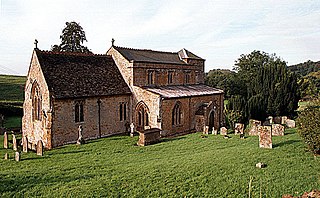
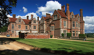
Breamore is a village and civil parish near Fordingbridge in Hampshire, England. The parish includes a notable Elizabethan country house, Breamore House, built with an E-shaped ground plan. The Church of England parish church of Saint Mary has an Anglo-Saxon rood.

Godshill is a village and civil parish and in New Forest National Park in Hampshire, England. It is about 1+1⁄2 miles (2.4 km) east of the town of Fordingbridge and 10 miles (16 km) south of the city of Salisbury.

Hale is a small village and civil parish in Hampshire, England. It lies on the border of the New Forest, overlooking the valley of the River Avon. The village is about 3.5 miles (5.6 km) north-east of the town of Fordingbridge, and about 8 miles (13 km) south of the city of Salisbury. Within the parish stands Hale House, a large 18th-century mansion which was the country house of architect Thomas Archer, who also rebuilt Hale church in 1717.

North Charford is a hamlet in the civil parish of Breamore, in the New Forest district, in Hampshire, England, near the Wiltshire border. Historically the name refers to a manor which is on the west bank of the River Avon.

Wolverton is a village in the civil parish of Baughurst, in the Basingstoke and Deane district in north Hampshire, England. It is approximately 7 miles (11 km) from both Newbury and Basingstoke.

Harbridge is a small village and former civil parish, now in the parish of Ellingham, Harbridge and Ibsley, in the New Forest district, in the county of Hampshire, England. It is located some four kilometres north of Ringwood and a similar distance south of Fordingbridge, in southwest Hampshire. In 1931 the parish had a population of 276.
Drayton is a village and civil parish in the valley of the Sor Brook in Oxfordshire, about 2 miles (3 km) northwest of Banbury. The 2011 Census recorded the parish's population as 242.
Anne Hoby was an English heiress.

Netley Marsh is a village and civil parish in Hampshire, close to the town of Totton. It lies within the New Forest District, and the New Forest National Park. It is the supposed site of the battle between an invading Anglo Saxon army, under Cerdic and a British army under the probably fictitious king Natanleod in the year 508.
Stoke Charity is a small village and former civil parish, now in the parish of Wonston, in the City of Winchester district of Hampshire, England. It is on the River Dever, its nearest town is Winchester, which lies approximately 6.1 miles (9.9 km) south-west from the village. In 1931 the parish had a population of 111.
John Doddington was an English landowner and politician who sat in the House of Commons in 1640.

Culverthorpe is a hamlet in the civil parish of Culverthorpe and Kelby, in the North Kesteven district of Lincolnshire, England. It lies 5 miles (8 km) south-west from Sleaford, 9 miles (14 km) north-east from Grantham and 3 miles (5 km) south-east from Ancaster.

Popham is a hamlet and civil parish south of Basingstoke, Hampshire, England. According to the Post Office the population of the 2011 Census was included in the civil parish of Dummer. The area was occupied from pre-historic times and was established as a permanent habitation during the Roman occupation of Britain. The manor of Popham was established by the monastery of Winchester as an outlying agricultural grain station. A small church and school were later established, but have long since disappeared. The parish and hamlet were later dissected by the M3 Motorway and A303 trunk road. Although named for Popham, Popham Airfield and the Popham Little Chef restaurant are situated in the neighbouring parish of Steventon.
Sir William Doddington (1572–1638) was an English landowner and politician who sat in the House of Commons from 1621 to 1622.
Thomas Hoby JP DL of Bisham Abbey, Berkshire and Breamore, Hampshire, was an English politician.

Calthorpe is a small village and former civil parish, now in the parish of Erpingham, in the North Norfolk district, in the county of Norfolk, England. The village is located 0.5 miles (0.80 km) west of the village of Erpingham, 3.4 miles (5.5 km) north of the nearest town of Aylsham and is 15.8 miles (25.4 km) north of the nearest city of Norwich. The nearest railway station is at Gunton for the Bittern Line which runs between Sheringham, Cromer and Norwich and is 7.8 miles (12.6 km) from the village. The nearest airport is Norwich International 14.2 miles (22.9 km) south of the village. In 1931 the parish had a population of 143.
Preston is a village, former manor, civil and ecclesiastical parish in the Forest of Dean in Gloucestershire, England. It is situated 22 km north-west of the city of Gloucester and 4 km south-west of the Herefordshire town of Ledbury. In 1931 the parish had a population of 77. On 1 April 1935 the parish of Preston, comprising 897 acres, was added to the parish of Dymock, adjacent at the south-east, the parish church of which, St Mary the Virgin, is situated 4 miles to the south-east.


