South Cle Elum, Washington

Last updated

South Cle Elum, Washington
Kittitas County Washington Incorporated and Unincorporated areas South Cle Elum Highlighted.svg
Location of South Cle Elum, Washington
Coordinates: 47°11′8″N120°57′11″W / 47.18556°N 120.95306°W / 47.18556; -120.95306
Country United States
State Washington
County Kittitas
Area
[1]
  Total0.40 sq mi (1.04 km2)
  Land0.40 sq mi (1.04 km2)
  Water0.00 sq mi (0.00 km2)
Elevation
1,923 ft (586 m)
Population
 (2020)
  Total559
  Density1,400/sq mi (540/km2)
Time zone UTC-8 (Pacific (PST))
  Summer (DST) UTC-7 (PDT)
ZIP code
98943
Area code 509
FIPS code 53-65765
GNIS feature ID1526142 [2]

South Cle Elum is a town in Kittitas County, Washington, United States. The population was 559 at the 2020 census. [3]

Contents

History

In 1909, the Chicago, Milwaukee & Puget Sound Railway chose Cle Elum as a division point between the Coast and Columbia divisions on its future transcontinental line. [4] When it was determined that Milwaukee's mainline would end up running one mile south of the city, South Cle Elum was platted. Maintenance shops and workers' bunkers were built as well as a train station. South Cle Elum was officially incorporated on August 28, 1911.

Geography

South Cle Elum is located at 47°11′8″N120°57′11″W / 47.18556°N 120.95306°W / 47.18556; -120.95306 (47.185633, −120.953019). [5]

According to the United States Census Bureau, the town has a total area of 0.39 square miles (1.01 km2), all land. [6]

Climate

Climate data for South Cle Elum, Washington
MonthJanFebMarAprMayJunJulAugSepOctNovDecYear
Record high °F (°C)65
(18)
69
(21)
95
(35)
96
(36)
99
(37)
100
(38)
105
(41)
105
(41)
98
(37)
96
(36)
68
(20)
66
(19)
105
(41)
Mean daily maximum °F (°C)36
(2)
41
(5)
50
(10)
57
(14)
65
(18)
71
(22)
80
(27)
80
(27)
73
(23)
58
(14)
43
(6)
33
(1)
57
(14)
Mean daily minimum °F (°C)24
(−4)
24
(−4)
30
(−1)
34
(1)
41
(5)
47
(8)
53
(12)
52
(11)
43
(6)
34
(1)
29
(−2)
22
(−6)
36
(2)
Record low °F (°C)−33
(−36)
−30
(−34)
0
(−18)
12
(−11)
19
(−7)
26
(−3)
30
(−1)
30
(−1)
21
(−6)
10
(−12)
−14
(−26)
−31
(−35)
−33
(−36)
Average precipitation inches (mm)2.98
(76)
2.66
(68)
1.98
(50)
1.07
(27)
1.15
(29)
0.89
(23)
0.59
(15)
0.50
(13)
0.81
(21)
1.91
(49)
4.31
(109)
3.50
(89)
22.35
(569)
Source: [7]

Demographics

Historical population
CensusPop.Note
1920 587
1930 338−42.4%
1940 3400.6%
1950 44230.0%
1960 383−13.3%
1970 374−2.3%
1980 44920.1%
1990 4571.8%
2000 4570.0%
2010 53216.4%
2020 5595.1%
U.S. Decennial Census [8]

2010 census

As of the 2010 census, [9] there were 532 people, 235 households, and 145 families residing in the town. The population density was 1,364.1 inhabitants per square mile (526.7/km2). There were 271 housing units at an average density of 694.9 per square mile (268.3/km2). The racial makeup of the town was 93.2% White, 0.4% African American, 1.5% Native American, 0.8% Asian, 1.5% from other races, and 2.6% from two or more races. Hispanic or Latino of any race were 5.1% of the population.

There were 235 households, of which 28.5% had children under the age of 18 living with them, 49.8% were married couples living together, 8.9% had a female householder with no husband present, 3.0% had a male householder with no wife present, and 38.3% were non-families. 30.2% of all households were made up of individuals, and 11.5% had someone living alone who was 65 years of age or older. The average household size was 2.26 and the average family size was 2.80.

The median age in the town was 42.8 years. 21.2% of residents were under the age of 18; 8% were between the ages of 18 and 24; 24% were from 25 to 44; 28.3% were from 45 to 64; and 18.6% were 65 years of age or older. The gender makeup of the town was 49.6% male and 50.4% female.

2000 census

At the 2000 census, there were 457 people, 185 households and 123 families residing in the town. The population density was 1,089.5 per square mile (420.1/km2). There were 210 housing units at an average density of 500.6 per square mile (193.1/km2). The racial makeup of the town was 94.09% White, 1.31% Native American, 0.22% Asian, 2.41% from other races, and 1.97% from two or more races. Hispanic or Latino of any race were 4.38% of the population.

There were 185 households, of which 35.1% had children under the age of 18 living with them, 54.6% were married couples living together, 7.6% had a female householder with no husband present, and 33.5% were non-families. 29.7% of all households were made up of individuals, and 15.1% had someone living alone who was 65 years of age or older. The average household size was 2.47 and the average family size was 3.03.

Age distribution was 29.5% under the age of 18, 3.3% from 18 to 24, 30.0% from 25 to 44, 22.5% from 45 to 64, and 14.7% who were 65 years of age or older. The median age was 38 years. For every 100 females, there were 103.1 males. For every 100 females age 18 and over, there were 96.3 males.

The median household income was $45,833, and the median family income was $53,750. Males had a median income of $35,625; females, $21,625. The per capita income for the town was $22,375. About 8.1% of families and 6.6% of the population were below the poverty line, including 3.9% of those under age 18 and 7.6% of those age 65 or over.

Points of Interest in South Cle Elum

Notable people

Related Research Articles

<span class="mw-page-title-main">Kittitas County, Washington</span> County in Washington, United States

Kittitas County is a county located in the U.S. state of Washington. At the 2020 census, its population was 44,337. Its county seat and largest city is Ellensburg. The county was created in November 1883 when it was carved out of Yakima County. Kittitas County comprises the Ellensburg, Washington, Micropolitan Statistical Area.

<span class="mw-page-title-main">Martin, Georgia</span> Town in Georgia, United States

Martin is a town in Stephens and Franklin counties in the U.S. state of Georgia. The population was 381 at the 2010 census, up from 311 in 2000.

<span class="mw-page-title-main">Oldtown, Idaho</span> City in Idaho, United States

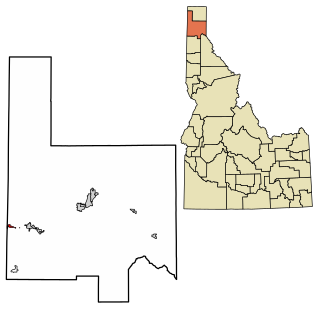
Oldtown is a city in Bonner County, Idaho and suburb of Newport, Washington, with a population of 184 at the 2010 census. It is located on the Pend Oreille River, just east of Newport. There are no natural or physical barriers, and it is strictly a political division, separated by the straight-line state boundary. Oldtown is squeezed between this boundary to the west and the river to the east, leaving the main business district on U.S. Route 2 with only 700 feet of space in which to operate on the Idaho side. Many homes are located in the south end on the other side of the railroad, as the Pend Oreille is somewhat further away here.

<span class="mw-page-title-main">Hillcrest, Illinois</span> Village in Illinois, United States

Hillcrest is a village located in Ogle County, Illinois, United States. The 2010 census lists its population at 1,326, up from 1,158 in 2000.

<span class="mw-page-title-main">Macksburg, Iowa</span> City in Iowa, United States

Macksburg is a city in Madison County, Iowa, United States. The population was 97 at the time of the 2020 census. It is part of the Des Moines–West Des Moines Metropolitan Statistical Area.

<span class="mw-page-title-main">Winifred, Montana</span> Town in Montana, United States

Winifred is a small town in rural north-central Fergus County, Montana, United States. It was founded in 1913 and provides services for its region's populace. The town population was 172 at the 2020 census. The current mayor is Travis Willson.

<span class="mw-page-title-main">New Eagle, Pennsylvania</span> Borough in Pennsylvania, United States

New Eagle is a borough in Washington County, Pennsylvania, United States and is part of the Pittsburgh Metro Area. The population was 2,047 at the 2020 census.

<span class="mw-page-title-main">Orient, South Dakota</span> Town in South Dakota, United States

Orient is a town in Faulk County, South Dakota, United States. The population was 51 at the 2020 census.

<span class="mw-page-title-main">Interior, South Dakota</span> Town in South Dakota, United States

Interior is a town in Jackson County, South Dakota, United States. The population was 65 at the 2020 census.

<span class="mw-page-title-main">Lennox, South Dakota</span> City in South Dakota, United States

Lennox is a city in Lincoln County, South Dakota, United States, located 20 miles (32 km) southwest of Sioux Falls. The population was 2,423 at the 2020 census.

<span class="mw-page-title-main">Gretna, Virginia</span> Town in Virginia, United States

Gretna is a town in Pittsylvania County, Virginia, United States. The population was 1,267 at the 2010 census. It is part of the Danville Micropolitan Statistical Area.

<span class="mw-page-title-main">Cle Elum, Washington</span> City in Washington, United States

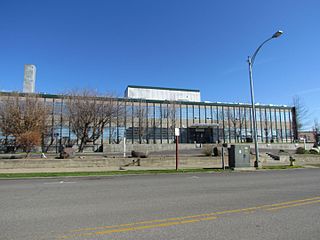
Cle Elum is a city in Kittitas County, Washington, United States. The population was 2,157 at the 2020 census. About 84 miles (135 km) by car from Seattle, Cle Elum is a popular area for camping and outdoor activities. It is also unofficially considered the starting point of Eastern Washington when driving east on I-90 from Seattle, although this is somewhat arbitrary since many consider either the town of Easton, anywhere east of Keechelus Lake, or the wildlife crossing bridge over I-90 to be the starting point.

<span class="mw-page-title-main">Ronald, Washington</span> Census-designated place in Washington, United States

Ronald is an unincorporated community and census-designated place (CDP) in Kittitas County, Washington, United States. The population was 308 at the 2010 census.

<span class="mw-page-title-main">Ravenswood, West Virginia</span> City in West Virginia, United States

Ravenswood is a city in Jackson County, West Virginia, United States, along the Ohio River. The population was 3,865 at the 2020 census.

<span class="mw-page-title-main">Jacksonport, Wisconsin</span> Town in Wisconsin, United States

Jacksonport is a town in Door County, Wisconsin, United States. The population was 738 at the 2000 census. The unincorporated communities of Jacksonport and West Jacksonport are located in the town. Part of Clark Lake is in the Town of Jacksonport.

<span class="mw-page-title-main">Greenfield, Wisconsin</span> City in Wisconsin, United States

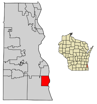
Greenfield is a city in Milwaukee County, Wisconsin, United States. The population was 37,803 as of the 2020 census. Greenfield is one of many bedroom communities in the Milwaukee metropolitan area.

<span class="mw-page-title-main">South Milwaukee, Wisconsin</span> City in Wisconsin, United States

South Milwaukee is a city in Milwaukee County, Wisconsin, United States. The population was 20,795 at the 2020 census.

<span class="mw-page-title-main">St. Francis, Wisconsin</span> City in Wisconsin, United States

St. Francis is a city in Milwaukee County, Wisconsin, United States. The population was 9,161 at the 2020 census.

<span class="mw-page-title-main">Bondurant, Wyoming</span> CDP in Wyoming, United States

Bondurant is a census-designated place (CDP) in Sublette County, Wyoming, United States. The population was 93 at the 2010 census. The town was named after B. F. Bondurant.

Hollins is a census-designated place (CDP) in Botetourt and Roanoke County, Virginia, United States. Hollins covers much of the area known locally as "North County". The population was 15,574 at the 2020 census. It is part of the Roanoke Metropolitan Statistical Area. The area is also the home of Hollins University in addition to four properties listed on the National Register of Historic Places: the Black Horse Tavern-Bellvue Hotel and Office, Harshbarger House, the Hollins College Quadrangle, and Old Tombstone.

References

  1. "2019 U.S. Gazetteer Files". United States Census Bureau. Retrieved August 7, 2020.
  2. "South Cle Elum". Geographic Names Information System . United States Geological Survey, United States Department of the Interior.
  3. "Census Bureau profile: South Cle Elum, Washington". United States Census Bureau. May 2023. Retrieved May 11, 2024.
  4. "Milwaukee Divisions Set" The Oregonian July 1, 1909.
  5. "US Gazetteer files: 2010, 2000, and 1990". United States Census Bureau. February 12, 2011. Retrieved April 23, 2011.
  6. "US Gazetteer files 2010". United States Census Bureau. Archived from the original on July 2, 2012. Retrieved December 19, 2012.
  7. "weather.com" . Retrieved November 15, 2011.
  8. United States Census Bureau. "Census of Population and Housing" . Retrieved July 21, 2014.
  9. "U.S. Census website". United States Census Bureau . Retrieved December 19, 2012.