South Island nationalism

Last updated

The South Island. South Island 2007-12-07.jpg
The South Island.

South Island nationalism refers to a nationalist movement in the South Island of New Zealand.

Contents

Julius Vogel, the 8th Premier of New Zealand, was a continual advocate of separation of the North and South Islands, which led to his dismissal from the Otago Daily Times in 1868. [1] The idea of independence was voted on by the New Zealand Parliament in 1865, and the concern the South Island could form a separate colony was one of the main factors in moving the capital of New Zealand from Auckland to the more centrally located Wellington in the same year.

History

Māori period

The successive waves of Māori iwi (tribes) to settle the South Island – namely the Waitaha, the Ngāti Mamoe, and Ngāi Tahu – had been politically independent from their northern counterparts. [2] Several attempts by the Ngāti Toa (from the Kāpiti Coast) to annex the island during the 1830s, under the leadership of Te Rauparaha, were eventually repelled by an alliance of the Southern chiefs of Otautahi and Murihiku. [3] By the time the first European settlers arrived in the South Island (then known natively as Te Waipounamu) in the early 1840s, the Ngāti Toa only held control of the Wairau plains.

This independence from North Island iwi and their political beliefs is still reflected in modern South Island Māori culture. During Waitangi Day celebrations in 2010, Ngai Tahu refused to fly the controversial Tino Rangatiratanga flag, with one tribe member saying the "flag has been nothing but trouble". [4]

There is also greater concern from South Island Maori in that the cultural renaming of Aotearoa does not reflect their ancestry link to their homeland of Aoraki/South Island.[ citation needed ] As Aotearoa referred solely to the north island but has been rolled out across the whole country with no consultation.

European discovery

The first Europeans known to reach the South Island were the crew of Dutch explorer Abel Tasman who arrived in his ships Heemskerck and Zeehaen. Tasman anchored in Golden Bay, at the northern end of the island, (he named it Murderers Bay) in December 1642 and sailed northward to Tonga following a clash with local Māori. Tasman sketched sections of the two main islands' west coasts. Tasman called them Staten Landt, after the States-General of the Netherlands , and that name appeared on his first maps of the country. Dutch cartographers changed the name to Nova Zeelandia in Latin, from Nieuw Zeeland, after the Dutch province of Zeeland . It was subsequently Anglicised as New Zealand by British naval captain James Cook of HM Bark Endeavour who visited the islands more than 100 years after Tasman during (1769–1770).

When Britain annexed New Zealand in 1840, New Zealand briefly became a part of New South Wales. [5] This annexation was in response to New Zealand Company attempts to establish a separate colony in Wellington, and French claims in Akaroa, and so Lieutenant-Governor William Hobson declared British sovereignty over all of New Zealand on 21 May 1840 (the North Island by the Treaty of Waitangi and the South by discovery). [6]

New Munster Province

New Munster (1846 onwards) New Munster in New Zealand (1846).svg
New Munster (1846 onwards)

When New Zealand was separated from the colony of New South Wales in 1841 and established as a colony in its own right, the Royal Charter effecting this provided that "the principal Islands, heretofore known as, or commonly called, the 'Northern Island', the 'Middle Island', and 'Stewart's Island', shall henceforward be designated and known respectively as 'New Ulster', 'New Munster', and 'New Leinster'". These divisions were at first of geographical significance only, not used as a basis for the government of the colony, which was centralised in Auckland. New Munster consisted of the South Island and the southern portion of the North Island, up to the mouth of the Patea River. [7]

The situation was altered in 1846 when the New Zealand Constitution Act 1846. [8] divided the colony into two provinces: New Ulster Province (the North Island), New Munster Province (the South Island and Stewart Island). Each province had its own Lieutenant-Governor and Legislative and Executive Council, in addition to the Governor-in-Chief and Legislative and Executive Council for the whole colony. Early in 1848 Edward John Eyre was appointed Lieutenant-Governor of New Munster. In 1851 the Provincial Legislative Councils were permitted to be partially elective. [9]

The Provincial Council of New Munster had only one legislative session, in 1849, before it succumbed to the virulent attacks of the Wellington settlers. Governor George Grey, sensible to the pressures, inspired an ordinance of the General Legislative Council under which new Legislative Councils would be established in each province with two-thirds of their members elected on a generous franchise. Grey implemented the ordinance with such deliberation that neither Council met before advice was received that the United Kingdom Parliament had passed the New Zealand Constitution Act 1852.

This Act dissolved the New Ulster and New Munster provinces in 1853, after only seven years' existence, and New Munster was divided into the provinces of Canterbury, Nelson, and Otago. With the establishment of the New Zealand Parliament, James Macandrew the Superintendent of Otago Province fought what he saw as a bias towards central government at the expense of Otago. Similar resentment also occurred in other provinces, but the relative wealth of Otago (due to the 1861 gold rush) meant that it was felt there more strongly than elsewhere. [10]

The provincial period

Julius Vogel an early advocate of South Island separation. Julius Vogel, ca 1870s.jpg
Julius Vogel an early advocate of South Island separation.

During the provincial period of 1853 to 1876, while the North Island was convulsed by the New Zealand Wars, the South Island, with its small Māori population, was largely peaceful and the southern provinces developed more rapidly than did those in the north. In 1861, gold was discovered at Gabriel's Gully in Central Otago, sparking a gold rush. Dunedin became the wealthiest city in the country, and many in the South Island resented financing the North Island's war and less ready to accept direction from a General Assembly whose impoverished members "looked with ill-concealed envy" on the resources of the South. It was, noted the Otago Colonist , "the sad but inevitable result of joining by artificial bonds of union countries that Nature (by Cook Strait) designed should be separate". Otago, argued its editor, Julius Vogel (who, ironically, was ultimately to lead the centralists to the abolition of provincialism), was in terms of shipping days three times as far from the capital of Auckland as it was from Victoria or Tasmania, and he looked forward to "a glorious future – the separation of the two islands". A well-attended public meeting in 1862 endorsed the principle of separation – though Southland, which had achieved independence from Dunedin only by appealing to central government, and Canterbury, understanding that Dunedin saw itself as the South Island's capital-to-be, were both unenthusiastic. [11]

A "Southern Separation League" [12] was formed, but Vogel had by then recognised the signs of decay in the provincial system. Seeing that the weaker provinces were heading for insolvency, he opted in favour of centralism – and promptly changed his electorate to stand for a northern seat.

In an attempt to hold her place as a capital of some description, in 1865 Auckland joined forces with Otago to support a resolution in the General Assembly calling for independence for both islands. They lost by 31 votes to 17. In the same year the political concerns of the South Island provinces prompted the colonial government to move the capital south from Auckland to Wellington. By 1870 only Canterbury and Otago could be said to be flourishing. [13]

The modern era

In a 2006 feature article in the New Zealand Listener on the future of a wind farm in Central Otago, Bruce Ansley expressed the view that the South Island independence movement is kicking back into gear. [14]

In 2007, Richard Prosser called for the establishment of a South Island Parliament as part of a New Zealand Confederation. [15] Mr Prosser later stood as the New Zealand First candidate for the Waimakariri electorate in the 2011 general election and was elected as a list MP. [16] Several internet based groups advocate their support for an independent South Island. [17]

The March 2010 issue of North & South magazine featured an article entitled "The Great Divide" which sought to explain the geographic, cultural and language differences between the North and South Islands through a panel of guest writers. [18]

South Island identity

Anna Rogers, a Christchurch writer, once said "[South Island identity is] based on the kinder, cheaper, less-harried lifestyle of the South Island, as compared, most notably, with Auckland." [19] The Southern man remains a familiar stock character throughout the country.

Active and inactive nationalist groups

Flag concepts for the South Island

James Dignan's proposed flag for the South Island flying in the city of Dunedin. NZSI-flagflying.jpg
James Dignan's proposed flag for the South Island flying in the city of Dunedin.

Because New Zealand is a unitary state rather than a federation, there are no specific flags used to represent the two main islands or most of the minor islands other than the national flag (with the exceptions of the Chatham Islands and Stewart Island/Rakiura). Three designs have been privately proposed for a South Island flag.

James Dignan's concept

Vexillologist James Dignan [24] proposed a flag including the Southern Cross stars that appear on the New Zealand national flag, with a depiction of the Southern Alps (the white peak) and the forests and fields of the south (the green inset). The Southern Alps are the South Island's most prominent geological feature, and agriculture and forestry the main primary industries, making this concept an appropriate representation. [25]

Dean Thomas' concept

Dean Thomas proposed a flag that reflects early Māori Flags. In this concept, the white background represents the snow of the Southern Alps while the red stripe represents the people (Māori and European populace). The New Zealand White Ensign is placed in the canton so as to blend in with the white background colour. Te Wai Pounamu is the Māori name for the South Island. [25]

The New Munster Cross

The New Munster Cross is promoted by the political lobby group South Island First and the New Munster Party. It consists of a Nordic Cross with white background representing the Southern Alps, a green cross representing the lush bush and farmland of the South Island and blue representing the ocean. [21] [26] [27]

Related Research Articles

<span class="mw-page-title-main">Aoraki / Mount Cook</span> Mountain in New Zealand

Aoraki / Mount Cook is the highest mountain in New Zealand. Its height, as of 2014, is listed as 3,724 metres. It sits in the Southern Alps, the mountain range that runs the length of the South Island. A popular tourist destination, it is also a favourite challenge for mountain climbers. Aoraki / Mount Cook consists of three summits: from south to north, the Low Peak, the Middle Peak and the High Peak. The summits lie slightly south and east of the main divide of the Southern Alps, with the Tasman Glacier to the east and the Hooker Glacier to the southwest. Mount Cook is ranked 10th in the world by topographic isolation.

<span class="mw-page-title-main">South Island</span> One of the two main New Zealand islands

The South Island, also officially named Te Waipounamu, is the larger of the two major islands of New Zealand in surface area, the other being the smaller but more populous North Island. It is bordered to the north by Cook Strait, to the west by the Tasman Sea, and to the south and east by the Pacific Ocean. The South Island covers 150,437 square kilometres (58,084 sq mi), making it the world's 12th-largest island, constituting 56% of New Zealand's land area. At low altitude, it has an oceanic climate.

<span class="mw-page-title-main">Southern Alps</span> Mountain range on the South Island in New Zealand

The Southern Alps are a mountain range extending along much of the length of New Zealand's South Island, reaching its greatest elevations near the range's western side. The name "Southern Alps" generally refers to the entire range, although separate names are given to many of the smaller ranges that form part of it.

Iwi are the largest social units in New Zealand Māori society. In Māori, iwi roughly means 'people' or 'nation', and is often translated as "tribe," or "a confederation of tribes." The word is both singular and plural in the Māori language, and is typically pluralised as such in English.

<span class="mw-page-title-main">Provinces of New Zealand</span> Divisions of the Crown colony in the Pacific Ocean

The provinces of the Colony of New Zealand existed as a form of sub-national government. Initially established in 1846 when New Zealand was a Crown colony without responsible government, two provinces were established. Each province had its own legislative council and Governor. With the passing of the New Zealand Constitution Act 1852 the provinces were recreated around the six planned settlements or "colonies". By 1873 the number of provinces had increased to nine, but they had become less isolated from each other and demands for centralised government arose. In 1875 the New Zealand Parliament decided to abolish the provincial governments, and they came to an end in November 1876. They were superseded by counties, which were later replaced by territorial authorities.

<span class="mw-page-title-main">Ngāi Tahu</span> Māori iwi in New Zealand

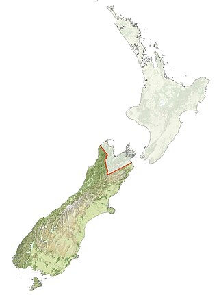
Ngāi Tahu, or Kāi Tahu, is the principal Māori iwi (tribe) of the South Island. Its takiwā is the largest in New Zealand, and extends from the White Bluffs / Te Parinui o Whiti, Mount Mahanga and Kahurangi Point in the north to Stewart Island / Rakiura in the south. The takiwā comprises 18 rūnanga corresponding to traditional settlements. According to the 2018 census an estimated 74,082 people affiliated with the Kāi Tahu iwi.

<span class="mw-page-title-main">Timeline of New Zealand history</span>

This is a timeline of the history of New Zealand that includes only events deemed to be of principal importance – for less important events click the year heading or refer to List of years in New Zealand.

New Munster was an early original European name for the South Island of New Zealand, given by the Governor of New Zealand, Captain William Hobson, in honour of Munster, the Irish province in which he was born.

<span class="mw-page-title-main">Lake Mahinapua</span> Lake in New Zealand

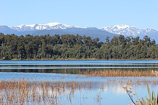
Lake Mahinapua is a shallow lake on the West Coast of New Zealand's South Island. Once a lagoon at the mouth of the Hokitika River, it became a lake when the river shifted its course. Lake Māhinapua was the site of a significant battle between Ngāi Tahu and Ngāti Wairangi Māori, and is regarded by them as a sacred site where swimming and fishing are prohibited. In European times it was part of an inland waterway that carried timber and settlers between Hokitika and Ross until the building of the railway. Today it is protected as a scenic reserve for boating, camping, and hiking.

The history of the Canterbury Region of New Zealand dates back to settlement by the Māori people in about the 10th century.

<span class="mw-page-title-main">New Zealand place names</span> Overview of place names in New Zealand

Most New Zealand place names have a Māori or a British origin. Both groups used names to commemorate notable people, events, places from their homeland, and their ships, or to describe the surrounding area. It is unknown whether Māori had a name for the whole of New Zealand before the arrival of Europeans, but post-colonisation the name Aotearoa has been used to refer to the whole country. Dutch cartographers named the islands Nova Zeelandia, the Latin translation of the Dutch Nieuw Zeeland. By the time of British exploration, the country's name was anglicised to New Zealand.

<span class="mw-page-title-main">Arahura River</span> River in New Zealand

The Arahura River, for a time called the Brunner River after the explorer Thomas Brunner, is a river located on the West Coast of the South Island of New Zealand. In 1846 Brunner and Heaphy sketched and described a Māori settlement they called Araura [sic] (Arahura).

Henare Whakatau Uru was a New Zealand politician. He was the Reform Party Member of Parliament for Southern Maori from 1922 to 1928.

<span class="mw-page-title-main">Local government in New Zealand</span>

New Zealand has a unitary system of government in which the authority of the central government defines sub-national entities. Local government in New Zealand has only the powers conferred upon it by the New Zealand Parliament. In general, local authorities are responsible for enabling democratic local decision-making and promoting the social, economic, environmental, and cultural well-being of their communities, as well as more specific functions for which they have delegated authority.

<span class="mw-page-title-main">Colony of New Zealand</span> British crown colony (1841–1907)

The Colony of New Zealand was a colony of the United Kingdom of Great Britain and Ireland that encompassed the islands of New Zealand from 1841 to 1907. The power of the British Government was vested in the governor of New Zealand. The colony had three successive capitals: Okiato in 1841; Auckland from 1841 to 1865; and Wellington from 1865, which continues as the capital of New Zealand today.

This timeline sets out intertribal battles involving Māori people in what is now New Zealand.

Hana Merenea O'Regan is a Māori language advocate and academic in New Zealand. She is a member of the Ngāi Tahu iwi (tribe).

<span class="mw-page-title-main">Pounamu</span> Hard, green minerals in New Zealand culture

Pounamu is a term for several types of hard and durable stone found in the South Island of New Zealand. They are highly valued in New Zealand, and carvings made from pounamu play an important role in Māori culture.

<span class="mw-page-title-main">Atholl Anderson</span> New Zealand archaeologist

Atholl John Anderson is a New Zealand archaeologist who has worked extensively in New Zealand and the Pacific. His work is notable for its syntheses of history, biology, ethnography and archaeological evidence. He made a major contribution to the evidence given by the iwi (tribe) Ngāi Tahu to the Waitangi Tribunal.

References

  1. "VOGEL, Sir Julius, K.C.M.G.". An Encyclopaedia of New Zealand. Retrieved 26 August 2010.
  2. Ngai Tahu before the Treaty
  3. The Maoris of the South Island
  4. Charlie Gates and John Hartevelt (5 February 2010). "Ngai Tahu reject flag as 'trouble'". The Press . Retrieved 12 November 2011.
  5. A. H. McLintock (ed), An Encyclopaedia of New Zealand", 3 vols, Wellington, NZ:R.E. Owen, Government Printer, 1966, vol 3 p. 526.'
  6. "The Ngai Tahu Report 1991". Archived from the original on 1 March 2010. Retrieved 26 February 2010.
  7. New Leinster, New Munster, and New Ulster
  8. Text of the 1846 Constitution from the [London Gazette]
  9. "Early Constitutions".
  10. Oliver, W.H. (ed) (1981) The Oxford History of New Zealand. Wellington: Oxford University Press (NZ).
  11. "New Zealand - South Island, The South Island and the Constitution". dreamlike.info. Archived from the original on 23 July 2015. Retrieved 21 March 2014.
  12. "Luceo Non Uro". The Daily Southern Cross . Papers Past. 20 January 1865. p. 4. Retrieved 21 March 2014.
  13. A Concise History of New Zealand by Philippa Mein-Smith 2005.
  14. Putting the wind up Archived 31 March 2008 at the Wayback Machine , New Zealand Listener, Vol 204, No 3454, 22–28 July 2006.
  15. "Candidate calls for Southern Assembly | Scoop News".
  16. "Candidates". www.nzfirst.org.nz. Archived from the original on 12 October 2011.
  17. Written submission in support of application for broadcasting funding [ permanent dead link ], Richard Prosser, 18 April 2008
  18. North & South Magazine March 2010
  19. "Counting the changes". The Press . Retrieved 12 November 2011.
  20. "Political Parties' Registration Cancelled | Scoop News".
  21. 1 2 South Island First
  22. "New Zealand's wackiest political parties part 2". TV3. Archived from the original on 16 July 2012.
  23. New Munster Party
  24. http://www.flaginstitute.org/pdfs/John%20Moody.pdf [ bare URL PDF ]
  25. 1 2 Flags of the World's South Island page
  26. New Munster Party Political Images [ permanent dead link ]
  27. "Independent thinking". 10 December 2011.

See also