
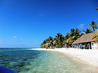
San Pedro is a town on the southern part of the island of Ambergris Caye in the Belize District of the nation of Belize, in Central America. According to the 2015 mid-year estimates, the town has a population of about 16,444. It is the second-largest town in the Belize District and largest in the Belize Rural South constituency. The once sleepy fishing village was granted the status of a town in 1984.

Ambergris Caye, pronounced am-BUR-gris KEE, is the largest island of Belize, located northeast of the country's mainland, in the Caribbean Sea. It is about 40 kilometres (25 mi) long from north to south, and about 1.6 kilometres (1 mi) wide. Where it has not been modified by humans, it is mostly a ring of white sand beach around mangrove swamp in the centre. Though administered as part of the Belize District, the closest point on the mainland is part of the Corozal District.

The Gulf or Bay of Honduras is a large inlet of the Caribbean Sea, indenting the coasts of Belize, Guatemala, and Honduras. From north to south, it runs for approximately 200 km from Dangriga, Belize, to La Ceiba, Honduras.

The Belize Barrier Reef is a series of coral reefs straddling the coast of Belize, roughly 300 meters (980 ft) offshore in the north and 40 kilometers (25 mi) in the south within the country limits. The Belize Barrier Reef is a 300-kilometer (190 mi) long section of the 900-kilometer (560 mi) Mesoamerican Barrier Reef System, which is continuous from Cancún on the north-eastern tip of the Yucatán Peninsula through the Riviera Maya and down to Honduras, making it the second largest coral reef system in the world after the Great Barrier Reef in Australia. It is Belize's top tourist destination, popular for scuba diving and snorkeling and attracting almost half of its 260,000 visitors. It is also vital to the country's fishing industry.

Hol Chan Marine Reserve is a marine reserve close to Ambergris Caye and Caye Caulker, off the coast of Belize. It covers approximately 18 km² (4,448 acres) of coral reefs, seagrass beds, and mangrove forest. Hol Chan is Mayan for "little channel".

Caye Chapel is a small, private island in Belize, 16 miles (26 km) north-northeast of Belize City and 3 miles (4.8 km) south of Caye Caulker. It was once owned by Isaiah Emmanuel Morter, Belize's first African millionaire.
The Caribbean Coral Reef Ecosystems (CCRE) program began with a collaborative field project conceived by six National Museum of Natural History scientists during the early 1970s. The scientists interests included a range of disciplines central to reef ecology, including: invertebrate and vertebrate zoology, botany, carbonate geology, and paleobiology. The primary work site is the Carrie Bow Marine Field Station, a research station at Carrie Bow Caye on the Meso-American Barrier Reef in Belize. The program is an extended duration study of coral reefs, mangroves, sea grass meadows, and the sandy bottoms. It has been a functioning research program since the early 1970s when it was called the Investigations of Marine Shallow-Water Ecosystems (IMSWE).

Tourism in Belize has grown considerably recently, and it is now the second largest industry in the nation. Belizean Prime Minister Dean Barrow has stated his intention to use tourism to combat poverty throughout the country. The growth in tourism has positively affected the agricultural, commercial, and finance industries, as well as the construction industry. The results for Belize's tourism-driven economy have been significant, with the nation welcoming almost one million tourists in a calendar year for the first time in its history in 2012.

Tobacco Caye is a tiny island in Belize, about 10 miles east of Dangriga. It is approximately three acres in area, shaped like an egg, with a north-south dimension of about 240 m (260 yd) and an east-west dimension of 125 metres. It has a permanent population of about 20, and sees a regular stream of travelers thanks to the five small lodges on the island. The island is believed to have been named for the early cultivation of tobacco there. The earliest known European chart to indicate Tobacco Caye was by the British geographer J. Speer in 1771.
Laughing Bird Caye is an island off the coast of Placencia, Belize. On 21 December 1991, Laughing Bird Caye National Park was declared. It is spread over an area of 1.8 acres (0.73 ha). The island is named after a population of laughing gulls which previously bred there.
Janet Gibson is a biologist and zoologist from Belize. She was awarded the Goldman Environmental Prize in 1990 for her efforts on conservation of the marine ecosystems along the Belizean coast, in particular the barrier reef system. The Belize Barrier Reef was granted UNESCO World Heritage status in 1996, through efforts of Gibson and others. She is the current director of the Belize Wildlife Conservation Society.

Bacalar Chico National Park and Marine Reserve (BCNPMR) is a protected area and UNESCO World Heritage Site on the northern part of Ambergris Caye in Belize.

Glover's Reef is a partially submerged atoll located off the southern coast of Belize, approximately 45 kilometres from the mainland. It forms part of the outermost boundary of the Belize Barrier Reef, and is one of its three atolls, besides Turneffe Atoll and Lighthouse Reef.
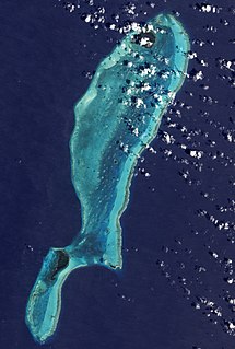
Mexico Rocks is a shallow patch reef complex located off the far northern tip of Ambergris Caye, and is part of the Belize Barrier Reef system in the Caribbean Sea. The site consists of approximately 100 Holocene patch reefs clustered on a Pleistocene ridge of limestone and is composed predominantly of boulder star corals. The reef has accumulated in shallow water, about 2.5 to 5 metres deep, over the last 420 years, under static sea level conditions. The site was recommended for designation as a marine preserve in 1978, and was approved in 2015 as a part of the Hol Chan Marine Reserve. The reef is popular among snorkelers and SCUBA divers, and it is seen as an important addition to Ambergris Caye's ecotourism attractions.

Half Moon Caye is an island and natural monument of Belize located at the southeast corner of Lighthouse Reef Atoll. This natural monument was the first nature reserve to have been established in Belize under the National Park Systems Act in 1981 and first marine protected area in Central America. This is also Belize's oldest site of wildlife protection since it was first designated as a bird sanctuary in 1924 to protect the habitat of the red-footed booby birds.

Gladden Spit and Silk Cayes Marine Reserve (GSSCMR) is a protected marine reserve in the central part of Belize's Barrier Reef. It covers approximately 25,980 acres (10,510 ha) lying 36 kilometres (22 mi) off the coast of Placencia. Established in 2003, The reserve comes under the authority of the government's Fisheries Department, but is managed by the Southern Environmental Association, a community-based organisation.

Turneffe Atoll is located southeast of Ambergris Caye and Caye Caulker, off the coast of Belize in Central America, 20 miles from Belize City. It is one of three atolls of the Belize Barrier Reef, along with Glover's Reef and Lighthouse Reef. It is approximately 30 miles long and 10 miles wide, making it the largest coral atoll in Belize and in the Mesoamerican Barrier Reef System. The atoll was officially declared a marine reserve on November 22, 2012.
Lighthouse Reef is an atoll in the Caribbean Sea, the easternmost part of the Belize Barrier Reef and one of its three atolls, the other two being Turneffe Atoll and Glover's Reef. Lighthouse Reef is located about 80 kilometres (50 mi) southeast of Belize City. The atoll is of oblong shape, approximately 35 kilometres (22 mi) long from north to south, and about 8 kilometres (5.0 mi) wide. It forms a shallow sandy lagoon with an area of 120 square kilometres (46 sq mi) and a depth between 2 to 6 metres deep.
Thatch Caye is an island in Belize, located 9 miles (14 km) off of the coast of Dangriga, about two miles from the Belize Barrier Reef. The 11 acres (4.5 ha) island is near Southwater Caye, Tobacco Caye, Cocoplum Caye, and Fantasy Caye and South Water Caye Marine Reserve.
