
New London County is in the southeastern corner of Connecticut and comprises the Norwich-New London, Connecticut Metropolitan Statistical Area, which is also included in the Hartford-East Hartford, Connecticut Combined Statistical Area. There is no county government and no county seat, as is the case with all eight of Connecticut's counties; towns are responsible for all local government activities, including fire and rescue, snow removal, and schools.

Mystic is a village and census-designated place (CDP) in Groton and Stonington, Connecticut.

Norwich is a city in New London County, Connecticut, United States. The Yantic, Shetucket, and Quinebaug Rivers flow into the city and form its harbor, from which the Thames River flows south to Long Island Sound. The city is part of the Southeastern Connecticut Planning Region. The population was 40,125 at the 2020 United States Census.

C-Tran, more formally the Clark County Public Transit Benefit Area Authority, is a public transit agency serving Clark County, Washington, United States, including the cities of Battle Ground, Camas, Vancouver, Washougal, and Yacolt. Founded in 1981, C-Tran operates fixed route bus services within Clark County, as well as paratransit services for qualified persons with disabilities (C-Van) and a dial-a-ride service in Camas, Ridgefield, and La Center. C-Tran also provides express commuter services between Clark County and various points in Portland, Oregon, including downtown, the Parkrose/Sumner and Delta Park MAX Light Rail stations, Lloyd District, and Oregon Health and Science University. In 2022, the system had a ridership of 4,088,200, or about 14,200 per weekday as of the first quarter of 2023.
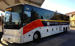
Amtrak Thruway is a system of through-ticketed transportation services to connect passengers with areas not served by Amtrak trains. In most cases these are dedicated motorcoach routes, but can also be non-dedicated intercity bus services, transit buses, vans, taxis, ferry boats and commuter rail trains.
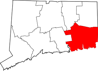
The Southeastern Connecticut region comprises, as the name suggests, the southeastern corner of the state of Connecticut. It is sometimes referred to as New London County or by the tourist slogan Mystic and More.

The New York, Providence and Boston Railroad, normally called the Stonington Line, was a major part of the New York, New Haven and Hartford Railroad between New London, Connecticut and Providence, Rhode Island. It is now part of Amtrak's high-speed Northeast Corridor.

Emeryville station is an Amtrak station in Emeryville, California, United States. The station is served by the California Zephyr, Capitol Corridor, Coast Starlight, and San Joaquins. The station is the primary connection point for Amtrak Thruway buses serving San Francisco.

Connecticut's 2nd congressional district is a congressional district in the U.S. state of Connecticut. Located in the eastern part of the state, the district includes all of New London County, Tolland County, and Windham County, along with parts of Hartford, Middlesex, and New Haven counties. Principal cities include Enfield, Norwich, New London, and Groton.

Interstate 95 (I-95) is the main north–south Interstate Highway on the East Coast of the United States, running in a general east–west compass direction for 111.57 miles (179.55 km) in Connecticut, from the New York state line to the Rhode Island state line. I-95 from Greenwich to East Lyme is part of the Connecticut Turnpike, during which it passes through the major cities of Stamford, Bridgeport, and New Haven. After leaving the turnpike in East Lyme, I-95 is known as the Jewish War Veterans Memorial Highway and passes through New London, Groton, and Mystic, before exiting the state through North Stonington at the Rhode Island border.

Sacramento Valley Station is an Amtrak railway station in the city of Sacramento, California, at 401 I Street on the corner of Fifth Street. It is the seventh busiest Amtrak station in the country, and the second busiest in the Western United States. It is served by four different Amtrak train routes and connecting Amtrak Thruway motorcoaches. It is also the western terminus for the Gold Line of the Sacramento RT Light Rail system and the Route 30 bus serving Sacramento State University.

New London Union Station is a railroad station on the Northeast Corridor located in downtown New London, Connecticut, United States. Union Station is a station stop for most Amtrak Northeast Regional trains and all CTrail Shore Line East commuter rail trains, making it the primary railroad station in southeastern Connecticut. It serves as the centerpiece of the Regional Intermodal Transit Center, with connections to local and intercity buses as well as ferries to Long Island and Fishers Island, New York, and Block Island, Rhode Island. The station has one side platform and one island platform serving the two-track Northeast Corridor; the latter platform also serves a siding track that connects to the New England Central Railroad mainline.

Several neighborhoods of Norwich, Connecticut maintain independent identities and are recognized by official signs marking their boundaries. The following is a list of neighborhoods in Norwich.
The Highway 17 Express is an Amtrak Thruway route provided by a consortium of entities that provides regional service between San Jose and Santa Cruz County in the South Bay of the San Francisco Bay Area. The service is so called because it travels on California State Route 17. It is operated by the Santa Cruz Metropolitan Transit District.

The Salt Lake City Intermodal Hub is a multi-modal transportation hub in Salt Lake City, Utah, United States served by the Blue Line of UTA's TRAX light rail system that operates in Salt Lake County and by the FrontRunner, UTA's commuter rail train that operates along the Wasatch Front with service from Ogden in central Weber County through Davis County, Salt Lake City, and Salt Lake County to Provo in central Utah County. Service at the intermodal hub is also provided by Amtrak, and Greyhound Lines, as well as UTA local bus service.
The Cape Fear Public Transportation Authority, operating as Wave Transit, is the public transportation operator for the metro area of Wilmington, North Carolina. Sixteen regular routes are provided, with all but one running seven days per week. A free downtown shuttle also runs using road trolleys.
Tracer is the public bus system for the city of Tracy, California. Unique among transit agencies, since 2002 the service operates as free public transport every April and December.

Crystal Mall is an enclosed, two-level regional mall in Waterford, Connecticut. It is situated in a central retail area off the Hartford Turnpike, across from a smaller, open-air shopping center, Waterford Commons. The mall covers a gross leaseable area of 782,786 sq ft (72,723 m2), making it Connecticut's ninth largest mall, boasting 110 shops. Its primary trade area includes a trade population of 296,161 people, mostly serving the nearby towns of Waterford, Stonington, Norwich, Groton and New London. It is currently anchored by the traditional chains Christmas Tree Shops and JCPenney while featuring traditional stores including but not limited to Bath and Body Works, Forever 21, Men's Warehouse, Rue 21, Talbot's, and Victoria's Secret.

The Norwich and Westerly Railway was an interurban trolley system that operated in Southeastern Connecticut during the early part of the 20th century. It operated a 21-mile line through rural territory in Norwich, Preston, Ledyard, North Stonington, and Pawcatuck, Connecticut to Westerly, Rhode Island between 1906 and 1922. For most of its length, the route paralleled what is now Connecticut Route 2.

The Southeastern Connecticut Planning Region is a planning region and county-equivalent in Connecticut. It is served by the coterminous Southeastern Connecticut Council of Governments (SCCOG). In 2022, planning regions were approved to replace Connecticut's counties as county-equivalents for statistical purposes, with full implementation occurring by 2024.


