Southern Highlands, Tanzania

Last updated

The Southern Highlands is a highland region in southwestern Tanzania, at the northern end of Lake Malawi. The highlands include portions of Mbeya, Njombe, Rukwa, Ruvuma, and Songwe regions, bordering Malawi, Mozambique, and Zambia. [1] Mbeya is the largest city in the highlands.

Contents

Geography

The highlands comprise a group of plateaus and volcanic mountains, including the Mbeya Mountains, Poroto Mountains, Kipengere Range, Mount Rungwe, Kitulo Plateau, Umalila Mountains, and Matengo Highlands. The Ufipa Plateau extends northwest, between Lake Tanganyika and Lake Rukwa. [2] The eastern and western branches of the East African Rift converge in the highlands, and the Western Rift continues south as the valley of Lake Malawi. To the northeast, the Makambako Gap separates the Southern Highlands from the Eastern Arc Mountains. [3]

Lake Ngozi in the Poroto Mountains. Lake Ngozi, Tanzania (2464101174).jpg
Lake Ngozi in the Poroto Mountains.

Mt. Rungwe (2,960 metres), and Mtorwe (2961 m) in the Kipengere Range, are the highest peaks in the highlands. Other peaks include Chaluhangi (2933 m) and Ishinga (2688 m) in the Kipengere Range, Ngozi (2621 m) in the Poroto Mountains, and Mbeya (2826 m), Loloza (2656 m), and Pungulomo (2273 m) in the Mbeya Mountains. [4]

The northern and eastern slopes of the Mbeya Mountains and the eastern portion of the Ufipa Plateau drain into the closed basin of Lake Rukwa. The Great Ruaha River, a tributary of the Rufiji River, drains the eastern slopes of the Mbeya and Kipengere mountains.

Rivers flowing into Lake Malawi drain the southern portion of the highlands. The Songwe River drains the western and southern Umalila Mountains, and forms the boundary between Tanzania and Malawi. The Kiwira River drains the east slope of the Umalila Mountains, south slope of the Poroto Mountains, and western slope of Mount Rungwe. The Lufilyo River drains the east slope of Mount Rungwe and the Livingstone Forest in Kitulo National Park. A number of smaller streams descend the steep western escarpment of the Kipengere Range and western Matengo Highlands. The Ruhuhu River drains the southern portion of the Kipengere Range and northern Matengo Highlands.

The eastern slopes of the Matengo Highlands drain into the Ruvuma River.

Climate

Rainfall ranges from 823 mm on the Ufipa Plateau up to 2,850 mm on the slopes of Mount Rungwe and the Livingstone and Poroto mountains facing Lake Malawi. Rainfall is mostly during the November through April wet season, although higher elevations experience mists and light rain during the May through August dry season. Rainfall comes from convective thunderstorms that form over Lake Malawi, and the slopes facing towards lake are generally wetter. The highlands are cooler than the surrounding lowlands, with annual temperatures between 13 °C and 19 °C. The highest elevations experience regular nighttime frosts between June and August. [5]

Ecology

The Southern Highlands are covered with grasslands, savannas, woodlands, and forests. Miombo woodland and savanna predominates at lower elevations. At higher elevations the mountains are home to Afromontane evergreen forests, grasslands, and shrublands, part of the Southern Rift montane forest-grassland mosaic ecoregion, which extends into the nearby mountains of Malawi and Zambia. [6]

The highlands are home to several protected areas, including Kitulo National Park, Mpanga-Kipengere Game Reserve, Mount Rungwe Nature Forest Reserve, [7] and forest reserves.

Transport

Tanzania's A104 highway connects Mbeya with Tanzania's capital Dodoma, and continues west from Mbeya to Tunduma on the Zambian border. The TAZARA Railway parallels the A104 through the highlands.

Related Research Articles

Eastern Highlands mountain range in Zimbabwe and Mozambique

The Eastern Highlands, also known as the Manica Highlands, is a mountain range on the border of Zimbabwe and Mozambique. The Eastern Highlands extend north and south for about 300 kilometres (190 mi) through Zimbabwe's Manicaland Province and Mozambique's Manica Province.

Mbeya City in Tanzania

Mbeya is a city located in southwest Tanzania, Africa. Mbeya's urban population was 385,279 according to the 2012 census. Mbeya is the capital of the surrounding rural Mbeya region.

The Kipengere Range, also known as the Livingstone Mountains, lies entirely in Njombe Region in southwest Tanzania at the northern end of Lake Nyasa. Near Lake Nyasa they are known as the Kinga Mountains. It is a plateau-like ridge of mountains running southeastwards from the basin of the Great Ruaha River in the north to that of the Ruhuhu River in the south, and forms part of the eastern escarpment of the East African Rift. The range is mostly clad in montane grasslands, renowned for their botanical diversity and displays of flowers, with montane evergreen forests mostly in stream valleys.

Udzungwa Mountains Mountain range in south-central Tanzania

The Udzungwa Mountains are a mountain range in south-central Tanzania. The mountains are mostly within Iringa Region, south of Tanzania's capital Dodoma. The Udzungwa Mountains are part of the Eastern Arc Mountains, and are home to a biodiverse community of flora and fauna with large numbers of endemic species.

The Kirk Range is a plateau in southwestern Malawi, extending in a north-south direction and skirting the southwestern shore of Lake Malawi and the western border of the Shire River valley. The range includes several peaks higher than 1800 meters in elevation. The northern end of the range overlooks the Central Region plateau and Lake Malawi. The range forms the Malawi-Mozambique border, and the divide between the watersheds of Mozambique's Revúboé River to the west and Malawi's Shire River to the east. The Lisungwe and Mkulumadzi (Wamkulumadzi) rivers are tributaries of the Shire that originate in the Kirk Range.

Afromontane Subregion of the Afrotropical realm

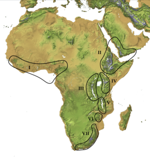
The Afromontane regions are subregions of the Afrotropical realm, one of the Earth's eight biogeographic realms, covering the plant and animal species found in the mountains of Africa and the southern Arabian Peninsula. The Afromontane regions of Africa are discontinuous, separated from each other by lower-lying areas, and are sometimes referred to as the Afromontane archipelago, as their distribution is analogous to a series of sky islands.

Mount Rungwe


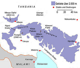
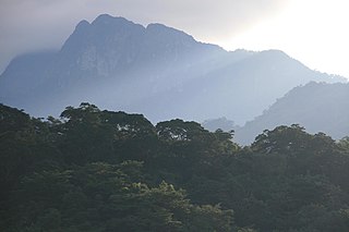
Mount Rungwe is a volcanic mountain in Mbeya Region, in Tanzania's Southern Highlands. At an altitude of 2,981 metres (9,780 ft), it is southern Tanzania's second-highest peak. Rungwe's volcano is currently inactive.

Tukuyu Town in Rugwe District, Mbeya Region, Tanzania

Tukuyu, known as Neu Langenburg during the German colonial rule, is a small hillside town that lies about 36 miles (58 km) south of the city of Mbeya, at an elevation of around 5,000 ft (1,500 m) in the highland Rungwe District of southern Tanzania, East Africa. Tukuyu town has a moderate to cool temperature ranging from 10° C in May/June to mid 20°C in around November. The town and surrounding areas are green all year round due to the almost year-round convectional rains resulting from Lake Nyasa(Lake Malawi).Tukuyu town is divided into several wards include; Kawetere, Msasani, Bulyaga and Bagamoyo.

South Malawi montane forest–grassland mosaic

The South Malawi montane forest-grassland mosaic is an ecoregion of Malawi.

The Poroto Mountains are a mountain range in the Mbeya Region of Tanzania. They are located east of the city of Mbeya. The Poroto Mountains are a northwestward extension of the Kipengere Range, and part of the Southern Highlands. The Poroto mountains are volcanic in origin, part of the geological Rungwe Volcanic Province.

Kitulo National Park

(TANAPA))

Mbeya Range is a volcanic mountain range in Mbeya Region, in southwestern Tanzania, East Africa. It forms an arc just north of the town of Mbeya and includes Loleza Peak, Mbeya Peak, Nyanuwa Peak, and Pungulumo. The range is at the junction of the eastern Gregory Rift and western Albertine Rift valleys. and is in Rungwe volcanic province. The Songwe Scarp terminates the Rukwa Trough at its southeast end and forms the northwestern side of the Mbeya Range.

Southern Rift montane forest–grassland mosaic

The South Malawi montane forest-grassland mosaic is a montane grasslands and shrublands ecoregion of Tanzania, Malawi, Mozambique, and Zambia.

The Misuku Hills are a mountain range in Malawi's Northern Region.

The Ufipa Plateau is a highland in southwestern Tanzania. It lies mostly in Rukwa Region, near the border with Zambia. The plateau is named for the Fipa people who inhabit it.

Umalila Mountains Mountain range in Tanzania

The Umalila Mountains are a mountain range in southern Tanzania, on the border with Malawi. The Umalila Mountains are part of Tanzania's Southern Highlands.

The Rungwe dwarf galago is a newly-identified species of eastern dwarf galago. Specimens were first collected in the 1930s, but were identified as different species. A formal description of the species is presently being made.

Njesi Highlands Mountain range in Mozambique

The Njesi Highlands are a range of mountains in northern Mozambique.

References

  1. Rasmussen, Torben (1986). "The Green Revolution in the Southern Highlands". In Jannik Boesen (ed.). Tanzania: Crisis and Struggle for Survival. Nordic Africa Institute. p. 191. ISBN   91-7106-257-2.
  2. "Southern Rift montane forest-grassland mosaic". World Wildlife Fund ecoregion profile. Accessed 3 September 2019.
  3. Ara Monadjem, Peter J. Taylor, Christiane Denys, Fenton P.D. Cotterill (2015). Rodents of Sub-Saharan Africa: A biogeographic and taxonomic synthesis. Walter de Gruyter GmbH & Co KG, 2015. pg. 900
  4. Watson, Graeme (1995). "Tanzania's Other Mountains". The Alpine Journal. Accessed 2 September 2019.
  5. "Southern Rift montane forest-grassland mosaic". World Wildlife Fund ecoregion profile. Accessed 3 September 2019.
  6. "Southern Rift montane forest-grassland mosaic". World Wildlife Fund ecoregion profile. Accessed 3 September 2019.
  7. "Mount Rungwe Nature Forest Reserve". Tanzania Forest Services Agency. Accessed 4 September 2019.

Bibliography

Latham, P. (2008) Plants visited by bees and other useful plants of Umalila, southern Tanzania DFID. ISBN   978-0955420832

Coordinates: 9°10′00″S34°31′00″E / 9.1667°S 34.5167°E / -9.1667; 34.5167