The Southern Patagonian ice field dispute is a border dispute between Argentina and Chile over the delineation of the boundary line between the two countries on the Southern Patagonian Ice Field,[1][2][3] a large expanse of glaciers located in the Patagonian Andes, which is the largest non-polar continental ice field with land access. It is called continental ice in Argentina and southern ice field in Chile, to differentiate it from the northern ice field. As of 2024,[4][5][6] the Argentine-Chilean border in this sector is still pending of definition according to the 1998 agreement signed by both countries.[7] The original border was defined 100 years prior on October 1st, 1898 by experts from both countries.[8][9][10]
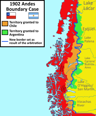
Map of the 1902 award between Argentina and Chile in the area of the Southern Patagonian Ice Field (which wasn't affected by it).Argentine map of 1912 showing historical boundary markers agreed upon by the Argentine and Chilean experts, Fitz Roy, Huemul, Campana, Agassiz, Heim, Mayo and Stokes.
The boundary between Chile and the Argentine Republic is, from North to South, up to the fifty-second parallel of latitude, the Andes Mountain Range. The boundary line shall run in that extension along the highest peaks of said Cordillera dividing the waters, and shall pass between the slopes that break off on one side and the other. The difficulties that may arise due to the existence of certain valleys formed by the bifurcation of the Cordillera and where the dividing line of the waters is not clear, shall be resolved amicably by two experts appointed, one from each party. In case they do not reach an agreement, a third Expert appointed by both Governments shall be called upon to decide them. Of the operations carried out by them, a record shall be drawn up in duplicate, signed by the two Experts, on the points on which they have agreed, and also by the third Expert on the points decided by him. These minutes shall take full effect as soon as they have been signed by them and shall be considered firm and valid without the need for any other formalities or formalities. A copy of the minutes shall be sent to each of the Governments.[12]
On August 20, 1888, an agreement was signed to carry out the demarcation of the limits according to the 1881 treaty, appointing the experts Diego Barros Arana for Chile and Octavio Pico Burgess for Argentina.[13] In 1892 Barros Arana presented his thesis according to which the 1881 Treaty had fixed the limit in the continental divortium aquarum, which was rejected by the Argentine expert.[14]
Experts have shown that it is always convenient to take the mountain as a support for the boundary and not the watershed. Rey Balmaceda tells an anecdote of Perito Moreno, who diverted the course of the Fénix River, with the help of a crew of laborers, so that it would stop heading towards the Pacific and would swell the waters of the Deseado River. With this Moreno wanted to demonstrate that the true basis for drawing a solid and efficient line is the mountains and not the course of the waters.[15]
Because differences arose on several points of the border on which the experts could not agree, the demarcation was suspended in February 1892, until the Boundary Protocol between Chile and Argentina 1893 was subscribed, which in its article 1 provides:
Article One of the Treaty of July 23, 1881, stipulating that "the boundary between Chile and the Argentine Republic is from North to South up to the 52nd parallel of latitude, the Andes Cordillera", and that "the boundary line shall run along the highest peaks of the said Cordillera, dividing the waters, and that it shall pass between the slopes that break off on either side", the Experts and the Sub-Commissions shall have this principle as the invariable rule of their proceedings. Consequently, all lands and all waters, namely: lakes, lagoons, rivers and parts of rivers, streams and slopes east of the line of the highest peaks of the Andes Mountains dividing the waters, shall be considered in perpetuity as property and absolute domain of the Argentine Republic, and all lands and all waters, namely: lakes, lagoons, rivers and parts of rivers, streams and slopes east of the highest peaks of the Andes Mountains dividing the waters, shall be considered as property and absolute domain of Chile: lakes, lagoons, rivers, and parts of rivers, streams, slopes, which are found to the west of the highest peaks of the Andes Mountains that divide the waters.[16]
This protocol is of particular importance, as the retreat of the glaciers could allow Pacific fjords to penetrate into Argentine territory.[17]
In January 1894 the Chilean expert declared that he understood that the main chain of the Andes was the uninterrupted line of peaks that divide the waters and that form the separation of the basins or tributary hydrographic regions of the Atlantic to the east and the Pacific to the west. The Argentine expert Norberto Quirno Costa (Pico's replacement) replied that they had no authority to define the meaning of the main chain of the Andes as they were only demarcators.[14]
In April 1896, the Agreement to facilitate territorial delimitation operations was signed, which appointed the British monarch to arbitrate in case of disagreements. In the minutes of October 1, 1898, signed by Barros Arana and Francisco Pascasio Moreno (Quirno Costa's replacement, who resigned in September 1896) and by his assistants Clemente Onelli (from Argentina) y Alejandro Bertrand (from Chile), the experts:
agree with the points and stretches indicated (...) 331 and 332 (...), resolve to accept them as forming part of the dividing line (...) between the Republic of Argentina and the Republic of Chile (...). (...) between the Republic of Argentina and the Republic of Chile (...)
On the attached map, point 331 is Mount Fitz Roy and 332 is Mount Stokes, both being agreed as boundary markers, although the former is not on the watershed and was taken as a natural landmark. As the experts did not access the area, they established the caveat that if the geographical principle did not run where they had supposed it did, there could be modifications.[15]
When the experts could not agree on different stretches of the border, it was decided in 1898 to resort to Article VI paragraph 2 of the 1881 Boundary Treaty and request Queen Victoria of the United Kingdom for an arbitration ruling on the issue, who appointed three British judges. In 1901, one of the judges, Colonel Thomas Holdich, traveled to study the disputed areas.[18]
The Argentine government argued that the boundary should essentially be an orographic boundary along the highest peaks of the Andes Mountains and the Chilean government argued for a continental watershed. The tribunal considered that the language of the 1881 treaty[19] and the 1893 protocol was ambiguous and susceptible to various interpretations, the two positions being irreconcilable. On May 20, 1902 King Edward VII issued the sentence which divided the territories of the four disputed sections within the boundaries defined by the extreme claims on both sides and appointed a British officer to demarcate each section in the summer of 1903. The award did not issue on the ice field, for in its article III it sentenced:
From Mount Fitz Roy to Mount Stokes the boundary line has already been determined.[20]
The award thus considered that in that area the high peaks are water dividing and therefore there was no dispute. Both experts, Francisco Pascasio Moreno from Argentina and Diego Barros Arana from Chile agreed on the border between Mount Fitz Roy and Stokes.[21] Since 1898, the demarcation of the border in the ice field, between the two mountains, was defined on the next mountains and their natural continuity: Fitz Roy, Torre, Huemul, Campana, Agassiz, Heim, Mayo and Stokes.[8][9][10] In 1914 the Mariano Moreno range was visited by an expedition, however, Francisco Pascasio Moreno already knew of its existence.[22]
Demarcation
Territorial dispute between Chile and Argentina over the Southern Patagonian Ice Field before 1994The polygonal boundary proposed in 1991.
In 1941, the protocol regarding the repositioning of milestones on the Argentine-Chilean border was signed, creating the Joint Commission on Boundaries (COMIX), formed by technicians from both countries. These technicians were to be in charge of demarcating the border on the basis of the criteria established by the 1881 treaty and the 1893 protocol.[17]
On August 29, 1990, Presidents Carlos Saúl Menem and Patricio Aylwin signed the Santiago Declaration, which instructed the Joint Boundary Commission to accelerate demarcation work and issue a report on pending demarcation issues.[23]
On September 12, 1990, the Joint Commission, through Minute No. 132, defined the 24 points that remained to be demarcated on the border. On February 10 and 12, 1990, the Commission met in Punta Arenas, resolving 22 of the 24 areas not yet demarcated.[17]
In Chile it was argued that the experts identified in 1898 as intermediate summits between the Fitz Roy and Stokes mounts: Torre, Huemul, Campana, Murallón, Bertrand, Roma, Bolados, Peineta and Mayo. The Stokes of 1898 was considered to be the Cervantes. Giving definitive character to what they saw according to the techniques and knowledge of their time. With a chart of the Military Geographic Institute of 1972 at a scale of 1:50,000, they determined that the line should be drawn from the Fitz Roy by: Adela range (Torre, Ñato and Grande hills), Doblado, Huemul, Campana, Murallón, Cono, Bertrand, Roma, Oasis, Bolados, Peineta, Mayo, Cervantes, Piedrabuena range, Cubo and from there to the Daudet.[17]
In Argentina it was argued that the demarcation should be made along the highest peaks dividing waters, as agreed in 1881 and with the most modern techniques available to determine it. Taking as a reference 6 charts of the National Geographic Institute made between 1981 and 1991 at a scale of 1:100,000, they determined that the line should be drawn from Fitz Roy to a point on the Mariano Moreno range, from where the criterion of the highest peaks dividing waters is followed by the following hills: Murallón, Torino, Agassiz, Bolados, Onelli Central, a peak of 2. 130 m, Malaspina range, the two hills Inmaculados, Dos Codos range, Pietrobelli range, a hill of the Piedrabuena range, Cubo and Stokes.[17]
The Murallón and Bolados hills were the only two points in common of both intended routes.
On August 2, 1991, Presidents Menem and Aylwin signed an agreement to draw a polygonal line to equitably divide the disputed territory from Mount Fitz Roy to Mount Stokes,[24] leaving aside what had been agreed upon in 1881 and 1893.
The polygonal line began at Fitz Roy, continued in a straight line westward to an unnamed point (2584 m high), then crossed the Viedma glacier to Mount Puntudo and continued through Torino, Roma, Inmaculado, Dos Picos, Teniente Feilberg, Gemelo, Stokes and Daudet. All the points were connected by straight lines.[17]
In his presentation to the congress on February 27, 1992, the Argentine minister Guido Di Tella argued that the polygonal shape had been agreed upon because of the geophysical impossibility to determine where the high peaks that divide waters are located.[17]
The ruling made the Circo de los Altares Chile's only access to Mount Fitz Roy.
In 1994 the Laguna del Desierto dispute was solved which involved territory of the Ice Field, an international tribunal awarded almost the whole zone to Argentina.[25][26] After a refused appeal in 1995, Chile accepted the award. Since then, Chile has a small corridor to access Mount Fitz Roy and the Marconi Pass was defined as an international border crossing point.
Agreement
This map shows section A and B of the agreement.The area of Laguna Escondida is a point where the boundary would be in such a way that Argentina is 8 kilometers approximately from the Pacific Ocean.
On December 16, 1998, the Agreement was signed to specify the route of the boundary from Mount Fitz Roy to Mount Daudet[27] to replace the proposed polygonal line.[23][28] The agreement maintains what was signed in the 1881 Treaty, high peaks that divide waters and respects the continental watershed, except in some sectors where straight lines are drawn. It also maintains access for Chile to Mount Fitz Roy, and for Argentina to Mount Stokes.[5]
The territory covered by the Agreement is divided into two sectors:
Section A: from Murallón Hill to Daudet Hill. The boundary line is determined as follows: starting from Murallón Hill, the line follows the watershed that passes through Torino East, Bertrand-Agassiz North, Agassiz South, Bolados, Onelli Central, Spegazzini North and Spegazzini South. Then the line continues by straight line segments joining, successively, the points marked with the letters A, B, C, D, E, F, F, G, H, I and J. Between J and K it follows the watershed, then by straight lines joining points L and M. It continues along the watershed to N, from where it continues along the watershed through the hills Pietrobelli, Gardener, Cacique Casimiro and point Ñ. Then by a straight line it reaches point O and by another straight line it reaches Teniente Feilberg hill, continues along the watershed up to point P, from where by straight line segments it reaches point Q, Stokes hill, points R, S, T and Daudet hill, where it ends its route.[29]
Section B: from the summit of Mount Fitz Roy to Cerro Murallón. From the summit of Mount Fitz Roy the line will descend along the watershed to a point at coordinates X=4,541,630 Y=1,424,600. From there it will continue in a straight line to a point located at coordinates X=4,540,950 Y=1,421,200. Then the line will follow the parallel of the site to the West and will be drawn in accordance with the Protocol on Replacement and Placement of Landmarks on the Chilean-Argentine Border of April 16, 1941 and in the Plan of Work and General Provisions governing the Chile-Argentine Joint Boundary Commission.
In the area determined between the parallels of South Latitude 49º10'00" and 49º47'30" and the meridians of West Longitude 73º38'00" and 72º59'00", the Chile-Argentina Joint Boundary Commission must draw up a chart at a scale of 1:50,000 in order to demarcate the boundary, in that sector the Additional Specific Protocol on Shared Water Resources of August 2, 1991 will not be applied.[30] This sector corresponds to a rectangular territory that goes from a few kilometers north of the summit of Mount Fitz Roy to Mount Murallón, in which there is an area without boundary demarcation. Within this area, however, the agreement itself demarcated the boundary from Fitz Roy to a few kilometers to the southwest (point B), and from the same mountain to the north it was defined by means of the 1994 Laguna del Desierto arbitration award.[31][32][33][34][35]
It was agreed that all waters flowing into and out of the Santa Cruz River shall be considered for all purposes as a water resource belonging to the Republic of Argentina. Likewise, the waters flowing towards the oceanic fjords shall be considered for all purposes as water resources belonging to the Republic of Chile, each Party committing itself not to alter, in quantity and quality, the exclusive water resources corresponding to the other Party.[5]
María Teresa Infante Caffi and José Miguel Insulza were some of the main promoters of the agreement within Chile.
Pending border definition area
Boundary of the Southern Patagonian Ice Field shown on official Chilean cartography. The boundary agreed upon in the 1998 Agreement is shown and the pending area is specified.
Boundary of the Southern Patagonian Ice Field shown in the current official Argentine cartography. Nothing of what was established in 1998 by both countries is shown.
Boundary of the Southern Patagonian Ice Field according to official Chilean cartography prior to 1994.
In February 2006 Ricardo Lagos[36] appeared in a photo with the head of the Air Force, General Osvaldo Sarabia, in the undefined border area, this caused controversy with Argentina.[37]
In 2006, the Argentine Instituto Geográfico Militar (IGM) (today Instituto Geográfico Nacional) edited a map without a note about the undefined border but showed the Argentine claims as the official borderline. After Chilean diplomatic protests, the Argentine government withdrew the map temporally and urged Chile to expedite the "demarcation" of the international border according to the 1998 agreement.
The Joint Commission on Boundaries that was entrusted by the Agreement to carry out the geographic studies and draw up the 1:50000 scale chart, an essential requirement to carry out the demarcation on the ground, had not yet been formed as of August 30 of the same year. On that date the chancelleries of both countries issued communiqués, the communiqué of the Argentine Chancellery stating that:[38]
In view of the statements made in a press release issued by the Chilean Ministry of Foreign Affairs today regarding the "Agreement between the Republic of Argentina and the Republic of Chile to specify the route of the boundary from Mount Fitz Roy to Mount Daudet" of December 16, 1998, the Argentine Ministry of Foreign Affairs takes note of Chile's interest in complying with the above-mentioned Agreement and recalls the invitation extended by the Argentine Boundary Commission to its Chilean counterpart by letter sent on February 16, 2006, to demand compliance with it, the Argentine Ministry of Foreign Affairs takes note of Chile's interest in complying with the aforementioned Agreement and recalls the invitation extended by the Argentine Boundary Commission to its Chilean counterpart by letter sent on February 27, 2006 to demarcate the boundary whose route is fully specified in that instrument. Not having received to date no response from Chile to the aforementioned invitation, this Ministry of Foreign Affairs has instructed the Argentine International Boundary Commission to reiterate to its counterpart the need to begin the demarcation work as soon as possible and to propose the implementation of the first tasks necessary for this purpose.
The exchange of communiqués had occurred due to the Chilean government's complaint regarding the non-use of the rectangle of the undefined border area on maps of the Argentine Secretariat of Tourism.[39][40] On August 24, 2006, the Argentine Undersecretary of Tourism stated that the maps used by the Secretariat of Tourism's website were official because they were approved by the Military Geographic Institute of Argentina (and are still used to this day).[41][42][43][44][45]
In the maps published in Argentina, until today, the region continues to be shown without the white rectangle, as can be seen in a map of Santa Cruz on a website of an official Argentine agency.[48] While in the official Chilean maps and most tourist maps, the rectangle is shown and it is clarified that the boundary is not defined according to the 1998 treaty.[49][50][51]
Newspaper reports indicate that on January 8, 2008, daily flights began in Argentine Army helicopters, based in El Chaltén, with personnel from the National Geographic Institute to carry out the geographic surveys necessary to draw up the map prescribed in the Agreement.[52] Reports indicate that Chilean personnel acted as overseers, while the Chilean Army performed similar tasks in other sectors.[53] Technicians of both countries worked on the definition of the border.[54]
In 2006[37] and 2010 the Argentine Foreign Ministry pressured to solve the dispute.[55][56]
In 2018, Argentina made a National Ice Inventory in which are included some disputed glaciers.[57][58][59][60][61] From September 20 to October 4 of the same year, the Argentine army traveled to into the area that is pending to be definition. This caused controversy mainly in Chile[62] where the mayor of Villa O'Higgins denounced the fact as a "provocation" and made a call to the central government of Chile to reinforce the sovereignty in the zone.[6][63]
After the Argentine government published its inventory of glaciers including undefined territory the Chilean Foreign Ministry informed that a claim note had already been sent denying the Argentine inventory.[64]
In 2021, the Chilean president, Sebastián Piñera, authorized the chart SHOA N° 8 not to showing the rectangle in the non-defined zone and expresses the continental shelf claimed by Chile in the Sea of the Southern Zone. Until before the enacted decree, and also after it, on official Chilean maps and also on tourist maps, Chilean maps show a rectangle clarifying that the boundary was not defined according to the 1998 agreement. In the map of Piñera's decree of August 23 of that year, it was not shown as such and the cartography prior to 1998 was used. Both countries consider that they have about a thousand kilometers more ice than the other, which is reflected in the cartographic difference.[65][66]
The same year there was a controversy since CONAF (from Chile) installed a dome in the Circo de los Altares which its southern part is claimed by both countries.[67]
As of 2024, the new border definition is still pending between the line near Mount Fitz Roy and Murallón.[4][5][6][68]
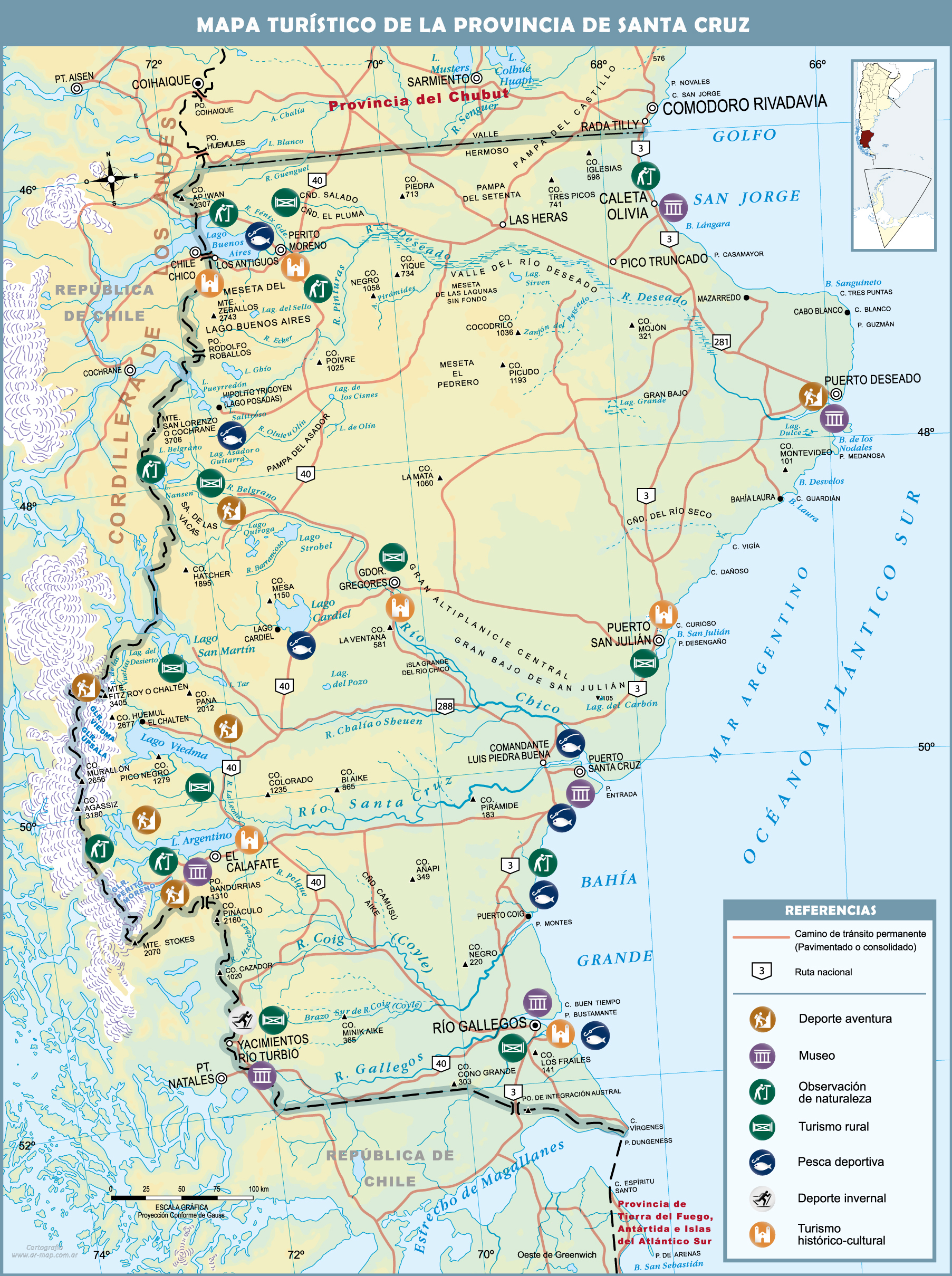
Santa Cruz Province is a province of Argentina, located in the southern part of the country, in Patagonia. It borders Chubut Province to the north, and Chile to the west and south, with an Atlantic coast on its east. Santa Cruz is the second-largest province of the country, and the least densely populated in mainland Argentina.
Los Glaciares National Park is a federal protected area in Santa Cruz Province, Argentina.
The Perito Moreno Glacier is a glacier located in Los Glaciares National Park in southwest Santa Cruz Province, Argentina, and originated in the Magallanes Region in Chile. It is one of the most important tourist attractions in the Argentine Patagonia.
An ice field is a mass of interconnected valley glaciers on a mountain mass with protruding rock ridges or summits. They are often found in the colder climates and higher altitudes of the world where there is sufficient precipitation for them to form. The higher peaks of the underlying mountain rock that protrude through the icefields are known as nunataks. Ice fields are larger than alpine glaciers, but smaller than ice caps and ice sheets. The topography of ice fields is determined by the shape of the surrounding landforms, while ice caps have their own forms overriding underlying shapes.
Monte Fitz Roy is a mountain in Patagonia, on the border between Argentina and Chile. It is located in the Southern Patagonian Ice Field, near El Chaltén village and Viedma Lake. It was first climbed in 1952 by French alpinists Lionel Terray and Guido Magnone.
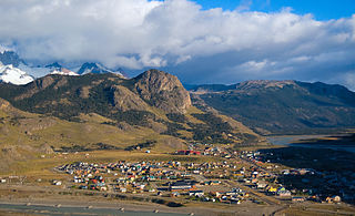
El Chaltén is a small mountain village in Santa Cruz Province, Argentina. It is located on the riverside of Rio de las Vueltas, within the Los Glaciares National Park near the base of Cerro Torre and Cerro Fitz Roy spires, both popular for climbing. It is 220 km north of El Calafate. It is also a popular base for hiking numerous trails, such as those to the base of surrounding peaks and glacial lakes, such as Laguna Torre and Laguna de los Tres.
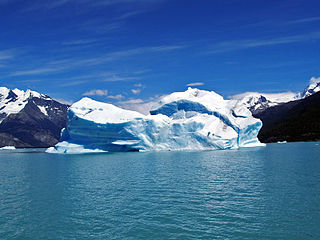
The Southern Patagonian Ice Field, located at the Southern Patagonic Andes between Chile and Argentina, is the world's second largest contiguous extrapolar ice field. It is the bigger of two remnant parts of the Patagonian Ice Sheet, which covered all of southern Chile during the last glacial period, locally called the Llanquihue glaciation.
International relations between the Republic of Chile and the Argentine Republic have existed for decades. The border between the two countries is the world's third-longest international border, which is 5,300 km (3,300 mi) long and runs from north to south along the Andes mountains. Although both countries gained their independence during the South American wars of liberation, during much of the 19th and the 20th century, relations between the countries were tense as a result of disputes over the border in Patagonia. Despite this, Chile and Argentina have never been engaged in a war with each other. In recent years, relations have improved. Argentina and Chile have followed quite different economic policies. Chile has signed free trade agreements with countries such as China, the United States, Canada, South Korea, as well as European Union, and it's a member of the APEC. Argentina belongs to the Mercosur regional free trade area. In April 2018, both countries suspended their membership from the UNASUR.
Dickson Lake is a glacier lake in southern Patagonia located in the Southern Patagonian Ice Field, which since 1998 has been transformed into an international lake as it is crossed by the international boundary between Argentina and Chile due to the retreat of the Dickson glacier. Until that year, Dickson Lake was entirely within Chilean territory, at the northern end of the Torres del Paine National Park in the Magallanes y la Antártica Chilena Region, but it was unified with a lake that began to form in the 1980s by defrosting the melting of the Dickson, Cubo and Frías glaciers. That lake was on the Argentine side when the Agreement was signed to specify the route of the limit from Mount Fitz Roy to the Daudet Hill of 1998, in a sector adjacent to the Los Glaciares National Park, but without being part of it. The lake is fed by the glacier that shares its name and is drained by the Paine River. It receives the waters of Los Perros River, which starts at a proglacial lake that was formed during the retreat of Los Perros Glacier.
On 22 July 1971 Salvador Allende and Alejandro Lanusse, the Presidents of Chile and Argentina, signed an arbitration agreement. This agreement related to their dispute over the territorial and maritime boundaries between them, and in particular the title to the Picton, Nueva and Lennox islands near the extreme end of the American continent, which was submitted to binding arbitration under the auspices of the United Kingdom government.
Tortel is a Chilean commune located at the outflow of the Baker River and Pascua River to the Pacific Ocean. It lies between the Northern and Southern Patagonian Ice Field in the Capitán Prat Province in the Aysén Region. The commune is administered by the municipality in Caleta Tortel, the principal settlement.
The Treaty of Peace and Friendship of 1984 between Chile and Argentina was signed into agreement at the Vatican on 29 November 1984.
The Boundary Treaty of 1881 between Argentina and Chile was signed on 23 July 1881 in Buenos Aires by Bernardo de Irigoyen, for Argentina, and Francisco de Borja Echeverría, for Chile, with the aim of establishing a precise border between the two countries based on the uti possidetis juris principle. Despite dividing largely unexplored lands, the treaty laid the groundwork for nearly all of Chile's and Argentina's 5600 km current border.
The 1902 Arbitral award of the Andes between Argentina and Chile was a British arbitration in 1902 that established the present-day boundaries between Argentina and Chile. In northern and central Patagonia, the borders were established between the latitudes of 40° and 52° S as an interpretation of the Boundary treaty of 1881 between Chile and Argentina.
Argentine irredentism refers to the idea that Argentina has suffered large territorial losses early in the 19th century to neighboring countries, and that it must strive to regain control of them, forming "Great Argentina", envisioned with the same borders as the Viceroyalty of the Río de la Plata. This idea surged in popularity in the late 19th century, and peaked in influence in the late 1940s and early 1950s. All of these claims have been abandoned by Argentina, save for the Falkland Islands sovereignty dispute.
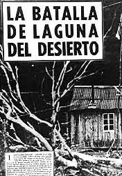
The Laguna del Desierto incident occurred between four Chilean Carabineros and between 40 and 90 members of the Argentine National Gendarmerie and took place in an area south of O'Higgins/San Martín Lake on 6 November 1965, resulting in one lieutenant killed and a sergeant injured, both members of Carabineros, creating a tense atmosphere between Chile and Argentina.
The Argentina–Chile border is the longest international border of South America and the third longest in the world after the Canada–United States border and the Kazakhstan–Russia border. With a length of 5,308 kilometres (3,298 mi), it separates Argentina from Chile along the Andes and on the islands of Tierra del Fuego. However, there are some border disputes, particularly around the Southern Patagonian Ice Field. It is the largest border of the two countries, beating the Argentina–Paraguay and Chile–Bolivia, Argentina's and Chile's second largest borders, respectively.
Del Desierto Lake or Lake of the Desert is a natural lake located in the Lago Argentino Department, Santa Cruz Province, Argentina. Located near Monte Fitz Roy and the O'Higgins/San Martín Lake, Lago del Desierto was for many decades the subject of a territorial dispute between Argentina and Chile, escalating to a small firefight on 6 November 1965 when 40 to 90 members of the Argentine Gendarmerie fought against four Chilean Carabineros, of which a lieutenant was killed and a sergeant was injured. The dispute was resolved favourably for Argentina in 1994 by international arbitration.
The Circo de los Altares is a geological formation of the Patagonian Andes, located in the Southern Patagonian Ice Field, where Mount Torre and Mount Fitz Roy can be seen from its western sides. It is located within the Area in dispute between Chile and Argentina with the border being defined in the northern area of the site.
The Chaltén Mountain Range Natural Site is a natural site part of the Bernardo O'Higgins National Park in the Magallanes and Chilean Antarctica Region, Chile. It is located between the boundary demarcated by the 1994 arbitration award and section B of the 1998 agreement between Argentina and Chile. It has an area of 768 hectares.
↑ Karen I. Manzano Iturra (2019). "SOUTHERN ICE FIELDS. CONTROVERSIES ABOUT THE CHILEAN–ARGENTINIAN FRONTIER (1990-2012)". Revista "Política y Estrategia". 134. Within the neighborhood borders, Chile and Argentina have held several border disagreements, most of which have been settled by the end of the 20th century. From this perspective stands out Southern Ice Fields (Chile) or Continental Ice (Argentina), which have one of the most important water reserves in the southern hemisphere, since its glaciers feed a number of bodies of water in Patagonia. However, their discussion prompted diplomatic negotiations in the 1990s, to delimit the section of each country, which was settled by the 1998 Agreement. This article aims to analyze the discussions generated around Southern Ice Fields between 1990 and 2012, framed in a strong bilateral relationship that has progressed the points of agreement between the two countries, but has failed to delimit definitely this point, which can be crucial in the freshwater conversations of the future.
1 2 3 Arbitraje de Limites entre Chile i la Republica Arjentina - Esposicion Chilena - Tomo IV (in Spanish). Paris. 1902. pp.1469–1484.{{cite book}}: CS1 maint: location missing publisher (link)
1 2 3 Diego Barros Arana (1898). La Cuestion de Limites entre Chile i la Republica Arjentina (in Spanish). Santiago de Chile.{{cite book}}: CS1 maint: location missing publisher (link)
1 2 3 4 5 6 7 8 Peri Fagerstrom, René (1995). Por qué perdimos Laguna del Desierto?: --y por qué podríamos perder Campos de Hielo Sur? (1a.ed.). Santiago de Chile: Salón Tte. Hernán Merino Correa. ISBN9567271127.
↑ Carlos Leonardo de la Rosa (1998). Acuerdo sobre los hielos continentales: razones para su aprobación. Ediciones Jurídicas Cuyo. ISBN9789509099678.
↑ P. Moreno, Francisco (1899). "Explorations in Patagonia". The Geographical Journal. 14 (3). Royal Geographical Society: 262. doi:10.2307/1774365. JSTOR1774365. I have seen it descending from the west as an immense ice field, from the crest of the central chain, 3000 meters high, which the ice covers to its western slope in the Eyre Strait. To the south and north of it, other narrower glaciers can be seen at the extremity of the fjord-like bays.
This page is based on this Wikipedia article Text is available under the CC BY-SA 4.0 license; additional terms may apply. Images, videos and audio are available under their respective licenses.


