
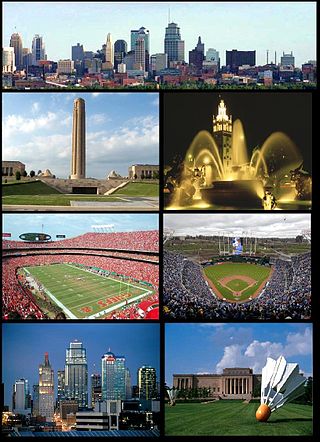
Kansas City, Missouri is the largest city in the U.S. state of Missouri by population and area. Most of the city lies within Jackson County, with portions spilling into Clay, Platte, and Cass counties. It is the central city of the Kansas City metropolitan area, which straddles the Missouri–Kansas state line and has a population of 2,392,035. As of the 2020 census, the city had a population of 508,090, making it the 37th most-populous city in the United States, as well as the sixth-most populous city in the Midwest. Kansas City was founded in the 1830s as a port on the Missouri River at its confluence with the Kansas River from the west. On June 1, 1850, the town of Kansas was incorporated; shortly after came the establishment of the Kansas Territory. Confusion between the two ensued, and the name Kansas City was assigned to distinguish them soon after.
The Kansas City metropolitan area is a bi-state metropolitan area anchored by Kansas City, Missouri. Its 14 counties straddle the border between the U.S. states of Missouri and Kansas. With 8,472 square miles (21,940 km2) and a population of more than 2.2 million people, it is the second-largest metropolitan area centered in Missouri and is the largest metropolitan area in Kansas, though Wichita is the largest metropolitan area centered in Kansas. Alongside Kansas City, Missouri, these are the suburbs with populations above 100,000: Overland Park, Kansas; Kansas City, Kansas; Olathe, Kansas; Independence, Missouri; and Lee's Summit, Missouri.
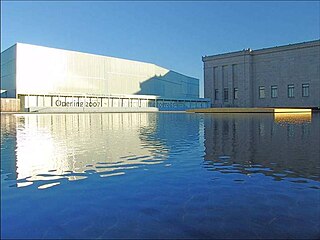
The Nelson-Atkins Museum of Art is an art museum in Kansas City, Missouri, known for its encyclopedic collection of art from nearly every continent and culture, and especially for its extensive collection of Asian art.
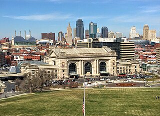
Downtown Kansas City is the central business district (CBD) of Kansas City, Missouri and the Kansas City metropolitan area which contains 3.8% of the area's employment. It is between the Missouri River in the north, to 31st Street in the south; and from the Kansas–Missouri state line eastward to Bruce R. Watkins Drive as defined by the Downtown Council of Kansas City; the 2010 Greater Downtown Area Plan formulated by the City of Kansas City defines the Greater Downtown Area to be the city limits of North Kansas City and Missouri to the north, the Kansas–Missouri state line to the west, 31st Street to the south and Woodland Avenue to the east. However, the definition used by the Downtown Council is the most commonly accepted.
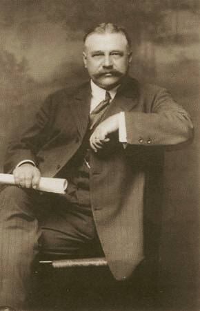
George Edward Kessler was an American pioneer city planner and landscape architect.

The history of the Kansas City metropolitan area has significant records since the 19th century, when Frenchmen from St. Louis, Missouri moved up the Missouri River to trap for furs and trade with the Native Americans. This strategic point for commerce and security at the confluence of the Kansas and Missouri Rivers became the Kansas City metropolitan area, straddling the border between Missouri and Kansas. Kansas City, Missouri was founded in 1838 and surpassed the competing Westport to become the predominant city west of St. Louis. The area had a major role in the westward expansion of the United States. The Santa Fe and Oregon trails ran through the area. In 1854, when Kansas was opened to Euro-American settlement, the Missouri-Kansas border became the first battlefield in the conflict in the American Civil War.

William Rockhill Nelson was an American real estate developer and co-founder of The Kansas City Star in Kansas City, Missouri. He donated his estate for the establishment of the Nelson-Atkins Museum of Art.
The list of neighborhoods of Kansas City, Missouri has nearly 240 neighborhoods. The list includes only Kansas City, Missouri and not the entire Kansas City metropolitan area, such as Kansas City, Kansas.

Ward Parkway is a boulevard in Kansas City, Missouri, United States. Ward Parkway begins at Brookside Boulevard on the eastern edge of the Country Club Plaza and travels west 2.8 miles along Brush Creek as U.S. Route 56 before turning south near Kansas-Missouri state line. It continues south for 4 miles, terminating at Wornall Road near Bannister Road. A short spur, Brush Creek Parkway, connects Ward Parkway to Shawnee Mission Parkway at State Line Road.
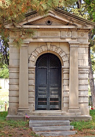
Elmwood Cemetery is a 43-acre (17 ha) historic rural cemetery, located in what became the urban area of 4900 Truman Road at the corner of Van Brunt Avenue in Kansas City, Missouri. With an estimated 35,000—38,000 plots, the cemetery is owned, operated, and maintained by the non-profit organization Elmwood Cemetery Society.

The Paseo is a major north–south parkway in Kansas City, Missouri. As the city's first major boulevard, it runs approximately 10 miles (16 km) through the center of the city: from Cliff Drive and Lexington Avenue on the bluffs above the Missouri River in the Pendleton Heights historic neighborhood, to 85th Street and Woodland Avenue. The parkway holds 223 acres (0.90 km2) of boulevard parkland dotted with several Beaux-Arts-style decorative structures and architectural details maintained by the city's Parks and Recreation department.
Main Street or Main is one of the major streets in Kansas City, Missouri and the Kansas City metropolitan area. Main Street serves as the main administrative dividing line for house numbering and east–west streets in Kansas City; for example, it separates East 59th Street from West 59th Street. Address numbers on east–west streets increase in both directions as one moves away from Main Street. This should not be confused with the Kansas City "East Side" and "West Side," a cultural distinction which has arisen from a history of racist segregation in the city, separated by Troost Avenue approximately 1 mile east of Main Street.

Hyde Park is a historic residential neighborhood and city park in Kansas City, Missouri.
39th Street is a major east–west street in Kansas City, Missouri, running almost 5 miles from State Line Road at the Kansas-Missouri border to Topping Avenue in Kansas City's East Side. It was originally named Rosedale Avenue as it led to the town of Rosedale. It continues west into Kansas as 39th Avenue through The University of Kansas Hospital's Kansas City, Kansas, campus.
Gillham Road is a major north/south main street that runs in Kansas City, Missouri from the intersection of 22nd Street at Oak Street to Harrison Road between 45th and 46th Streets. Gillham Road becomes Gillham Plaza from 31st Street to 34th Street. This causes Gillham Road to go over one block east into a residential neighborhood.

Troost Avenue is one of the major streets in Kansas City, Missouri and the Kansas City metropolitan area. Its northern terminus is at 4th Street and its southern terminus Bannister Road, totaling 10.7 miles (17.2 km). It is named after Kansas City's first resident physician, Benoist Troost.
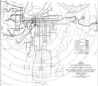
Streetcars in Kansas City were the primary public transit mode during the late 19th and early 20th centuries, like most North American cities. Kansas City, Missouri once had one of the most extensive streetcar systems in North America, but the last of its 25 streetcar routes was shut down in 1957. Kansas City joined all but five North American metropolises – Toronto, Boston, Philadelphia, San Francisco, and New Orleans – in replacing all their streetcar networks with buses. Three other cities, Newark, Pittsburgh, and Cleveland, operated rail lines more akin to modern light rail that remain operating.

The 1855 Harris-Kearney House is an historical site located in Kansas City, Missouri, in the Westport neighborhood. Originally, the house was located at the intersection of modern-day Westport Road and Main Street The home is the oldest brick residence in the city.

