Southwater

Last updated

Southwater
Church of the Holy Innocents, Southwater (NHLE Code 1259780).JPG
Church of the Holy Innocents, Southwater
West Sussex UK location map.svg
Red pog.svg
Southwater
Location within West Sussex
Area5.40 sq mi (14.0 km2)  [1]
Population10,025  [1] 2001 Census
10,730 (2011 Census) [2]
  Density 1,850/sq mi (716/km2)
OS grid reference TQ156262
  London 34 miles (55 km) NNE
Civil parish
  • Southwater
District
Shire county
Region
Country England
Sovereign state United Kingdom
Post town HORSHAM
Postcode district RH13
Dialling code 01403
Police Sussex
Fire West Sussex
Ambulance South East Coast
UK Parliament
Websitewww.southwater-village.co.uk/
List of places
UK
England
West Sussex
51°01′26″N0°21′09″W / 51.02379°N 0.35256°W / 51.02379; -0.35256

Southwater is a large village and civil parish in the Horsham District of West Sussex, England, with a population of roughly 10,000. It is administered within Horsham District Council and West Sussex County Council.

Contents

History

One of the oldest buildings in the parish is Great House Farmhouse, a listed building at Grade II* built in 1462 [3] from a late medieval structure in the Tudor period just west of the town. [4]

In the early 19th century Southwater was predominately a collection of large estates divided into leased farms. Whilst mixed agriculture provided a lucrative industry for centuries, much of the population of Southwater originated from the workforce of the brick industry and the arrival of the railway, which opened in 1866. [5] At the peak of production, the Southwater brickworks manufactured 18 million bricks a year, and employed 100 men. It was reported that Southwater bricks were used in the building of Christ’s Hospital, Victoria Station, RAAF Woomera Range Complex, [6] London sewers and many London air raid shelters in World War Two. [7] Following the closure of the brickworks, there was a project implemented to transform the area into a country park, which is now a major family attraction in the district. [8]

Community

In 2006 the centre of Southwater Village was renewed at a cost of £25 million. [9]

Southwater has three public houses: the Hen and Chicken; the Tipsy Fox; and the Lintot which opened soon after the building of Lintot Square the name is a reference to Barnaby Bernard Lintot (1675–1736), an English publisher born in Southwater. The first recorded alehouse in the village opened in 1542. [10]

Southwater Country Park

The Country Park is located on land originally named Andrews Farm which dates back to mediaeval times. The farm was sold in 1890 and became the Southwater brickyard owned by CJ Mills. The site was taken over by Sussex Bricks and Estates Co. in 1907 who changed their name to Redlands Bricks Ltd in 1958. [11] The railway yard in Southwater served the brickyard and was closed in 1966 as part of the Beeching cuts. The brickworks closed in 1981 after producing 1,000 million red engineering bricks from Southwater clay. The brickworks chimney was blown up by a lucky resident who won a fund raising draw. [12]

In the 1920s the bones of a dinosaur (Iguanodon) were found at the brickyard, fossilised in the clay. To commemorate this find, the statue of an Iguanodon was created and is displayed in Southwater's Lintot Square. The sculpture is named 'Iggy'. [13] To further celebrate Southwater's dinosaur history, a dinosaur themed children's park was created at the country park for families to enjoy. [14] Other historic items have been found at the park dating back to 500 BC. [15]

The country park was finally finished and ready for the public in 1985 and had nature trails, lots of paths, seating, a beach to paddle, a dipping pond and two beautiful lakes. Lennox Wood had been within the brickyard since the 1960s. A new lake named Cripplegate Lake was man made from the quarries that were used to subtract the clay needed to make the bricks. Cripplegate Lake is over 30 ft deep at its deepest point.

Southwater Country Park is a 70-acre site with three lakes and numerous access paths located close to the centre of the village. [16] The Park contains a visitor centre with information displays, and also a café, a skate park, and a children's adventure playground, and Southwater Water Sports Centre with facilities for sailing and canoeing. The Country Park and the Southwater Area Community Centre both have direct access to the Downs Link footpath/cycleway.

Over the years the lakes have become home to an abundance of fish and many water fowl. Lennoxwood is a fishing lake which has Pike, Perch, Tench, Roach, Chubb and Carp up to 25lb. Crucians and eels also live there. The park includes a beautiful wildlife area 'The Quarry', which is managed for nature conservation and supports wildlife such as lizards, Kingfisher, Nightingale, Heron, Buzzard, Red kite, Cormorant and various butterflies and dragonflies. [17] There used to be a small pond used for pond dipping by groups of local schoolchildren. Great Crested Newts were found which are an endangered species. The endangered Bee orchid has also been found at the park.

A pair of breeding Mute swans have lived on the park lakes for many years and they regularly travel between the lakes of the park. In 2021, the local authority erected a fence around the perimeter of the main lake which restricted the travel of the swans and led to an increased risk to the swans of dog attack when travelling between the lakes. This was especially dangerous for any cygnets travelling with the parent swans during spring and summer. A local resident, Amanda Botting, set up a petition to have the fence removed which gained 3,300 signatures. The petition was handed to the local authority, who recognised the concerns of the residents and installed a new Swan Gate in the fence to provide the swans easier access to and from the main lake in spring 2022. [18]

Church

Holy Innocents Anglican parish church dates from 1848–49 and is Grade II listed. [19] The Church was consecrated by Ashurst Turner Gilbert, Bishop of Chichester, on 7 June 1850, and the ecclesiastical parish was formed from part of Horsham Parish in the north and part of Shipley Parish in the south. [20]

Sport

Cricket

Southwater Cricket Club was founded in 1890, although the first recorded game played in the village was a Southwater XI playing a Shipley XI in 1858. [21] Between 1890 and 2018, Southwater CC played at a ground located next to the Village Hall, on land originally donated to the club by the Fletcher family. [22] In 2019, the club moved to a new ground and clubhouse on Church Lane, opposite the Holy Innocents Church, Southwater.

The senior 1st XI competes in Division 5 Central of the Sussex Cricket League, the 2nd XI in Division 10 West and 3rd XI in Division 12 West (North).

In 2019, the club won the Sussex Coaching Club of the Year Award. [23]

Football

Southwater has two amateur football teams, Southwater FC and Southwater Royals FC.

Southwater FC were founded in 1958, and currently play at the Southwater Sports Club. The club, nicknamed The Swifts, currently play in the Southern Combination Football League.

Southwater Royals FC were founded in 1997, originally known as Royal United. [24] The club are currently based at The Ghyll, Southwater.

Bowls

The Southwater Bowls Club were founded in 1990. [25] The clubhouse is located next to The Ghyll, Southwater.

Freedom of the Parish

The following people and military units have received the Freedom of the Parish of Southwater.

Individuals

[26]

Related Research Articles

<span class="mw-page-title-main">West Sussex</span> County of England

West Sussex is a ceremonial county in South East England. It is bordered by Surrey to the north, East Sussex to the east, the English Channel to the south, and Hampshire to the west. The largest settlement is Crawley, and the county town is the city of Chichester.

<span class="mw-page-title-main">Horsham District</span> Non-metropolitan district in England

Horsham is a local government district in West Sussex, England. It is named after the town of Horsham, which is its largest settlement and where the council is based. The district also includes the surrounding rural area and contains many villages, the largest of which are Southwater and Billingshurst. The district includes part of the South Downs National Park and part of the designated Area of Outstanding Natural Beauty of High Weald. At the 2021 census the district had a population of 147,487.

<span class="mw-page-title-main">Clapham, West Sussex</span> Human settlement in England

Clapham is a rural village and civil parish in the Arun District of West Sussex, England. It lies on varying downslopes and escarpment of the South Downs National Park three miles (5 km) north of Angmering on the A280 road and north of the A27 crossroads. It is adjacent to the village of Patching.

<span class="mw-page-title-main">Ifield, West Sussex</span> Human settlement in England

Ifield is a former village and now one of 14 neighbourhoods within the town of Crawley in West Sussex, England. Ifield is in the west of the town and is bordered by Ifield West, Horsham, Langley Green to the north east, West Green to the east across the ring road and Gossops Green and Bewbush to the south across the Arun Valley railway line.

<span class="mw-page-title-main">Henfield</span> Human settlement in England

Henfield is a large village and civil parish in the Horsham District of West Sussex, England. It lies 41 miles (66 km) south of London, 12 miles (19 km) northwest of Brighton, and 30 miles (48 km) east northeast of the county town of Chichester at the road junction of the A281 and A2037. The parish has a land area of 4,285 acres (1,734.1 ha). In the 2001 census 5,012 people lived in 2,153 households, of whom 2,361 were economically active. Other nearby towns include Burgess Hill to the east and Shoreham-by-Sea to the south. The population at the 2011 Census was 5,349.

<span class="mw-page-title-main">Pulborough</span> Human settlement in England

Pulborough is a large village and civil parish in the Horsham district of West Sussex, England, with some 5,000 inhabitants. It is located almost centrally within West Sussex and is 42 miles (68 km) south west of London. It is at the junction of the north–south A29 and the east–west A283 roads.

<span class="mw-page-title-main">Holy Innocents Church, Southwater</span> Anglican parish church in West Sussex, England

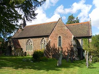
Holy Innocents Church is the Anglican parish church of Southwater, a village in the Horsham District of West Sussex, England. Built in 1849, the church has a cruciform footprint. Inside there are many stained glass windows, donated to the church by the Piper family and the Old Blues of Christ's Hospital School. The church grounds include the church, its graveyards, a house, a church room and a Scout and Guide hut.

<span class="mw-page-title-main">Ansty, West Sussex</span> Human settlement in England

Ansty is a village in the Mid Sussex district of West Sussex, England. It lies on the A272 road 1.4 miles (2.2 km) southwest of Cuckfield. It is in the civil parish of Ansty and Staplefield.

<span class="mw-page-title-main">Thakeham</span> Human settlement in England

Thakeham is a village and civil parish located north of the South Downs in the Horsham District of West Sussex, England. The village is situated approximately 12 miles south-west of Horsham and 11 miles north of the sea-side town of Worthing. Its nearest large village is Storrington. The parish includes the hamlets of Abingworth and Goose Green and has a land area of 1170.6 hectares.

<span class="mw-page-title-main">Nuthurst</span> Human settlement in England

Nuthurst is a village and civil parish in the Horsham district of West Sussex, England. The north of the parish borders Horsham town, with Nuthurst village 3 miles (5 km) south from the border. Within the parish is the estate and largely 19th-century country house of Sedgwick Park.

<span class="mw-page-title-main">Horsham</span> Market town in West Sussex, England

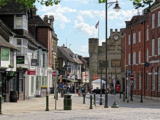
Horsham is a market town on the upper reaches of the River Arun on the fringe of the Weald in West Sussex, England. The town is 31 miles (50 km) south south-west of London, 18.5 miles (30 km) north-west of Brighton and 26 miles (42 km) north-east of the county town of Chichester. Nearby towns include Crawley to the north-east and Haywards Heath and Burgess Hill to the south-east. It is the administrative centre of the Horsham district.

<span class="mw-page-title-main">Capel, Surrey</span> Human settlement in England

Capel is a village and civil parish in southern Surrey, England. It is equidistant between Dorking and Horsham – about 5 miles (8.0 km) away. Around Capel, to the west, skirts the A24 road. Capel is approximately 2.5 miles (4.0 km) north of the West Sussex border, 26 miles (42 km) south of London and 12 miles (19 km) southeast of Guildford and is in the Mole Valley district. The village is in the north of a landscape called the Weald, meaning forest, which forms a significant minority of the land today, particularly towards the Greensand Ridge.

<span class="mw-page-title-main">Northchapel</span> Human settlement in England

Northchapel is a village and civil parish in Chichester District in West Sussex, England. It stands on the A283 road just south of the Surrey border, around 9 km north of Petworth.

Frederick Wheeler (1853–1931) (FRIBA) was a British architect, born in Brixton, Surrey, in October 1853. His parents were Christopher and Mary Ann Wheeler. He was articled to Charles Henry Driver (1832–1900), whose offices were at 7 Parliament Street, London SW1, and who is best known as the architect for the Victoria Embankment and Abbey Mills.

Rudgwick is a village and civil parish in the Horsham District of West Sussex, England. The village is 6 miles (10 km) west from Horsham on the north side of the A281 road. The parish's northern boundary forms part of the county boundary between Surrey and West Sussex.

<span class="mw-page-title-main">Southwater railway station</span> Former railway station in England

Southwater was a railway station on the Steyning Line which served the village of Southwater. A goods siding allowed for the transportation of coal and other raw materials to and from Southwater Brickworks.

<span class="mw-page-title-main">All Saints Church, Roffey</span> Church in West Sussex , United Kingdom

All Saints Church is the Anglican parish church of Roffey, in the Horsham district of the English county of West Sussex. The present church, built to serve the Victorian suburb of Roffey—part of the ancient market town of Horsham—replaced a schoolroom in which religious services had been held since 1856. Arthur Blomfield's Early English-style church, built of locally quarried sandstone and funded by a widow as a memorial to her late husband, was completed in 1878 and was allocated a parish immediately. Roman Catholic services were also held in the building to serve Roffey's Catholic population, but these ceased in the early 21st century. English Heritage has listed the church at Grade II for its architectural and historical importance.

<span class="mw-page-title-main">Horsham Unitarian Church</span> Church in West Sussex , United Kingdom

Horsham Unitarian Church is a Unitarian chapel in Horsham in the English county of West Sussex. It was founded in 1719 to serve the large Baptist population of the ancient market town of Horsham—home of radical preacher Matthew Caffyn—and the surrounding area. The chapel's congregation moved towards Unitarian beliefs in the 19th century, but the simple brick building continued to serve worshippers drawn from a wide area of Sussex. It is one of several places of worship which continue to represent Horsham's centuries-old tradition of Protestant Nonconformism, and is the town's second oldest surviving religious building—only St Mary's, the parish church, predates it. English Heritage has listed the chapel at Grade II for its architectural and historical importance.

Ian Thwaites was an English physician and cricketer. He played twenty-two first-class matches for Cambridge University Cricket Club between 1963 and 1964.

References

  1. 1 2 "2001 Census: West Sussex – Population by Parish" (PDF). West Sussex County Council. Archived from the original (PDF) on 8 June 2011. Retrieved 12 April 2009.
  2. "Civil Parish population 2011". Neighbourhood Statistics. Office for National Statistics. Retrieved 3 October 2016.
  3. Laker, Patsy; Andrews, Catherine (2008). Southwater A to Z: A Miscellany (Reprint 2019 ed.). Southwater Local History Group. pp. See entry for Charman Family of Great House Farm.
  4. Historic England. "Details from listed building database (1286023)". National Heritage List for England . Retrieved 12 August 2012.
  5. "Southwater Businesses Throughout the Years". www.madesimplemedia.co.uk. Retrieved 14 July 2022.
  6. Laker, Patsy; Andrews, Catherine (2008). Southwater A to Z: A Miscellany (Reprint 2019 ed.). Southwater: Southwater Local History Group. pp. See entry for Bricks and Brickyards.
  7. "Thames beachcomber" . Retrieved 15 August 2022.
  8. "Southwater Country Park". www.horsham.gov.uk. Retrieved 16 November 2016.
  9. "Southwater cycle network review" (PDF). Transport Initiatives. Horsham District Council. p. 4.
  10. Hudson, T.P. (1986). A History of the County of Sussex: Volume VI Part II: Bramber Rape (North-Western Part) including Horsham (Victoria County History) (Hardback ed.). Oxford University Press. pp. Volume V1 Part 2. ISBN   9780197227671.
  11. "Southwater Businesses Through The Years" . Retrieved 9 August 2022.
  12. "A short history of Southwater and its church" . Retrieved 9 August 2022.
  13. "Geocaching Southwater Iguanodon" . Retrieved 15 August 2022.
  14. "Southwater Country Park - Dinosaur Island" . Retrieved 15 August 2022.
  15. "Southwater Parish Council History" . Retrieved 15 August 2022.
  16. "Horsham district council Southwater Country Park". Southwater Country Park. Retrieved 3 April 2011.
  17. "Southwater Parish Council - Southwater Country Park" . Retrieved 15 August 2022.
  18. "New swan walk solution found at Southwater Country Park" . Retrieved 14 August 2022.
  19. Historic England. "Details from listed building database (1259780)". National Heritage List for England . Retrieved 12 August 2012. Grade II Listing details of Holy Innocents Church.
  20. "Southwater – Holy Innocents – Sussex Parish Churches" . Retrieved 11 December 2022.
  21. "The History of Cricket in Southwater". At Home Estates. Retrieved 10 June 2022.
  22. Laker, Patsy; Andrews, Catherine (2008). Southwater A to Z: A Miscellany (2019 Reprint ed.). Southwater: Southwater Local History Group. pp. See entry for Cricket Club.
  23. "Southwater CC". southwater.play-cricket.com. Retrieved 10 June 2022.
  24. "Our Story 1997 - 2020 | Southwater Royals Football Club". Southwater Royals FC. Retrieved 10 June 2022.
  25. "Southwater Bowls Club". www.southwaterbowlsclub.co.uk. Retrieved 10 June 2022.
  26. Toth, Veronika (22 March 2024). "Southwater Parish Council honours local champions with Freedom of the Parish Award". Sussex World. Retrieved 12 April 2024.