The Coral Sea Islands Territory is an external territory of Australia which comprises a group of small and mostly uninhabited tropical islands and reefs in the Coral Sea, northeast of Queensland, Australia. The only inhabited island is Willis Island. The territory covers 780,000 km2 (301,160 sq mi), most of which is ocean, extending east and south from the outer edge of the Great Barrier Reef and includes Heralds Beacon Island, Osprey Reef, the Willis Group and fifteen other reef/island groups. Cato Island is the highest point in the Territory.

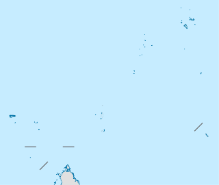
The Chagos Archipelago or Chagos Islands is a group of seven atolls comprising more than 60 islands in the Indian Ocean about 500 kilometres (310 mi) south of the Maldives archipelago. This chain of islands is the southernmost archipelago of the Chagos-Laccadive Ridge, a long submarine mountain range in the Indian Ocean. In the north are Peros Banhos, Salomon Islands and Nelsons Island; in the south-west are Three Brothers, Eagle, Egmont and Danger Islands. Diego Garcia is the largest and lies in the southeast part of the Archipelago.

Peros Banhos, Pedro dos Banhos or Baixos de Pêro dos Banhos in old maps, is a formerly inhabited atoll in the Chagos Archipelago of the British Indian Ocean Territory. Île Yeye, located at the northeastern corner of the atoll, is the island of the Chagos Archipelago that is closest to the Maldives.
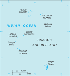
The British Indian Ocean Territory (BIOT) is an archipelago of 55 islands in the Indian Ocean, located south of India. It is situated approximately halfway between Africa and Indonesia. The islands form a semicircular group with an open sea towards the east. The largest, Diego Garcia, is located at the southern extreme end. It measures 60 square kilometres (23 sq mi) and accounts for almost three-quarters of the total land area of the territory. Diego Garcia is the only inhabited island and is home to the joint UK-US naval support facility. Other islands within the archipelago include Danger Island, Three Brothers Islands, Nelson Island, and Peros Banhos, as well as the island groups of the Egmont Islands, Eagle Islands, and the Salomon Islands.

The Salomon Islands or Salomon Atoll is a small atoll of the Chagos Archipelago, British Indian Ocean Territory.

Eagle Islands is a group of two islands in the Chagos Archipelago. They are located on the central-western rim of the Great Chagos Bank, which is the world's largest coral atoll structure.

Danger Island is the westernmost and the southernmost island of the Great Chagos Bank, which is the world's largest coral atoll structure, located in the Chagos Archipelago in the Indian Ocean.

Egmont Islands is an uninhabited atoll administered by the United Kingdom. They are one of the few emerged coral atolls that make up the Chagos Archipelago, British Indian Ocean Territory.
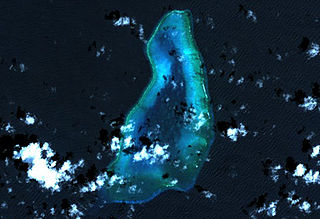
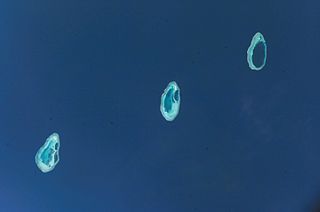
Blenheim Reef is a partly submerged atoll structure in the Chagos Archipelago, Indian Ocean. It includes the coral reef of Baxio Predassa in its southeastern rim, plus another completely submerged part. It is located in the northeastern part of the Chagos Archipelago. It measures almost eleven kilometres (north–south) by more than four kilometres (east–west), with a total area of 36.8 square kilometres, including the lagoon of 8.5 km², the difference being accounted for the mostly by the reef flat. Only on the eastern side, there are a few sand cays above the water. The largest of them is East Island, which is not quite 200 metres long and 70 metres wide. The other islands in the group are North, Middle and South. Only a few grasses grow on the island. The lagoon is up to 18 metres deep and encumbered with rock. The fringing coral reef has a wide passage in the southwest. The closest land is Takamaka Island in the Salomon Islands Atoll, about 20 kilometres to the southwest.
The Great Chagos Bank, in the Chagos Archipelago, about 500 km (310 mi) south of Maldives, is the largest atoll structure in the world, with a total area of 12,642 km2 (4,881 sq mi). The atoll is administered by the United Kingdom through the British Indian Ocean Territory (BIOT).
Colvocoresses Reef is a wholly submerged atoll in the Indian Ocean. It is located in the northeastern part of the Chagos Archipelago, near Speakers Bank and Blenheim Reef. The reef is 8 km long, and measures 1 to 2 km across. Breakers are visible only during heavy seas.
Pitt Bank is a wholly submerged atoll structure in the Southwest of the Chagos Archipelago. It is almost 56 km long Northwest to Southeast, with a width between 20 and 30 km. It stretches from 06°48'S to 07°16'S and 071°06'E to 071°36'E. The total size is 1317 km, making it the second largest ocean bank in the Chagos Archipelago, after the Great Chagos Bank, and before Speakers Bank. The closest land is Île Lubine of Egmont Atoll, located 22 km northeast off the northern end of Pitt Bank. The least depth is 7 metres at the Southeastern Rim, and the deepest areas of the former lagoon reach 44 metres.
Lakshadweep is a union territory of India. It is an archipelago of 36 islands in the Arabian sea, located 200 to 440 km off of the mainland's southwestern coast.
Desroches Island or Île Desroches is the main island of the Amirante Islands, part of the Outer Islands of the Seychelles.
Pedro Bank is a large bank of sand and coral, partially covered with seagrass, about 80 km south and southwest of Jamaica, rising steeply from a seabed of 800 metres depth. It slopes gently from Pedro Cays to the west and north with depths from 13 to 30 metres. The total area of the bank within the 100-metre (328-foot) isobath measures 8,040 square kilometres. The area of a depth to 40 metres is triangular, 70 kilometres long east-west, and 43 kilometres wide. 2,400 square kilometres are less than 20 metres deep. With its islets, cays and rocks, a total land area of 270,000 m2 (2,906,256 sq ft), it is the location of one of the two offshore island groups of Jamaica, the other one being the Morant Cays. The bank is centered at 17°06′N78°20′W.
The Rowley Shoals is a group of three atoll-like coral reefs south of the Timor Sea, about 260 km (160 mi) west of Broome on the northwestern Australian coast, centered on 17°20′S119°20′E, on the edge of one of the widest continental shelves in the world. Each atoll covers an area of around 80 to 90 km2 within the rim of the reef, including the lagoons, while the land areas are negligible. They belong to Western Australia. They all rise steeply from the surrounding ocean floor. To the northeast lie the Scott and Seringapatam Reefs which are located on the same undersea platform.

D'Arros Island is part of the Amirante Islands group, which are in the Outer Islands coral archipelago of the Seychelles islands and nation. The island is located west of the granitic Inner Seychelles archipelago, with a distance of 255 km south of Victoria, Seychelles.

Chesterfield Islands are a French archipelago of New Caledonia located in the Coral Sea, 550 km (300 nmi) northwest of Grande Terre, the main island of New Caledonia. The archipelago is 120 km long and 70 km broad, made up of 11 uninhabited islets and many reefs. The land area of the islands is less than 10 km².
The Chagos Marine Protected Area, located in the central Indian Ocean in the British Indian Ocean Territory of the United Kingdom, is one of the world's largest marine protected areas, and one of the largest protected areas of any type on Earth. It was established by the British government on 1 April 2010 as a massive, contiguous, no-take marine reserve, it encompasses 640,000 square kilometres (250,000 sq mi) of ocean waters, including roughly 70 small islands and seven atolls of the Chagos Archipelago.

The Maldives–Lakshadweep–Chagos Archipelago tropical moist forests is a tropical moist broadleaf forest ecoregion in South Asia. It spans a chain of coralline islands in the Indian Ocean, including Lakshadweep, a union territory of India; the Maldives, an independent country; and the British Indian Ocean Territory, an overseas territory of the United Kingdom.
