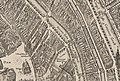
Nieuwezijds Achterburgwal
The Nieuwezijds Achterburgwal (New Side Behind Bastion Wall [lower-alpha 1] ) is a former canal in Amsterdam, the Netherlands. From around 1380 to 1450 it was part of the town's defenses, forming the western limit of the medieval city of Amsterdam.
Until about the 14th century, the river Amstel divided the city in two roughly equal parts--the Oudezijde with the Oude Kerk and the Nieuwezijde with the Nieuwe Kerk. In 1342 a simple earthen embankment was raised to protect the small town of Amsterdam, with a narrow canal in front of it where the Oudezijds Voorburgwal and Nieuwezijds Voorburgwal are today.
As the town grew, new defenses were built further out: the Oudezijds Achterburgwal in 1367 and the Nieuwezijds Achterburgwal in 1380.
At this time the town's population was between 3,000 and 5,000, so construction of the fortifications would have been a huge effort. To protect the city, a canal was dug on each side, with a city wall behind it made of dirt with a wooden palisade. When new fortifications were built around 1385, the existing ones became "Voorburgwal" ("voor" meaning "in front"), and the new ones "Achterburgwal" ("achter" meaning "behind"), on both the old side and the new side. This created the Oudezijds Voorburgwal, Oudezijds Achterburgwal, Nieuwezijds Voorburgwal, and Nieuwezijds Achterburgwal, dug in 1380.
Amsterdam continued to grow, and in 1425 a broad new canal was dug further east of the town, where the Geldersekade and Kloveniersburgwal are today. Twenty-five years later the Singel was completed round the west side of the city from the IJ to the Amstel.
The Nieuwezijds Voorburgwal no longer had a defensive purpose.
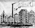
The brewery "De Hooiberg" was established on the Nieuwezijds Voorburgwal in 1592 on the site now occupied by the Hotel Die Port van Cleve. It was very successful, and in the years that followed, the building was expanded between the Nieuwezijds Voorburgwal and Nieuwezijds Voorburgwal. In 1863 the building complex was bought by Gerard Adriaan Heineken. [3] After the canal was filled in, Heineken moved his brewery to the Stadhouderskade in Amsterdam.
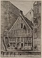
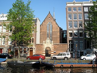
The Nieuwezijds Achterburgwal had warehouses and stables that belonged to the larger houses on the Nieuwezijds Voorburgwal. [4]
In May 1621 the printer and newspaper publisher Broer Jansz (1579–1652) settled on the Nieuwezijds Achterburgwal in a house named the "Silvere Can". He remained here for the rest of his career.
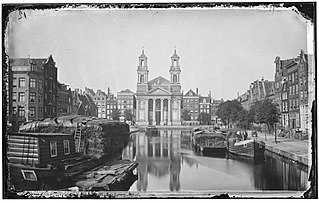
The Donkere Sluis was built between 1625 and 1657 connecting the Singel to the Nieuwezijds Voorburgwal via the Nieuwezijds Achterburgwal. It provided a water route between the old city and the expansion beyond the Singel. Without it, water traffic had to use the Kattengat or the Boerenverdriet.
With the third expansion, the grachtengordel (canal belt) had cross-canals at regular intervals, solving the problem. Since land was in short supply, in the 1661 the City horse stables were built over the Donkere Sluis.
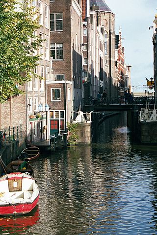
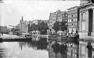
By the mid 1800s, the canal mainly held warehouses and stables near the houses on Nieuwezijds Voorburgwal. The canal was a long, smelly ditch with uneven and narrow quays.
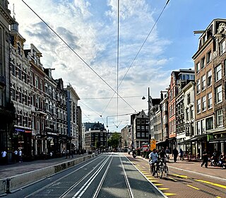
The city council decided to fill in the Nieuwezijds Achterburgwal on 28 January 1866. The canal was filled in 1868 at the same time as the Kattegat, a ditch between Nieuwezijds Achterburgwal and the Stroomarkt. The purpose was to improve public health and to make the city more accessible. The change seems to have been popular with the residents. The name was changed to Spuistraat in November 1867 and a double row of chestnut trees was planted along it. On the south side, the street ends at the Spui. [10]


.jpg)