
St. Croix County is a county in the U.S. state of Wisconsin. As of the 2010 census, the population was 84,345. Its county seat is Hudson. The county was created in 1840 and organized in 1849.

Pierce County is a county located in the U.S. state of Wisconsin. As of the 2010 census, the population was 41,019. Its county seat is Ellsworth.

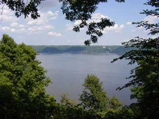
River Falls is a city in Pierce and St. Croix counties in the U.S. state of Wisconsin. It is adjacent to the Town of River Falls in Pierce County and the Town of Kinnickinnic in St. Croix County. River Falls is the most populous city in Pierce county. The population was 15,000 at the 2010 census, with 11,851 residing in Pierce County, and 3,149 in St. Croix County. It is part of the Minneapolis-St. Paul metropolitan area and is about 30 miles (48 km) east of the center of that region.

Afton State Park is a state park of Minnesota, USA, on the St. Croix River in Washington County. Its hiking trails offer views of the river, rolling glacial moraine, and bluffland it preserves. It is a popular place for birdwatching, picnics, camping, and other typical outdoor recreational activities. To deter overuse of a state park only 20 miles (32 km) from downtown St. Paul, there is no vehicle access to the camping area or swimming beach.

Wild River State Park is a state park of Minnesota, United States, curving along 18 miles (29 km) of the St. Croix River. This long, narrow park is shaped somewhat like a sideways 'S', with development largely concentrated in the lower third. The remote upper sections flank the mouth of a tributary called the Sunrise River. The park is managed to provide quieter, more nature-oriented recreation as a counterpoint to the busier William O'Brien and Interstate State Parks downstream.

Interstate Park comprises two adjacent state parks on the Minnesota–Wisconsin border, both named Interstate State Park. They straddle the Dalles of the St. Croix River, a deep basalt gorge with glacial potholes and other rock formations. The Wisconsin park is 1,330 acres (538 ha) and the Minnesota park is 298 acres (121 ha). The towns of Taylors Falls, Minnesota and St. Croix Falls, Wisconsin are adjacent to the park. Interstate Park is within the Saint Croix National Scenic Riverway and the Ice Age National Scientific Reserve. The western terminus of the Ice Age National Scenic Trail is on the Wisconsin side. On the Minnesota side, two areas contain National Park Service rustic style buildings and structures that are listed on the National Register of Historic Places.

William O'Brien State Park is a 1,520-acre (6.2 km2) state park of Minnesota, USA, along the St. Croix River. Its hiking trails traverse rolling glacial moraine, riparian zones, restored oak savanna, wooded areas and bogs. It is a popular place for birdwatching, picnics, camping, cross-country skiing, canoeing, fishing, and other typical outdoor recreational activities.
Frontenac State Park is a state park of Minnesota, United States, on the Mississippi River 10 miles (16 km) southeast of Red Wing. The park is notable both for its history and for its birdwatching opportunities. The centerpiece of the park is a 430-foot-high (130 m), 3-mile-long (4.8 km) steep limestone bluff overlooking Lake Pepin, a natural widening of the Mississippi. The bluff is variously called Garrard's Bluff or Point No-Point, the latter name coming from riverboat captains because of the optical illusion that it protruded into the Mississippi River. There is a natural limestone arch on the blufftop called In-Yan-Teopa, a Dakota name meaning "Rock With Opening". Park lands entirely surround the town of Frontenac, once a high-class resort at the end of the 19th century.

The Mississippi National River and Recreation Area protects a 72-mile (116 km) and 54,000-acre (22,000 ha) corridor along the Mississippi River from the cities of Dayton and Ramsey, Minnesota to just downstream of Hastings, Minnesota. This includes the stretch of Mississippi River which flows through Minneapolis and St. Paul, Minnesota. This stretch of the upper Mississippi River includes natural, historical, recreational, cultural, scenic, scientific, and economic resources of national significance. This is the only national park dedicated exclusively to the Mississippi River. It is located in parts of Anoka, Dakota, Hennepin, Ramsey, and Washington counties, all within the Minneapolis–Saint Paul metropolitan area.

St. Croix State Park is a state park in Pine County, Minnesota, USA. The park follows the shore of the St. Croix River for 21 miles (34 km) and contains the last 7 miles (11 km) of the Kettle River. At 33,895 acres (13,717 ha) it is the largest Minnesota state park. It was developed as a Recreational Demonstration Area in the 1930s, and is one of the finest surviving properties of this type in the nation. 164 structures built by the Civilian Conservation Corps and the Works Progress Administration survive, the largest collection of New Deal projects in Minnesota. As a historic district they were listed on the National Register of Historic Places and proclaimed a National Historic Landmark in 1997.

Three Rivers Park District is a special park district serving the suburban areas of the Twin Cities including suburban Hennepin, Carver, Dakota, Scott and Ramsey counties. Three Rivers's mission is "To promote environmental stewardship through recreation and education in a natural resources-based park system." Three Rivers operates twenty parks and ten regional trails, with at least two more regional trails planned. Nearly seven million people visit Three Rivers facilities each year.
The Kettle Moraine State Forest is a state forest in southeastern Wisconsin. The chief feature of the reserve is the Kettle Moraine, a highly glaciated area. The area contains very hilly terrain and glacial landforms, such as kettles, kames and eskers. The 56,000-acre (23,000 ha) forest is divided into two large and three small units, which are spread across a hundred miles.
The Willard Munger State Trail is a system of recreational trails between Hinckley, Minnesota and Duluth, Minnesota. There are three segments to the trail, Hinckley to Duluth Segment, Alex Laveau Memorial Trail, and Matthew Lourey State Trail.

The Saint Croix National Scenic Riverway is a federally protected system of riverways located in eastern Minnesota and northwestern Wisconsin. It protects 252 miles (406 km) of river, including the St. Croix River, and the Namekagon River, as well as adjacent land along the rivers. The St. Croix National Scenic Riverway is one of the original eight National Wild and Scenic Rivers, largely as a result of legislation by senators Walter Mondale of Minnesota and Gaylord Nelson of Wisconsin. The largest scenic riverway east of the Mississippi River, it lies within parts of eight counties in Wisconsin: Bayfield, Burnett, Douglas, Pierce, Polk, St. Croix, Sawyer, and Washburn; and three in Minnesota: Chisago, Pine, and Washington.
Wild Mountain is a ski and snowboard area in Amador Township, Chisago County, near Taylors Falls, Minnesota. It features 26 runs, including 4 terrain parks, which include jumps, rails, boxes, quarter-pipes and half-pipes, which are both man made and natural. During the summer months of June, July and August, a water park, an alpine slide, and a go-kart track become operational. The site is also the first ski and snowboard resort in the Midwest to open every year, which is usually broadcast on the local news networks.
Afton Alps is a ski area, which hosts a collection of ski and snowboard trails, located along the St. Croix River in the northeast corner of Denmark Township, Washington County, south of Afton, Minnesota in the United States. There are nearly 300 acres (1.2 km2) skiable at Afton Alps. The ski hill has 300 feet (91 m) of vertical drop. The Alps often utilize artificial snow for maintaining the slopes. There are a total of 50 trails with 18 chairlifts, two conveyor lifts, and two rope tows in the Landing Zone Terrain Park. There are six chalets, including the Meadows Chalet, the Highlands Chalet, the Alpine Chalet, Landing Zone and the Alps Chalet. During the summer, Afton Alps operates an eighteen-hole golf course and wedding receptions / hall rental.

The Chengwatana State Forest is a state forest located in Pine and Chisago counties in Minnesota. Its name is derived from the Ojibwe: Zhingwaadena, meaning white-pine town, after the nearby ghost town and township. Eastern White Pine was historically the dominant tree species in the surrounding forest prior to intensive logging at the end of the nineteenth century.


