Wembley is a large suburb in north-west London, England, 8 miles (13 km) northwest of Charing Cross. It includes the neighbourhoods of Alperton, North Wembley, Preston, Sudbury, Tokyngton and Wembley Park. The population was 102,856 in 2011.

Walsall is a market town and administrative centre in the West Midlands County, England. Historically part of Staffordshire, it is located 9 miles (14 km) north-west of Birmingham, 7 miles (11 km) east of Wolverhampton and 9 miles (14 km) from Lichfield.

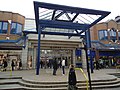
Harrow is a large town in Greater London, England, and serves as the principal settlement of the London Borough of Harrow. Lying about 9.5 miles (15.3 km) north-west of Charing Cross and 5.4 miles (8.7 km) south of Watford, the entire town including its localities had a population of 149,246 at the 2011 census, whereas the wider borough had a population of 250,149.

The St. Enoch Centre is a shopping mall located in the city centre of Glasgow, Scotland. The centre is located adjacent to St Enoch Square. The Architects were the GMW Architects. The construction, undertaken by Sir Robert McAlpine, began in 1986, and the building was opened to the public on 25 May 1989. It was officially opened by the then-Prime Minister Margaret Thatcher, in February of the following year.

Metrocentre is a shopping centre and entertainment complex in the Dunston area of Gateshead. It is located on the former site of Dunston Power Station, near to the River Tyne.

British Home Stores, commonly abbreviated to BHS and latterly legally styled BHS Ltd, was a British department store chain, primarily selling clothing and household items. In its later years, the company began to expand into furniture, electronics, entertainment, convenience groceries and fragrance and beauty products.

Allders was an independent department store operating in the United Kingdom.
Primark Stores Limited is an Irish multinational fast fashion retailer with headquarters in Dublin, Ireland. It is a subsidiary of Associated British Foods and has stores across Europe and in the United States. The Penneys brand is not used outside of Ireland because it is owned elsewhere by American retailer J. C. Penney.

Middleton Grange is a shopping centre in Hartlepool, England. It was built in 1969 and it was opened by Princess Anne on 27 May 1970. The site of the shopping centre was originally terraced streets that were demolished in the late 1960s.

The Haymarket Shopping Centre is a shopping centre in the city centre of Leicester, England. It was opened on 4 June 1973 as the Haymarket Centre and was the country's second shopping centre after the Bull Ring, Birmingham. It is located east of and adjacent to the Clock Tower.

Northumberland Street is a major shopping street in the city of Newcastle upon Tyne, in the North East of England. It is home to a wide range of different retailers, banks and cafes, and in terms of rental per square foot, Northumberland Street is the most expensive location in the UK outside London to own a shop. There are currently over 51 retailers including pubs on Newcastle's Northumberland Street.

Hempstead is a village near Gillingham, Kent in South East England. Historically a small hamlet, Hempstead grew throughout the 20th century to become part of the urban area of the Medway Towns. Hempstead is located on the southern edge of the Unitary authority of Medway, surrounded by Wigmore and the A278 trunk road to the east, Capstone valley to the west and the M2 motorway and the village of Bredhurst to the south. Most of Hempstead is in a valley, with Hempstead Valley Drive running along its length with housing on both sides.

St David's, previously known as St David's Shopping Centre, is one of the principal shopping centres in the city centre of Cardiff, Wales. It is in The Hayes area of the southern city centre. Following the extension of St David's 2 in 2009, St David's is the third busiest shopping centre in the United Kingdom.
Freshney Place is a shopping centre in Grimsby, North East Lincolnshire. Located in the centre of Grimsby it is visited annually by 400000 shoppers and employs over 2000 retail workers. The centre houses over 100 stores, with the anchor stores of Marks and Spencer, Next, Primark, Deichmann, British Heart Foundation and Game from 2018.

The Moor Quarter is one of Sheffield's twelve designated quarters, built around and named for The Moor, a pedestrianised thoroughfare. It is bound by Furnival Gate in the north-east, Eyre Street in the south-east, St Mary's Gate to the south, and Moore Street and Charter Row to the north-west.

Eastgate Shopping Centre is located in Inverness, serving the largest shopping catchment area in the United Kingdom.

Eden, known more popularly as the Eden Centre, is a shopping and entertainment complex in High Wycombe, Buckinghamshire in the south east of England. With a floor area of 850,000 square feet (79,000 m2), it is the 37th largest shopping centre in the United Kingdom and the largest in the surrounding area.

Coopers Square is an indoor shopping centre located in Burton-upon-Trent, Staffordshire, England. It is owned by the Grosvenor Group. The total retail area for the shopping centre is 35,766 m2 (384,980 sq ft). The shopping centre has 800 car parking spaces, with a ground car park as well as a rooftop car park.

Livat Hammersmith is a retail, residential and office complex located off King Street in Hammersmith in the London Borough of Hammersmith and Fulham. Along with the other Livat Centres, it is operated by the Ingka Centres division of INGKA Holding. It was formerly known as the Kings Mall.

St George's is a covered shopping centre in Harrow, Greater London, which opened in 1996. It is located at St Anns Road in the town centre nearby but separate from the St Anns centre. As of 2015 the centre has 30 units for retail, leisure and restaurant uses across three floors, including TK Maxx, Boots, Nando's, Vue and Fitness First. St George's has an annual footfall of 8.9 million. It is anchored by TK Maxx and the 9-screen Vue cinema.