
KwaZulu-Natal is a province of South Africa that was created in 1994 when the Zulu bantustan of KwaZulu and Natal Province were merged. It is located in the southeast of the country, with a long shoreline on the Indian Ocean and sharing borders with three other provinces and the countries of Mozambique, Eswatini and Lesotho. Its capital is Pietermaritzburg, and its largest city is Durban. It is the second-most populous province in South Africa, with slightly fewer residents than Gauteng.

The Tugela River is the largest river in KwaZulu-Natal Province, South Africa. With a total length of 531 km (330 mi), it is one of the most important rivers of the country.

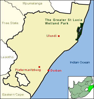
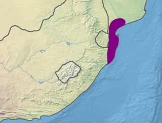
iSimangaliso Wetland Park is situated on the east coast of KwaZulu-Natal, South Africa, about 235 kilometres north of Durban by road. It is South Africa's third-largest protected area, spanning 280 km of coastline, from the Mozambican border in the north to Mapelane south of the Lake St. Lucia estuary, and made up of around 3,280 km2 of natural ecosystems, managed by the iSimangaliso Authority. The park includes:
The Lubombo Transfrontier Conservation Area was born out of the Peace Park Foundation’s vision to establish a network of transfrontier conservation areas in southern Africa. It straddles the border between South Africa’s KwaZulu-Natal province, southern Mozambique, and Eswatini.

uMkhuze Game Reserve is a 40,000-hectare game reserve in northern Zululand, KwaZulu-Natal, South Africa. It was proclaimed a protected area on 15 February 1912.
Ezemvelo KZN Wildlife is a governmental organisation responsible for maintaining wildlife conservation areas and biodiversity in KwaZulu-Natal Province, South Africa. Their headquarters is in Queen Elizabeth Park situated on the northern slopes of Pietermaritzburg, the KwaZulu-Natal provincial capital. Prior to 1994, it was known as the Natal Parks Board.
Mtubatuba is a town north of Richards Bay close to the entrance of Ncivi and the iSimangaliso Wetland Park but now the isimangaliso wetland park is known to be under Mtuba town in KwaZulu-Natal, South Africa.
Mont-aux-Sources is a mountain in Southern Africa, forming one of the highest portions of the Drakensberg Range. It is mostly within Lesotho, with parts in the KwaZulu-Natal and Free State provinces of South Africa.

The Umfolozi River is a river in KwaZulu-Natal, a province of South Africa. It is formed by the confluence of the Black and White Umfolozi Rivers near the southeastern boundary of the Hluhluwe-Umfolozi Game Reserve. The isiZulu name imFolozi is generally considered to describe the zigzag course followed by both tributaries, though other explanations have been given.
Kosi Bay is a series of four interlinked lakes in the Maputaland area of KwaZulu-Natal, South Africa.

The Kwazulu-Cape coastal forest mosaic is a subtropical moist broadleaf forest ecoregion of South Africa. It covers an area of 17,800 square kilometers (6,900 sq mi) in South Africa's Eastern Cape and KwaZulu-Natal provinces.
The Maputaland coastal forest mosaic is a subtropical moist broadleaf forest ecoregion on the Indian Ocean coast of Southern Africa. It covers an area of 29,961 square kilometres (11,568 sq mi) in southern Mozambique, Eswatini, and the KwaZulu-Natal Province of South Africa. Mozambique's capital Maputo lies within the ecoregion.

Tony Charles (Mashesha) Pooley (1938–2004) was a South African naturalist, award-winning conservationist and one of the world's foremost authorities on the Nile crocodile.

Sodwana Bay is a bay in South Africa on the KwaZulu Natal north coast, between St. Lucia and Lake Sibhayi. It is in the Sodwana Bay National Park, and the Maputaland Marine Reserve, and is a popular recreational diving destination. The term is commonly used to refer to both the marine reserve and the terrestrial park, as well as the geographical bay.

The Zulu Kingdom, sometimes referred to as the Zulu Empire or the Kingdom of Zululand, was a monarchy in Southern Africa that extended along the coast of the Indian Ocean from the Tugela River in the south to Pongola River in the north.
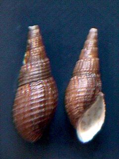
Tarebia granifera, common name the quilted melania, is a species of freshwater snail with an operculum, an aquatic gastropod mollusk in the family Thiaridae.
False Bay Park, a Ramsar site wetland since 2015, is a nature reserve that protects the western shores of the freshwater bay, False Bay, and is situated near the coast of northern KwaZulu-Natal, South Africa. False Bay is connected to Lake St. Lucia and both are included in the iSimangaliso Wetland Park.. It covers 1,500 hectares and is located at 34° 4′ S, 18° 30′ E.
St Lucia Game Reserve, is part of the St Lucia Estuary and with that the focal point of the iSimangaliso Wetland Park, in the KwaZulu-Natal, province of South Africa. The Game Reserve was established in 1895.
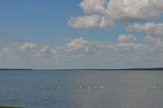
Lake St Lucia is an estuarine lake system in northern KwaZulu-Natal, South Africa. It is the largest estuarine lake in Southern Africa, covering an area of approximately 350 square kilometres (140 sq mi), and falls within the iSimangaliso Wetland Park.


