St Mary's Bay, Kent

Last updated

St Mary's Bay
St Marys Bay, Kent - Dunstall Lane Entrance.jpg
The entrance to Dunstall Lane
Kent UK location map.svg
Red pog.svg
St Mary's Bay
Location within Kent
Population2,819 (parish, 2011 Census) [1]
OS grid reference TR089276
Civil parish
  • St Mary in the Marsh
District
Shire county
Region
Country England
Sovereign state United Kingdom
Post town Romney Marsh
Postcode district TN29 0
Dialling code 01797/01303
Police Kent
Fire Kent
Ambulance South East Coast
UK Parliament
Website Official website
List of places
UK
England
Kent
51°00′38″N0°58′38″E / 51.0105°N 0.9771°E / 51.0105; 0.9771

St Mary's Bay, also known as The Bay, is a coastal village in Kent, England. Situated on Romney Marsh, St Mary's Bay has a long sandy beach which stretches north to Dymchurch and south to Littlestone-on-Sea. It has a station on the Romney, Hythe and Dymchurch Railway.

Contents

History

During the 1950s and 1960s, St Mary's Bay was a popular destination for vacationers. 'The Bay' had a number of holiday camps, among them Maddieson's Golden Sands at Dunstall Lane, the School Journey Centre at Jefferstone Lane, and the Rugby Club camp on the opposite (sea) side of the A259 main road between Jefferstone Lane and Taylor's Lane. The School Journey Center closed at the end of the 1970s, and the site is now occupied by a housing estate. Also at St Mary's Bay was the Sands Holiday Motel and accompanying Bahia Bar, sited on the seafront roughly opposite the turning to Jefferstone Lane on the A259. The hotel and bar were demolished after being badly damaged in the Great Storm of 1987.

St Mary's Bay was the site of a home for mentally handicapped children. Known as Pirates Spring and located on Coast Drive close to the beach, the home was run by the National Society for Mentally Handicapped Children (now Mencap) and had the actor Brian Rix among its patrons. After the facility closed in the 1980s the building housed a hotel and country club in the 1990s. The Springs Community now provides sheltered housing accommodation for people with the special needs associated with autism spectrum disorders.

Retailers

At one time 'The Bay' was home to a number of shops, but these are now reduced in number. The Post Office is located in Teelin Close down Jefferstone Lane, having previously been sited in a building that was part of the School Journey Centre at the top of Jefferstone Lane at the junction with the A259.

There were two Newsagents, one at the top of Taylors Lane alongside the former St Mary's Bay Garage, and the other, St Mary's Bay Superstore, down Jefferstone Lane. The former has now closed and become a private house. St Mary's Bay Superstore has now become the Beachside Stores, which is a general newsagents and the biggest shop in the area, after Sainsbury's (New Romney).

Also down Jefferstone Lane is Foords electrical retailers. During the 1970s St Mary's Bay had a small supermarket situated at the top of Jefferstone Lane opposite the previous Post Office site. Known as the 'Mini-Market', it closed at the end of the 1970s. The building remained empty until the 1990s, when it was pulled down and a new housing development, Jesson Close, built on the site. 'The Bay' was host to both a butcher's and a baker's, but both are gone now; the site down Jefferstone Lane had houses built on it in the late 1980s in a development named Old Bakery Close.

In between what was once 'Harry's Newsagents' and the post office was a restaurant called Betty's Restaurant. This closed and was reopened as a pharmacy which closed soon afterwards.

Education

'The Bay' has a small nursery school in Jefferstone Lane next door to the church. Children older than nursery school age go to schools outside St Mary's Bay, generally Dymchurch Junior School. Some later attend the Marsh Academy in New Romney, and some travel to schools further afield.

Religion

St Mary's Bay has a small modern Anglican church of All Saints, located on Jefferstone Lane. It is part of the parish of St Mary in the Marsh, where there is a much older church.

Other facilities

'The Bay' is the home to an Army Cadet Force Detachment, located down Jefferstone Lane just over the RH & DR railway crossing adjacent to a caravan park.

St Mary's Bay has a modern village hall located opposite the site of The Bailiffs Sergeant pub on land that was originally part of the School Journey Centre holiday camp. Previously the town hall was located in one of the holiday camp's old buildings; the building remained in use for some years after the rest of the holiday camp had been demolished.

Although no longer offering fuel, the St Mary's Bay Garage site maintains a facility for light automotive repair, in the shape of Colin Wood Engineering, who occupy the service area of the garage, which is located on the left (New Romney) side of the old St Mary's Bay Garage building.

At the end of Jefferstone Lane is a large well-kept recreation ground with a pavilion for sporting events.

Famous residents

St Mary's Bay was the home of actor Larry Martyn, who lived down Jefferstone Lane in Old Bakery Close until he died in 1994.

The children's author E. Nesbit, author of The Railway Children , lived at the Jolly Boat with her second husband, Captain Tucker, living in the Long boat conjoined by an internal walkway in St Mary's Bay between the two World Wars and she is buried in the churchyard at nearby St Mary in the Marsh.

Related Research Articles

<span class="mw-page-title-main">Romney, Hythe and Dymchurch Railway</span> Light railway in Kent, England

The Romney, Hythe and Dymchurch Railway (RH&DR) is a 15 in gauge light railway in Kent, England, operating steam and internal combustion locomotives. The 13+12-mile (21.7 km) line runs from the Cinque Port of Hythe via Dymchurch, St. Mary's Bay, New Romney and Romney Sands to Dungeness, close to the Dungeness nuclear power stations and Dungeness Lighthouse. The line is double track north of New Romney and single track south.

<span class="mw-page-title-main">Romney Marsh</span> Wetland in south-east England

Romney Marsh is a sparsely populated wetland area in the counties of Kent and East Sussex in the south-east of England. It covers about 100 square miles (260 km2). The Marsh has been in use for centuries, though its inhabitants commonly suffered from malaria until the 18th century. Due to its location, geography and isolation, it was a smuggler's paradise between the 1600s and 1800s. The area has long been used for sheep pasture: Romney Marsh sheep are considered one of the most successful and important sheep breeds. Criss-crossed with numerous waterways, and with some areas lying below sea level, the Marsh has over time sustained a gradual level of reclamation, both through natural causes and by human intervention.

<span class="mw-page-title-main">New Romney</span> Town in Kent, England

New Romney is a market town in Kent, England, on the edge of Romney Marsh, an area of flat, rich agricultural land reclaimed from the sea after the harbour began to silt up. New Romney, one of the original Cinque Ports, was once a sea port, with the harbour adjacent to the church, but is now more than a mile from the sea. A mooring ring can still be seen in front of the church. It is the headquarters of the Romney, Hythe and Dymchurch Railway.

<span class="mw-page-title-main">Lydd</span> Human settlement in England

Lydd is a town and electoral ward in Kent, England, lying on Romney Marsh. It is one of the larger settlements on the marsh, and the most southerly town in Kent. Lydd reached the height of its prosperity during the 13th century, when it was a corporate member of the Cinque Ports, a "limb" of Romney. Actually located on Denge Marsh, Lydd was one of the first sandy islands to form as the bay evolved into what is now called Romney Marsh.

<span class="mw-page-title-main">A259 road</span> Road in England

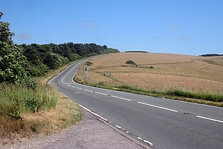
The A259 is a road on the south coast of England passing through Hampshire, West Sussex, East Sussex, and Kent, and is the longest Zone 2 A road in Great Britain. The main part of the road connects Brighton, Peacehaven, Eastbourne, Hastings, Rye, and Folkestone.

<span class="mw-page-title-main">Dymchurch Redoubt</span>

Dymchurch Grand Redoubt is a fortification at Palmarsh on the coast of Kent in England, built during the Napoleonic War as part of a large defensive scheme to protect the country from an expected French invasion.

<span class="mw-page-title-main">Dymchurch</span> Human settlement in England

Dymchurch is a village and civil parish in the Folkestone and Hythe district of Kent, England. The village is located on the coast five miles (8 km) south-west of Hythe, and on the Romney Marsh.

<span class="mw-page-title-main">Walderslade</span> Human settlement in England

Walderslade is a large suburb in Kent in Chatham split between the unitary authority of Medway and the boroughs of Maidstone and Tonbridge & Malling in South East England. It was, until 1998, fully part of Kent and is still ceremonially associated via the Lieutenancies Act. It encompasses almost all the ME5 postcode district.

<span class="mw-page-title-main">Brookland, Kent</span> Human settlement in England

Brookland is a village and civil parish in the Folkestone and Hythe district of Kent, England, about 5 miles (8 km) west of New Romney. According to the 2001 census the parish had a population of 453, increasing to 479 at the 2011 Census. It is located on the A259 road in Romney Marsh and become popular with visitors heading to the Laughing Frog Teas Rooms.

<span class="mw-page-title-main">Dymchurch railway station</span> Railway station in Dymchurch, England

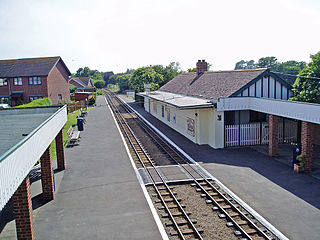
Dymchurch railway station is on the Romney, Hythe and Dymchurch Railway in Kent, England. It is five miles south of Hythe, and surrounded by flat countryside.

<span class="mw-page-title-main">St Mary's Bay railway station</span> Railway station in Kent, England

St. Mary's Bay railway station is a small station in St Mary's Bay, Kent, England, between the larger stations of New Romney and Dymchurch, on the Romney, Hythe and Dymchurch Railway.

<span class="mw-page-title-main">Burmarsh Road railway station</span> Disused railway station in England

Burmarsh Road railway station is a station on the Romney, Hythe and Dymchurch Railway in Kent, England. It is four miles south of Hythe.

<span class="mw-page-title-main">Romney Sands railway station</span> Former railway station in England

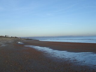
Romney Sands Railway Station is a station on the Romney, Hythe and Dymchurch Railway in Kent, England. It is located on the bleakest part of the Romney Marsh, a shingle peninsula.

<span class="mw-page-title-main">Chidham and Hambrook</span> Human settlement in England

Chidham and Hambrook is a civil parish in the District of Chichester in West Sussex, England located approximately five miles (8 km) west of Chichester, south of the A27 road, near Bosham. Chidham is the ecclesiastical parish, with a slightly different boundary from that of the civil parish.

<span class="mw-page-title-main">Golden Sands Halt railway station</span> Disused railway station in Kent, England

Golden Sands Halt railway station was a private station on the Romney, Hythe and Dymchurch Railway in St Mary's Bay, Kent, England. In the 1990s it was briefly renamed Reunion Halt.

<span class="mw-page-title-main">West Hythe</span> Human settlement in England

West Hythe is a hamlet and former civil parish, now in the parish of Hythe, in the Folkestone and Hythe district, in Kent, England, near Palmarsh and a few miles west of the cinque port town of Hythe. In 2020 it had an estimated population of 566.

<span class="mw-page-title-main">St Mary in the Marsh</span> Human settlement in England

St Mary in the Marsh is a village and civil parish near New Romney in Kent, England, situated in the heart of Romney Marsh in one of its least densely populated areas, with most local amenities available 3 miles away in New Romney or St Mary's Bay at 2 miles. The village centre consists of about forty homes, a few scattered farms and The Star Inn, along with the church of St Mary the Virgin and the St Marys Hut, now closed. St Mary's Bay is also in the parish. A group of villagers have established a charity "St Mary in the Marsh Project Fund" with the aim of building a new community hub.

<span class="mw-page-title-main">Burmarsh</span> Human settlement in England

Burmarsh is a village and civil parish in the Folkestone and Hythe District of Kent, England. The village is located three miles (4.8 km) west of Hythe on the Romney Marsh. The Burmarsh Road connects the village to the once fully operating Burmarsh Road train station. The closest major settlement is Folkestone which is a minimum of 9.5 mile car journey.

<span class="mw-page-title-main">Brookland Halt railway station</span> Disused railway station in England

Brookland Halt was a railway station which served the village of Brookland in Kent, England. The station opened in 1881 and closed in 1967.

Palmarsh is a community in Folkestone and Hythe district, in the County of Kent, England. In origin it was a hamlet on the edge of the Romney Marsh, but modern development to the west of Hythe in a corridor along the A259 coastal road, has led to the joining together of the ancient town and cinque port of Hythe and the rural hamlet of Palmarsh in a single conurbation.

References

  1. "Civil Parish population 2011". Neighbourhood Statistics. Office for National Statistics. Retrieved 20 September 2016.