Stadtprozelten

Last updated
Stadtprozelten
Stadtprozelten, stadszicht met die Kirche Maria Himmelfahrt foto4 2016-08-08 11.26.jpg
View of the town with the Church of the Assumption of the Virgin Mary
DEU Stadtprozelten COA.svg
Location of Stadtprozelten within Miltenberg district
Stadtprozelten in MIL.svgHohe Wart (unincorporated area)ForstwaldHohe BergWeilbachSchneebergNeunkirchenLaudenbachHausen
Germany adm location map.svg
Red pog.svg
Stadtprozelten
Bavaria location map.svg
Red pog.svg
Stadtprozelten
Coordinates: 49°47′N9°25′E / 49.783°N 9.417°E / 49.783; 9.417
Country Germany
State Bavaria
Admin. region Lower Franconia
District Miltenberg
Municipal assoc. Stadtprozelten
Government
   Mayor (202026) Rainer Kroth [1] (CSU)
Area
  Total10.84 km2 (4.19 sq mi)
Elevation
134 m (440 ft)
Population
 (2022-12-31) [2]
  Total1,555
  Density140/km2 (370/sq mi)
Time zone UTC+01:00 (CET)
  Summer (DST) UTC+02:00 (CEST)
Postal codes
97909
Dialling codes 09392
Vehicle registration MIL
Website www.stadtprozelten.de

Stadtprozelten is a town and municipality in the Miltenberg district in the Regierungsbezirk of Lower Franconia (Unterfranken) in Bavaria, Germany [3] and the seat of the Verwaltungsgemeinschaft (municipal association) of Stadtprozelten.

Contents

A traditional, mainly Catholic town, it is known to its inhabitants as Stadtprozle.

Geography

Location

Stadtprozelten lies on the southern edge of the Spessart (range) and on the right bank of the Main in the middle of the south side of the Mainviereck (“Main Square”), 8 km northwest of Wertheim am Main. Stadtprozelten lies directly opposite de:Mondfeld, which is on the left bank of the Main. They are linked by a ferry.

Subdivisions

The Stadtteil of Neuenbuch lies 2 km north of the town centre.

Neighbouring communities

Stadtprozelten is bordered by (from the north, clockwise): Altenbuch, Faulbach, Wertheim (Baden-Württemberg), Dorfprozelten and Eschau.

History

In 1287, Stadtprozelten had its first documentary mention. The former Electoral Mainz Amt passed in 1803 to Prince Primate von Dalberg’s newly formed Principality of Aschaffenburg, with which it passed in 1814 (by this time it had become a department of the Grand Duchy of Frankfurt) to the Kingdom of Bavaria. In the course of administrative reform in Bavaria, the current municipality came into being with the Gemeindeedikt (“Municipal Edict”) of 1818.

650 years of holding town rights were celebrated in 2005. The first documentary mention, however, is not yet fully established beyond doubt.

Government

Town council

The council is made up of 12 council members, not counting the mayor, with seats apportioned thus:

Election year CSU SPD FWG Stadtprozelten-Neuenbuch Total
200884n.a.12 seats
200252512 seats

Elections in 2014:

[4]

Mayor

Rainer Kroth (CSU) was elected mayor in March 2020. [1] He succeeded Claudia Kappes (born 1953, CSU) who was the mayor since 2002, she was re-elected in 2008 and 2014. [5]

Coat of arms

The town’s arms might be described thus: Argent a castle with a gate tower gules and roofs azure, above the gateway the letter B Or, in chief dexter the sun in his glory, and in chief sinister the moon in her increment of the last.

The oldest known town seals come down from the 16th century. The building in the arms might be the old castle held here by the Teutonic Knights. The sun and moon are presumably old town symbols. The letter B comes from another coat of arms dating from 1600 seen on a pane of glass from the town hall. It stands for the town’s former name, Brodselden (the name Stadtprozelten first crops up in 1319).

The arms have been borne at least since the 16th century. [6]

Culture and sightseeing

Buildings

The Henneburg (castle) on the Kuhlberg in Stadtprozelten Burg Henneburg.jpg
The Henneburg (castle) on the Kühlberg in Stadtprozelten
Apothecary Apotheke Stadtprozelten.jpg
Apothecary
Extraordinary performance by the Stadtprozelten Coopers' Dancing Group on the occasion of the historic Town Festival on 9 and 10 July 2005 Schaefflertanz Stadtprozelten.jpg
Extraordinary performance by the Stadtprozelten Coopers’ Dancing Group on the occasion of the historic Town Festival on 9 and 10 July 2005

Overlooking the town is the Henneburg  [ de ] castle ruin on the hill known as the Kühlberg.

Other important monuments in town are:

Regular events

Schäfflertanz

The Schäfflertanz (“Coopers’ Dance”) is put on according to tradition every seven years. The coopers’ group, possibly Germany’s biggest and the only one in white and blue, is made up of well over 60 and up to 90 actors, that is, master coopers, the barrel hoop swinger, dancers, clowns, waiters and the boys who pull the cart. Because it is a group dance, the number of these exclusively male dancers is always a multiple of eight.

This tradition originated in Munich. Beginning about 1830, journeyman coopers brought the dance to other places such as Eggenfelden, Frontenhausen, Geiselhöring, Mainburg, Mühldorf, Murnau, Kelheim, Landshut, Partenkirchen and Wasserburg. In 1887, the Schäfflertanz was put on in Stadtprozelten for the first time. The most recent performance was in 2013.

"Doude Moo"

This event has its roots in the time of the Plague, when dead bodies had to be fetched from the houses. The body gatherers would call out as they went through town "Hejo - doude Moo - moje kommd en annern droo" (roughly, "Hello, dead man, tomorrow it’ll be another’s turn"; this is dialectal, not standard High German).

Nowadays children enjoy the sweets that are thrown out into the street from all the houses as a straw doll is borne ahead of them out of the town and then burnt. "Doude Moo" is always held on the third Sunday before Easter.

The event is known in official circles as "Todemo".

Notable people

Related Research Articles

<span class="mw-page-title-main">Klingenberg am Main</span> Town in Bavaria, Germany

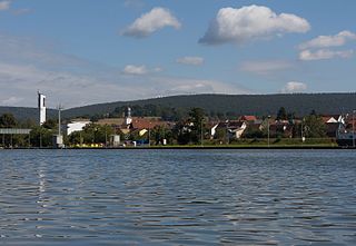
Klingenberg am Main is a town in the Miltenberg district in the Regierungsbezirk of Lower Franconia (Unterfranken) in Bavaria, Germany. It has a population of around 6,200 and is located on both banks of the river Main.

<span class="mw-page-title-main">Mömlingen</span> Municipality in Bavaria, Germany

Mömlingen is a municipality in the Miltenberg district in the Regierungsbezirk of Lower Franconia (Unterfranken) in Bavaria, Germany.

<span class="mw-page-title-main">Obernburg</span> Town in Bavaria, Germany

Obernburg am Main is a town in the Miltenberg district in the Regierungsbezirk of Lower Franconia (Unterfranken) in Bavaria, Germany. It has a population of around 8,500.

<span class="mw-page-title-main">Rothenfels</span> Town in Bavaria, Germany

Rothenfels is a town in the Main-Spessart district in the Regierungsbezirk of Lower Franconia (Unterfranken) in Bavaria, Germany and a member of the Verwaltungsgemeinschaft of Marktheidenfeld. With a population of just around 1,000 it is said to be Bavaria’s smallest town.

<span class="mw-page-title-main">Schlüsselfeld</span> Town in Bavaria, Germany

Schlüsselfeld is a town on the southwestern edge of the Upper Franconian district (Landkreis) of Bamberg

<span class="mw-page-title-main">Kleinwallstadt</span> Municipality in Bavaria, Germany

Kleinwallstadt is a market community in the Miltenberg district in the Regierungsbezirk of Lower Franconia (Unterfranken) in Bavaria, Germany and the seat of the like-named Verwaltungsgemeinschaft.

<span class="mw-page-title-main">Kreuzwertheim</span> Municipality in Bavaria, Germany

Kreuzwertheim is a market town in the Main-Spessart district in the Regierungsbezirk of Lower Franconia (Unterfranken) in Bavaria, Germany and the seat of the Verwaltungsgemeinschaft of Kreuzwertheim. It has around 3,800 inhabitants.

<span class="mw-page-title-main">Partenstein</span> Municipality in Bavaria, Germany

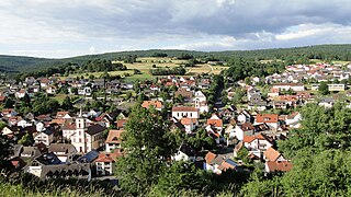
Partenstein is a community in the Main-Spessart district in the Regierungsbezirk of Lower Franconia (Unterfranken) in Bavaria, Germany and the seat of the Verwaltungsgemeinschaft of Partenstein. Partenstein is located on Bundesstraße 276.

<span class="mw-page-title-main">Triefenstein</span> Municipality in Bavaria, Germany

Markt Triefenstein is a market community in the Main-Spessart district in the Regierungsbezirk of Lower Franconia (Unterfranken) in Bavaria, Germany. It was created in 1978 out of the villages Homburg am Main, Lengfurt, Rettersheim and Trennfeld.

<span class="mw-page-title-main">Collenberg</span> Municipality in Bavaria, Germany

Collenberg is a community in the Miltenberg district in the Regierungsbezirk of Lower Franconia (Unterfranken) in Bavaria, Germany. It has a population of about 2,400.

<span class="mw-page-title-main">Dorfprozelten</span> Municipality in Bavaria, Germany

Dorfprozelten is a municipality in the Miltenberg district in the Regierungsbezirk of Lower Franconia (Unterfranken) in Bavaria, Germany. It is one of the oldest settlements on the Lower Main. Sandstone quarrying was a major industry once. The village has also long been known as the home of people involved in inland (river) navigation. Today, Dorfprozelten has a population of close to 1,800.

<span class="mw-page-title-main">Eichenbühl</span> Municipality in Bavaria, Germany

Eichenbühl is a community in the Miltenberg district in the Regierungsbezirk of Lower Franconia (Unterfranken) in Bavaria, Germany.

<span class="mw-page-title-main">Eschau</span> Municipality in Bavaria, Germany

Eschau is a market community in the Miltenberg district in the Regierungsbezirk of Lower Franconia (Unterfranken) in Bavaria, Germany. It has a population of around 3,800.

<span class="mw-page-title-main">Faulbach</span> Municipality in Bavaria, Germany

Faulbach is a municipality in the Miltenberg district in the Regierungsbezirk of Lower Franconia (Unterfranken) in Bavaria, Germany. It has a population of around 2,600.

<span class="mw-page-title-main">Großheubach</span> Municipality in Bavaria, Germany

Großheubach is a market community in the Miltenberg district in the Regierungsbezirk of Lower Franconia (Unterfranken) in Bavaria, Germany.

<span class="mw-page-title-main">Hausen, Miltenberg</span> Municipality in Bavaria, Germany

Hausen is a community in the Miltenberg district in the Regierungsbezirk of Lower Franconia (Unterfranken) in Bavaria, Germany and a member of the Verwaltungsgemeinschaft of Kleinwallstadt.

<span class="mw-page-title-main">Kleinheubach</span> Municipality in Bavaria, Germany

Kleinheubach is a market community in the Miltenberg district in the Regierungsbezirk of Lower Franconia (Unterfranken) in Bavaria, Germany and the seat of the like-named Verwaltungsgemeinschaft. As of the 2011 census, it has a population of around 3,614.

<span class="mw-page-title-main">Röllbach</span> Municipality in Bavaria, Germany

Röllbach is a municipality in the Miltenberg district in the Regierungsbezirk of Lower Franconia (Unterfranken) in Bavaria, Germany and a member of the Verwaltungsgemeinschaft of Mönchberg.

<span class="mw-page-title-main">Weilbach, Germany</span> Municipality in Bavaria, Germany

Weilbach is a market municipality in the Miltenberg district in the Regierungsbezirk of Lower Franconia (Unterfranken) in Bavaria, Germany.

<span class="mw-page-title-main">Erlenbach bei Marktheidenfeld</span> Municipality in Bavaria, Germany

Erlenbach bei Marktheidenfeld is a community in the Main-Spessart district in the Regierungsbezirk of Lower Franconia in Bavaria, Germany and a member of the Verwaltungsgemeinschaft of Marktheidenfeld. It has given itself the title Weinort mit Herz – Wine Town with Heart.

References

  1. 1 2 Liste der ersten Bürgermeister/Oberbürgermeister in kreisangehörigen Gemeinden, Bayerisches Landesamt für Statistik, 15 July 2021.
  2. Genesis Online-Datenbank des Bayerischen Landesamtes für Statistik Tabelle 12411-003r Fortschreibung des Bevölkerungsstandes: Gemeinden, Stichtag (Einwohnerzahlen auf Grundlage des Zensus 2011)
  3. "trip.com".
  4. http://www.stadtprozelten.de/index.asp?NAVIID={73D0D07E-83FE-4057-AF6D-E197FCD73E38}
  5. "Wahlen".
  6. Description and explanation of Stadtprozelten’s arms