
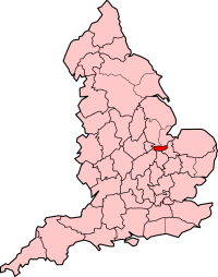
The City of Peterborough, commonly known as Peterborough, is a unitary authority district with city status in the ceremonial county of Cambridgeshire, England. The area is named after its largest settlement, Peterborough but also covers a wider area of outlying villages and hamlets.
The Soke of Peterborough is a historic area of England associated with the City and Diocese of Peterborough, but considered part of Northamptonshire. The Soke was also described as the Liberty of Peterborough, or Nassaburgh hundred, and comprised, besides Peterborough, about thirty parishes.

East Cambridgeshire is a local government district in Cambridgeshire, England. Its council is based in the city of Ely. The district also contains the towns of Littleport and Soham and surrounding rural areas, including parts of the Fens.

Stanground is a residential area of Peterborough, in the ceremonial county of Cambridgeshire, England. For electoral purposes, it comprises the Stanground South and Fletton & Stanground wards in the North West Cambridgeshire constituency.

A civil parish is a country subdivision, forming the lowest unit of local government in England. There are 264 civil parishes in the ceremonial county of Cambridgeshire, most of the county being parished; Cambridge is completely unparished; Fenland, East Cambridgeshire, South Cambridgeshire and Huntingdonshire are entirely parished. At the 2001 census, there were 497,820 people living in the parishes, accounting for 70.2 per cent of the county's population.

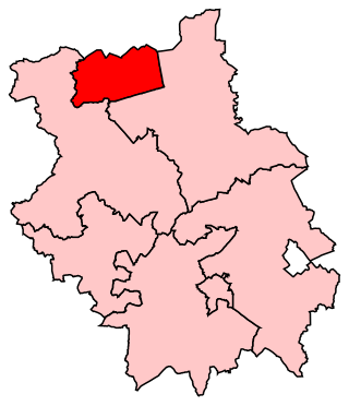
North West Cambridgeshire is a county constituency represented in the House of Commons of the Parliament of the United Kingdom since 2005 by Shailesh Vara of the Conservative Party. It elects one Member of Parliament (MP) by the first past the post system of election.
Peterborough is a borough constituency represented in the House of Commons of the Parliament of the United Kingdom since 2019 by Paul Bristow of the Conservative Party.

Barham is a village and former civil parish, now in the parish of Barham and Woolley, in Cambridgeshire, England. Barham lies approximately 7 miles (11 km) west of Huntingdon. Barham is situated within Huntingdonshire which is a non-metropolitan district of Cambridgeshire as well as being a historic county of England. In 1931 the parish had a population of 34.

Farcet is a village and civil parish in Cambridgeshire, England. Farcet lies approximately 2 miles (3 km) south of Peterborough city centre, between Yaxley and the Peterborough suburb of Old Fletton. Farcet is situated within Huntingdonshire which is a non-metropolitan district of Cambridgeshire as well as being a historic county of England.

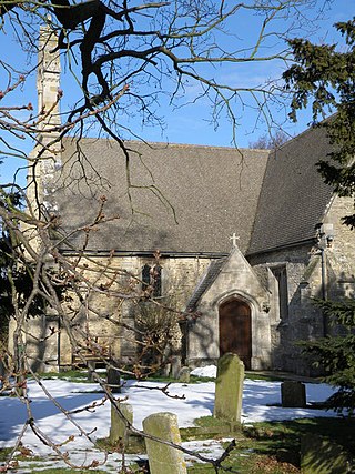
Hamerton is a village in and former civil parish, now in the parish of Hamerton and Steeple Gidding, in Cambridgeshire, England. Hamerton lies approximately 8 miles (13 km) north-west of Huntingdon. Hamerton is situated within Huntingdonshire which is a non-metropolitan district of Cambridgeshire as well as being a historic county of England. Hamerton Zoo is on the north side of the village. The village has a church dedicated to All Saints. In 2001 the parish had a population of 87.

Old Fletton was an urban district in the county of Huntingdonshire and then Huntingdon and Peterborough. The urban district was abolished in 1974 under the Local Government Act 1972, and now forms part of the city of Peterborough in Cambridgeshire.
Folksworth is a village and former civil parish, now in the parish of Folksworth and Washingley, in Cambridgeshire, England. Folksworth lies approximately 5 miles (8 km) south-west of Peterborough, just off the A1(M). Folksworth is situated within Huntingdonshire which is a non-metropolitan district of Cambridgeshire as well as being a historic county of England. In 1931 the parish had a population of 120.

Fletton is an area of the city of Peterborough, in the Peterborough district, in the ceremonial county of Cambridgeshire, England, south of the River Nene.
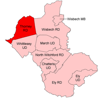
Thorney was a rural district in England from 1894 to 1974, situated to the east of Peterborough.

Paston is a residential area and electoral ward in the city of Peterborough, in the ceremonial county of Cambridgeshire, England.

Woodston is a largely residential and industrial area of the city of Peterborough, in the ceremonial county of Cambridgeshire, England. For electoral purposes, it forms part of Fletton ward in North West Cambridgeshire constituency. Oundle Road runs through most of Woodston into the Ortons.

Peterborough City Council is the local authority for Peterborough in the East of England. It is a unitary authority, having the powers of a non-metropolitan county and district council combined. The City was incorporated as a municipal borough in 1874; from 1888, it fell within the jurisdiction of the Soke of Peterborough county council and from 1965, Huntingdon and Peterborough county council. In 1974, it was replaced by a wholly new non-metropolitan district, broadly corresponding to the Soke, in the new enlarged Cambridgeshire. In 1998, Peterborough became independent of Cambridgeshire as a unitary authority, but the city continues to form part of that county for ceremonial purposes as defined by the Lieutenancies Act 1997.

Caldecote is a village and former civil parish, now in the parish of Denton and Caldecote, in Cambridgeshire, England. Caldecote lies approximately 7 miles (11 km) south-west of Peterborough. Caldecote is situated within Huntingdonshire which is a non-metropolitan district of Cambridgeshire as well as being a historic county of England. In 1931 the parish had a population of 27.

Denton is a hamlet and former civil parish, now in the parish of Denton and Caldecote, in Cambridgeshire, England. Denton lies approximately 11 miles (18 km) north-west of Huntingdon. Denton is situated within Huntingdonshire which is a non-metropolitan district of Cambridgeshire as well as being a historic county of England. Denton has approximately 12 houses. In 1931 the parish had a population of 76.
Washingley is a hamlet and former civil parish, now in the parish of Folksworth and Washingley, in Cambridgeshire, England. Washingley lies approximately 7 miles (11 km) south-west of Peterborough, near Folksworth. Washingley is situated within Huntingdonshire which is a non-metropolitan district of Cambridgeshire as well as being a historic county of England. In 1931 the parish had a population of 69.

