Strada statale 4 Via Salaria

Last updated

Strada Statale 4 Italia.svg

State Highway 4
Strada statale 4
Salaria
Italia - mappa strada statale 4.svg
Route information
Maintained by ANAS
Length208.2 km (129.4 mi)
reduced to 175 km since the Ascoli-Porto d'Ascoli trait was declassed to provincial road
Existed1928–present
Major junctions
FromCity centre of Rome
  Tangenziale Est and GRA in Rome; Autostrada A1 at Settebagni; SS 313 in Passo Corese; SS 636 di Palombara at Borgo Quinzio; SS 79 Ternana and SS 578 Salto Cicolana in Rieti; SS 17 in Antrodoco; SS 471 di Leonessa at Posta; SS 260 Picente at Amatrice; SS 685 delle Tre Valli Umbre at Arquata del Tronto; Raccordo autostradale 11 and SS 81 Piceno Aprutina at Ascoli Piceno
To SS 16 Adriatica at Porto d'Ascoli
Location
Regions Lazio, Marche
Highway system
Strade Statali of Italy
Strada Statale 3 Italia.svgSS3SS5Strada Statale 5 Italia.svg

Strada statale 4 Via Salaria is an Italian state highway, linking Rome to the Adriatic sea passing through Rieti and Ascoli Piceno. Its route retraces that of the ancient Via Salaria Roman road. It is a single carriageway highway for most of its route.

Contents

Route

Rome to Rieti

SS 4 as seen near Poggio San Lorenzo Strada Statale 4 Via Salaria - km 58 (2).JPG
SS 4 as seen near Poggio San Lorenzo

Strada statale 4 Via Salaria starts Northeast of Rome, just outside the Aurelian Walls, where until 1921 Porta Salaria was located to control access to the city. The initial stretch of SS 4 is more similar to an urban road than to a highway, as the area has now become densely populated and buildings have been raised by the roadside. After four kilometres SS4 meets Tangenziale Est di Roma and, from that point on, becomes a busy dual carriageway urban road, filled by people leaving or entering the city.

In the Castel Giubileo neighborhood, SS4 exits the city of Rome and meets Grande Raccordo Anulare (GRA), where most of the traffic flows. Immediately after, the road returns a single carriageway highway; in fact the subsequent 20 kilometer stretch, from the GRA to Passo Corese, has seen his importance reduced since the 6-lane Autostrada A1 runs parallel to it and absorbs most of the long-distance traffic. Nevertheless, SS4 remains important to many mid-sized towns in Rome's hinterland, such as Settebagni, Monterotondo and Mentana.

Passo Corese marks both the point where SS4 enters the Province of Rieti and the point where it diverges from Autostrada A1, receiving from it all traffic to the Adriatic. The road here leaves the Tiber valley and ventures into the more hilly Sabina region, commencing its long, gradual ascent to the Apennines. For this reason, SS4 had once a rather rough course from here on, with tight bends and continuous rises and descents; current SS4 is a completely new road (constructed in the 1960s to replace the old one from Passo Corese to Rieti), much more straight and wide, albeit still with a single carriageway.

The 4.5 km (2.8 mi), dual carriageway road tunnel "Colle Giardino", near Rieti SS 4 Salaria - galleria Colle Giardino - imbocco nord.jpg
The 4.5 km (2.8 mi), dual carriageway road tunnel "Colle Giardino", near Rieti

As the road passes the Sabine mountains, it reaches an altitude of 400 metres above sea level at Osteria Nuova and it descents into a narrow valley, then rises again until reaching 570 metres in the village of Ornaro, and finally descents.

6 km (3.7 mi) south of province capital Rieti the road becomes a dual carriageway road; the long "Colle Giardino" road tunnel allows the road to leave Sabine mountains behind and to enter the Rieti plain (400 metres on sea level) where the city is settled.

Rieti to the Adriatic

Dual carriageway trait in Rieti Statale Salaria - variante di Rieti da Salaria vecchia (dir. Roma) 02.jpg
Dual carriageway trait in Rieti

In Rieti SS4 turns sharply into East, quickly leaves the Rieti plain and prosecutes in the Velino valley. Shortly before Cittaducale, the road returns a single carriageway and pretty narrow road, which still needs to be uprated and follows a similar path to the ancient Roman road. While slightly ascending, SS4 reaches the spa town of Cotilia and then Antrodoco, where it joins State Highway 17 to L'Aquila.

The Velino viaduct, in the Gole del Velino canyon Strada statale 4 Via Salaria - viadotto Velino (1).jpg
The Velino viaduct, in the Gole del Velino canyon

In Antrodoco (470 metres on sea level) the road follows the river's valley, bending to the north and entering the narrow "Gole del Velino" canyon. Here SS4 becomes similar to a mountain road, since bends become more tight and the ascent more steep; but halfway through the canyon, a recently uprated stretch of the road begins, where tunnels and viaducts make the road smoother albeit still with a single carriageway.

In Posta, at 700 metres above sea level, SS4 leaves the canyon and keeps going up in a broader plateau. Shortly after Cittareale the highway reaches its upper point, the Torrita Pass, at around 1010 metres on the sea level.

From here on the roads descents following the course of the narrow Tronto valley. Soon after Amatrice and Accumoli, the road leaves Lazio and enters the region of Marche. Passing through Arquata del Tronto (780 metres on sea level) and Acquasanta Terme (390 metres), SS4 keeps descending until it reaches province capital Ascoli Piceno (150 metres on sea level).

After Ascoli the road continues towards the Adriatic sea with a rather winding path, where it ends in a junction with SS 16 Adriatica and the Autostrada A14 in Porto d'Ascoli (near San Benedetto del Tronto). Still, such trait has been recently declassed to provincial road, since it has been replaced by Raccordo autostradale 11, a more modern dual carriageway road.

Future interventions

Today SS4 is a busy road between Rieti and Passo Corese, as it is the main road link between Rieti and Rome; motorists use it to reach the Autostrada A1 in Passo Corese and continue towards Rome in the more modern road. In this trait SS4 has a single, albeit reasonably wide carriageway, which was constructed in the 1960s in place of an earlier, less smooth road. [1] For this reason, Italian Government plans to make SS4 a dual carriageway road between Rieti and Passo Corese, but around 1.5 billion euros are needed [2] and it is not known when funds will be granted.

Uprating of the trait from Cittaducale to Posta, where the carriageway is rather narrow and the road climbs up the Apennine mountains, is also planned to make the carriageway wider and less winding - even if the road will remain with a single carriageway. The first part of these road works started in 2005 on the Posta-Micigliano stretch [3] and are currently underway.

Related Research Articles

Apennine Mountains Mountain ranges stretching the length of Italy

The Apennines or Apennine Mountains are a mountain range consisting of parallel smaller chains extending c. 1,200 km (750 mi) along the length of peninsular Italy. In the northwest they join with the Ligurian Alps at Altare. In the southwest they end at Reggio di Calabria, the coastal city at the tip of the peninsula. Since 2000 the Environment Ministry of Italy, following the recommendations of the Apennines Park of Europe Project, has been defining the Apennines System to include the mountains of north Sicily, for a total distance of 1,500 kilometres (930 mi). The system forms an arc enclosing the east side of the Ligurian and Tyrrhenian Seas.

Marche Region of Italy

Marche or The Marches is one of the twenty regions of Italy. The name of the region derives from the plural name of marca, originally referring to the medieval March of Ancona and nearby marches of Camerino and Fermo.

Ascoli Piceno Comune in Marche, Italy

Ascoli PicenoItalian: [ˈaskoli piˈtʃɛːno](listen); Latin: Asculum) is a town and comune in the Marche region of Italy, capital of the province of the same name. Its population is around 46,846 but the urban area of the city has more than 93,000.

Dual carriageway

A dual carriageway or divided highway is a class of highway with carriageways for traffic travelling in opposite directions separated by a central reservation. Roads with two or more carriageways which are designed to higher standards with controlled access are generally classed as motorways, freeways, etc., rather than dual carriageways.

Via Salaria

The Via Salaria was an ancient Roman road in Italy.

Rieti Comune in Lazio, Italy

Rieti is an ancient town and comune in Lazio, central Italy, with a population of 47,700. It is the administrative seat of the province of Rieti and see of the diocese of Rieti, as well as the modern capital of the Sabina region.

San Benedetto del Tronto Comune in Marche, Italy

San Benedetto del Tronto is a city and comune in Marche, Italy. Part of an urban area with 100,000 inhabitants, it is one of the most densely populated areas along the Adriatic Sea coast.It is the most populated city in Province of Ascoli Piceno, with 47,560. Its port is one of the biggest on the Adriatic; it is the most important centre of Riviera of the Palms, with over 8,000 Phoenix canariensis, Washingtonia and P. sylvestris plants.

Antrodoco Comune in Lazio, Italy

Antrodoco is a town and comune in the province of Rieti, in the Lazio region of central Italy. The name derives from the Latin Interocrea.

Monti della Laga

Monti della Laga is a mountain range in the central Apennines of Italy. Their ruggedness and inaccessibility makes them one of the lesser known areas of the Italian peninsula.

Grande Raccordo Anulare Road in Italy

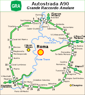
The GRA or Grande Raccordo Anulare is a toll-free, ring-shaped 68.2 kilometres (42.4 mi) long orbital motorway that encircles Rome. GRA is one of the most important roads in Rome, and traffic reaches 160,000 vehicles per day as of 2011.

Autostrada A24 (Italy)

The Autostrada A24 or “Parks Motorway”, is a highway connecting Rome to the Adriatic Sea. Starting from GRA and ending to Teramo, the A24 create a new historical linkage between Rome and the insidious apennine mountains, alongside long-time roads Salaria, Flaminia and Tiburtina Valeria.

Autostrada A91 (Italy)

The Autostrada A91, also called Autostrada Roma-Fiumicino, is an Italian motorway which connects Rome to the Fiumicino Airport.

The GRAP is the orbital motorway surrounding Padua, northern Italy. It is also called Tangenziale di Padova.

Tangenziale di Venezia

The Tangenziale di Mestre, or Autostrada A57, was opened to traffic on 3 September 1972 in northern Italy.

Adriatic–Ionian motorway

Adriatic–Ionian motorway or the Blue Corridor, is a future motorway that will stretch along the entire eastern shore of the Adriatic and Ionian seas, spanning the western coast of the Balkan peninsula from Italy in the north through Croatia, Montenegro, Albania to Greece in the south.

Durrës-Kukës Highway

The A1, also commonly Rruga e Kombit or SH10, is the longest and only toll motorway in Albania, stretching 114 kilometres (71 mi) in the counties of Lezhë and Kukës. It consists for the most part of two traffic lanes and an emergency lane in each driving direction separated by a central reservation.

Passo Corese Frazione in Lazio, Italy

Passo Corese is an Italian town and hamlet (frazione) of Fara in Sabina, a municipality in the province of Rieti, Lazio. In 2011 it had a population of 3,573.

Highways in Albania

The Highways in Albania are the central state and main transport network in Albania. The motorways and expressways are both part of the national road network. The motorways are primary roads with a speed limit of 110 kilometres per hour (68 mph). They have white on green road signs such as in Italy and other countries nearby. The expressways are the secondary roads, also dual carriageways, but without an emergency lane. They have a speed limit of 90 kilometres per hour (56 mph). They have white on blue road signs.

Terni–Sulmona railway

The Terni–Sulmona railway is a regional railway line in central Italy, managed by Rete Ferroviaria Italiana. It links three regions, Umbria, Lazio and Abruzzo, and three provincial capitals: Terni, Rieti and L'Aquila. Together with the Sulmona–Isernia railway it forms a north–south corridor through the Apennines in central Italy. Its route is the result of two unfinished railways that had to meet in Rieti: the Pescara–L'Aquila–Rome line, and the Terni–Avezzano–Roccasecca line.

Rieti Valley

The Rieti Valley or Rieti Plain is a small plain in central Italy, where lies the city of Rieti, Lazio. It is also known as Sacred Valley and Holy Valley since saint Francis of Assisi lived here for many years and erected four shrines, which have become the destination of pilgrims.

References

  1. "Relazione di sintesi". Ministero dell'Ambiente. 21 June 2007. Retrieved 8 March 2016.
  2. Camera dei deputati - Sistema Informativo Legge Opere Strategiche
  3. "Via all'appalto del primo lotto della Salaria". Il Tempo, Rieti edition. 12 May 2005. Archived from the original on 25 March 2016. Retrieved 17 March 2016.