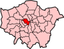
The Metropolitan Board of Works (MBW) was the principal instrument of London-wide government from December 1855 until the establishment of the London County Council in March 1889. Its principal responsibility was to provide infrastructure to cope with London's rapid growth, which it accomplished with varying degrees of success. The MBW was an appointed rather than elected body. This lack of accountability made it unpopular with Londoners, especially in its latter years when it fell prey to corruption.

The Metropolitan Borough of Westminster was a metropolitan borough in the County of London, England, from 1900 to 1965.

Islington was a civil parish and metropolitan borough in London, England. It was an ancient parish within the county of Middlesex, and formed part of The Metropolis from 1855. The parish was transferred to the County of London in 1889 and became a metropolitan borough in 1900. It was amalgamated with the Metropolitan Borough of Finsbury to form the London Borough of Islington in Greater London in 1965.

Westminster City Council is the local authority for the City of Westminster in Greater London, England. The city is divided into 20 wards, each electing three councillors. The council is currently composed of 41 Conservative Party members and 19 Labour Party members. The council was created by the London Government Act 1963 and replaced three local authorities: Paddington Metropolitan Borough Council, St Marylebone Metropolitan Borough Council and Westminster Borough Council.
The Metropolis Management Act 1855 was an Act of the Parliament of the United Kingdom that created the Metropolitan Board of Works, a London-wide body to co-ordinate the construction of the city's infrastructure. The Act also created a second tier of local government consisting of parish vestries and district boards of works. The Metropolitan Board of Works was the forerunner of the London County Council.
Bermondsey was a parish in the metropolitan area of London, England.

Holborn was a local government district in the metropolitan area of London to the north west of the City of London from 1855 to 1900.

St Giles District was a local government district in the metropolitan area of London, England from 1855 to 1900. The district was created by the Metropolis Management Act 1855, and comprised the civil parish of St Giles in the Fields and St George Bloomsbury, Middlesex: the two parishes had been combined for civil purposes in 1774. The district was abolished in 1900 and its former area became part of the Metropolitan Borough of Holborn. The civil parish was abolished in 1930. It is now part of the London Borough of Camden.

St George Hanover Square was a civil parish in the metropolitan area of London, England. The creation of the parish accompanied the building of the St George's Hanover Square Church, constructed by the Commission for Building Fifty New Churches to meet the demands of the growing population. The parish was formed in 1724 from part of the quite early medieval parish of Saint Martin in the Fields in the consequent Liberty of Westminster, hundred of Ossulstone and county of Middlesex. It included some of the most fashionable areas of the West End of London, including Belgravia and Mayfair. Civil parish administration, known as a select vestry, was dominated by members of the British nobility until the parish adopted the Vestries Act 1831. The vestry was reformed again in 1855 by the Metropolis Management Act. In 1889 the parish became part of the County of London and the vestry was abolished in 1900, replaced by Westminster City Council. The parish continued to have nominal existence until 1922. As created, it was a parish for both church and civil purposes, but the boundaries of the ecclesiastical parish were adjusted in 1830, 1835 and 1865.

Westminster St James was a civil parish in the metropolitan area of London, England. The creation of the parish followed the building of the Church of St James, Piccadilly in 1684. After several failed attempts, the parish was formed in 1685 from part of the ancient parish of St Martin in the Fields in the Liberty of Westminster and county of Middlesex. It included part of the West End of London, taking in sections of Soho, Mayfair and St James's. Civil parish administration was in the hands of a select vestry until the parish adopted the Vestries Act 1831. The vestry was reformed again in 1855 by the Metropolis Management Act. In 1889 the parish became part of the County of London and the vestry was abolished in 1900, replaced by Westminster City Council. The parish continued to have nominal existence until 1922.
St Martin-in-the-Fields was a civil parish in the metropolitan area of London, England. It took its name from the church of St Martin-in-the-Fields and was within the Liberty of Westminster. It included within its boundaries the former extra-parochial areas of Buckingham Palace and St James's Palace.
St Paul Covent Garden was a civil parish in the metropolitan area of London, England. The former area of the parish now corresponds to the Covent Garden market and surrounding streets in the City of Westminster.
St Anne Within the Liberty of Westminster, also known as St Anne Soho, was a civil parish in the metropolitan area of London, England. The creation of the parish accompanied the building of St Anne's Church, Soho to meet the demands of the growing population. The parish was formed in 1687 from part of the ancient parish of St Martin in the Fields in the Liberty of Westminster and county of Middlesex. It included the eastern section of the contemporary districts of Soho to the north of Shaftesbury Avenue and Chinatown to the south of it. Initially controlled by a select vestry, the parish was governed by an open vestry of all inhabitants until 1855, when the vestry was superseded for most purposes by the Strand District Board of Works. In 1889 the parish became part of the County of London and in 1900 the local authority became Westminster City Council. The parish continued to have nominal existence until 1922.
St Margaret was an ancient parish in the City and Liberty of Westminster and the county of Middlesex. It included the core of modern Westminster, including the Palace of Westminster and the area around, but not including Westminster Abbey. It was divided into St Margaret's and St John's in 1727, to coincide with the building of the Church of St John the Evangelist, constructed by the Commission for Building Fifty New Churches in Smith Square to meet the demands of the growing population, but there continued to be a single vestry for the parishes of St Margaret and St John. This was reformed in 1855 by the Metropolis Management Act, and the two parishes formed the Westminster District until 1887. St Margaret and St John became part of the County of London in 1889. The vestry was abolished in 1900, to be replaced by Westminster City Council, but St Margaret and St John continued to have a nominal existence until 1922.
Plumstead (1855–1894) and then Lee (1894–1900) was a local government district within the metropolitan area of London from 1855 to 1900. It was formed as the Plumstead district by the Metropolis Management Act 1855 and was governed by the Plumstead District Board of Works, which consisted of elected vestrymen.

Greenwich was a local government district within the metropolitan area of London, England from 1855 to 1900. It was formed by the Metropolis Management Act 1855 and was governed by the Greenwich District Board of Works, which consisted of elected vestrymen.
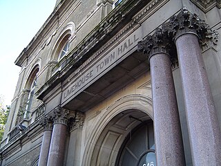
Limehouse was a local government district within the metropolitan area of London, England from 1855 to 1900.
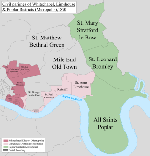
Whitechapel was a local government district within the metropolitan area of London, England from 1855 to 1900.

St Saviour's was a local government district within the metropolitan area of London, England from 1855 to 1900. It was formed by the Metropolis Management Act 1855 and was governed by the St Saviour's District Board of Works, which consisted of elected vestrymen.
The Liberty of Glasshouse Yard was an extra-parochial liberty adjacent to the City of London. The liberty took its name from a glass manufacturing works established there. The area now forms part of the London Borough of Islington.