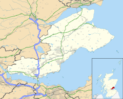
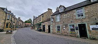
Kinglassie is a small village and parish in central Fife, Scotland. It is located two miles southwest of Glenrothes. It has a population of around 1,900 (mid-2020 est.) The civil parish has a population of 22,543.

East Kilbride is the largest town in South Lanarkshire in Scotland and the country's sixth-largest locality by population. It was also designated Scotland's first new town on 6 May 1947. The area lies on a raised plateau to the south of the Cathkin Braes, about eight miles southeast of Glasgow and close to the boundary with East Renfrewshire.

Uphall is a village in West Lothian, Scotland. It is a swiftly growing village in a conurbation with Broxburn to the east, Dechmont to the west and the major town of Livingston to the south west. Uphall is 30 miles from Glasgow and 14 miles from Edinburgh in the Scottish Lowlands. Uphall Station and Pumpherston are separate villages that lie to the south of Uphall.
Cupar is a town, former royal burgh and parish in Fife, Scotland. It lies between Dundee and Glenrothes. According to a 2011 population estimate, Cupar had a population around 9,000, making it the ninth-largest settlement in Fife, and the civil parish a population of 11,183. It is the historic county town of Fife, although the council now sits at Glenrothes.
Bearsden is a town in East Dunbartonshire, Scotland, on the northwestern fringe of Greater Glasgow. Approximately 6 miles (10 km) from Glasgow City Centre, the town is effectively a suburb, and its housing development coincided with the 1863 introduction of a railway line. The town was named after Bearsden railway station, which was named after a nearby cottage.

Prestwick is a town in South Ayrshire on the west coast of Ayrshire in Scotland about 30 miles southwest of Glasgow. It adjoins the larger town of Ayr to the south on the Firth of Clyde coast, the centre of which is about two miles south, and the small village of Monkton to the north. It had a population of 14,901 at the 2011 census.

Houston, is a village in the council area of Renfrewshire and the larger historic county of the same name in the west central Lowlands of Scotland.
Leven is a seaside town in Fife, set in the east Central Lowlands of Scotland. It lies on the coast of the Firth of Forth at the mouth of the River Leven, 8.1 miles (13.0 km) north-east of the town of Kirkcaldy and 6.4 miles (10.3 km) east of Glenrothes.

Ponteland is a large village and civil parish in Northumberland, England, 9+1⁄2 miles (15 km) north of Newcastle upon Tyne. The name means "island in the Pont", after the River Pont which flows from west to east and joins the River Blyth further downstream, before flowing into the North Sea. Newcastle Airport is 1+1⁄2 miles (2.5 km) to the south of the village.
Kilmacolm is a village and civil parish in the Inverclyde council area, and the historic county of Renfrewshire in the west central Lowlands of Scotland. It lies on the northern slope of the Gryffe Valley, 7+1⁄2 miles southeast of Greenock and around 15 miles (24 km) west of the city of Glasgow. The village has a population of around 4,000 and is part of a wider civil parish which covers a large rural hinterland of 15,000 hectares containing within it the smaller settlement of Quarrier's Village, originally established as a 19th-century residential orphans' home.
Balerno is a village on the outskirts of Edinburgh, Scotland situated 8 miles south-west of the city centre, next to Currie and then Juniper Green. Traditionally in the county of Midlothian it now administratively falls within the jurisdiction of the City of Edinburgh Council. The village lies at the confluence of the Water of Leith and the Bavelaw Burn. In the 18th and 19th century, the area was home to several mills using waterpower. In the 20th century, the mills closed and the village now forms a residential suburb of Edinburgh.

Burnside is a mostly residential area in the town of Rutherglen in South Lanarkshire, Scotland. Including the neighbourhoods of High Burnside and High Crosshill, respectively south and north-west of its main street, it borders Overtoun Park in Rutherglen plus several other residential areas of the town, as well as western parts of neighbouring Cambuslang.

Mid Calder is a village in West Lothian, Scotland. It is located on a steep hill overlooking the River Almond and Calder Wood, around 15 miles (24 km) west of Edinburgh. The settlement has been on a major crossroads since its origin some time in the 11th century.

Newmachar is a village in Aberdeenshire, Scotland about 10 miles (16 km) to the north-west of Aberdeen.

Torphichen is a historic small village located north of Bathgate in West Lothian, Scotland. The village is approximately 18 miles west of Edinburgh, 7 miles south-east of Falkirk and 4 miles south-west of Linlithgow. The village had a population of 570 in the and a population of 710 in 2016. Torphichen's placename may be Gaelic in origin, e.g., "Tóir Féichín", Tor Fithichean, or Brythonic "tref fechan".

Blackburn is a rapidly growing village northwest of Aberdeen, Scotland, and is situated in Aberdeenshire. Local amenities include an industrial estate, primary school, nursing home, post office, Starbucks Drive Thru, local Co-op and a community hall which was publicly opened by The Princess Royal on 2 March 2005.
Chapelhall is a village outside the town of Airdrie in North Lanarkshire, Scotland. With house building, the distinction between Airdrie and Chapelhall is being eroded. Established as a small mining village in the 19th century, it now has population of around 6,560. Chapelhall is situated just off the M8 motorway 13 miles (21 km) east of Glasgow city centre and around 33 miles (53 km) west of Edinburgh. Chapelhall is also near to many of Lanarkshire's main towns, such as Bellshill, Coatbridge, Motherwell, Hamilton and Cumbernauld, as well as being around 3 miles (4.8 km) away from Airdrie town centre. The Eurocentral freight village/industrial estate is just a mile or so away and employs people from around Lanarkshire, Glasgow and West Lothian. The rail-freight village links with Grangemouth docks 28 miles (45 km) away,.

Kingskettle or often simply Kettle is a village and parish in Fife, Scotland. Encompassed by the Howe of Fife, the village is approximately 5.5 miles (9 km) southwest of the nearest town, Cupar, and 22 miles (35 km) north of Edinburgh. According to the 2011 Census for Scotland, the Kettle parish had a population of 1,645, of which 1,002 lived in the village.
Gauldry, locally sometimes The Gauldry, is a village in Fife, Scotland. It is located 3 kilometres (1.9 mi) southwest of Newport on Tay, 2 kilometres (1.2 mi) south-east of Balmerino, and 1 kilometre (0.62 mi) south of Bottomcraig.
Pitlessie is a small village in Cults, Fife, Scotland. It is roughly 4+1⁄2 miles (7 km) southwest of the nearest large town, Cupar, and 23 miles north of Edinburgh. It had an estimated population of 325 in 2010.