Geology is a branch of natural science concerned with the Earth and other astronomical objects, the rocks of which it is composed, and the processes by which they change over time. Modern geology significantly overlaps all other Earth sciences, including hydrology. It is integrated with Earth system science and planetary science.

The geologic time scale or geological time scale (GTS) is a representation of time based on the rock record of Earth. It is a system of chronological dating that uses chronostratigraphy and geochronology. It is used primarily by Earth scientists to describe the timing and relationships of events in geologic history. The time scale has been developed through the study of rock layers and the observation of their relationships and identifying features such as lithologies, paleomagnetic properties, and fossils. The definition of standardized international units of geologic time is the responsibility of the International Commission on Stratigraphy (ICS), a constituent body of the International Union of Geological Sciences (IUGS), whose primary objective is to precisely define global chronostratigraphic units of the International Chronostratigraphic Chart (ICC) that are used to define divisions of geologic time. The chronostratigraphic divisions are in turn used to define geochronologic units.

Sedimentary basins are region-scale depressions of the Earth's crust where subsidence has occurred and a thick sequence of sediments have accumulated to form a large three-dimensional body of sedimentary rock. They form when long-term subsidence creates a regional depression that provides accommodation space for accumulation of sediments. Over millions or tens or hundreds of millions of years the deposition of sediment, primarily gravity-driven transportation of water-borne eroded material, acts to fill the depression. As the sediments are buried, they are subject to increasing pressure and begin the processes of compaction and lithification that transform them into sedimentary rock.

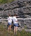
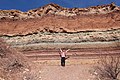
Stratigraphy is a branch of geology concerned with the study of rock layers (strata) and layering (stratification). It is primarily used in the study of sedimentary and layered volcanic rocks. Stratigraphy has three related subfields: lithostratigraphy, biostratigraphy, and chronostratigraphy.

Geochronology is the science of determining the age of rocks, fossils, and sediments using signatures inherent in the rocks themselves. Absolute geochronology can be accomplished through radioactive isotopes, whereas relative geochronology is provided by tools such as paleomagnetism and stable isotope ratios. By combining multiple geochronological indicators the precision of the recovered age can be improved.
A geological formation, or simply formation, is a body of rock having a consistent set of physical characteristics (lithology) that distinguishes it from adjacent bodies of rock, and which occupies a particular position in the layers of rock exposed in a geographical region. It is the fundamental unit of lithostratigraphy, the study of strata or rock layers.
In the stratigraphy sub-discipline of geology, a Global Standard Stratigraphic Age, abbreviated GSSA, is a chronological reference point and criterion in the geologic record used to define the boundaries between different geological periods, epochs or ages on the overall geologic time scale in a chronostratigraphically useful rock layer. A worldwide multidisciplinary effort has been ongoing since 1974 to define such important metrics. The points and strata need be widespread and contain an identifiable sequence of layers or other unambiguous marker attributes.
Lithostratigraphy is a sub-discipline of stratigraphy, the geological science associated with the study of strata or rock layers. Major focuses include geochronology, comparative geology, and petrology.

The Maracaibo Basin, also known as Lake Maracaibo natural region, Lake Maracaibo depression or Lake Maracaibo Lowlands, is a foreland basin and one of the eight natural regions of Venezuela, found in the northwestern corner of Venezuela in South America. Covering over 36,657 square km, it is a hydrocarbon-rich region that has produced over 30 billion bbl of oil with an estimated 44 billion bbl yet to be recovered. The basin is characterized by a large shallow tidal estuary, Lake Maracaibo, located near its center. The Maracaibo basin has a complex tectonic history that dates back to the Jurassic period with multiple evolution stages. Despite its complexity, these major tectonic stages are well preserved within its stratigraphy. This makes The Maracaibo basin one of the most valuable basins for reconstructing South America's early tectonic history.

The geology of the Falkland Islands is described in several publications. The Falkland Islands are located on a projection of the Patagonian continental shelf. In ancient geological time this shelf was part of Gondwana, which around 400 million years ago broke from what is now Africa and drifted westwards relative to Africa. Studies of the seabed surrounding the islands indicated the possibility of oil. Intensive exploration began in 1996, although there had been some earlier seismic surveys in the region.
In the geologic timescale, the Kimmeridgian is an age in the Late Jurassic Epoch and a stage in the Upper Jurassic Series. It spans the time between 154.8 ±0.8 Ma and 149.2 ±0.7 Ma. The Kimmeridgian follows the Oxfordian and precedes the Tithonian.
The Lewis Overthrust is a geologic thrust fault structure of the Rocky Mountains found within the bordering national parks of Glacier in Montana, United States and Waterton Lakes in Alberta, Canada. The structure was created due to the collision of tectonic plates about 59-75 million years ago that drove a several mile thick wedge of Precambrian rock 50 mi (80 km) eastwards, causing it to overlie softer Cretaceous age rock that is 1300 to 1400 million years younger.
A chronozone or chron is a unit in chronostratigraphy, defined by events such as geomagnetic reversals (magnetozones), or based on the presence of specific fossils . According to the International Commission on Stratigraphy, the term "chronozone" refers to the rocks formed during a particular time period, while "chron" refers to that time period.
In stratigraphy, paleontology, geology, and geobiology, an erathem is the total stratigraphic unit deposited during a certain corresponding span of time during an era in the geologic timescale.
Magnetostratigraphy is a geophysical correlation technique used to date sedimentary and volcanic sequences. The method works by collecting oriented samples at measured intervals throughout the section. The samples are analyzed to determine their characteristic remanent magnetization (ChRM), that is, the polarity of Earth's magnetic field at the time a stratum was deposited. This is possible because volcanic flows acquire a thermoremanent magnetization and sediments acquire a depositional remanent magnetization, both of which reflect the direction of the Earth's field at the time of formation. This technique is typically used to date sequences that generally lack fossils or interbedded igneous rock. It is particularly useful in high-resolution correlation of deep marine stratigraphy where it allowed the validation of the Vine–Matthews–Morley hypothesis related to the theory of plate tectonics.
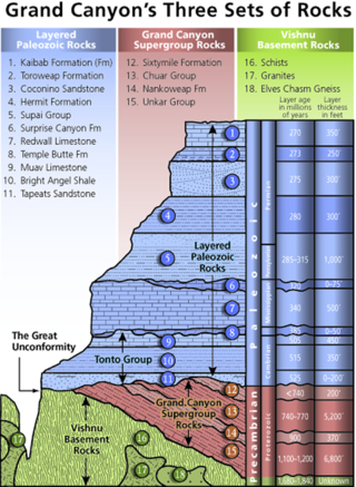
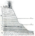
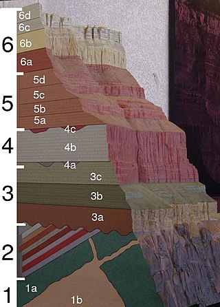
A stratigraphic column is a representation used in geology and its subfield of stratigraphy to describe the vertical location of rock units in a particular area. A typical stratigraphic column shows a sequence of sedimentary rocks, with the oldest rocks on the bottom and the youngest on top.
A stratotype or type section in geology is the physical location or outcrop of a particular reference exposure of a stratigraphic sequence or stratigraphic boundary. If the stratigraphic unit is layered, it is called a stratotype, whereas the standard of reference for unlayered rocks is the type locality.
Provenance in geology, is the reconstruction of the origin of sediments. The Earth is a dynamic planet, and all rocks are subject to transition between the three main rock types: sedimentary, metamorphic, and igneous rocks. Rocks exposed to the surface are sooner or later broken down into sediments. Sediments are expected to be able to provide evidence of the erosional history of their parent source rocks. The purpose of provenance study is to restore the tectonic, paleo-geographic and paleo-climatic history.
Geological perspective correlation is a theory in geology describing geometrical regularities in the layering of sediments. Seventy percent of the Earth's surface are occupied by sedimentary basins – volumes consisted of sediments accumulated during million years, and alternated by long interruptions in sedimentation (hiatuses). The most noticeable feature of the rocks, which filled the basins, is layering (stratification). Stratigraphy is a part of Geology that investigates the phenomenon of layering. It describes the sequence of layers in the basin as consisted of stratigraphic units. Units are defined on the basis of their lithology and have no clear definition. Geological Perspective Correlation (GPC) is a theory that divided the geological cross-section in units according strong mathematical rule: all borders of layers in this unit obey the law of perspective geometry.
Sedimentation layers are mainly created in shallow waters of oceans, seas, and lakes. As new layers are deposited the old ones are sinking deeper due to the weight of accumulating sediments. The content of sedimentary layers, their order in the sequence, and geometrical characteristics keep records of the history of the Earth, of past climate, sea-level and environment. Most knowledge about the sedimentary basins came from exploration drilling when searching for oil and gas. The essential feature of this information is that each layer is penetrated by the wells in a number of scattered locations. This raises the problem of identifying each layer in all wells – the geological correlation problem The identification is based on comparison of 1) physical and mineralogical characteristics of the particular layer (lithostratigraphy), or 2) petrified remnants in this layer (biostratigraphy). The similarity of layers is decreasing as the distance between the cross-sections increases that leads to ambiguity of the correlation scheme that indicates which layers penetrated at different locations belong to the same body. To improve the results geologists take in consideration the spatial relations between layers, which restricted the number of acceptable correlations. The first restriction was formulated in XVII century: the sequence of layers is the same in any cross-section. The second one was discovered by Haites in 1963: In an undisturbed sequence of layers (strata) the thicknesses of any layer observed in two different locations obey the law of perspective geometry, i.e. the perspective ratio K = H1/H2 is the same for all layers in this succession. This theory attracted attention around the world., and particularly in Russia The theory is also a basis of the method of graphical correlation in biostratigraphy widely used in oil and coal industries.

The Junggar Basin is one of the largest sedimentary basins in Northwest China. It is located in Xinjiang, and enclosed by the Tarbagatai Mountains of Kazakhstan in the northwest, the Altai Mountains of Mongolia in the northeast, and the Heavenly Mountains in the south. The geology of Junggar Basin mainly consists of sedimentary rocks underlain by igneous and metamorphic basement rocks. The basement of the basin was largely formed during the development of the Pangea supercontinent during complex tectonic events from Precambrian to late Paleozoic time. The basin developed as a series of foreland basins – in other words, basins developing immediately in front of growing mountain ranges – from Permian time to the Quaternary period. The basin's preserved sedimentary records show that the climate during the Mesozoic era was marked by a transition from humid to arid conditions as monsoonal climatic effects waned. The Junggar basin is rich in geological resources due to effects of volcanism and sedimentary deposition. According to Guinness World Records it is a land location remotest from open sea with great-circle distance of 2,648 km from the nearest open sea at 46°16′8″N86°40′2″E.