
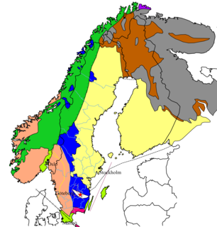
Halland is one of the traditional provinces of Sweden (landskap), on the western coast of Sweden. It borders Västergötland, Småland, Scania and the sea of Kattegat. Until 1645 and the Second Treaty of Brömsebro, it was part of the Kingdom of Denmark. Its name means Land of Rocky Slabs referring to the coastal cliffs of the region.

In geomorphology and geology, a peneplain is a low-relief plain formed by protracted erosion. This is the definition in the broadest of terms, albeit with frequency the usage of peneplain is meant to imply the representation of a near-final stage of fluvial erosion during times of extended tectonic stability. Peneplains are sometimes associated with the cycle of erosion theory of William Morris Davis, but Davis and other workers have also used the term in a purely descriptive manner without any theory or particular genesis attached.

Bohuslän is a Swedish province in Götaland, on the northernmost part of the country's west coast. It is bordered by Dalsland to the northeast, Västergötland to the southeast, the Skagerrak arm of the North Sea to the west, and the county of Østfold, in Norway, to the north. In English it literally means Bohus County, although it shared counties with the city of Gothenburg prior to the 1998 county merger and thus was not an administrative unit in its own right.
The Baltic Shield is a segment of the Earth's crust belonging to the East European Craton, representing a large part of Fennoscandia, northwestern Russia and the northern Baltic Sea. It is composed mostly of Archean and Proterozoic gneisses and greenstone which have undergone numerous deformations through tectonic activity. It contains the oldest rocks of the European continent with a thickness of 250-300 km.

In geology and geomorphology a base level is the lower limit for an erosion process. The modern term was introduced by John Wesley Powell in 1875. The term was subsequently appropriated by William Morris Davis who used it in his cycle of erosion theory. The "ultimate base level" is the plane that results from projection of the sea level under landmasses. It is to this base level that topography tends to approach due to erosion, eventually forming a peneplain close to the end of a cycle of erosion.

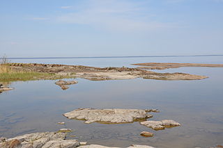
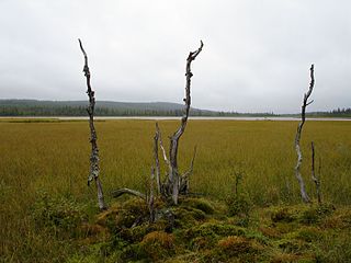
The High Coast is a part of the coast of Sweden on the Gulf of Bothnia, in the Ångermanland province of northeast Sweden, centered in the area of the municipalities of Kramfors, Härnösand, and Örnsköldsvik. It is notable as an area for research on post-glacial rebound and eustacy, in which the land rises as the covering glaciers melt, a phenomenon first recognised and studied there. Since the last ice age, the land has risen 300 meters, which accounts for the region's unusually tall cliffs. The High Coast is part of the Swedish/Finnish High Coast/Kvarken Archipelago World Heritage Site.

In glaciology, a roche moutonnée is a rock formation created by the passing of a glacier. The passage of glacial ice over underlying bedrock often results in asymmetric erosional forms as a result of abrasion on the "stoss" (upstream) side of the rock and plucking on the "lee" (downstream) side. These erosional features are seen on scales of less than a metre to several hundred metres.
In geology, epeirogenic movement is upheavals or depressions of land exhibiting long wavelengths and little folding apart from broad undulations. The broad central parts of continents are called cratons, and are subject to epeirogeny. The movement may be one of subsidence toward, or of uplift from, the centre of the Earth. The movement is caused by a set of forces acting along an Earth radius, such as those contributing to isostasy and faulting in the lithosphere.

Småland is a historical province (landskap) in southern Sweden. Småland borders Blekinge, Scania, Halland, Västergötland, Östergötland and the island Öland in the Baltic Sea. The name Småland literally means Small Lands. The Latinized form Smolandia has been used in other languages. The highest point in Småland is Tomtabacken, at 377 metres (1,237 ft). In terms of total area, Småland is of a similar size as Belgium.
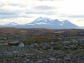
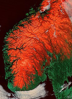
The Scandinavian Mountains or the Scandes is a mountain range that runs through the Scandinavian Peninsula. The western sides of the mountains drop precipitously into the North Sea and Norwegian Sea, forming the fjords of Norway, whereas to the northeast they gradually curve towards Finland. To the north they form the border between Norway and Sweden, reaching 2,000 metres (6,600 ft) high at the Arctic Circle. The mountain range just touches northwesternmost Finland but are scarcely more than hills at their northernmost extension at the North Cape.
The sub-Cambrian peneplain is an ancient, extremely flat, erosion surface (peneplain) that has been exhumed and exposed by erosion from under Cambrian strata over large swathes of Fennoscandia. Eastward, where this peneplain dips below Cambrian and other Lower Paleozoic cover rocks. The exposed parts of this peneplain are extraordinarily flat with relief of less than 20 m. The overlying cover rocks demonstrate that the peneplain was flooded by shallow seas during the Early Paleozoic. Being the oldest identifiable peneplain in its area the Sub-Cambrian peneplain qualifies as a primary peneplain.

Norrland terrain is a geomorphic unit covering the bulk of Norrland and the northwestern half of Svealand. Except for The High Coast the coastal areas of Norrland do not belong to the Norrland terrain. The southern and eastern boundary of the Norrland terrain is made up of geological faults that disrupt the Sub-Cambrian peneplain found the lowlands. In some locations these faults have been extensively eroded making the Norrland terrain boundary partly a result of erosion. Karna Lidmar-Bergström categorizes the Norrland Terrain into the following classes:
- Highlands with well developed valleys above 500 m.a.s.l.
- Plains with residual hills of Northern Sweden
- Undulating hilly land of Övertorneå/Överkalix
- Undulating hilly land of Boden area
- Large scale joint valley landscapes
- Plains with residual hills of Dalarna
- Undulating hilly land of Central Sweden

The South Swedish highlands or South Swedish Uplands are a hilly area covering large parts of Götaland in southern Sweden. Except for a lack of deep valleys, the landscape is similar to the Norrland terrain found further north in Sweden. The central-eastern parts of the highlands contain about thirty narrow canyons locally known as skurus.

The South Småland peneplain is a large flattish erosion surface, a peneplain, formed during the Tertiary, covering large swathes of southern Småland and nearby areas in Southern Sweden. To the east the South Småland peneplain bounds with the Sub-Cambrian peneplain uphill across an escarpment. While is almost as flat as the Sub-Cambrian peneplain the South Småland peneplain differs in that it contain far more residual hills and that it has never been covered by sedimentary rocks. To the south and west the peneplain transitions into Mesozoic-aged hilly surfaces.
The paleic surface or palaeic surface is an erosion surface of gentle slopes that exist in South Norway. Parts of it are a continuation of the Sub-Cambrian peneplain and Muddus Plains found further east or equivalent to the strandflat coastal plains of Norway. Hardangervidda, a particularly flat and elevated part of the Paleic surface formed in the Miocene at sea level.
Stöttingfjället is a highland in Swedish Lapland. Geologically, the southeastern portion of Stöttingsfjället is interpreted as being a part of the Sub-Cambrian peneplain that have been uplifted by faults.
Hügelland is a type of landscape consisting of low, rolling hills whose topography or surface structure lies between that of a lowland region and that of a more rugged hill range or low mountain range. The term is German and has no exact equivalent in English, but is often translated as "hill country", "hilly terrain", "upland(s)" or "gently undulating" or "rolling country", or "rolling countryside". It is derived from Hügel, a low hill or hillock and appears frequently as a proper name for this type of terrain.
In geology and geomorphology a paleosurface is a surface made by erosion of considerable antiquity. Paleosurfaces might be flat or uneven in some cases having considerable relief. Flat and large paleosurfaces —that is planation surfaces— have higher potential to be preserved than small and irregular surfaces and are thus the most studied kind of paleosurfaces. Irregular paleosurfaces, albeit usually smaller than flat ones, occur across the globe, one example being the Sudetes etchsurfaces. In the case of peneplains it is argued that they become paleosurfaces once they are detached from the base level they grade to.
A piedmonttreppen or piedmont benchland is a conceived landform consisting in a succession of benches at different heights and that forms in sequence during the uplift of a geological dome. The concept was first proposed in a posthumous publication by Walther Penck in 1924.

Joint valley landscape or fissure valley terrain is a type of relief common in Fennoscandia. The landscape originates from the erosion of joints in the bedrock which leaves out small plateaus or ridges in between. When the block summits in joint valley landscape are of different height it may indicate the past movement of a vertical geological fault.

