
A county is a geographical region of a country used for administrative or other purposes in certain modern nations. The term is derived from the Old French comté denoting a jurisdiction under the sovereignty of a count (earl) or a viscount. Literal equivalents in other languages, derived from the equivalent of "count", are now seldom used officially, including comté, contea, contado, comtat, condado, Grafschaft, graafschap, and zhupa in Slavic languages; terms equivalent to English language administrative terms such as municipality, district, circuit and commune/community are now often instead used.

Local government is a generic term for the lowest tiers of public administration within a particular sovereign state. This particular usage of the word government refers specifically to a level of administration that is both geographically-localised and has limited powers. While in some countries, "government" is normally reserved purely for a national administration (government), the term local government is always used specifically in contrast to national government – as well as, in many cases, the activities of sub-national, first-level administrative divisions. Local governments generally act only within powers specifically delegated to them by law and/or directives of a higher level of government. In federal states, local government generally comprises a third or fourth tier of government, whereas in unitary states, local government usually occupies the second or third tier of government.

A district is a type of administrative division that, in some countries, is managed by the local government. Across the world, areas known as "districts" vary greatly in size, spanning regions or counties, several municipalities, subdivisions of municipalities, school district, or political district.

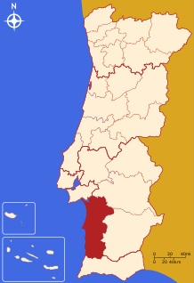
The District of Setúbal is a district located in the south-west of Portugal. It is named for its capital, the city of Setúbal.

The municipality is the second-level administrative subdivision of Portugal, as defined by the 1976 Constitution.

Administratively, Portugal is de jure unitary and decentralized state. Nonetheless, operationally, it is a highly centralized system with administrative divisions organized into three tiers. The State is organized under the principles of subsidiarity, local government autonomy, and democratic decentralization of the public service.

Freguesia, usually translated as "parish" or "civil parish", is the third-level administrative subdivision of Portugal, as defined by the 1976 Constitution. It is also the designation for local government jurisdictions in the former Portuguese overseas territories of Cape Verde and Macau. In the past, was also an administrative division of the other Portuguese overseas territories. The parroquia in the Spanish autonomous communities of Galicia and Asturias is similar to a freguesia.

Lisboa e Vale do Tejo was one of the five regions of Portugal. Today two of the subregions are in the new Lisboa Region, two in the Centro Region and one in the Alentejo Region.

The Lisbon Metropolitan Area is a metropolitan area in Portugal centered on Lisbon, the capital and largest city of the country. The metropolitan area, covering 18 municipalities is the largest urban area in the country and the 10th largest in the European Union, with a population in 2015 of 2,812,678 in an area of 3,015.24 km².

The administrative divisions of Ukraine are subnational administrative divisions within the geographical areas of Ukraine under the jurisdiction of the Ukrainian Constitution. The first level of subdivision consists of 27 regions:
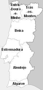
Beira was one of the six traditional provinces or comarcas of Portugal.

The Comunidade Intermunicipal da Lezíria do Tejo is an administrative division in Portugal. It was established as an Associação de Municípios in 1987, converted into a Comunidade Urbana in 2003, and converted into a Comunidade Intermunicipal in November 2008. It is also a NUTS3 subregion of the Alentejo Region. The seat of the intermunicipal community is the city of Santarém. Lezíria do Tejo comprises municipalities of the former districts of Santarém and Lisbon. The population in 2011 was 247,453, in an area of 4,275 square kilometres (1,651 sq mi). In the past, the territory of this administrative division was roughly entirely set in the former historical province of Ribatejo and had nothing to do with the former historical province of Alentejo. Lezíria is the Portuguese word for floodplain or freshwater marsh. Tejo is the name of the main river in the region. The Lezíria is a well-renowned center of intensive farming, horse breeding and animal husbandry.
The Comunidade Intermunicipal do Alentejo Litoral is an administrative division in Portugal. It was created in May 2009. It is also a NUTS3 subregion of the Alentejo Region. The seat of the intermunicipal community is Grândola. Alentejo Litoral comprises municipalities of both the Beja District and the Setúbal District. The population in 2011 was 97,925, in an area of 5,309.41 km2.
The Comunidade Intermunicipal do Alto Alentejo is an administrative division in Portugal. It was created in 2009. The seat of the intermunicipal community is Portalegre. Alto Alentejo is coterminous with the former Portalegre District. The population in 2011 was 118,506, in an area of 6,084.34 km². Together with Alentejo Central it covers the area of the former Alto Alentejo Province. With Ponte de Sor the intermunicipal community also includes one municipality that lies in the area of the former Ribatejo Province.
The Comunidade Intermunicipal do Baixo Alentejo is an administrative division in Portugal. It was created in 2009. It is also a NUTS3 subregion of the Alentejo Region. The seat of the intermunicipal community is Beja. Baixo Alentejo comprises 13 of the 14 municipalities of the Beja District. The population in 2011 was 126,692, in an area of 8,542.72 km².

The Nomenclature of Territorial Units for Statistics (NUTS) is developed by Eurostat, and employed in Portugal for statistical purposes. The NUTS branch extends from NUTS1, NUTS2 and NUTS3 regions, with the complementary LAU sub-categorization being used to differentiate the local areas, of trans-national importance.

The term "provinces" has been used throughout history to identify regions of continental Portugal. Current legal subdivisions of Portugal do not coincide with the provinces, but several provinces, in their 19th- and 20th-century versions, still correspond to culturally relevant, strongly self-identifying categories. They include:

The intermunicipal community is a type of administrative division in Portugal. Since the 2013 local government reform, there are 21 intermunicipal communities. They replaced the urban communities, the intermunicipal communities for general purposes and some metropolitan areas that were created in 2003, and abolished in 2008. The territories of the intermunicipal communities are the basis of the NUTS III statistical regions.

