Regions
In 1922 under the British Tanganyika was divided into twenty-two regions, known as "divisions": Arusha, Bagamoyo, Bukoba, Dar es Salaam, Dodoma, Iringa, Kilwa, Kondoa-Irangi, Lindi, Mahenge, Morogoro, Moshi, Mwanza, Pangani, Rufiji, Rungwe, Songea, Tabora, Tanga, Ufipa, Ujiji, and Usambara.

Tanzania, officially the United Republic of Tanzania, is a country in East Africa within the African Great Lakes region. It is bordered by Uganda to the north; Kenya to the northeast; the Indian Ocean to the east; Mozambique and Malawi to the south; Zambia to the southwest; and Rwanda, Burundi, and the Democratic Republic of the Congo to the west. Mount Kilimanjaro, Africa's highest mountain, is in northeastern Tanzania. According to the 2022 national census, Tanzania has a population of nearly 62 million, making it the most populous country located entirely south of the equator.
The politics of Tanzania takes place in a framework of a unitary presidential democratic republic, whereby the President of Tanzania is both head of state and head of government, and of a multi-party system. Executive power is exercised by the government. Legislative power is vested in both the government and parliament. The party system is dominated by the Chama Cha Mapinduzi. The Judiciary is independent of the executive and the legislature.
A county is a geographic region of a country used for administrative or other purposes in some nations. The term is derived from the Old French comté denoting a jurisdiction under the sovereignty of a count (earl) or a viscount. Literal equivalents in other languages, derived from the equivalent of "count", are now seldom used officially, including comté, contea, contado, comtat, condado, Grafschaft, graafschap, and zhupa in Slavic languages; terms equivalent to 'commune' or 'community' are now often instead used.

Local government is a generic term for the lowest tiers of governance or public administration within a particular sovereign state.
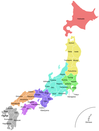
Japan is divided into 47 prefectures, which rank immediately below the national government and form the country's first level of jurisdiction and administrative division. They include 43 prefectures proper, two urban prefectures, one regional prefecture and one metropolis. In 1868, the Meiji Fuhanken sanchisei administration created the first prefectures to replace the urban and rural administrators in the parts of the country previously controlled directly by the shogunate and a few territories of rebels/shogunate loyalists who had not submitted to the new government such as Aizu/Wakamatsu. In 1871, all remaining feudal domains (han) were also transformed into prefectures, so that prefectures subdivided the whole country. In several waves of territorial consolidation, today's 47 prefectures were formed by the turn of the century. In many instances, these are contiguous with the ancient ritsuryō provinces of Japan.

A district is a type of administrative division that in some countries is managed by the local government. Across the world, areas known as "districts" vary greatly in size, spanning regions or counties, several municipalities, subdivisions of municipalities, school district, or political district.

Myanmar is divided into 21 administrative divisions, which include seven regions, seven states, one union territory, one self-administered division, and five self-administered zones.

Fiji is divided administratively into four divisions, which are further subdivided into fourteen provinces. Each province has a provincial council.

The bureaucratic administration of Japan is divided into three basic levels: national, prefectural, and municipal. They are defined by the Local Autonomy Law of 1947.
Pangani District Council is one of eleven administrative districts of Tanga Region in Tanzania. The District covers an area of 1,756 km2 (678 sq mi). It is bordered to the north by Muheza District, to the east by Zanzibar Channel, to the south by the Chalinze District of Pwani Region, and to the west by the Handeni District. The district is comparable in size to the land area of Guadeloupe. The district seat (capital) and largest settlement in Pangani district is the town of Pangani. The district is named after the historic Pangani River. As of the 2022 census, the population was Pangani district was 75,642, making it the least populous district in Tanga Region.

Babati Rural District is a district of Manyara Region of Tanzania, East Africa. The administrative capital of the district is Babati town, 172 km (107 mi) south of Arusha. The district covers an area of 6,069 km2 (2,343 sq mi), a large proportion (640 km2) of which is covered by the water bodies of Lake Babati, Lake Burunge and Lake Manyara. The district is bordered to the north by Arusha Region, to the south east by Simanjiro District, to the south by Dodoma Region, to the south west by Hanang District, and to the north west by Mbulu District. Babati Urban District is located within the district.
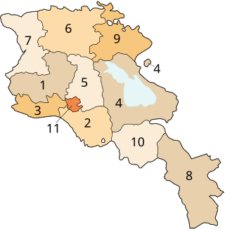
Armenia is subdivided into eleven administrative divisions. Of these, ten are provinces, known as marzer (մարզեր) or in the singular form marz (մարզ) in Armenian.
A ward is a local authority area, typically used for electoral purposes. In some countries, wards are usually named after neighbourhoods, thoroughfares, parishes, landmarks, geographical features and in some cases historical figures connected to the area. It is common in the United States for wards to simply be numbered.

The administrative divisions of Nepal are subnational administrative units of Nepal. The first level of country subdivision of Nepal are the provinces. Each province is further subdivided into districts, each district into municipalities and rural municipalities, and each of those municipalities into wards. Before 2015, instead of provinces, Nepal was divided into developmental regions and administrative zones.
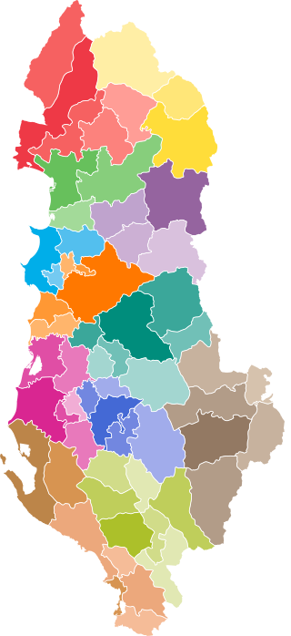
The administrative divisions of Albania comprise 12 counties, 61 municipalities, 373 administrative units, and 2,972 villages. Since its 1912 Declaration of Independence, Albania has reorganized its domestic administrative divisions 21 times. Its internal boundaries have been enlarged or subdivided into prefectures, counties, districts, subprefectures, municipalities, communes, neighborhoods or wards, villages, and localities. The most recent changes were made in 2014 and enacted in 2015.
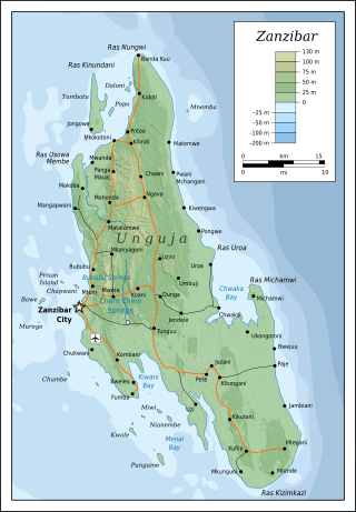
Unguja is the largest and most populated island of the Zanzibar archipelago, in Tanzania.
The subdivisions of Kenya have been in place since 2010, replacing the old system. Under the Constitution of 2010 and other reforms to Provincial Administration the country acquired a new system of Counties. The previous Provinces were scrapped and the 46 Districts, in existence since 1992, were turned into Counties with elected governments.
The following outline is provided as an overview of and topical guide to Tanzania:
Vietnam is divided into 63 provinces and cities, with 5 cities and 58 provinces. It is a unitary state, so there is no such thing as a state or self-governing provinces.

Sokon II is one of the 27 administrative wards of the Arusha District Council located in the Arusha Region of Tanzania. The name Sokon comes from the Swahili word for market, sokoni. The ward shares a similar name with another ward located in Arusha Urban District called Sokon I and the former is one of 27 rural administrative wards in the district as of 2012. Sokon II ward is bordered by Oltoroto and Moivo ward in the west, Ilkiding'a ward to the north, Bangata ward to the east. On the southern border Sokon II is bordered by Baraa, Kimandolu and Sekei wards. According to the 2012 census, the ward has a total population of 32,073. Thus, Sokon II is the most populous ward in Arusha District. Also the ward headquarters are Oldadai village. In addition, the Arusha District Administration building is located in Sokon II ward.
