Suffern, New York

Last updated

Suffern, New York
Suffern NY Downtown.JPG
Downtown Suffern
Suffern, New York Seal.png
Rockland County New York incorporated and unincorporated areas Suffern highlighted.svg
Location in Rockland County and the state of New York
USA New York location map.svg
Red pog.svg
Suffern, New York
Location within the state of New York
Coordinates: 41°6′43″N74°8′45″W / 41.11194°N 74.14583°W / 41.11194; -74.14583
CountryFlag of the United States.svg  United States
State Flag of New York.svg  New York
County Rockland
Settled1773
Incorporated 1796
Government
  MayorMichael Curley
  Deputy MayorJo Meegan-Corrigan
  TrusteesSteven Alpert, Angela Denis-Hogue, and Clarke Osborn.
Area
[1]
  Total2.13 sq mi (5.52 km2)
  Land2.10 sq mi (5.43 km2)
  Water0.03 sq mi (0.08 km2)
Elevation
312 ft (95 m)
Population
 (2021)
  Total11,402
  Density5,455.89/sq mi (2,106.45/km2)
Time zone UTC-5 (Eastern (EST))
  Summer (DST) UTC-4 (EDT)
ZIP Code
10901
Area code 845
FIPS code 36-71894
GNIS feature ID2391161
Website www.suffernny.gov

Suffern is a village that was incorporated in 1796 in the town of Ramapo in Rockland County, New York. Sitting adjacent to the town of Mahwah, New Jersey, Suffern is located 31 miles northwest of Manhattan. [2] As of the 2020 census, Suffern's population was 11,402. [3]

Contents

History

The village of Suffern viewed from the top of Nordkop Mountain Suffern NY.jpg
The village of Suffern viewed from the top of Nordkop Mountain

"The Point of the Mountains" or "Sidman's Clove" were names used before the American Revolution to designate the present village of Suffern. The area originally was inhabited by the Ramapough, a tribe of Munsee, who were a division of the Lenape tribe. Upon Sidman's death, this land passed into the hands of his son-in-law, John Smith, who sold it to John Suffern.

The village of Suffern was founded in 1796. John Suffern, first Rockland County judge, 1798–1806, settled near the base of the Ramapo Mountains in 1773, and called the place New Antrim, after his home in County Antrim, Northern Ireland. His French Huguenot ancestors had settled there after fleeing religious persecution in France. New Antrim's location was considered strategically important in the Revolutionary War because it was at an important crossroads near Ramapo Pass. General George Washington and other important military leaders used John Suffern's home as headquarters when they were in the area.

This history has been recognized by the town. Suffern is a stop on the Washington–Rochambeau Revolutionary Route National Historic Trail, under the auspices of the National Park Service. [4] [ failed verification see discussion ] [5] [ failed verification ] This trail commemorates the route followed by General Washington and the French Comte de Rochambeau as they traveled to the siege of Yorktown, Virginia, which led to victory for the United States in gaining independence.

Rochambeau made encampment with his 5,000 soldiers in Suffern on August 25, 1781, on his way to Yorktown, and again on September 13, 1782, as he retraced his steps to New York. [6] An historical marker on the Washington Avenue side of the Lafayette Theatre identifies this site of "Rochambeau's Encampment 1781–1782". The National Park Service has installed a wayside panel near the gazebo in Suffern to commemorate Rochambeau's encampment in Suffern. At the time of the encampment, this site was directly across the road from village founder John Suffern's home and tavern where the Count de Rochambeau stayed. [6] Based on an 1860 painting of John Suffern's home that showed the well in the side yard, his home would have been in at the area of Licata Insurance. The well is in the basement of the furniture store.

During the war, Commander-in-Chief General Washington and his regiment made camp in the village several times. Lafayette Avenue, the main street of Suffern, is named in honor of Revolutionary War hero Marie-Joseph Paul Yves Roch Gilbert du Motier, better known as the Marquis de Lafayette.

Other guests who took advantage of Suffern's hospitality included Lieutenant Colonel Aaron Burr, who later became the third Vice President of the United States; General George Clinton, who became the first (and longest-serving) elected Governor of New York, as well as the fourth Vice President of the United States (under both Thomas Jefferson and James Madison); and Alexander Hamilton, first United States Secretary of the Treasury under President Washington.

From Suffern to Monroe was a main route of travel through the western Hudson Highlands. The main road was the Albany Post Road, one of the oldest roads in the state, which served as the stagecoach line between Albany and New York City . Once the Hudson River froze in winter, the Post Road was heavily traveled as an alternate. The 20 miles (32 km) of road through Ramapo Pass was later developed as the Orange Turnpike (now known as Route 17). Tolls were collected from 1800 until 1886 to maintain and improve the road. The New York State Thruway now runs through the pass. The south entrance to the town was garrisoned during the Revolution, with General Washington ordering as many as 400 soldiers to be stationed there at all times.

The first railroad line across Rockland County, the Erie Railroad, was built in 1841 and ran from Piermont to Ramapo. By 1851, the line was extended to Lake Erie, and was considered an engineering marvel. The tracks are now owned by the Norfolk Southern line. In consideration for the right-of-way given it by Judge Edward Suffern, son of founder John, to lay track across his 6 miles (10 km) of land, the Erie Railroad named their depot "Suffern's Station." The village became known as Suffern, not New Antrim, as it had been called by John Suffern.

In 1897, Avon Products, known then as California Perfume Company, built a 3,000-square-foot (280 m2) laboratory in Suffern. By 1971 the lab had been expanded into the 323,000-square-foot (30,000 m2) Avon Suffern Research and Development facility. In late 2005, construction was finished on a state-of-the art, 225,000-square-foot (20,900 m2) facility that would become Avon's global hub for research and development. The new building was constructed on the same site as their previous R&D facility, which was demolished for site parking.

In 2023, Avon sold to Regeneron Pharmaceuticals to be used for Research & Development Laboratories [7]

In 1916, what would become New York State Route 59, which reached from Nyack to Spring Valley in 1915, was extended to Suffern and Ramapo Hamlet.

In 1924, the Lafayette Theatre, named for the Revolutionary War hero the Marquis de Lafayette, opened its doors.

In 1972, the Salvation Army moved their School for Officer Training to a 30-acre (120,000 m2) site in Suffern. They took over the former School of the Holy Child, a Catholic school for girls. [8]

Geography

According to the United States Census Bureau, the village has a total area of 2.1 square miles (5.4 km2), of which 0.04 square miles (0.10 km2), or 1.42%, is water.

Suffern is designated as a gateway to the Hudson River Valley National Heritage Area. [9]

Demographics

Historical population
CensusPop.Note
1900 1,619
1910 2,66364.5%
1920 3,15418.4%
1930 3,75719.1%
1940 3,7680.3%
1950 4,0106.4%
1960 5,09427.0%
1970 8,27362.4%
1980 10,79430.5%
1990 11,0552.4%
2000 11,006−0.4%
2010 10,723−2.6%
2020 11,4416.7%

As of the census [15] of 2000, there were 11,006 people, 4,634 households, and 2,836 families residing in the village. The population density was 5,265.8 inhabitants per square mile (2,033.1/km2). There were 4,762 housing units at an average density of 2,278.4 per square mile (879.7/km2). The racial makeup of the village was 86.83% white, 3.53% African American, 0.26% Native American, 2.83% Asian, 0.09% Pacific Islander, 4.52% from other races, and 1.94% from two or more races. Hispanic or Latino of any race were 12.87% of the population.

There were 4,634 households, out of which 25.2% had children under the age of 18 living with them, 47.6% were married couples living together, 10.2% had a female householder with no husband present, and 38.8% were non-families. 32.5% of all households were made up of individuals, and 12.2% had someone living alone who was 65 years of age or older. The average household size was 2.36 and the average family size was 3.00.

In the village, the population was spread out, with 20.1% under the age of 18, 7.4% from 18 to 24, 32.9% from 25 to 44, 24.7% from 45 to 64, and 14.9% who were 65 years of age or older. The median age was 39 years. For every 100 females, there were 92.1 males. For every 100 females age 18 and over, there were 89.7 males.

The median income for a household in the village was $59,754, and the median income for a family was $74,937. Males had a median income of $46,959 versus $36,093 for females. The per capita income for the village was $29,208. About 3.5% of families and 5.7% of the population were below the poverty line, including 7.6% of those under age 18 and 6.4% of those age 65 or over.

Economy

Novartis had a manufacturing facility in Suffern, employing approximately 525 workers. [16] In January 2014, the company announced closure of this facility by 2017, citing loss of patent exclusivity on Diovan as a major factor in the decision. [16] [17] :54 The facility was engaged in the "production of tablets, capsules, vials and inhalation products". [17] :99

Avon's Global Research and Development facility is located in Suffern, employing 350 scientists and technicians in developing cosmetics. [18]

Arts and culture

Suffern Piermont Branch Station Suffern REA Station.jpg
Suffern Piermont Branch Station
Soldier's Monument at Washington and Lafayette avenues Washington Avenue Soldiers' Monument.jpg
Soldier's Monument at Washington and Lafayette avenues
Lafayette Theater exterior Lafayette Theater Suffern NY.JPG
Lafayette Theater exterior
Post office Suffern, NY, post office.jpg
Post office

Historical markers

Landmarks and places of interest

Government

Suffern's government is headed by a mayor, Michael Curley. The mayor presides over a village board consisting of four trustees. The village is represented in the United States House of Representatives by Mike Lawler. In state government, it is represented by Senator Bill Weber and Assemblyman Karl Brabenec. Suffern is an incorporated village within the town of Ramapo, with Michael Specht serving as town supervisor.

Education

Suffern Middle School is the junior high school of the Suffern Central School District (SCSD), [20] and is located in the village Montebello, adjacent to Suffern. [21] The 1,200 grade 6-8 students educated there hail from Airmont, Suffern, Montebello, Hillburn, Sloatsburg and parts of Monsey.

The village is home to Richard P. Connor Elementary School, also part of SCSD. Viola Elementary School is located in the neighboring CDP of Viola. High school students are zoned to Suffern High School.

In 2013, Cherry Lane Elementary School, located in the neighboring Village of Airmont and part of SCSD, became one of the Blue Ribbon School of Excellence Award winners awarded by the U.S. Department of Education. [22]

Rockland Community College, part of the SUNY system, is located just outside the village limits.

Media

Infrastructure

Transportation

Suffern station Suffern train station 2010.jpg
Suffern station

Suffern station serves both local and express trains, operated by New Jersey Transit to Hoboken Terminal with connecting service at Secaucus Junction to New York's Pennsylvania Station. Most New Jersey Transit Main Line trains terminate at Suffern; some Bergen County Line trains also terminate at Suffern; and Metro-North Railroad's Port Jervis Line trains continue into Orange County to Port Jervis. Transport of Rockland buses serve Suffern, as well as Hudson Link buses, and the Bergen County routes of Coach USA ShortLine.

U.S. Route 202, New York State Route 59, Interstate 287, and Interstate 87, also known as the New York State Thruway, go through Suffern.

Notable people

Related Research Articles

<span class="mw-page-title-main">Rockland County, New York</span> County in New York, United States

Rockland County is the second-southernmost county on the west side of the Hudson River in the U.S. state of New York, after Richmond County. It is part of the New York metropolitan area. As of the 2020 U.S. census, the county's population is 338,329, making it the state's third-most densely populated county outside New York City after Nassau and neighboring Westchester Counties. The county seat and largest hamlet is New City. Rockland County is accessible via the New York State Thruway, which crosses the Hudson to Westchester at the Tappan Zee Bridge ten exits up from the NYC border, as well as the Palisades Parkway five exits up from the George Washington Bridge. The county's name derives from "rocky land", as the area has been aptly described, largely due to the Hudson River Palisades. The county is part of the Hudson Valley region of the state.

<span class="mw-page-title-main">Airmont, New York</span> Village in New York, United States

Airmont is a village in the town of Ramapo, Rockland County, New York, United States, located north of the state of New Jersey, east of Suffern, south of Montebello, and west of Chestnut Ridge. The population was 10,166 at the 2020 census.

<span class="mw-page-title-main">Hillburn, New York</span> Village in New York, United States

Hillburn, originally called "Woodburn" and incorporated in 1893, is a village in the town of Ramapo, Rockland County, New York, United States. It is located north of Suffern, east of Orange County, south of Viola, and west of Montebello. It is considered to be one of the more rural communities in Rockland County. The population was 930 at the 2020 census.

<span class="mw-page-title-main">Montebello, New York</span> Village in New York, United States

Montebello is an incorporated village in Ramapo, Rockland County, New York, United States. It is located north of Suffern, east of Hillburn, south of Wesley Hills, and west of Airmont. The population was 4,507 at the 2020 census.

<span class="mw-page-title-main">Piermont, New York</span> Village in New York, United States

Piermont is a village incorporated in 1847 in Rockland County, New York, United States. Piermont is in the town of Orangetown, located north of the hamlet of Palisades, east of Sparkill, and south of Grand View-on-Hudson, on the west bank of the Hudson River. The population was 2,517 at the 2020 census. Woody Allen set The Purple Rose of Cairo (1984) in Piermont.

<span class="mw-page-title-main">Ramapo, New York</span> Town in New York, United States

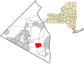
Ramapo is a town in Rockland County, New York, United States. It was originally formed as New Hampstead, in 1791, and became Ramapo in 1828. It shares its name with the Ramapo River. As of the 2020 census, Ramapo had a total population of 148,919, making it the most populous town in New York outside of Long Island. If all towns in New York were cities, Ramapo would be the 12th-largest city in the state of New York.

<span class="mw-page-title-main">Sloatsburg, New York</span> Village in Ramapo, New York, US

Sloatsburg is a village in the town of Ramapo in Rockland County, New York, United States. Located east of Orange County, it is at the southern entrance to Harriman State Park. The population was 3,036 at the 2020 census. The village is named after Stephen Sloat, an early European landowner.

<span class="mw-page-title-main">Spring Valley, New York</span> Village in Rockland County, New York, United States

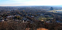
Spring Valley is a village in the town of Ramapo and Clarkstown in Rockland County, New York, United States. It is located north of Chestnut Ridge, east of Airmont and Monsey, south of Hillcrest, and west of Nanuet. The population was 33,066 at the 2020 census, making it the second most populous community in both Clarkstown and Rockland County, after New City.

<span class="mw-page-title-main">Tappan, New York</span> Census-designated place in New York, United States

Tappan is a hamlet and census-designated place in the town of Orangetown, Rockland County, New York. It is located northwest of Alpine, New Jersey, north of Northvale, New Jersey and Rockleigh, New Jersey, northeast of Old Tappan, New Jersey, east/southeast of Nauraushaun and Pearl River, south of Orangeburg, southwest of Sparkill, and west of Palisades; Tappan shares a border with each. The population was 6,673, according to the 2020 census.

<span class="mw-page-title-main">Viola, New York</span> Census-designated place in New York, United States

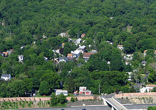
Viola is a hamlet and census-designated place in the town of Ramapo, Rockland County, New York, United States. It is located north of Airmont, east of Montebello, south of Wesley Hills, and west of Hillcrest. The population was 6,868 at the 2010 census.

<span class="mw-page-title-main">Wesley Hills, New York</span> Village in New York, United States

Wesley Hills is a village in the town of Ramapo, Rockland County, New York, United States. It is located north of Viola, east of Harriman State Park, south of Pomona, and west of New Hempstead. The population was 5,628 at the 2010 census.

<span class="mw-page-title-main">West Nyack, New York</span> Census-designated place in New York, United States

West Nyack is a hamlet and census-designated place in the town of Clarkstown, Rockland County, New York, United States. It is located north of Blauvelt, east of Nanuet, southwest of Valley Cottage, southeast of Bardonia, and west of Central Nyack. It is approximately 18 miles (29 km) north of New York City. The population was 3,439 at the 2010 census.

<span class="mw-page-title-main">Haverstraw, New York</span> Town in New York, United States

Haverstraw is a town in Rockland County, New York, United States, located north of the Town of Clarkstown and the Town of Ramapo; east of Orange County; south of the Town of Stony Point; and west of the Hudson River. The town runs from the west to the east border of the county in its northern section. The population was 39,087 at the 2020 census.

<span class="mw-page-title-main">New York State Route 59</span> State highway in Rockland County, New York, US

New York State Route 59 (NY 59) is an east–west state highway in southern Rockland County, New York, in the United States. The route extends for 14.08 miles (22.66 km) from NY 17 in Hillburn to U.S. Route 9W (US 9W) in Nyack. In Suffern, it has a concurrency with US 202 for 0.05 miles (0.08 km). NY 59 runs parallel to the New York State Thruway its entire route. The routing of NY 59 became a state highway in 1911 and was signed as NY 59 in the late 1920s.

<span class="mw-page-title-main">Suffern station</span> Metro-North Railroad station in New York

Suffern station is a railroad station in the village of Suffern. The station, located on Ramapo Avenue in Suffern, services trains of New Jersey Transit's Main Line and Metro-North Railroad's Port Jervis Line. Suffern station serves as the terminal for Main Line trains, as trains continue north into Hillburn Yard. The next Main Line station, located in New Jersey, is Mahwah. The next Port Jervis Line station to the north is Sloatsburg. The station consists of two low-level side platforms for trains in both directions, neither of which are handicap accessible for the Americans with Disabilities Act of 1990.

<span class="mw-page-title-main">Washington Avenue Soldier's Monument and Triangle</span> United States historic place

The Washington Avenue Soldier's Monument is located at the junction of that street and Lafayette Avenue in the village of Suffern, New York, United States. It sits on a small piece of land in the middle of the street known locally as the Triangle.

<span class="mw-page-title-main">Suffern Central School District</span> School district in Rockland County, New York, United States

Suffern Central School District, formerly the Ramapo Central School District, is a school district headquartered in Hillburn, a village in the Town of Ramapo in Rockland County, New York, United States located north of Suffern; east of Orange County, New York; south of Viola and west of Montebello.

Sterlington, was a tiny community located in the Town of Ramapo, Rockland County, New York, United States located between Suffern and Sloatsburg.

The recorded history of Rockland County, New York begins on February 23, 1798, when the county was split off from Orange County, New York and formed as its own administrative division of the state of New York. It is located 6 miles (9.7 km) north-northwest of New York City, and is part of the New York Metropolitan Area. The county seat is the hamlet of New City. The name comes from rocky land, an early description of the area given by settlers. Rockland is New York's southernmost county west of the Hudson River. It is suburban in nature, with a considerable amount of scenic designated parkland. Rockland County does not border any of the New York City boroughs, but is only 9.5 miles (15.3 km) north of Manhattan at the counties' two respective closest points

<span class="mw-page-title-main">Monroe, New York</span> Town in Orange County, New York, US

Monroe is a town in Orange County, New York, United States. The population was 21,387 at the 2020 census, compared to 39,912 at the 2010 census; the significant fall in census population was due to the secession of the town of Palm Tree in 2019. The town is named after President James Monroe.

References

  1. "ArcGIS REST Services Directory". United States Census Bureau. Retrieved September 20, 2022.
  2. "Distance between Suffern, NY 10901 and Manhattan, New York, NY 31 Miles - 49 Km".
  3. "2020 Census Redistricting Data: Suffern village; New York". data.census.gov. U.S. Census Bureau. Retrieved June 9, 2023.
  4. "Washington-Rochambeau National Historic Trail". National Park Service. Retrieved October 31, 2015.
  5. "Washington–Rochambeau Revolutionary Route". W3R-US. Retrieved October 31, 2015.
  6. 1 2 Suffern, Carolyn (September 23, 2010). "John Suffern, of Suffern, NY" (PDF). The Washington-Rochambeau Revolutionary Route Association, Inc. Archived from the original (PDF) on September 15, 2012. Retrieved October 31, 2015.
  7. Regeneron Pharmaceuticals Purchases Avon in Suffern For $38.875 Million, To be Used For Research & Development Laboratories
  8. "School of the Holy Child, Suffern, New York".
  9. http://www.hudsonrivervalley.com [ bare URL ]
  10. "Population (00171811ch01.pdf)" (PDF). United States Census Bureau. December 15, 1922. p. 70. Retrieved December 21, 2017.
  11. "New Hampshire - New York (10612982v3p2ch03.pdf)" (ZIP). United States Census Bureau. p. 296. Retrieved December 21, 2017.
  12. "Number of Inhabitants, New York (37749573v1p34ch2.pdf)" (ZIP). United States Census Bureau. p. 24. Retrieved December 21, 2017.
  13. "1990 Census of Population and Housing, Population and Housing Unit Counts, New York" (PDF). United States Census Bureau. September 29, 1992. p. 29. Retrieved December 21, 2017.
  14. "Profiles of General Demographic Characteristics, 2000 Census of Population and Housing, New York" (PDF). United States Census Bureau. May 2001. p. 1915. Retrieved December 21, 2017.
  15. "U.S. Census website". United States Census Bureau . Retrieved January 31, 2008.
  16. 1 2 "Novartis Shutting Down Suffern, NY, Plant". News: Bioprocessing. Gen. Eng. Biotechnol. News (paper). Vol. 34, no. 4. February 15, 2014. p. 24.
  17. 1 2 "FORM 20-F". EDGAR . U.S. Securities and Exchange Commission. January 29, 2014.
  18. "Leading Global Brands". Avon Products . Avon Products. July 28, 2014.
  19. Cacioppo, Nancy (November 3, 2002). "Boy Scout founder's estate become Brooklands Park". The Journal News. White Plains.
  20. "Suffern Central". Our Schools (dropdown menu). Retrieved December 21, 2017.
  21. "Map and Directions". Suffern Central School District. Retrieved December 21, 2017.
  22. "National Blue Ribbon Schools Program: Schools Recognized" (PDF). U.S. Department of Education. Retrieved October 31, 2015.
  23. Roberts, Karen. "De Niro movie 'The Irishman' filming in Suffern", The Journal News , September 21, 2017. Accessed March 19, 2019. "De Niro movie 'The Irishman' filming in Suffern"
  24. Suburbarazzi. "CBS series filming in Suffern Oct. 18", The Journal News , October 18, 2018. Accessed March 19, 2019. "CBS series filming in Suffern Oct. 18"
  25. Holden, Stephen. "Leaping Slowly From Theater to Cabaret", The New York Times , September 1, 1989. Accessed September 26, 2017. "'Instead of the Beatles and the Stones, I grew up listening to Ethel Merman and Mary Martin. And because I was only 30 miles away from the city, in Suffern, N.Y., it seemed natural that I go to New York City after high school.'"
  26. Robinson, Alex. "Boy Scout leader remembered with street co-naming" [ permanent dead link ], TimesLedger , June 30, 2014. Accessed September 26, 2017. "He was born in Kentucky and later moved to New York City, living in Flushing, where he founded the Sons of Daniel Boone, before he moved to Suffern, N.Y."
  27. Anderson, Dave. "Opinions From Some Umpires in Exile", The New York Times , April 8, 1979. Accessed September 26, 2017. "They were sitting around after dinner in Marty Springstead's home in Suffern, N.Y., between Yankee Stadium picketing assignments."
  28. Croke, Karen. "Grace VanderWaal won 'AGT' one year ago, Sept. 14, 2016", The Journal News , September 14, 2017. Accessed September 26, 2017. "One year ago tonight, Grace VanderWaal, a talented but then unknown middle school student from Suffern, won the biggest prize of her then young life: The $1 million grand prize on America's Got Talent."
  29. Armstrong, Kevin. "Colorado manager Walt Weiss, raised in Suffern, living the mile-high life with Rockies", New York Daily News , May 11, 2013. Accessed September 26, 2017. "Durability was always a point of pride for Weiss as baseball carried him to all four corners of the country. Born in Tuxedo, N.Y., and raised in neighboring Suffern, 35 miles north of Manhattan, he reported to the home dugout inside parks from Pocatello, Idaho, to Huntsville, Ala., to Tacoma, Wash., to Oakland, Miami and Atlanta."