Sullivan, Wisconsin | |
---|---|
Coordinates: 42°58′7″N88°36′32″W / 42.96861°N 88.60889°W | |
Country | United States |
State | Wisconsin |
County | Jefferson |
Government | |
• Type | Village Board |
• President | Terrisa Laurin |
Area | |
• Total | 1.14 sq mi (2.94 km2) |
• Land | 1.13 sq mi (2.93 km2) |
• Water | 0.00 sq mi (0.01 km2) |
Elevation | 863 ft (263 m) |
Population | |
• Total | 651 |
• Density | 586.94/sq mi (226.63/km2) |
Time zone | UTC-6 (Central (CST)) |
• Summer (DST) | UTC-5 (CDT) |
ZIP Code | 53178 |
Area code | 262 |
FIPS code | 55-78200 [4] |
GNIS feature ID | 1575043 [2] |
Website | http://www.villageofsullivan-gov.us/ |
Sullivan (formerly Winfield) is a village in Jefferson County, Wisconsin, United States. The population was 651 at the 2020 census. The village is located within the Town of Sullivan, and is known to residents of southern Wisconsin including the Madison and Milwaukee metro areas as the location of the National Weather Service forecast office MKX, although its mailing address is in nearby Dousman. [5]
A post office called Sullivan has been in operation since 1846. [6] The village took its name from the Town of Sullivan. [7]
Sullivan is located at 43°0′46″N88°35′15″W / 43.01278°N 88.58750°W (43.012791, -88.587515), [8] about 30 miles (48 km) west of Milwaukee and 40 miles (64 km) east of Madison, approximately 6 miles (10 km) south of Interstate 94. The center of the village is situated at the intersection of Main Street (Hwy 18 and Hwy F) and Palmyra Street (Hwy E).
According to the United States Census Bureau, the village has a total area of 1.14 square miles (2.95 km2), all land. [9]
Climate data for Sullivan 3SE, Wisconsin (MKX Weather Forecast Office) (1991–2020 normals, extremes 1995–present) | |||||||||||||
---|---|---|---|---|---|---|---|---|---|---|---|---|---|
Month | Jan | Feb | Mar | Apr | May | Jun | Jul | Aug | Sep | Oct | Nov | Dec | Year |
Record high °F (°C) | 60 (16) | 71 (22) | 85 (29) | 89 (32) | 95 (35) | 99 (37) | 106 (41) | 98 (37) | 96 (36) | 90 (32) | 75 (24) | 67 (19) | 106 (41) |
Mean maximum °F (°C) | 49.4 (9.7) | 52.7 (11.5) | 68.3 (20.2) | 80.3 (26.8) | 86.5 (30.3) | 91.6 (33.1) | 93.1 (33.9) | 91.5 (33.1) | 89.3 (31.8) | 81.3 (27.4) | 66.1 (18.9) | 52.2 (11.2) | 95.2 (35.1) |
Mean daily maximum °F (°C) | 26.9 (−2.8) | 31.0 (−0.6) | 43.2 (6.2) | 56.4 (13.6) | 68.5 (20.3) | 78.3 (25.7) | 82.1 (27.8) | 80.3 (26.8) | 73.3 (22.9) | 60.0 (15.6) | 45.0 (7.2) | 32.5 (0.3) | 56.5 (13.6) |
Daily mean °F (°C) | 19.1 (−7.2) | 22.6 (−5.2) | 33.5 (0.8) | 45.6 (7.6) | 57.3 (14.1) | 67.2 (19.6) | 71.1 (21.7) | 69.4 (20.8) | 62.0 (16.7) | 49.8 (9.9) | 36.5 (2.5) | 24.9 (−3.9) | 46.6 (8.1) |
Mean daily minimum °F (°C) | 11.3 (−11.5) | 14.1 (−9.9) | 23.9 (−4.5) | 34.7 (1.5) | 46.0 (7.8) | 56.1 (13.4) | 60.1 (15.6) | 58.6 (14.8) | 50.8 (10.4) | 39.5 (4.2) | 27.9 (−2.3) | 17.4 (−8.1) | 36.7 (2.6) |
Mean minimum °F (°C) | −10.4 (−23.6) | −5.3 (−20.7) | 3.7 (−15.7) | 21.8 (−5.7) | 32.3 (0.2) | 42.9 (6.1) | 48.7 (9.3) | 48.5 (9.2) | 36.5 (2.5) | 25.2 (−3.8) | 11.5 (−11.4) | −3.0 (−19.4) | −14.7 (−25.9) |
Record low °F (°C) | −30 (−34) | −29 (−34) | −13 (−25) | 13 (−11) | 22 (−6) | 33 (1) | 41 (5) | 40 (4) | 29 (−2) | 19 (−7) | −2 (−19) | −16 (−27) | −30 (−34) |
Average precipitation inches (mm) | 1.68 (43) | 1.78 (45) | 2.13 (54) | 3.85 (98) | 4.25 (108) | 4.90 (124) | 4.11 (104) | 3.97 (101) | 3.47 (88) | 2.95 (75) | 2.35 (60) | 2.08 (53) | 37.52 (953) |
Average snowfall inches (cm) | 13.2 (34) | 11.7 (30) | 6.3 (16) | 2.4 (6.1) | 0.0 (0.0) | 0.0 (0.0) | 0.0 (0.0) | 0.0 (0.0) | 0.0 (0.0) | 0.4 (1.0) | 3.2 (8.1) | 13.5 (34) | 50.7 (129) |
Average precipitation days (≥ 0.01 in) | 10.6 | 10.1 | 9.9 | 12.5 | 14.2 | 12.7 | 9.9 | 10.7 | 9.3 | 11.4 | 9.5 | 10.7 | 131.5 |
Average snowy days (≥ 0.1 in) | 9.4 | 8.3 | 4.8 | 1.7 | 0.1 | 0.0 | 0.0 | 0.0 | 0.0 | 0.3 | 2.8 | 8.4 | 35.8 |
Source: NOAA [10] [11] |
Census | Pop. | Note | %± |
---|---|---|---|
1920 | 320 | — | |
1930 | 323 | 0.9% | |
1940 | 286 | −11.5% | |
1950 | 349 | 22.0% | |
1960 | 418 | 19.8% | |
1970 | 467 | 11.7% | |
1980 | 434 | −7.1% | |
1990 | 432 | −0.5% | |
2000 | 688 | 59.3% | |
2010 | 669 | −2.8% | |
2020 | 651 | −2.7% | |
U.S. Decennial Census [12] |
As of the census [3] of 2010, there were 669 people, 304 households, and 177 families living in the village. The population density was 586.8 inhabitants per square mile (226.6/km2). There were 328 housing units at an average density of 287.7 per square mile (111.1/km2). The racial makeup of the village was 98.1% White, 0.3% African American, 0.1% Native American, 0.3% Asian, and 1.2% from two or more races. Hispanic or Latino people of any race were 1.6% of the population.
There were 304 households, of which 29.9% had children under the age of 18 living with them, 43.4% were married couples living together, 7.9% had a female householder with no husband present, 6.9% had a male householder with no wife present, and 41.8% were non-families. 36.2% of all households were made up of individuals, and 12.8% had someone living alone who was 65 years of age or older. The average household size was 2.20 and the average family size was 2.86.
The median age in the village was 38.6 years. 22.7% of residents were under the age of 18; 6% were between the ages of 18 and 24; 29.3% were from 25 to 44; 30.2% were from 45 to 64; and 11.8% were 65 years of age or older. The gender makeup of the village was 48.6% male and 51.4% female.
As of the census [4] of 2000, there were 688 people, 298 households, and 185 families living in the village. The population density was 614.2 people per square mile (237.2/km2). There were 321 housing units at an average density of 286.6 per square mile (110.7/km2). The racial makeup of the village was 98.98% White, 0.15% Black or African American, 0.29% Native American, 0.29% Asian, 0.15% from other races, and 0.15% from two or more races. 0.15% of the population were Hispanic or Latino of any race.
There were 298 households, out of which 30.2% had children under the age of 18 living with them, 49.3% were married couples living together, 6.7% had a female householder with no husband present, and 37.9% were non-families. 30.5% of all households were made up of individuals, and 9.7% had someone living alone who was 65 years of age or older. The average household size was 2.31 and the average family size was 2.92.
In the village, the population was spread out, with 22.2% under the age of 18, 9.9% from 18 to 24, 39.2% from 25 to 44, 18.3% from 45 to 64, and 10.3% who were 65 years of age or older. The median age was 34 years. For every 100 females, there were 104.8 males. For every 100 females age 18 and over, there were 109.0 males.
The median income for a household in the village was $43,229, and the median income for a family was $50,833. Males had a median income of $36,875 versus $27,404 for females. The per capita income for the village was $24,621. About 1.0% of families and 1.8% of the population were below the poverty line, including 2.2% of those under age 18 and 2.4% of those age 65 or over.
Sullivan Elementary School was the only school in the village, but is no longer open. However, a new Sullivan Elementary School was built nearby and is part of Jefferson School District. It is located only a few blocks from Main Street. [13]
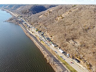
Ferryville is a village in Crawford County, Wisconsin, United States. The population was 176 at the 2010 census. It is located on Wisconsin Highway 35 along the Great River Road.
Neosho is a village in Dodge County, Wisconsin, United States. The population was 574 at the 2010 census.
Aztalan is a town in Jefferson County, Wisconsin, United States. The population was 1,457 at the 2010 census. The unincorporated communities of Aztalan and Jefferson Junction are located in the town.
Farmington is a town in Jefferson County, Wisconsin, United States. The population as of the 2010 census was 1,380.
Oakland is a town in Jefferson County, Wisconsin, United States. The population was 3,100 at the 2010 census. The unincorporated communities of Breezy Knoll, Oakland, and Sylvan Mounds, as well as the census-designated place of Lake Ripley, are located in the town.
Boaz is a village in Richland County, Wisconsin, United States. According to the 2010 census, the population of the village was 156.
Yuba is a village in Richland County, Wisconsin, United States. The population was 74 at the 2010 census. Yuba is 11 miles southwest of Hillsboro and 17 miles north of Richland Center. County Hwy C runs through the village.
Sauk City is a village in Sauk County, Wisconsin, United States. The population was 3,518 as of the 2020 census. The first incorporated village in the state, the community was founded by Agoston Haraszthy and his business partner, Robert Bryant.
West Baraboo is a village along the Baraboo River in Sauk County, Wisconsin, United States. The population was 1,627 at the 2020 census. It is part of the Baraboo micropolitan statistical area.
Woodville is a village in St. Croix County, Wisconsin, United States. The population was 1,344 at the 2010 census.
Lac La Belle is a village located mostly in Waukesha County in the U.S. state of Wisconsin. The population was 281 at the 2020 census. The village is located mostly within the town of Oconomowoc in Waukesha County. On March 28, 2002, the village annexed a portion of land in the town of Ixonia in Jefferson County.
Viola is a village in Richland (mostly) and Vernon counties in the U.S. state of Wisconsin. The population was 699 at the 2010 census. Of this, 477 were in Richland County, and 222 were in Vernon County.
Watertown is a town in Jefferson County, Wisconsin, United States. The population was 1,975 at the 2010 census. The unincorporated community of Ebenezer is located in the town.
Mount Hope is a village in Grant County, Wisconsin, United States. The population was 225 at the 2010 census. The village is located within the Town of Mount Hope.
Jefferson is a town in Jefferson County, Wisconsin, United States. The population was 2,178 at the 2010 census. The city of Jefferson is located partially within the town. The census-designated place of Helenville is also located in the town.
Jefferson is a city in Jefferson County, Wisconsin, United States, and is its county seat. It is at the confluence of the Rock and Crawfish rivers. The population was 7,793 at the 2020 census. The city is partially bordered by the Town of Jefferson.
Sullivan is a town in Jefferson County, Wisconsin, United States. The population was 2,208 at the 2010 census. The village of Sullivan, the census-designated place of Rome, and the unincorporated communities of Heath Mills, Oak Hill, and Slabtown are located in the town.
Oxford is a village in Marquette County, Wisconsin, United States. The population was 537 at the 2020 census. The village is located within the Town of Oxford. The Union Pacific Railroad runs through the town and over Neenah Lake to the northwest.
Hillsboro is a city in Vernon County, Wisconsin, United States. The population was 1,397 at the 2020 Census. The city is located within the Town of Hillsboro. Hillsboro is known as the Czech Capital of Wisconsin.
Omro is a city in Winnebago County, Wisconsin, United States. The population was 3,517 at the 2010 census. The city is located along the Fox River, approximately 10 miles west of Oshkosh, Wisconsin.