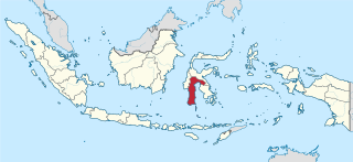
South Sulawesi is a province in the southern peninsula of Sulawesi. The Selayar Islands archipelago to the south of Sulawesi is also part of the province. The capital is Makassar. The province is bordered by Central Sulawesi and West Sulawesi to the north, the Gulf of Bone and Southeast Sulawesi to the east, Makassar Strait to the west, and Flores Sea to the south.
Makassar is the capital of the Indonesian province of South Sulawesi. It is the largest city in the region of Eastern Indonesia and the country's fifth-largest urban center after Jakarta, Surabaya, Bandung, and Medan. The city is located on the southwest coast of the island of Sulawesi, facing the Makassar Strait. Makassar is not only the gateway of Eastern Indonesia, but also the epicenter of West and East Indonesia, as well as between Australia and Asia.

East Kalimantan is a province of Indonesia. Its territory comprises the eastern portion of Borneo. It had a population of about 3.03 million at the 2010 Census and 3.42 million at the 2015 Census; the latest official estimate is 3,619,700. Its capital is Samarinda.

Samarinda is the capital city of the Indonesian province of East Kalimantan on the island of Borneo. The city lies on the banks of the Mahakam River with a land area of 718 km2 (277 sq mi). It is the most populous city on the entire Borneo island, with an estimated population of 842,691, up from 726,223 at the 2010 Census. Although it is the capital of East Kalimantan, some government institutions such as the Regional Police and 6th Military Regional Command of Mulawarman headquarters are located in Balikpapan instead. Samarinda is known for its traditional food amplang, as well as the cloth sarung samarinda. The city also has a bridge connecting its river banks, Mahakam Bridge. The city center is on one side and the other side is named Samarinda Seberang.

Parepare is a city (kota) in South Sulawesi, Indonesia, located on the southwest coast of Sulawesi, about 155 km (96 mi) north of the provincial capital of Makassar. A port town, it is one of the major population centers of the Bugis people. The city has a population of 129,542 people, according to the 2010 Census.

Pangandaran is a town and district of Pangandaran Regency within the province of West Java, Indonesia. It is located on the southern coast of the island of Java. A well-known surfing beach has made Pangandaran a popular tourist destination.
Sleman is seat capital of Sleman Regency, Indonesia. It is on the road between Yogyakarta and Magelang. It is in the regency that is home to Mount Merapi, which started its most recent eruption in late October and early November 2010, killing hundreds, including Maridjan, the spiritual keeper of the legendary spirits of the famous volcano, Indonesia's most active.
Polewali is the capital of the Polewali Mandar Regency of West Sulawesi, Indonesia.

Bima is a city on the eastern coast of the island of Sumbawa in central Indonesia's province West Nusa Tenggara. It is the largest city on the island of Sumbawa, with a population of 142,443 at the 2010 Census, but the latest official estimate is 148,984. It is separate from the adjoining Regency of Bima which had a population of 407,636 at the 2010 Census.

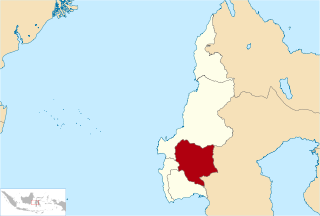
Gowa is a regency in the province of South Sulawesi, Indonesia. It has an area of 1,883 km² and a population of 652,329 at the 2010 Census; the latest official estimate is 751,981. The majority of the Regency lies within the official metropolitan area of the city of Makassar, including the regency's administrative capital at Sungguminasa. The hill resort of Malino is within the eastern (non-metropolitan) part of the regency.
Pinrang Regency is one of the twenty-one regencies in South Sulawesi Province of Indonesia. Pinrang town is the administrative capital of Pinrang Regency. The population of Pinrang Regency was 351,161 at the 2010 Census.

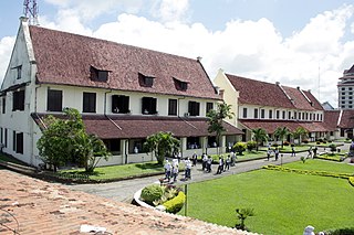
Sultan Hasanuddin was the 16th Ruler of The Sultanate of Gowa as Sombaya Ri Gowa XVI from 1653 to 1669. He was proclaimed as Indonesian National Hero on 6 November 1973. The Dutch called Sultan Hasanuddin "the Rooster of the East" as he was described as aggressive in battle.

The Jeneberang is a river of approximately 75 km in length in the south-western half of the island of Sulawesi, Indonesia. The catchment has an area of 760 square kilometers.

The Pangkajene is a river of south-western Sulawesi, north of Makassar, Indonesia, about 1400 km northeast of capital Jakarta.
Mamasa Regency is one of the five regencies that make up the West Sulawesi Province, Indonesia, on the island of Sulawesi. The population was 139,962 in the 2010 Census. Its capital is the Mamasa district, and the Toraja are the most common ethnic group.
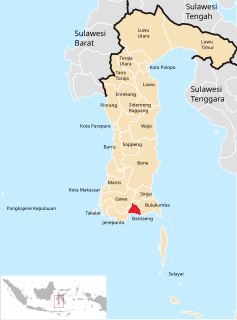
Bantaeng Regency is a regency of South Sulawesi, Indonesia. The administrative centre is the town of Bantaeng, which lies on the south coast of the southern peninsula of Sulawesi island.
Enrekang Regency is a regency of South Sulawesi Province of Indonesia. The principal town lies at Enrekang.

Luwu Regency is a regency of South Sulawesi Province, Indonesia. The administrative capital lies at Belopa, since the former capital of Palopo became an independent municipality (city) in 2006, at which date the then existing Luwu Regency was split into four entities - Palopo city, North Luwu Regency, East Luwu Regency, and the residual Luwu Regency. The regency now covers 3,000.25 km2 and had a population of 287,472 at the 2010 Census; the official estimate for 2015 was 350,218.

Somba Opu is a district located in the Gowa Regency. South Sulawesi, Indonesia, and is part of the greater Makassar area. Somba Opu is one of 18 districts in Gowa Regency. The capital of Gowa, "Sungguminasa" is located in this district and this is the largest regency capital or 2nd largest city in South Sulawesi. A suburb to Makassar, the subdistrict is a relatively urbanized area, and can also be called as the city's bedroom community.
On 22 January 2019, floods caused by heavy rainfall struck the Indonesian province of South Sulawesi. At least 68 people were killed and thousands were displaced. Gowa Regency was particularly hard-hit, experiencing the majority of the fatalities.
