
Cape May County is the southernmost county in the U.S. state of New Jersey. Much of the county is located on Cape May bound by Delaware Bay to its west and the Atlantic Ocean to its south and east. Adjacent to the Atlantic coastline are five barrier islands that have been built up as seaside resorts. A consistently popular summer destination with 30 miles (48 km) of beaches, Cape May County attracts vacationers from New Jersey and surrounding states, with the summer population exceeding 750,000. Tourism generates annual revenues of about $6.6 billion as of 2018, making it the county's single largest industry. The associated leisure and hospitality industries are Cape May's largest employers. Its county seat is the Cape May Court House section of Middle Township.

Lower Township is a township in Cape May County, in the U.S. state of New Jersey. It is part of the Ocean City metropolitan statistical area, which covers the entire county for statistical purposes. As of the 2020 U.S. census, the township's population was 22,057, a drop of 809 from the 2010 census count of 22,866, which reflected a decrease of 79 (−0.3%) from the 22,945 counted in the 2000 census.

The Cape May–Lewes Ferry is a ferry system in the United States that traverses a 17-mile (27 km) crossing of the Delaware Bay connecting North Cape May, New Jersey with Lewes, Delaware. The ferry constitutes a portion of U.S. Route 9 and is the final crossing of the Delaware River-Delaware Bay waterway before it meets the Atlantic Ocean.

The Jersey Shore is the coastal region of the U.S. state of New Jersey. Geographically, the term encompasses about 141 miles (227 km) of oceanfront bordering the Atlantic Ocean, from Perth Amboy in the north to Cape May Point in the south. The region includes Middlesex, Monmouth, Ocean, Atlantic, and Cape May counties, which are in the central and southern parts of the state. Located in the center of the Northeast Megalopolis, the northern half of the shore region is part of the New York metropolitan area, while the southern half of the shore region is part of the Delaware Valley, a.k.a. the Philadelphia metropolitan area. The Jersey Shore hosts the highest concentration of oceanside boardwalks in the United States.
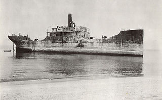
SS Atlantus is the most famous of the twelve concrete ships built by the Liberty Ship Building Company in Brunswick, Georgia, United States, during and after World War I.

The Cape May Lighthouse is a lighthouse located in the U.S. state of New Jersey at the tip of Cape May, in Lower Township's Cape May Point State Park. It was built in 1859 under the supervision of U.S. Army engineer William F. Raynolds, was automated in 1946, and continues operation to this day.
Concrete ships are built of steel and ferrocement instead of more traditional materials, such as steel or wood. The advantage of ferrocement construction is that materials are cheap and readily available, while the disadvantages are that construction labor costs are high, as are operating costs. During the late 19th century, there were concrete river barges in Europe, and during both World War I and World War II, steel shortages led the US military to order the construction of small fleets of ocean-going concrete ships, the largest of which was the SS Selma. United States Maritime Administration (MARAD) designation for concrete ships-barges was Type B ship. Few concrete ships were completed in time to see wartime service during World War I, but during 1944 and 1945, concrete ships and barges were used to support U.S. and British invasions in Europe and the Pacific. Since the late 1930s, there have also been ferrocement pleasure boats.

Cape May Point State Park is a 244 acres (0.99 km2) state park located in Lower Township, New Jersey, with a Cape May Point postal address. The park offers walking, hiking and nature trails as well as beaches, an exhibit gallery, a ranger office and is the site of the Cape May Light. The park is operated and maintained by the New Jersey Division of Parks and Forestry.
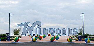
The Wildwoods are a group of five communities in Cape May County, New Jersey. These are situated on the Island of Five Mile Beach, a barrier island facing the Atlantic Ocean. These Jersey Shore communities have relatively small year-round populations that swell significantly during the summer with vacationers.

The Cape May Canal is a 2.9-nautical mile waterway connecting Cape May Harbor to the Delaware Bay, at the southern tip of Cape May County, New Jersey. There is a long history of unfulfilled plans for a canal across Cape May. The canal was finally constructed by the United States Army Corps of Engineers during World War II to provide a protected route to avoid German U-boats operating off Cape May Point and to become part of the Intracoastal Waterway. The canal was dredged as a wartime emergency measure in 1942 and was the final link in a protected waterway intended to allow coastal shipping to travel along the coast with a greatly reduced risk of attack from German submarines.
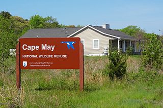
The Cape May National Wildlife Refuge is a protected area on the Cape May Peninsula in Cape May County, New Jersey. It is part of the National Wildlife Refuge System and managed by the United States Fish and Wildlife Service. Established in January 1989 with 90 acres (0.36 km2) acquired from the Nature Conservancy, it has since grown to more than 11,000 acres (45 km2) in size, and plans call for its further expansion to more than 21,200 acres (86 km2). It comprises three distinct and non-contiguous units: the Delaware Bay Division, the Great Cedar Swamp Division and the Two Mile Beach Unit. Located in the Middle Atlantic coastal forests ecoregion, the cape provides habitat for large numbers of migratory birds.
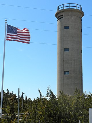
Fire Control Tower No. 23 is a NRHP-listed tower located in Lower Township, Cape May County, New Jersey, United States. The tower was built in 1942 as part of Fort Miles, the system of harbor defenses of the Delaware Bay. It was one of 15 towers from North Wildwood, New Jersey to Bethany Beach, Delaware used to aim coastal batteries at German ships and submarines. It is located near Sunset Beach in Cape May Point State Park.
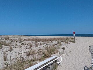
Poverty Beach or Sewell Point is a barrier spit, approximately 2.5 miles (4 km) in length entirely within the City of Cape May, along the Atlantic Ocean coast of eastern New Jersey in the United States. It is the southernmost barrier island in New Jersey.

Natali Vineyards is a winery in the Goshen section of Middle Township in Cape May County, New Jersey, USA. Formerly a pasture for horses, the vineyard was first planted in 2001, and opened to the public in 2007. Natali has seven acres of grapes under cultivation, and produces 1,800 cases of wine per year. The winery is named after the vintner and co-owner of the winery.
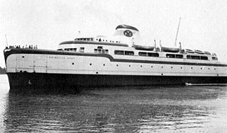
The SS Princess Anne was a Virginia Ferry Company (VFC) steam ship that plied the route across Chesapeake Bay between Little Creek, near Norfolk, and Kiptopeke Beach, at the southern end of the Eastern Shore of Virginia. She was known for her streamlined superstructure designed by Raymond Loewy, which attracted the attention of the newsreels and the nautical press.
Five Mile Beach or Holly Beach is the name of a barrier island on the Jersey Shore in Cape May County. The popular resort area collectively known as The Wildwoods are on Five Mile Beach and adjacent islands.
Two Mile Beach is a barrier island on the Jersey Shore in Cape May County, since 1922 connected to Five Mile Beach.
Cape May Inlet is an inlet in southeastern Cape May County, New Jersey.

Turtle Gut Inlet was an inlet located in what is now Wildwood Crest, in Cape May County, New Jersey, United States.

Higbee Beach Wildlife Management Area is a 1,159-acre (469 ha) wildlife management area in Lower Township, Cape May County, New Jersey.

