Surface Water and Ocean Topography

Last updated

Surface Water and Ocean Topography
SWOT spacecraft model.png
SWOT satellite
NamesSWOT
Mission type Hydrology, Oceanography
Operator NASA / CNES
COSPAR ID 2022-173A OOjs UI icon edit-ltr-progressive.svg
Mission durationPlanned: 3 years
Elasped: 1 year, 4 months, 3 days
Spacecraft properties
Spacecraft typeSurface Water and Ocean Topography
Bus SWOT
Manufacturer Thales Alenia Space
Launch mass2000 kg
Start of mission
Launch date16 December 2022 [1]
Rocket Falcon 9
Launch site Vandenberg, SLC-4E
Contractor SpaceX
Orbital parameters
Reference system Geocentric orbit
Regime Low Earth orbit
Periapsis altitude 857 km (533 mi)
Apoapsis altitude 857 km (533 mi)
Inclination 77.6°
Period 102.89 minutes
Repeat interval1 sidereal day
NASA Virtual guest program 19.png
Alternate SWOT Mission Patch by NASA  

The Surface Water and Ocean Topography (SWOT) mission is a satellite altimeter jointly developed and operated by NASA and CNES, the French space agency, in partnership with the Canadian Space Agency (CSA) and UK Space Agency (UKSA). [2] The objectives of the mission are to make the first global survey of the Earth's surface water, to observe the fine details of the ocean surface topography, and to measure how terrestrial surface water bodies change over time.

Contents

While past satellite missions like the Jason series altimeters (TOPEX/Poseidon, Jason-1, Jason-2, Jason-3) have provided variation in river and lake water surface elevations at select locations, SWOT will provide the first truly global observations of changing water levels, stream slopes, and inundation extents in rivers, lakes, and floodplains. In the world's oceans, SWOT will observe ocean circulation at unprecedented scales of 15–25 km (9.3–15.5 mi), approximately an order of magnitude finer than current satellites. It does this using synthetic aperture radar interferometry. [3] Because it uses wide-swath altimetry technology, SWOT will almost completely observe the world's oceans and freshwater bodies with repeated high-resolution elevation measurements, allowing observations of variations.

Context

SWOT builds on a long-standing partnership between NASA and CNES to measure the surface of the ocean using radar altimetry. This partnership began with the TOPEX/Poseidon mission (launched in 1992) and continued with the Jason series. SWOT brings together the hydrology and oceanography communities and will extend the precise, high-resolution surface topography observations into the coastal and estuarine regions.

Scientific objectives

The mission's science goals are to:

SWOT’s orbit extends from 78° S to 78° N, covering at least 86% of the globe in its three-year-long mission. SWOT revisits the same path all over the Earth every 21 days in 292 unique orbits. [6] [7]

Applications

SWOT is designed for the study and monitoring of inland waters and the oceans, such as: [8]

Management of water-sharing issues

The sharing of river water often causes friction between neighboring states, especially when there is no common technology for verification. SWOT will provide global information as input for systems monitoring transboundary river basins, including measurements of variations in reservoir water storage and estimates of river discharge.

More accurate weather and climate forecasting

SWOT will enable more accurate weather and climate forecasting, especially seasonally. The quality of weather and climate forecasting largely depends on numerical modeling that uses the state of the ocean surface and the hydrological conditions of catchment areas in their initial and boundary conditions.

Managing freshwater for urban, industrial, and agricultural consumption

Accurate knowledge of sources of available water is a key factor in decision-making for organizations involved in the distribution of water for agricultural, urban, and industrial needs. Data from SWOT will contribute at a global level by providing water supply services and distribution companies with information about major reservoirs and the largest rivers and catchment areas, thus enabling them to plan the management of water stocks further into the future.

Improved flood modeling

Flooding, whether from rivers overflowing their banks or in coastal regions, is among the most costly natural disasters. Altimetry data from the SWOT mission will make it possible to measure the 3-dimensional shape of flood waves, track floodwater levels, and improve measurements of local topographic details in floodplains. All of these will improve prediction capabilities for future floods.

Coastal ocean dynamics

Coastal ocean dynamics are important for many societal applications. They have smaller spatial and temporal scales than the dynamics of the open ocean and require finer-scale monitoring. SWOT will provide global, high-resolution observations in coastal regions for observing coastal currents and storm surges. While SWOT is not designed to monitor the fast temporal changes of the coastal processes, the swath coverage will allow us to characterize the spatial structure of their dynamics when they occur within the swath.

Reducing environmental risk and contributing to public policy-making

More generally, SWOT will help improve our knowledge of Earth's water cycle and ocean circulation, enhance our observation capacity by collecting unique data on water storage and fluxes and making them freely available, and help us better understand the physics that drives surface water and ocean dynamics. Water resources, natural risks (floods, climate change, hurricane forecasting, etc.), biodiversity, health (preventing the propagation of water-borne diseases), the agricultural sector, energy (including the management of electricity production and offshore gas and oil rigs), territorial development; all these areas and more stand to benefit from this new satellite mission.

Sensor payload

Diagram of SWOT data collection Diagram of SWOT Data Collection.jpg
Diagram of SWOT data collection

The primary instrument on SWOT is the Ka-band Radar Interferometer (KaRIn), which uses synthetic-aperture radar (SAR) technology, especially SAR interferometry. [9] Because SWOT operates at Ka-band's relatively short wavelengths, 11–7 mm (27–43 GHz) – compared to the Ku-band Jason series, 25–17 mm (12–18 GHz) – and at near-nadir incidence angles (<5°), it is designed to be uniquely appropriate for measuring water surface elevations and inundation extents.[ citation needed ]

The satellite will fly two radar antennas at either end of a 10 m (33 ft) mast, allowing it to measure the elevation of the surface across a 120 km (75 mi) wide swath. The new radar system is smaller than, but similar to, the one that flew on NASA's Shuttle Radar Topography Mission (SRTM), which made high-resolution measurements of Earth's land surface in 2000. [10]

A conventional nadir radar altimeter will also be flown, and measure just beneath the satellite, as was done on the Topex/Poseidon, Jason series, and SARAL missions. It is a "Jason-class" altimeter. [11]

History

SWOT was developed by an international group of hydrologists and oceanographers to provide a better understanding of the world's oceans and its terrestrial surface waters. [12] It will give scientists their first comprehensive view of Earth's freshwater bodies from space and much more detailed measurements of the ocean surface than ever before. [13] By 2019 the mission hardware was under active construction, algorithms to produce hydrology and oceanography data products were under final development, and calibration/validation methods and post-launch activities were being finalized. The spacecraft launched on a SpaceX Falcon 9 on 16 December 2022. [1]

Mating

Mating of SWOT Payload on satellite platform made in Thales Alenia Space Cannes Center Caspk PSOSW 107 SWOT Mating.jpg
Mating of SWOT Payload on satellite platform made in Thales Alenia Space Cannes Center

The mating of the payload made by Jet Propulsion Laboratory (JPL) took place on 11 August 2021 at Thales Alenia Space Cannes Center, France.

See also

Related Research Articles

<span class="mw-page-title-main">Altimeter</span> Instrument used to determine the height of an object above a certain point

An altimeter or an altitude meter is an instrument used to measure the altitude of an object above a fixed level. The measurement of altitude is called altimetry, which is related to the term bathymetry, the measurement of depth under water.

<span class="mw-page-title-main">EUMETSAT</span> European intergovernmental organisation

The European Organisation for the Exploitation of Meteorological Satellites (EUMETSAT) is an intergovernmental organisation created through an international convention agreed by a current total of 30 European Member States.

<span class="mw-page-title-main">Jason-1</span> Satellite oceanography mission

Jason-1 was a satellite altimeter oceanography mission. It sought to monitor global ocean circulation, study the ties between the ocean and the atmosphere, improve global climate forecasts and predictions, and monitor events such as El Niño and ocean eddies. Jason-1 was launched in 2001 and it was followed by OSTM/Jason-2 in 2008, and Jason-3 in 2016 – the Jason satellite series. Jason-1 was launched alongside the TIMED spacecraft.

<span class="mw-page-title-main">Satellite geodesy</span> Measurement of the Earth using satellites

Satellite geodesy is geodesy by means of artificial satellites—the measurement of the form and dimensions of Earth, the location of objects on its surface and the figure of the Earth's gravity field by means of artificial satellite techniques. It belongs to the broader field of space geodesy. Traditional astronomical geodesy is not commonly considered a part of satellite geodesy, although there is considerable overlap between the techniques.

<span class="mw-page-title-main">Space-based radar</span> Use of radar systems mounted on satellites

Space-based radar or spaceborne radar is a radar operating in outer space; orbiting radar is a radar in orbit and Earth orbiting radar is a radar in geocentric orbit. A number of Earth-observing satellites, such as RADARSAT, have employed synthetic aperture radar (SAR) to obtain terrain and land-cover information about the Earth.

<span class="mw-page-title-main">TOPEX/Poseidon</span> Satellite mission to map ocean surface topography

TOPEX/Poseidon was a joint satellite altimeter mission between NASA, the U.S. space agency; and CNES, the French space agency, to map ocean surface topography. Launched on August 10, 1992, it was the first major oceanographic research satellite. TOPEX/Poseidon helped revolutionize oceanography by providing data previously impossible to obtain. Oceanographer Walter Munk described TOPEX/Poseidon as "the most successful ocean experiment of all time." A malfunction ended normal satellite operations in January 2006.

<span class="mw-page-title-main">Seasat</span>

Seasat was the first Earth-orbiting satellite designed for remote sensing of the Earth's oceans and had on board one of the first spaceborne synthetic-aperture radar (SAR). The mission was designed to demonstrate the feasibility of global satellite monitoring of oceanographic phenomena and to help determine the requirements for an operational ocean remote sensing satellite system. Specific objectives were to collect data on sea-surface winds, sea-surface temperatures, wave heights, internal waves, atmospheric water, sea ice features and ocean topography. Seasat was managed by NASA's Jet Propulsion Laboratory and was launched on 27 June 1978 into a nearly circular 800 km (500 mi) orbit with an inclination of 108°. Seasat operated until 10 October 1978 (UTC), when a massive short circuit in the Agena-D bus electrical system ended the mission.

<span class="mw-page-title-main">OSTM/Jason-2</span> International Earth observation satellite mission

OSTM/Jason-2, or Ocean Surface Topography Mission/Jason-2 satellite, was an international Earth observation satellite altimeter joint mission for sea surface height measurements between NASA and CNES. It was the third satellite in a series started in 1992 by the NASA/CNES TOPEX/Poseidon mission and continued by the NASA/CNES Jason-1 mission launched in 2001.

<span class="mw-page-title-main">Sentinel-3</span> Earth observation satellite series

Sentinel-3 is an Earth observation heavy satellite series developed by the European Space Agency as part of the Copernicus Programme. It currently consists of 2 satellites: Sentinel-3A and Sentinel-3B. After initial commissioning, each satellite was handed over to EUMETSAT for the routine operations phase of the mission. Two recurrent satellites— Sentinel-3C and Sentinel-3D— will follow in approximately 2025 and 2028 respectively to ensure continuity of the Sentinel-3 mission.

<span class="mw-page-title-main">Ocean surface topography</span> Shape of the ocean surface relative to the geoid

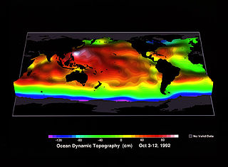
Ocean surface topography or sea surface topography, also called ocean dynamic topography, are highs and lows on the ocean surface, similar to the hills and valleys of Earth's land surface depicted on a topographic map. These variations are expressed in terms of average sea surface height (SSH) relative to Earth's geoid. The main purpose of measuring ocean surface topography is to understand the large-scale ocean circulation.

<span class="mw-page-title-main">Jason-3</span> International Earth observation satellite mission

Jason-3 is a satellite altimeter created by a partnership of the European Organisation for the Exploitation of Meteorological Satellites (EUMETSAT) and National Aeronautic and Space Administration (NASA), and is an international cooperative mission in which National Oceanic and Atmospheric Administration (NOAA) is partnering with the Centre National d'Études Spatiales. The satellite's mission is to supply data for scientific, commercial, and practical applications to sea level rise, sea surface temperature, ocean temperature circulation, and climate change.

<span class="mw-page-title-main">SARAL</span> Indian Earth observation satellite

SARAL is a cooperative altimetry technology mission of Indian Space Research Organisation (ISRO) and Centre National d'Études Spatiales (CNES). SARAL performs altimetric measurements designed to study ocean circulation and sea surface elevation.

<span class="mw-page-title-main">ADEOS I</span> Japanese Earth observation satellite

ADEOS I was an Earth observation satellite launched by NASDA in 1996. The mission's Japanese name, Midori means "green". The mission ended in July 1997 after the satellite sustained structural damage to the solar panel. Its successor, ADEOS II, was launched in 2002. Like the first mission, it ended after less than a year, also following solar panel malfunctions.

ICESat-2, part of NASA's Earth Observing System, is a satellite mission for measuring ice sheet elevation and sea ice thickness, as well as land topography, vegetation characteristics, and clouds. ICESat-2, a follow-on to the ICESat mission, was launched on 15 September 2018 onboard Delta II as the final flight from Vandenberg Air Force Base in California, into a near-circular, near-polar orbit with an altitude of approximately 496 km (308 mi). It was designed to operate for three years and carry enough propellant for seven years. The satellite orbits Earth at a speed of 6.9 kilometers per second (4.3 mi/s).

The annual cycle of sea level height describes the variation of sea level that occurs with a period of one year. Historically, analysis of the annual cycle has been limited by locations with tide gauge records, i.e., coastlines and some islands in the deep ocean, and by sparse records in the Southern Hemisphere. Since 1992, satellite-based altimeters have provided near global coverage of sea level variability, allowing for a more thorough understanding of the annual cycle both in the deep ocean and in coastal margins.

Anny Cazenave is a French space geodesist and one of the pioneers in satellite altimetry. She works for the French space agency CNES and has been deputy director of the Laboratoire d'Etudes en Geophysique et Oceanographie Spatiales (LEGOS) at Observatoire Midi-Pyrénées in Toulouse since 1996. Since 2013, she is director of Earth sciences at the International Space Science Institute (ISSI), in Bern (Switzerland).

<span class="mw-page-title-main">GEOS-3</span> Satellite

GEOS-3, or Geodynamics Experimental Ocean Satellite 3, or GEOS-C, was the third and final satellite as part of NASA's Geodetic Earth Orbiting Satellite/Geodynamics Experimental Ocean Satellite program (NGSP) to better understand and test satellite tracking systems. For GEOS 1 and GEOS 2, the acronym stands for Geodetic Earth Orbiting Satellite; this was changed for GEOS-3.

George Henry Born was an American aerospace engineer, Distinguished Professor, founder and Director Emeritus of the Colorado Center for Astrodynamics Research (CCAR) at the University of Colorado Boulder. He is known for his work in satellite navigation and precise orbit determination. He worked on various missions while at the Jet Propulsion Laboratory as well as navigation support for the Apollo program in the late 1960s while at Johnson Space Center.

<span class="mw-page-title-main">Sentinel-6 Michael Freilich</span> Earth observation satellite

The Sentinel-6 Michael Freilich (S6MF) or Sentinel-6A is a radar altimeter satellite developed in partnership between several European and American organizations. It is part of the Jason satellite series and is named after Michael Freilich. S6MF includes synthetic-aperture radar altimetry techniques to improve ocean topography measurements, in addition to rivers and lakes. The spacecraft entered service in mid 2021 and is expected to operate for 5.5 years.

Remote sensing in oceanography is a widely used observational technique which enables researchers to acquire data of a location without physically measuring at that location. Remote sensing in oceanography mostly refers to measuring properties of the ocean surface with sensors on satellites or planes, which compose an image of captured electromagnetic radiation. A remote sensing instrument can either receive radiation from the Earth’s surface (passive), whether reflected from the Sun or emitted, or send out radiation to the surface and catch the reflection (active). All remote sensing instruments carry a sensor to capture the intensity of the radiation at specific wavelength windows, to retrieve a spectral signature for every location. The physical and chemical state of the surface determines the emissivity and reflectance for all bands in the electromagnetic spectrum, linking the measurements to physical properties of the surface. Unlike passive instruments, active remote sensing instruments also measure the two-way travel time of the signal; which is used to calculate the distance between the sensor and the imaged surface. Remote sensing satellites often carry other instruments which keep track of their location and measure atmospheric conditions.

References

  1. 1 2 "Live coverage: SpaceX ready to launch U.S.-French environmental satellite". spaceflightnow.com. 16 December 2022. Retrieved 16 December 2022.
  2. Bains, Navdeep (7 March 2016). "2016-17 Report on Plans and Priorities". Canadian Space Agency. Retrieved 18 December 2022.
  3. Rodriguez, Ernesto; Fernandez, Daniel Esteban; Peral, Eva; Chen, Curtis W.; De Bleser, Jan-Willem; Williams, Brent (2017), "Wide-Swath Altimetry: A Review", Satellite Altimetry Over Oceans and Land Surfaces, CRC Press, doi:10.1201/9781315151779-2/wide-swath-altimetry-ernesto-rodriguez-daniel-esteban-fernandez-eva-peral-curtis-chen-jan-willem-de-bleser-brent-williams, ISBN   978-1-315-15177-9 , retrieved 24 March 2024{{citation}}: CS1 maint: multiple names: authors list (link)
  4. Fjørtoft, Roger; Callahan, Phil; Rodriguez, Ernesto; Desroches, Damien (21 July 2013). "Processing of KaRIn/SWOT Data". Root. Retrieved 2 November 2022.
  5. Biancamaria, Sylvain; Lettenmaier, Dennis P.; Pavelsky, Tamlin M. (1 March 2016). "The SWOT Mission and Its Capabilities for Land Hydrology" (PDF). Surveys in Geophysics. 37 (2): 307–337. Bibcode:2016SGeo...37..307B. doi:10.1007/s10712-015-9346-y. ISSN   0169-3298. S2CID   130786322.
  6. Hamoudzadeh, Alireza; Ravanelli, Roberta; Crespi, Mattia (31 March 2024). "SWOT Level 2 Lake Single-Pass Product: The L2_HR_LakeSP Data Preliminary Analysis for Water Level Monitoring". Remote Sensing. 16 (7): 1244. doi: 10.3390/rs16071244 . ISSN   2072-4292.
  7. "Swath Visualizer | Mission". NASA SWOT. Retrieved 15 January 2023.
  8. Fu, Lee‐Lueng; Pavelsky, Tamlin; Cretaux, Jean‐Francois; Morrow, Rosemary; Farrar, J. Thomas; Vaze, Parag; Sengenes, Pierre; Vinogradova‐Shiffer, Nadya; Sylvestre‐Baron, Annick; Picot, Nicolas; Dibarboure, Gerald (28 February 2024). "The Surface Water and Ocean Topography Mission: A Breakthrough in Radar Remote Sensing of the Ocean and Land Surface Water". Geophysical Research Letters. 51 (4). doi: 10.1029/2023GL107652 . ISSN   0094-8276.
  9. "SWOT: Technology". swot.jpl.nasa.gov. Archived from the original on 24 July 2009. Retrieved 19 April 2017.PD-icon.svg This article incorporates text from this source, which is in the public domain .
  10. "NASA's Shuttle Radar Topography Mission". www2.jpl.nasa.gov. Retrieved 18 December 2022.PD-icon.svg This article incorporates text from this source, which is in the public domain .
  11. "Flight Systems | Mission - NASA SWOT" . Retrieved 1 November 2023.
  12. "SWOT Science". swot.jpl.nasa.gov. Archived from the original on 18 June 2019. Retrieved 18 December 2022.PD-icon.svg This article incorporates text from this source, which is in the public domain .
  13. "The Surface Water and Ocean Topography Mission". swot.jpl.nasa.gov. Archived from the original on 23 June 2018. Retrieved 18 December 2022.PD-icon.svg This article incorporates text from this source, which is in the public domain .