Mindanao is the second-largest island in the Philippines, after Luzon and seventh-most populous island in the world. Located in the southern region of the archipelago, the island is part of an island group of the same name that also includes its adjacent islands, notably the Sulu Archipelago. As of 2015 census, Mindanao has 25,700,000 inhabitants, while the entire island group has an estimated population of 27,021,036 as of 2021.

Agusan del Norte, officially the Province of Agusan del Norte, is a province in the Caraga region of the Philippines. Its capital is the city of Cabadbaran with several government offices located in the city of Butuan. It is bordered on the northwest by Butuan Bay; northeast by Surigao del Norte; mid-east by Surigao del Sur; southeast by Agusan del Sur, and southwest by Misamis Oriental.
Agusan del Sur, officially the Province of Agusan del Sur, is a province in Caraga region, Mindanao, Philippines. Its capital is the municipality of Prosperidad. It is bordered on the northwest by Agusan del Norte and Misamis Oriental; east by Surigao del Sur; southeast by Davao Oriental; mid-south by Davao de Oro; southwest by Davao del Norte and, mid-west by Bukidnon. It is the fourth largest province in the country in terms of area.

Surigao del Norte is a province in the Philippines located in the Caraga region of Mindanao. The province was formerly under the jurisdiction of Region 10. Its capital is Surigao City. The province comprises two major islands—Siargao and Bucas Grande—in the Philippine Sea, plus a small area at the northeastern tip of mainland Mindanao and other surrounding minor islands and islets. This mainland portion borders Agusan del Norte – between the Municipality of Alegria, Surigao del Norte and the Municipality of Kitcharao, Agusan del Norte; and Surigao del Sur, to the south.

Surigao del Sur is a province in the Philippines located in the Caraga region in Mindanao. Its capital is Tandag City. Surigao del Sur is situated at the eastern coast of Mindanao and faces the Philippine Sea to the east.

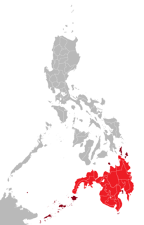
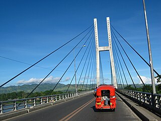
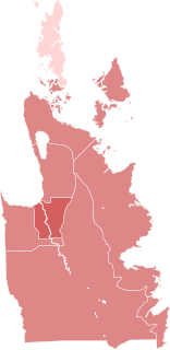
Caraga, officially the Caraga Administrative Region and designated as Region XIII, is an administrative region in the Philippines occupying the northeastern section of Mindanao. The region was created through Republic Act No. 7901 on February 23, 1995. The region comprises five provinces: Agusan del Norte, Agusan del Sur, Dinagat Islands, Surigao del Norte, and Surigao del Sur; six cities: Bayugan, Bislig, Butuan, Cabadbaran, Surigao and Tandag; 67 municipalities and 1,311 barangays. Butuan, the most urbanized city in Caraga, serves as the regional administrative center.

Tandag, officially the City of Tandag, is a 5th class component city and capital of the province of Surigao del Sur, Philippines. According to the 2020 census, it has a population of 62,669 people.
Bislig, officially the City of Bislig, is a 3rd class component city in the province of Surigao del Sur, Philippines. According to the 2020 census, it has a population of 99,290 people.
Surigaonon is an Austronesian language spoken by Surigaonon people. As a regional Philippine language, it is spoken in the province of Surigao del Norte, Dinagat Islands, Surigao del Sur, and some portions of Agusan del Norte, especially the towns near the Mainit Lake, Agusan del Sur and Davao Oriental.

Cantilan, officially the Municipality of Cantilan, is a 2nd class municipality in the province of Surigao del Sur, Philippines. According to the 2020 census, it has a population of 34,060 people.
Butuan, officially the City of Butuan, is a 1st class highly urbanized city in the region of Caraga, Philippines. It is the de facto capital of the province of Agusan del Norte where it is geographically situated but governed administratively independent. According to the 2020 census, it has a population of 372,910 people.

San Francisco, officially the Municipality of San Francisco, is a 1st class municipality in the province of Agusan del Sur, Philippines. According to the 2020 census, it has a population of 80,760 people.

Surigao City, officially the City of Surigao, is a 3rd class component city and capital of the province of Surigao del Norte, Philippines. According to the 2020 census, it has a population of 171,107 people.

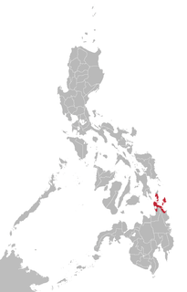
The Dinagat Islands are a group of islands constituting a province in the Caraga region in the Philippines, located on the south side of Leyte Gulf. The island of Leyte is to its west, across Surigao Strait, and Mindanao is to its south. Its main island, Dinagat, is about 60 kilometres (37 mi) from north to south. Declared a province in 2006, the Dinagat Islands comprise the second newest province of the Philippines, with Davao Occidental (2013) being the newest.
The Surigaonon people are an ethnolingustic group who inhabited on the eastern coastal plain of Mindanao, particularly the provinces of Surigao del Norte, Surigao del Sur and Dinagat Islands. They are also present in the provinces of Agusan del Norte, Agusan del Sur, and in Davao Oriental. They are part of the Bisaya people, who constitute the largest Filipino ethnolinguistic group in the country.

The Butuanon are an ethnolinguistic group who inhabited in the region of Caraga. They are part of the wider Visayan ethnolingustic group, who constitute the largest Filipino ethnolinguistic group in the country.

The southern island group of Mindanao in the Philippines is divided into six administrative regions. Each region is subdivided into provinces.

Caraga Region is located at northeastern part of Mindanao. It includes the five provinces of Dinagat Province, Surigao del Norte, Surigao del Sur, Agusan del Norte and Agusan del Sur. Caraga Region is now hosting several mining projects producing various mineral commodities particularly but not limited to gold, copper, chrome, nickel, iron and limestone for concrete cement production. This makes the Department of Environment and Natural Resources, Mines and Geosciences Bureau, Regional Office No. 13 with Office located in Surigao City plays important role in the region's economy, job generation, social and environmental enhancement and protection and ensuring government shares through royalties and taxes.

24 Oras Northern Mindanao, formerly Testigo Northern Mindanao is a Philippine television news broadcasting program broadcast by GMA Northern Mindanao. Originally anchored by Kenneth Ragpala, it premiered on February 5, 2013 replacing Isyu Karon. Joe Legaspina served as the final anchor.
The COVID-19 pandemic in Caraga is part of the worldwide pandemic of coronavirus disease 2019 caused by severe acute respiratory syndrome coronavirus 2. The virus reached Caraga on April 6, 2020, when the first case of the disease was confirmed in Butuan. The region was the last of the Philippines' 17 regions to confirm their first case. All provinces now have at least one confirmed COVID-19 case.

