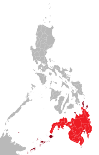
Mindanao is the second-largest island in the Philippines, after Luzon, and seventh-most populous island in the world. Located in the southern region of the archipelago, the island is part of an island group of the same name that also includes its adjacent islands, notably the Sulu Archipelago. According to the 2020 census, Mindanao has a population of 26,252,442 people, while the entire island group has an estimated population of 27,021,036 according to the 2021 census.

The Philippines is an archipelago that comprises 7,641 islands with a total land area of 300,000 square kilometers (115,831 sq mi). It is the world's fifth largest island country. The eleven largest islands contain 95% of the total land area. The largest of these islands is Luzon at about 105,000 square kilometers (40,541 sq mi). The next largest island is Mindanao at about 95,000 square kilometers (36,680 sq mi). The archipelago is around 800 kilometers (500 mi) from the Asian mainland and is located between Taiwan and Borneo.

The Battle of Leyte Gulf was the largest naval battle of World War II and by some criteria the largest naval battle in history, with over 200,000 naval personnel involved. It was fought in waters near the Philippine islands of Leyte, Samar, and Luzon from 23 to 26 October 1944 between combined American and Australian forces and the Imperial Japanese Navy (IJN), as part of the invasion of Leyte, which aimed to isolate Japan from the countries that it had occupied in Southeast Asia, a vital source of industrial and oil supplies.

Leyte is an island in the Visayas group of islands in the Philippines. It is eighth-largest and sixth-most populous island in the Philippines, with a total population of 2,626,970 as of 2020 census.

Leyte is a province in the Philippines located in the Eastern Visayas region, occupying the northern three-quarters of Leyte Island. Its capital is the city of Tacloban, administered independently from the province. Leyte is situated west of Samar Island, north of Southern Leyte and south of Biliran. To the west across the Camotes Sea is the province of Cebu.

Southern Leyte is a province in the Philippines located in the Eastern Visayas region. Its capital is the city of Maasin. Southern Leyte comprised the third congressional district Leyte until it was made into an independent province in 1959. Southern Leyte includes Limasawa, an island to the south where the first Roman Catholic Mass in Philippine soil is believed to have taken place and thus considered to be the birthplace of Roman Catholicism in the Philippines.
The Bohol Sea, also called the Mindanao Sea, is a sea located between the Visayas and Mindanao islands in the Philippines. It lies south of Bohol and Leyte and north of Mindanao. Siquijor and Camiguin are its two major islands.

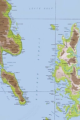
Surigao del Norte is a province in the Philippines located in the Caraga region of Mindanao. The province was formerly under the jurisdiction of Region 10 until 1995. Its capital is Surigao City. The province comprises two major islands—Siargao and Bucas Grande—in the Philippine Sea, plus a small area at the northeastern tip of mainland Mindanao and other surrounding minor islands and islets. This mainland portion borders Agusan del Norte – between the Municipality of Alegria in Surigao del Norte and the Municipality of Kitcharao in Agusan del Norte; and the province of Surigao del Sur, to the south.

Caraga, officially the Caraga Administrative Region and designated as Region XIII, is an administrative region in the Philippines occupying the northeastern section of Mindanao. The region was created through Republic Act No. 7901 on February 23, 1995. The region comprises five provinces: Agusan del Norte, Agusan del Sur, Dinagat Islands, Surigao del Norte, and Surigao del Sur; six cities: Bayugan, Bislig, Butuan, Cabadbaran, Surigao and Tandag; 67 municipalities and 1,311 barangays. Butuan, the most urbanized city in Caraga, serves as the regional administrative center.

Samar is the third-largest and seventh-most populous island in the Philippines, with a total population of 1,909,537 as of the 2020 census. It is located in the eastern Visayas, which are in the central Philippines. The island is divided into three provinces: Samar, Northern Samar, and Eastern Samar. These three provinces, along with the provinces on the nearby islands of Leyte and Biliran, are part of the Eastern Visayas region.

The San Bernardino Strait is a strait in the Philippines, connecting the Samar Sea with the Philippine Sea. It separates the Bicol Peninsula of Luzon island from the island of Samar in the south.
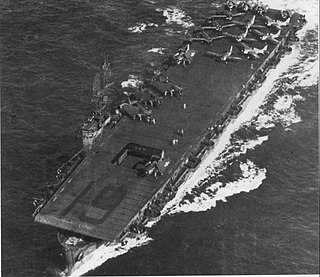
USS Manila Bay (CVE-61) was a Casablanca-class escort carrier of the United States Navy.
Battle of the Philippines may refer to several wars, military campaigns, and major battles which have been fought in the Philippine Islands, including:

Surigao City, officially known as the City of Surigao, is a 1st class component city and capital of the province of Surigao del Norte, Philippines. According to the 2020 census, it has a population of 171,107 people.

The Dinagat Islands are a group of islands constituting a province in the Caraga region in the Philippines, located on the south side of Leyte Gulf. The island of Leyte is to its west, across Surigao Strait, and Mindanao is to its south. Its main island, Dinagat, is about 60 kilometres (37 mi) from north to south. Declared a province in 2006, the Dinagat Islands comprise the second newest province of the Philippines, with Davao Occidental (2013) being the newest.

The Pan-Philippine Highway, also known as the Maharlika Highway, is a network of roads, expressways, bridges, and ferry services that connect the islands of Luzon, Samar, Leyte, and Mindanao in the Philippines, serving as the country's principal transport backbone. Measuring 3,379.73 kilometers (2,100.07 mi) long excluding sea routes, it is the longest highway in the Philippines that forms the country's north–south backbone component of National Route 1 (N1) of the Philippine highway network. The entire highway is designated as Asian Highway 26 (AH26) of the Asian Highway Network.

The Philippine Nautical Highway System, also the Road Roll-on/Roll-off Terminal System (RRTS) or simply the RoRo System, is an integrated network of highway and vehicular ferry routes which forms the backbone of a nationwide vehicle transport system in the Philippines. It is a system of roads and ports developed by the Philippine government to connect the major islands of Luzon, the Visayas and Mindanao. The 919-kilometer (571 mi) nautical highway was opened to the public on April 12, 2003 as the Strong Republic Nautical Highway (SRNH).
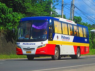
Philtranco Service Enterprises, Inc. is a bus company in the Philippines, servicing routes to Bicol, Eastern Visayas, Caraga, Davao Region, and Northern Mindanao. It is the oldest bus operator in the Philippines and in Asia. It is also the only bus carrier with a nationwide public transport franchise. Philtranco currently has more than 250 buses for its operations.

Cokaliong Shipping Lines, Inc. (CSLI) is a shipping line based in Cebu City, Philippines. It operates both passenger and cargo ferries on eight routes in the Visayas and Mindanao regions and is one of the youngest shipping companies in the Philippines.
Eastern Visayas is an administrative region in the Philippines, designated as Region VIII. It consists of three main islands, Samar, Leyte and Biliran. The region has six provinces, one independent city and one highly urbanized city namely, Biliran, Leyte, Northern Samar, Samar, Eastern Samar, Southern Leyte, Ormoc and Tacloban. The highly urbanized city of Tacloban is the sole regional center. These provinces and cities occupy the easternmost islands of the Visayas group of islands.