Sutton, Peterborough

Last updated

Sutton
St Michael Church Sutton - geograph.org.uk - 344307.jpg
Cambridgeshire UK location map.svg
Red pog.svg
Sutton
Location within Cambridgeshire
Population196 (2011) [1]
Civil parish
  • Sutton
Unitary authority
Ceremonial county
Region
Country England
Sovereign state United Kingdom
Post town Peterborough
Postcode district PE5
Dialling code 01780
Police Cambridgeshire
Fire Cambridgeshire
Ambulance East of England
List of places
UK
England
Cambridgeshire
52°34′30″N0°22′55″W / 52.575°N 0.382°W / 52.575; -0.382
Autumn colours on the River Nene near Sutton - geograph.org.uk - 1563755 Autumn colours on the River Nene near Sutton - geograph.org.uk - 1563755.jpg
Autumn colours on the River Nene near Sutton – geograph.org.uk – 1563755
Looking E from Sutton tower - geograph.org.uk - 4320 [Photo is not from St Michael's and All the Angels, it's a church from a different Sutton] Looking E from Sutton tower - geograph.org.uk - 4320.jpg
Looking E from Sutton tower – geograph.org.uk – 4320 [Photo is not from St Michael’s and All the Angels, it’s a church from a different Sutton]

Sutton is a small village and civil parish in the Peterborough district, in the north-west of Cambridgeshire, England. Situated about 5.7 miles from Peterborough and approximately half a mile south of the A47 road.

Contents

For electoral purposes it forms part of Glinton and Wittering ward in North West Cambridgeshire constituency.

According to Office for National Statistics Sutton has a population (including Upton) of 196 with a population density of 0.2.

History

20th Century Map of the surrounding area of Sutton 20th century map of Sutton.png
20th Century Map of the surrounding area of Sutton

Dating back to 972–992, the area of Peterborough was described as a "woody swamp" but was cleared to a certain degree when Abbot Adulf built manor houses and granges. [2] In 'Old English', Sutton translates as a Southern farm/settlement. The ancient church of Sutton dates back to the 12th century and was originally built as a chapel-of-ease to the church of St Kyneburgha in Castor. It is also home to a war memorial. [3] The church, now named St Michael & All Angels, was originally dedicated to Saint Giles, the patron saint of cripples, lepers and nursing mothers. The majority of the church was rebuilt in 1867–8, but the arch supports have survived from the original construction in the 12th/13th century. [4] A grant of £37,300 was given to complete work on the church by a company called WREN in order for it to become a community hub for locals. Since the grant in 2010, the church has been improved further with such things as heating systems and carpeting. [5]

The historical layout of the village is a simple rectangle of streets engulfing a green where cattle would be, known as a Saxon nucleated settlement (or a Nucleated village), with the grange and chapel located in one corner of the rectangle. With the village being in close proximity to the River Nene, there was once a ford going over to Stibbington, but this was eventually destroyed by dredging after a long period of not being used. The Manor Farm (also known as 'The Grange') was built in the 17th century. Keith Garrett described the manor as a "fully constituted manor with its manor house or hall, its home farm, open fields, and lands of villeins, who held their dwellings and small agricultural holdings for customary services in cultivating the Abbey's home farm etc." [6]

In 1870–72, this is how John Marius Wilson's Imperial Gazetteer of England and Wales described Sutton:

SUTTON, a chapelry in Castor parish, Northampton; on the river Nen, near Wansford r. station. Acres, 880. Real property, £1,101. Pop., 112. Houses, 22. The living is a p. curacy in the diocese of Peterborough. Value, not reported. Patron, the Bishop of P. The church is ancient. Charities, £10. [7]

Population

Total change in population of Sutton from years 1881-1961 according to Census data Population of Sutton 1881-1961.png
Total change in population of Sutton from years 1881–1961 according to Census data

As mentioned previously, the total population of Sutton is at 196 according to the Office for National Statistics for 2011 Census. Between the years of 1881 and 1961 the overall trend shows that population declined, however with some anomalies. The recorded population fluctuated from 1881– In 1881 the total population of Sutton is 92, which then dropped the following ten years to 84. The population peaked in this time period when it rose back up to 98 by 1901, followed by an overall decline of 20 in the 20 years from 1901 to 1921. Just 10 years later, the population grew rapidly to 91 in 1931 which was followed by a fall of 27 over the next 20 years. No census information was found for the population in 1941, shown in the graph, but the population declined further to 58 by the year 1961. We can compare the figures over these years with the population census report for Sutton in 2011, which was 196, showing an increase of 138 residents in Sutton over these 50 years. [8]

Sutton is sparsely populated with a population density of 0.2, showing that the parish it is not a heavily residential area. Using Census data we can also see the change in male and female residents of Sutton over time. Since 1881 there have been slightly more females in this area than males. In 1881 52 females were counted in comparison to just 40 males. Ten years later this changed as only 41 females were recorded to a score of 43 males. Up until 1921 the 2 Census reports showed more females than males occupying the parish. The male numbers remained above the female population in the 1931 Census and were equal with 32 residents recorded of both sexes 20 years on in the 1951 census. By 1961 the female population regained dominance as there were 4 more females than males. [9] Of the 196 residents recorded in the 2011 population census there were 103 male inhabitants to that of 93 female. [10]

169 of the 196 residents of Sutton are English-born according to 2011 census data, in comparison to 176 of 190 residents in 2001, showing that there was an increase in foreign-born people populating Sutton over these 10 years. [11] Using Neighbourhood Statistics we can also analyse the population structure over the last 10 years. In the 2001 census 122 of 190 residents were aged between 30 and 74, showing a majority working population. In the 2011 census there were also 122 people living in sutton from the ages of 30–74 with 52 residents aged from 45 to 59 and a mean average age of 47.3.

The average age of the population of Sutton as a whole, is older than the national average and the Cambridgeshire average, suggesting that it has an ageing population. [12]

Employment

Bar Graph showing Sutton's breakdown of industries according to ONS 2011 census Occupation Suttton NEW.png
Bar Graph showing Sutton's breakdown of industries according to ONS 2011 census
Sutton's Occupational Orders 1881 Sutton's Occupational Orders 1881.png
Sutton's Occupational Orders 1881

Two bar graphs that can be seen in this section portray the occupational orders in Sutton 130 years apart. The bar chart to the right shows Sutton's occupational orders in 1881, and what is distinctly noticeable about it is the large number of male residents who were involved in agriculture as an occupation, 28 to be specific. [13] Having such a large proportion of males involved in agriculture could become a problem at this time due to the agricultural depression (Long Depression) which could be a contributor to the fall in population of Sutton in the early 20th century (shown in population graph in the demographics section). It is also evident that 13 females occupations were unknown in the 1881 census. This is due to the fact in the Victorian Era, women's work was most likely based around home and family and was inaccurately recorded. The work they could obtain in the factories or in domestic service wouldn't be consistent. [14]

The most noticeable change between the two graphs is the decrease in number of people working in the agricultural sector due to the shift in industry from primary industries to that of more technologically advanced industries over the 19th and 20th centuries. The graph shows that the 2 highest occupations in the 2011 census were retail trade and education where precisely 13 economically active residents worked. [15]

In 2014, the area of Peterborough has an unemployment rate of 6.9% of the working population where 79.4% are recorded as economically active. [16] This shows that Sutton is within an area of high unemployment in comparison to the national figure of 5.5%. According to the 2011 Census, 94 residents of the total 138 from the working population are seen to be economically active, whereas the remaining 44 are inactive due to a number of situations such as; retired, sick or disabled or looking after family. [17]

Housing

Line chart showing the change in number of houses from 1881 to 1961 according to ordnance survey census data Sutton housing 81-1961.png
Line chart showing the change in number of houses from 1881 to 1961 according to ordnance survey census data

The Area of Sutton has a higher rate of home ownership than the national and Cambridgeshire average, showing that Sutton is a fairly affluent area. The maximum number of houses from the time period 1881–1961 was just 25, with 23 in 1881 and 24 in 1961. [18] The change in number of houses over this time was fairly stagnant. From the 1961 census to the 2011 census the number of houses in Sutton has increased to 74. 55.4% of these houses were owned outright, again showing the affluence of the area. [19] Sutton has developed and grown through building more houses over this time. Data taken from the 2011 census shows that 51 of the 74 houses are detached and 23 semi-detached with no flats in the village at all. [20]

Related Research Articles

<span class="mw-page-title-main">Winwick, Cambridgeshire</span> Human settlement in England

Winwick is a village and civil parish in Cambridgeshire, England. Winwick lies approximately 10 miles (16 km) north-west of Huntingdon. It is a crossroads village on the B660 near Hamerton. Winwick is situated within Huntingdonshire which is a non-metropolitan district of Cambridgeshire as well as being a historic county of England.

<span class="mw-page-title-main">Old Weston</span> Human settlement in England

Old Weston – in Huntingdonshire, England – is a village near Molesworth west of Huntingdon.

Chesterton is a small village and civil parish of exactly 56 households in Cambridgeshire, England. The village lies approximately 5 miles (8 km) west-southwest of central Peterborough, near the city's Alwalton district. Chesterton is situated within Huntingdonshire which is a non-metropolitan district of Cambridgeshire as well as being a historic county of England.

<span class="mw-page-title-main">Glatton</span> Village in Cambridgeshire, England

Glatton is a village and civil parish in Cambridgeshire, England, some 8 miles (13 km) south-west of Peterborough, near the villages of Conington, Yaxley and Stilton. It lies in the non-metropolitan district of Huntingdonshire, which is part of Cambridgeshire as well as being a historic county. A World War II airfield built nearby is now known as Peterborough's Conington Airport.

<span class="mw-page-title-main">Great Gidding</span> Human settlement in England

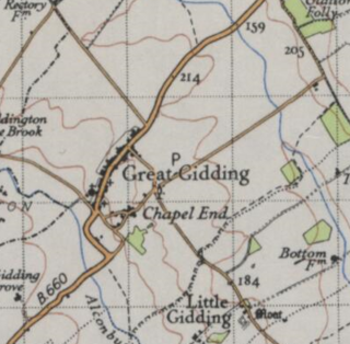
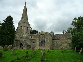
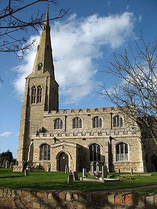
Great Gidding is a village and civil parish in the Huntingdonshire district of Cambridgeshire, England.

<span class="mw-page-title-main">Hail Weston</span> Human settlement in England

Hail Weston is a village and civil parish in Cambridgeshire, England. Hail Weston lies approximately 7 miles (11 km) south of Huntingdon. Hail Weston is situated within Huntingdonshire which is a non-metropolitan district of Cambridgeshire as well as being a historic county of England.

<span class="mw-page-title-main">Easton, Cambridgeshire</span> Human settlement in England

Easton is a village and civil parish in Cambridgeshire, England. Easton lies approximately 6 miles (10 km) west of Huntingdon, between the villages of Ellington and Spaldwick. Easton is situated within Huntingdonshire which is a non-metropolitan district of Cambridgeshire as well as being a historic county of England. Easton is a hamlet which the Anglo Saxons settled in.

<span class="mw-page-title-main">Ellington, Cambridgeshire</span> Human settlement in England

Ellington is a village and civil parish in Cambridgeshire, England, 4 miles (6 km) west of Huntingdon in Huntingdonshire, a non-metropolitan district of Cambridgeshire and historic county of England. The civil parish covers an area of 2,700 acres ; much of it is grassland with some small woods in the south of the parish.

<span class="mw-page-title-main">Holmer and Shelwick</span> Human settlement in England

Holmer and Shelwick is a civil parish in Herefordshire, England. It is immediately to the north of Hereford and includes Holmer, Munstone, Shelwick and Shelwick Green. It is surrounded by rural fields, however the amenities of Hereford are very close by.

<span class="mw-page-title-main">Belstead</span> Human settlement in England

Belstead is a village and civil parish in the Babergh district of the English county of Suffolk. Located on the southern edge of Ipswich, around 3 miles (5 km) south-west of Ipswich town centre. It had a population of 202 according to the 2011 census. Belstead has amenities such as a village hall, St Mary's the Virgin Church, The bridge school for children with learning difficulties and Belstead Brook Hotel and Spa. It is in the Belstead Brook electoral division of Suffolk County Council.

<span class="mw-page-title-main">Borough Fen</span> Human settlement in England

Borough Fen is a civil parish in the City of Peterborough unitary authority in Cambridgeshire, England. The parish is to the north of Peterborough city centre, just below the county border with Lincolnshire. Much of the land in the 19th century was owned by Sir Culling Eardley, 3rd Baronet, a strong supporter of the local boys' school. The land has predominantly been used for agriculture and cattle farming which is still a significant employment sector today.

Described by John Marius Wilson in 1870 as "BOROUGH-FEN (Ville), an extra-parochial tract in Peterborough district, Northampton; 5 miles N by E of Peterborough. Acres, 3,130. Real property, £6,086. Pop., 202. Houses, 31."

<span class="mw-page-title-main">Parham, Suffolk</span> Village and civil parish in Suffolk, England

Parham is a village and civil parish in the East Suffolk district of Suffolk in eastern England. Located seven miles north of Woodbridge, in 2005 it had a population of 300, reducing to 263 at the 2011 census and according to the 2011 census there were 129 males and 134 females living at this time.

<span class="mw-page-title-main">Newborough, Cambridgeshire</span> Human settlement in England

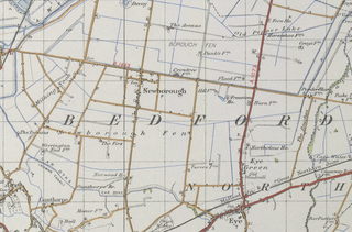
Newborough is a village and a civil parish in the Peterborough district, in the ceremonial county of Cambridgeshire, England. Newborough is situated 7.62 km (4.74 mi) north of Peterborough. Newborough has a population of 1,670 according to the 2011 census

<span class="mw-page-title-main">Marholm</span> Human settlement in England

Marholm is a village and civil parish in the Peterborough district, in the ceremonial county of Cambridgeshire, England. West of Peterborough and 1 mile from the seat of the Fitzwilliam family at Milton Hall. The parish covers some 1,400 acres, with the village positioned roughly in the centre. For electoral purposes it forms part of Northborough ward in North West Cambridgeshire constituency.

<span class="mw-page-title-main">Wentworth, Cambridgeshire</span> Human settlement in England

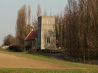
Wentworth is a small village near Ely in Cambridgeshire, England. It is in the Isle of Ely, adjacent to Grunty Fen, Wentworth lies south of the A142 between Witchford and Sutton, approximately 5 miles west of Ely. The village is centred on St Peter’s Church and a number of listed buildings at the junction of Main Street and Church Road. Residents travel to nearby settlements, including Ely for many goods and services. In 2015, there was no public transport serving the village. However, as of 2017, there is a limited bus service and the nearest railway station serving the village is Ely. In the 1870s, Wentworth, Cambridgeshire was described as:

" a parish in Ely district, Cambridge; 4½ miles W by S of Ely r. station. Post town, Ely. Acres, 1,437. Real property, £2,653. Pop., 180. Houses, 40. The living is a rectory in the diocese of Ely. Value, £450.* Patrons, the Dean and Chapter of Ely. The church is partly Norman, chiefly early English, and all good."

<span class="mw-page-title-main">Ringshall, Suffolk</span> Human settlement in England

Ringshall is a village and civil parish in the Mid Suffolk district of Suffolk in eastern England. Located around four miles south of Stowmarket, and 13 miles north west of Ipswich.

<span class="mw-page-title-main">Great Livermere</span> Human settlement in England

Great Livermere is a village and civil parish in the West Suffolk district of Suffolk in eastern England. It is located around four miles north-east of the borough's largest town Bury St Edmunds.

<span class="mw-page-title-main">Ousden</span> Human settlement in England

Ousden is a village and civil parish in the West Suffolk district of Suffolk in eastern England. It is located around 6 miles (10 km) west of Bury St Edmunds and 72 miles (116 km) north of London, and as of 2011, its population is 266. The village has an Anglican church of St Peter's and a chapel in the cemetery dedicated to St Barnabas.

<span class="mw-page-title-main">Great Tey</span> Human settlement in England

Great Tey is a village and civil parish in the City of Colchester district of Essex, England. It is near the villages of Marks Tey and Little Tey, located approximately six miles west of Colchester.

<span class="mw-page-title-main">Poughill, Devon</span> Village in Devon, England

Poughill is a village and civil parish in Devon, England. It lies 5 miles (8 km) north of Crediton. In 2011, the parish had a population of 216.

References

  1. Neighbourhood, Statistics. "2011 Census Population Firgures". Neighbourhood Statistics. Ordnance Survey. Retrieved 21 April 2015.
  2. Garrett, Keith. "Sutton Manor History". The Archive. Retrieved 23 April 2015.
  3. "List of Memorials". Roll of Honour. Retrieved 23 April 2015.
  4. Cambridgeshire Federation of Women's Institutes. The Cambridgeshire Village Book. Countryside Books. Retrieved 21 April 2015.
  5. "A Return Visit to Sutton Church, Peterborough". WREN. Retrieved 21 April 2015.
  6. Garrett, Keith. "Sutton Manor History". The Archive – History. Retrieved 23 April 2015.
  7. Wilson, John Marius (1872). Imperial Gazetteer of England and Wales. Edinburgh. Retrieved 21 April 2015.{{cite book}}: CS1 maint: location missing publisher (link)
  8. Office of National Statistics. "Population statistics". Vision of Britain. A Vision of Britain Through Time. Retrieved 21 April 2015.
  9. "Males and Females". Vision of Britain. Retrieved 21 April 2015.
  10. Statistics, Neighbourhood. "Sutton (parish) Sex, 2011". Neighbourhood Statistics. Office for National Statistics. Retrieved 21 April 2015.
  11. "People and Society: Population and Migration". Neighbourhood Statistics. Office for National Statistics. Retrieved 21 April 2015.
  12. "Sutton Age Distribution Statistics". I Live Here.
  13. "Sutton Historical Industry Statistics". Vision of Britain. Retrieved 23 April 2015.
  14. "Women and Work in the 19th century". Striking-Women. Retrieved 23 April 2015.
  15. "Industry, 2011". Neighbourhood Statistics. Office for National Statistics. Retrieved 23 April 2015.
  16. "ONS annual population survey". NomisWeb. Office for National Statistics. Retrieved 23 April 2015.
  17. "Economic Activity". Neighbourhood Statistics. Office for National Statistics. Retrieved 23 April 2015.
  18. "Historical Housing Statistics". VisionofBritain. Ordnance Survey. Retrieved 23 April 2015.
  19. "Tenure". Neighbourhood Statistics. Office for National Statistics. Retrieved 18 February 2016.
  20. "Accommodation type – households". Neighbourhood Statistics. Office for National Statistics. Retrieved 23 April 2015.

Commons-logo.svg Media related to Sutton, Peterborough at Wikimedia Commons