Tanintharyi

Last updated
Tanintharyi
တနင်္သာရီ
ဏၚ်ကသဳ
Town
Myanmar adm location map.svg
Red pog.svg
Tanintharyi
Location in Burma
Coordinates: 12°5′N99°1′E / 12.083°N 99.017°E / 12.083; 99.017
Country Flag of Myanmar.svg  Myanmar
Region Flag of Tanintharyi Region (2010-2021).svg  Tanintharyi Region
District Myeik District
Township Tanintharyi Township
Time zone UTC+6.30 (MMT)

Tanintharyi or Taninthayi (widely known during the British occupation and since as Tenasserim) is a small town in Taninthayi Township, Myeik District, in the Tanintharyi Region of south-western Myanmar. It is the administrative seat for the township. The town is located on the Great Tenasserim River which eventually enters the sea at Myeik. [1] [2] The town is located at the confluence of this river and a tributary known as the "Little Tenasserim River" which runs south.

Contents

The town is built on a hill slope on the site of an ancient city which, for hundreds of years, served as the principal port of Siam. [3] Ethnic Bamars (Burmans) (with Dawei and Myeik subgroups) are the majority community here. The hill people who are non-Buddhists are most numerous here. The majority of the population speak the Tavoyan dialect. [4] [5] [6]

Etymology

The town name has varied, often based on the nationality of the traveller. These variations include Tanaosi or Tannaw (Siamese); Tanah Sari (Malay); Tenanthari, Tanncthaice, Ta-nen-tkd-ri, and Tanang-sci (Burmese); and Ta-na-ssu-li-sen (Chinese). [7] Other sources have referred to it as Thenasserim, Tenáscri, Tciiaçar, Tanater, Tarnassari, Tenazar, Tannzzari, Tanaçari, Tanaçary, Tanaçarim, Taunararin, Tanaçarij, Tcnaiarij, Tanacarim, Tanassarim, Tenassarim, Tenasari, Tanussarin, Tenascri, Dahnnsari, Tanaseri, Tenauri, Tanasserin, Tananarino, Tenassarim, Tenassere, Tanararij, Tanassaria, Tonazarin, and Denouservn. [8]

History

The town's importance as a trade centre depended on it serving as the starting-point on the western coast of Siam as an overland route to the capital, Ayutthaya, which controlled the region during the 15th to 18th centuries. In addition, it was a port at which smaller vessels could unload their cargoes. [9] The town, along with the port cities of Dawei and Myeik, were pivotal to Ayutthaya's Indian Ocean trade.

The town enjoyed a reputation for trade with European nations since the 17th century. In 1759, the Burmese conqueror Alaungpaya invaded the town. He pillaged it the following year and further damaged it in 1765. When Ayutthaya was destroyed in 1767, the town was brought to commercial ruin. [9]

The town fell under British control in the First Anglo-Burmese War in 1824. [4]

Geography

Map showing the town and the river Great Tenasserim River.png
Map showing the town and the river

Tanintharyi lies on the southern bank of the Great Tenasserim River, tucked away into a small peninsula, with the Great Tenasserim River to the north and west and the Little Tenasserim River to the east. Settlements close to Tanintharyi include Kadaw to the west, Mawtone across the river to the north-west and Bangyok to the north-east. [1] It is characterized by a narrow coastal zone flanked by mountains, and is situated between the Gulf of Martaban and Victoria Point, just north of the Equator. The coast land has a long maritime history of trade dealings with the rest of the world, particularly India on the Coromandel coast, Siam and the Middle East. [4] [5]

Culture

Less than a mile from the present village stands and erected by the Siamese at the city's founding in 1383 AD is a large, roughly cut stone pillar weighing several tons which is said to have once been the original city centre. [10] Legend has it that a live woman was thrown into the hole where the pillar was planted and that she became the city's spiritual guardian. [10]

In earlier days, approximately 4 sq mi (10 km2) of the town were surrounded by a brick and mud wall. Though the wall has since been dismantled and the bricks repurposed within other buildings such as the jail, the wall's foundation can still be seen in certain places. [10] Its courthouse was erected on a hill above the village, and this is also the site of two ancient pagodas. [3]

In 1877, the population was approximately 666 inhabitants. [11] As of 1916, the village contained approximately 100 houses. [3]

Resources

The town's agricultural resources include the cultivation of rubber and fruit crops. Pearl farms are also established here by the Ministry of Mines. [5] Tanintharyi is located within the south-east Asian tin zone. [5]

Related Research Articles

<span class="mw-page-title-main">Dawei</span> City in Tanintharyi Region, Myanmar

Dawei is a city in south-eastern Myanmar and is the capital of the Tanintharyi Region, formerly known as the Tenasserim Division, on the northern bank of the Dawei River. The city is about 614.3 km (381.7 mi) southeast of Yangon. Its population is 146,964. Dawei is a port at the head of the Dawei River estuary, 30 km (18.6 mi). from the Andaman Sea. As a result, the city is prone to flooding during the monsoon season. "Dawei" is also the name of one of Myanmar's 135 ethnic minorities.

<span class="mw-page-title-main">Myeik, Myanmar</span> City in Tanintharyi Region, Myanmar

Myeik is a rural city in Tanintharyi Region in Myanmar (Burma), located in the extreme south of the country on the coast off an island on the Andaman Sea. As of 2010, the estimated population was over 209,000. Myeik is the largest city in Tanintharyi Region, and serves as the regional headquarters of Myanmar Navy's Tanintharyi Regional Command. The area inland from the city is a major smuggling corridor into Thailand. The Singkhon Pass, also known as the Maw-daung Pass, has an international cross-border checkpoint.

<span class="mw-page-title-main">Tanintharyi Region</span> Region of Myanmar

Tanintharyi Region is an administrative region of Myanmar, covering the long narrow southern part of the country on the upper Malay peninsula, reaching to the Kra Isthmus. It borders the Andaman Sea to the west and the Tenasserim Hills, beyond which lie Thailand, to the east. To the north is the Mon State. There are many islands off the coast, the large Mergui Archipelago in the southern and central coastal areas and the smaller Moscos Islands off the northern shores. The capital of the division is Dawei (Tavoy). Other important cities include Myeik (Mergui) and Kawthaung. The division covers an area of 43,344.9 square kilometres (16,735.6 sq mi), and had a population of 1,406,434 at the 2014 Census.

<span class="mw-page-title-main">Kyunsu Township</span> Township in Taninthayi Region, Burma

Kyunsu or Kanmaw Township is a township of Myeik District in the Taninthayi Division of Myanmar. The principal town is Kyunsu. The township constitutes much of the Mergui Archipelago to the west, northwest and southwest of the city of Mergui (Myeik). The main town is located on the north-east coast of Kanmaw Island to the southwest of Mergui city.

<span class="mw-page-title-main">Tenasserim Hills</span> Mountain range in Southeast Asia

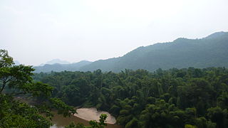
The Tenasserim Hills or Tenasserim Range is the geographical name of a roughly 1,700 km long mountain chain, part of the Indo-Malayan mountain system in Southeast Asia.

<span class="mw-page-title-main">Thado Minsaw</span> Burmese heir apparent (1762–1808)

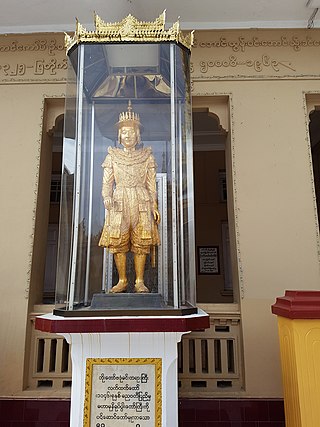
Thado Minsaw, also known as Shwedaung Min (ရွှေတောင်မင်း), was heir-apparent of Burma from 1783 to 1808, during the reign of his father King Bodawpaya of Konbaung dynasty. As Prince of Shwedaung and Dabayin, he was entrusted by the king to manage the day-to-day affairs of the kingdom, and when necessary, to lead the Royal Army against enemies. Thado Minsaw is best known for his conquest of Arakan in 1784–1785 and the subsequent removal of Mahamuni Buddha from Mrauk-U to Amarapura. He also led the successful defense of Tenasserim (Taninthayi) coast in 1792 in the war with Siam. The crown prince also led the revitalization of Burmese theater in the late 18th century by bringing a group of young artists to his court.

<span class="mw-page-title-main">Dawei River</span> River in Tanintharyi Region, Myanmar

The Dawei River or Tavoy River is a river of the Tanintharyi Region, Burma.

<span class="mw-page-title-main">Great Tenasserim River</span> River in Burma

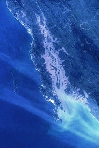
The Great Tenasserim River or the Tanintharyi River is a major river of southeastern Burma. It flows through the Tanintharyi Region, past the town of Tanintharyi, and enters the sea at Myeik (Mergui). The river rises from the Tenasserim Range at an altitude of 2,074 m (6,804 ft), and flows into the Andaman Sea. The region formed by this river is also known as Tenasserim, or Tanintharyi in Burmese. It is in a constricted coastal region in southeastern Myanmar, which borders Thailand on the east and the Andaman Sea on the west.

<span class="mw-page-title-main">Kanmaw Kyun</span>

Kanmaw Kyun or Kanmaw Island is an island in the Andaman Sea along the coast of southeastern Burma (Myanmar), and is part of the Mergui Archipelago. Administratively, it is located in Kyunsu Township, Myeik District, in the Taninthayi Region. On the northeastern side of the island is the town of Kyunsu, which is the administrative seat for the township. The island covers a total area of 409 km2.

<span class="mw-page-title-main">Burmese–Siamese War (1759–1760)</span> Conflict between the Konbuang dynasty of Burma and the Thai kingdom of Ayutthaya

The Burmese–Siamese War (1759–1760) was the first military conflict between the Konbaung dynasty of Burma (Myanmar) and the Ban Phlu Luang Dynasty of the Ayutthaya Kingdom of Siam. It reignited the centuries-long conflict between the two Southeast Asian states that would last for another century. The Burmese were "on the brink of victory" when they suddenly withdrew from their siege of Ayutthaya because their king Alaungpaya had fallen ill. He died three weeks later, ending the war.

<span class="mw-page-title-main">Burmese–Siamese War (1765–1767)</span> Conflict between the Burmese Empire and the Thai kingdom of Ayutthaya

The Burmese–Siamese War (1765–1767), also known as the fall of Ayoudhia (အယုဒ္ဓယပျက်ခန်း) was the second military conflict between the Konbaung dynasty of Burma (Myanmar) and the Ban Phlu Luang dynasty of the Ayutthaya Kingdom of Siam, and the war that ended the 417-year-old Ayutthaya Kingdom. Nonetheless, the Burmese were soon forced to give up their hard-won gains when the Chinese invasions of their homeland forced a complete withdrawal by the end of 1767. A new Siamese dynasty, to which the current Thai monarchy traces its origins, emerged to reunify Siam by 1771.

The Myeik dialect, also known as Beik in Burmese, Mergui and Merguese in English, and Marit (มะริด) in Thai, is a divergent dialect of Burmese, spoken in Myeik, the second largest town in Tanintharyi Region, the southernmost region of Myanmar. Myeik shares many commonalities with the Tavoyan dialect, although there are substantial differences especially with regard to phonology.

Phu Nam Ron is a pass across the Tenasserim Hills on the border between Thailand and Myanmar, at an elevation of 350 metres (1,150 ft). The border checkpoint on the Thai side is in Ban Kao Subdistrict, Mueang Kanchanaburi District, Kanchanaburi Province.

Myitta Subtownship is a subtownship of Dawei Township, Dawei District in the Taninthayi Division of Myanmar. The main town is Myitta (Matamyu), located on the western side of the Tenasserim Range near the confluence of two tributaries of the Great Tenasserim River.

Sinbyudaing, is a small village of Dawei District in the Taninthayi Region of Myanmar. It is located on the western side of the Tenasserim Range near the border with Thailand.

Amya is a village of Dawei District in the Taninthayi Division of Myanmar.

Kyaukton, is a village of Dawei District in the Taninthayi Division of Myanmar. It is located on the western side of the Tenasserim Range, 24 km to the northwest of Sinbyudaing.

<span class="mw-page-title-main">Lei Lei Maw</span> Burmese politician

Lei Lei Maw is a Burmese politician and a medical doctor who served as Chief Minister of Tanintharyi Region and Taninthayi Region Parliament MP for Thayetchaung Township Constituency No. 1. She was removed from her chief minister position for corruption on 11 March 2019. She is the second of only two women chief ministers appointed by President Htin Kyaw.

<span class="mw-page-title-main">Burmese–Siamese War (1792–1794)</span> Military conflict

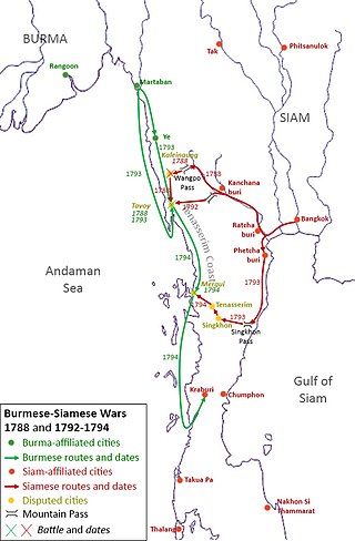
The Burmese–Siamese War (1792–1794) or the Siamese Invasion of Tavoy was the conflict between the Kingdom of Burma under Konbaung dynasty and the Kingdom of Siam under the Chakri dynasty over the town of Tavoy and the Tenasserim Coast.

<span class="mw-page-title-main">Tavoy campaign (1788)</span> Military conflict

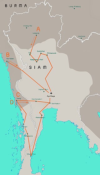
The Tavoy campaign of 1788 was a conflict between the Kingdom of Burma under Konbaung dynasty and the Kingdom of Siam under the Chakri dynasty over the town of Tavoy and the Tenasserim Coast.

References

  1. 1 2 Google (29 May 2023). "Tanintharyi" (Map). Google Maps . Google. Retrieved 29 May 2023.
  2. Microsoft; Nokia (29 May 2023). "Tanintharyi" (Map). Bing Maps . Microsoft. Retrieved 29 May 2023.
  3. 1 2 3 Bay of Bengal pilot: Bay of Bengal and the coasts of India and Siam, including the Nicobar and Andaman islands. USHydro. United States Hydrographic Office. 1916. p. 418. Retrieved November 15, 2010.
  4. 1 2 3 Reid, Robert; Grosberg, Michael (2005). Myanmar (Burma). Lonely Planet. pp. 162–163. ISBN   1-74059-695-1 . Retrieved 2010-11-15.
  5. 1 2 3 4 Eur (2002). "Physical and Social Geography". Far East and Australasia 2003. Psychology Press. p. 859. ISBN   1-85743-133-2.
  6. Minahan, James (2002). "Tavoyans". Encyclopedia of the Stateless Nations: S-Z. Greenwood Publishing Group. p. 1863. ISBN   0-313-32384-4.
  7. Anderson, pp. 11–12
  8. Anderson, p. 11-12
  9. 1 2 Anderson, John (1890). English intercourse with Siam in the seventeenth century. K. Paul, Trench, Trübner, & co., ltd. p.  5.
  10. 1 2 3 "South Tenasserim and the Mergui Archipelago". Scottish Geographical Magazine. Royal Scottish Geographical Society. 14: 453–454. 1898.
  11. Hunter, Sir William Wilson (1881). The imperial gazetteer of India. Vol. 9. Trübner & Co. p. 25.