Tarfala research station

Last updated

Tarfala research station Tarfala research station.jpg
Tarfala research station

The Tarfala research station (Swedish : Tarfala forskningstation) is a field station of Stockholm University. The station is situated in the Tarfala Valley in northern Sweden. It specializes in glacial, periglacial and climatological research.

Contents

It was here at Storglaciären that the first glacier mass balance program was initiated immediately after World War II. This glaciological program is continued to present day and thus constitutes the longest continuous study of this type in the world. In 1976, the first systematic studies on mountain permafrost in Scandinavia were started using Tarfala research station as main research base. Several years of field measurements proved, that Tarfala research station is located in a zone of widespread discontinuous permafrost. Today, Tarfala research station is a well known research place for studies on glaciers, mountain climate, periglacial geomorphology and alpine vegetation.

Geography

The station is situated in the Tarfala Valley in Swedish Lapland at an elevation of 1135 meters, and about 150 kilometres north of the Arctic Circle. The station is ideally located at the foot of Kebnekaise, the highest mountain in Sweden. The station is surrounded by several glaciers. The largest are Storglaciären, Isfallsglaciären, Kebnepakteglaciären and Tarfalaglaciären. [1]

Tarfala research station

Hans Wilhelmsson Ahlmann, a well-known Swedish geographer and glaciologist, was a leading personality with expeditions to Svalbard, Iceland and Greenland already in the 1930s. After World War II, he suggested regular studies also of the glaciers in the Kebnekaise area. Valter Schytt and other glaciologists proposed Storglaciären at Tarfala as ideal location for long-term glacier mass balance studies. Regular glaciological measurements started already in 1946, with a gauging station downstream of Storglaciären. [2]

Valter Schytt remained the leading personality and promoted the development of the research station until his death in 1985. [3] The number of station buildings gradually increased and annual university courses at Tarfala Research Station could start in 1959. Tarfala Research station was officially opened as a research station of Stockholms University in 1961 and expanded by four buildings through a grant from the Wallenberg Foundation. A sauna, a laboratory, a lecture hall and additional living quarters were added in the following years. Winter storm destroyed some buildings in 1975, 1985 and 1993; spring slush avalanches damaged the laboratory hut in 1982 and again in 1991. The damaged buildings were repaired or reconstructed during the following summers.

Research was focused on glaciology, hydrology and climate. The good location inmidst of glaciers and lakes, and the increasingly good infrastructure of the research station attracted scientists from other Swedish universities. The long-term station director Valter Schytt always welcomed scientists and students from abroad, too. In 1985, Valter Schytt passed away in Tarfala valley during a winter visit. In 1995/96, fifty years of research activities in Tarfala were celebrated and Per Holmlund is appointed as director for Tarfala Research Station.

Climate and Climate change

Climate

Systematic climatological measurements at Tarfala station exist since 1961 and are continued till today. [ when? ]

Climate data for Tarfala 1991–2020 (1144 m)
MonthJanFebMarAprMayJunJulAugSepOctNovDecYear
Record high °C (°F)8.2
(46.8)
6.0
(42.8)
9.1
(48.4)
10.8
(51.4)
15.7
(60.3)
18.8
(65.8)
23.6
(74.5)
21.2
(70.2)
17.7
(63.9)
13.7
(56.7)
10.3
(50.5)
8.0
(46.4)
23.6
(74.5)
Mean daily maximum °C (°F)−6.8
(19.8)
−7.2
(19.0)
−6.3
(20.7)
−2.5
(27.5)
1.9
(35.4)
6.9
(44.4)
11.2
(52.2)
9.5
(49.1)
5.0
(41.0)
−0.6
(30.9)
−3.5
(25.7)
−5.5
(22.1)
0.2
(32.3)
Daily mean °C (°F)−10.2
(13.6)
−10.5
(13.1)
−9.2
(15.4)
−6.0
(21.2)
−1.3
(29.7)
3.8
(38.8)
8.0
(46.4)
6.7
(44.1)
2.3
(36.1)
−3.3
(26.1)
−6.7
(19.9)
−8.7
(16.3)
−2.9
(26.7)
Mean daily minimum °C (°F)−14.0
(6.8)
−14.3
(6.3)
−12.9
(8.8)
−9.5
(14.9)
−4.4
(24.1)
1.0
(33.8)
4.9
(40.8)
4.3
(39.7)
0.2
(32.4)
−5.9
(21.4)
−10.0
(14.0)
−12.2
(10.0)
−6.1
(21.1)
Record low °C (°F)−31.9
(−25.4)
−32.8
(−27.0)
−25.0
(−13.0)
−20.7
(−5.3)
−18.4
(−1.1)
−9.2
(15.4)
−2.8
(27.0)
−5.2
(22.6)
−11.0
(12.2)
−19.0
(−2.2)
−25.0
(−13.0)
−25.4
(−13.7)
−32.8
(−27.0)
Source 1: SMHI [4]
Source 2: NOAA [5]
Climate data for Tarfala, 1961–2011
MonthJanFebMarAprMayJunJulAugSepOctNovDecYear
Mean daily maximum °C (°F)−8.3
(17.1)
−8.0
(17.6)
−7.5
(18.5)
−3.9
(25.0)
1.1
(34.0)
6.5
(43.7)
9.9
(49.8)
8.5
(47.3)
3.8
(38.8)
−1.4
(29.5)
−5.4
(22.3)
−7.4
(18.7)
−1.0
(30.2)
Daily mean °C (°F)−11.8
(10.8)
−11.3
(11.7)
−10.6
(12.9)
−7.5
(18.5)
−1.9
(28.6)
3.2
(37.8)
6.4
(43.5)
5.3
(41.5)
0.8
(33.4)
−3.9
(25.0)
−7.9
(17.8)
−10.7
(12.7)
−4.6
(23.7)
Mean daily minimum °C (°F)−15.3
(4.5)
−14.6
(5.7)
−13.7
(7.3)
−11.1
(12.0)
−5.0
(23.0)
−0.1
(31.8)
2.9
(37.2)
2.1
(35.8)
−2.2
(28.0)
−6.4
(20.5)
−10.3
(13.5)
−14.0
(6.8)
−8.2
(17.2)
Source: [6]

The valley is sometimes hit by katabatic winds, which can generate very high wind speeds. The Swedish record of measured wind speed is from Tarfala research station with 81 m/s (290 km/h) on 20 December 1992.

Glaciology and climate change

The mass balance of a glacier is the difference between accumulation and ablation (sublimation and melting). A glacier with a sustained negative balance is out of equilibrium and will retreat, while one with a sustained positive balance is out of equilibrium and will advance. The determination of the mass balance requires time consuming field work. The winter mass balance is taken in the end of winter by measuring and probing snowpack depth in snow pits at the accumulation zone. Thus the past winters residual snowpack is analysed by its depth and density. In the ablation zone, ablation measurements are made using stakes inserted vertically into the glacier, usually at the end of the previous melt season. At the end of the melt (ablation) season, the length of stake exposed by melting ice is measured. Most stakes must be replaced each year. Mass balance results have been regularly published by Schytt [7] and Holmlund. [8]

The climate in the Tarfala valley is quite continental, compared with the regions west of the Kebnekaise; the climate in western Norway is maritime. This steep climatic gradient influences also both the net balance gradients on glaciers and the glaciation level. The average annual precipitation is about 1000 mm at Tarfala Research Station. This is less than half of the precipitation in the Norwegian mountains to the west. The mean annual air temperature at the equilibrium line at about 1500 m a.s.l. is about -6 °C.

Regular glaciological measurements at Storglaciären were started in 1946. [2] In 1968, a new gauging station was built, and the International Hydrological Decade (IHD) spawned its hydrological activities also in the Tarfala valley. Today, the glacier mass balance program at Storglaciären is globally known as one of the most important glaciological records and supplies important data to climate change questions in subarctic mountain regions. [9] [10] [11]

Permafrost and climate change

Altitudinal zonation of mountain permafrost for Tarfala (Kebnekaise) and Jotunheimen (Norway) with corresponding mean annual air temperatures (MAAT) Alpine permafrost in Scandinavia 01.jpg
Altitudinal zonation of mountain permafrost for Tarfala (Kebnekaise) and Jotunheimen (Norway) with corresponding mean annual air temperatures (MAAT)

Whereas permafrost occurrences in palsa bogs were well known already in the beginning of the 20th century [12] and many permafrost studies were done on Spitzbergen, it was doubted until the early 1980s that mountain permafrost is present in the Scandinavian mountains. Its widespread existence at Tarfala could be proved in 1976 with refraction seismic soundings. It was demonstrated clearly, that Tarfala valley belongs to the region of discontinuous mountain permafrost. The active layer thickness on protalus ramparts and other wind exposed ridges was up to two meters. [13] Four years of systematic permafrost research in the Tarfala valley followed during the years 1977 till 1980, applying different geophysical methods (seismic and DC-geoelectrical soundings in summer, continuous measurements of the ground temperatures in boreholes to get the mean annual ground temperature). In March 1980, measurement of the basal temperature of the snow cover [14] and snow distribution were used to secure the findings. The field studies allowed to sketch a reliable picture of the permafrost distribution in the Kebnekaise region. Detailed results were published in 1982 and later on. [15]

The studies were enlarged to the areas north of Tarfala (Abisko region, Lyngen Peninsula in Norway). Additional studies covered the mountain ranges in the south of the Scandinavian mountain range (Jotunheimen, Rondane, Dovre). The resulting habilitation thesis was dedicated to the memory of Valter Schytt. [16] A summary of the results was printed in Geografiska Annaler. [17] Thus, Tarfala station is located inmidst of the discontinuous permafrost zone, with a MAAT of −3.5 °C (25.7 °F) at an elevation of 1,130 metres (3,710 ft). At 1,600 metres (5,200 ft) above sea level, the continuous permafrost zone will be reached.

Within the EU-sponsored project PACE (Permafrost and Climate in Europe), two boreholes in bedrock, 100 m and 15 m deep were drilled in March 2000. [18] The location is above the research station at an altitude of 1540 meters and near Tarfalaglaciären. The thermistor chain in the 100 m hole includes 30 thermistors. The depth of the Zero Annual Amplitude (ZAA) is 15 to 20 meters with a temperature of -3.2 °C in the year 2000. The ground temperature at a depth of 100 meters is -2.75 °C. The geothermal gradient of 1.17 °C /100 m allows to extrapolate a permafrost thickness of 330 meters, and thus confirms suggestions done with the results of earlier geoelectric soundings. [19]

Warming trend of the air temperatures due to climate change is reflected also in the ground temperatures. The geothermal gradient in the uppermost 50 meters hint to a significant temperature increase during at least 50 years. [20]

Related Research Articles

<span class="mw-page-title-main">Geography of Sweden</span> Overview of the geography of Sweden

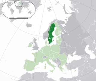
Sweden is a country in Northern Europe on the Scandinavian Peninsula. It borders Norway to the west; Finland to the northeast; and the Baltic Sea and Gulf of Bothnia to the south and east. At 450,295 km2 (173,860 sq mi), Sweden is the largest country in Northern Europe, the fifth largest in Europe, and the 55th largest country in the world.

<span class="mw-page-title-main">Glaciology</span> Scientific study of ice and natural phenomena involving ice

Glaciology is the scientific study of glaciers, or, more generally, ice and natural phenomena that involve ice.

<span class="mw-page-title-main">Kebnekaise</span> Swedens highest mountain

Kebnekaise is the highest mountain in Sweden. The Kebnekaise massif, which is part of the Scandinavian mountain range, has two main peaks. The glaciated southern peak used to be the highest at 2,120 metres (6,960 ft) above sea level, but has shrunk by 24 meters during the last 50 years, making the northern icefree peak at 2,096.8 metres (6,879 ft) the highest. Kebnekaise lies in Swedish Lapland, about 150 kilometres (93 mi) north of the Arctic Circle and west of Kiruna near the Kungsleden hiking trail between Abisko and Hemavan.

<span class="mw-page-title-main">Utsjoki</span> Municipality in Lapland, Finland

Utsjoki is a municipality in Finland, the northernmost in the country. It is in Lapland and borders Norway as well as the municipality of Inari. The municipality was founded in 1876. It has a population of 1,139 (31 December 2023) and covers an area of 5,372.00 square kilometres (2,074.14 sq mi) of which 227.51 km2 (87.84 sq mi) is water. The population density is 0.22 inhabitants per square kilometre (0.57/sq mi).

<span class="mw-page-title-main">Jotunheimen</span> Mountain range in Norway

Jotunheimen is a mountainous area of roughly 3,500 square kilometres (1,400 sq mi) in southern Norway and is part of the long range known as the Scandinavian Mountains. The 29 highest mountains in Norway are all located in the Jotunheimen mountains, including the 2,469-metre (8,100 ft) tall mountain Galdhøpiggen. The Jotunheimen mountains straddle the border between Innlandet and Vestland counties.

<span class="mw-page-title-main">Sarek National Park</span> National park in Sweden

Sarek National Park is a national park in Jokkmokk Municipality, Lapland in northern Sweden. Established in 1909, the park is among the oldest national parks in Europe. It is adjacent to two other national parks, namely Stora Sjöfallet and Padjelanta. The shape of Sarek National Park is roughly circular with an average diameter of about 50 km (31.07 mi).

<span class="mw-page-title-main">Rock glacier</span> Glacial landform

Rock glaciers are distinctive geomorphological landforms, consisting either of angular rock debris frozen in interstitial ice, former "true" glaciers overlain by a layer of talus, or something in-between. Rock glaciers are normally found at high latitudes and/or elevations, and may extend outward and downslope from talus cones, glaciers or terminal moraines of glaciers.

<span class="mw-page-title-main">Glacier mass balance</span> Difference between accumulation and melting on a glacier

Crucial to the survival of a glacier is its mass balance of which surface mass balance (SMB), the difference between accumulation and ablation. Climate change may cause variations in both temperature and snowfall, causing changes in the surface mass balance. Changes in mass balance control a glacier's long-term behavior and are the most sensitive climate indicators on a glacier. From 1980 to 2012 the mean cumulative mass loss of glaciers reporting mass balance to the World Glacier Monitoring Service is −16 m. This includes 23 consecutive years of negative mass balances.

<span class="mw-page-title-main">International Permafrost Association</span>

The International Permafrost Association (IPA), founded in 1983, is an international professional body formed to foster the dissemination of knowledge concerning permafrost and to promote cooperation among individuals and national or international organisations engaged in scientific investigation and engineering work related to permafrost and seasonally frozen ground. The IPA became an Affiliated Organisation of the International Union of Geological Sciences in July 1989.

<span class="mw-page-title-main">Abisko Scientific Research Station</span> Research station in Sweden

The Abisko Scientific Research Station (ANS) is a field research station managed by the Swedish Polar Research Secretariat. Situated on the south shore of Lake Torneträsk, it lies at the edge of the Abisko National Park. The station conducts ecological, geological, geomorphological and meteorological research in subarctic environments and each year about 500 scientists visit from all over the world. The varied geological, topographical and climatic conditions of the area allow it to be inhabited by a range of flora and fauna. These features, which have caused the area to be given National Park status, also make it an important place for scientific research, particularly of alpine and subalpine ecosystems.

<span class="mw-page-title-main">Kebnekaise mountain lodge</span>

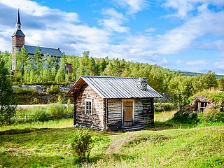
Kebnekaise mountain lodge, elevation 690 metres (2,260 ft), is situated at the base of Mount Kebnekaise, 19 kilometres (12 mi) west of Nikkaluokta, which in turn is situated 66 kilometres (41 mi) west of Kiruna in Lappland, Sweden. The lodge is owned and managed by the Swedish Tourist Association (STF).

Mark Dyurgerov was an internationally known glaciologist and Fellow of the Institute of Arctic and Alpine Research (INSTAAR) of the University of Colorado at Boulder. He was born in Moscow, Russia; both of his parents were engineers, and his mother was also a Russian poet.

<span class="mw-page-title-main">Blockfield</span>

A blockfield, felsenmeer, boulder field or stone field is a surface covered by boulder- or block-sized rocks usually associated with a history of volcanic activity, alpine and subpolar climates and periglaciation. Blockfields differ from screes and talus slope in that blockfields do not apparently originate from mass wastings. They are believed to be formed by frost weathering below the surface. An alternative theory that modern blockfields may have originated from chemical weathering that occurred in the Neogene when the climate was relatively warmer. Following this thought the blockfields would then have been reworked by periglacial action.

<span class="mw-page-title-main">Tarfala Valley</span>

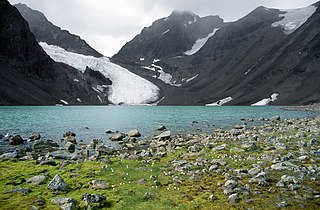
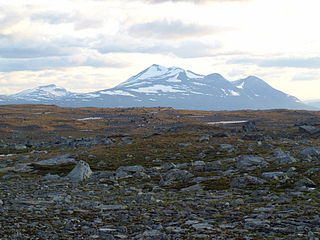
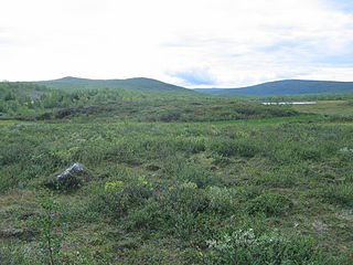
Tarfala Valley is a valley in Kiruna Municipality, Sweden. Several glaciers flow into the valley and glaciological research has been conducted since 1946 at the Tarfala scientific station.

Juvvasshøi or Juvvasshøe is a mountain in Lom Municipality in Innlandet county, Norway. The 1,893-metre (6,211 ft) tall mountain is located in the Jotunheimen mountains just outside the border of Jotunheimen National Park. The mountain sits about 20 kilometres (12 mi) southwest of the village of Fossbergom and about 50 kilometres (31 mi) northeast of the village of Øvre Årdal. The mountain is surrounded by several other notable mountains including Store Lauvhøi to the northeast, Glittertinden to the east, Galdhøi and Galdhøpiggen to the southwest, and Storhøi to the northwest.

<span class="mw-page-title-main">Storglaciären</span>

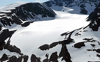
Storglaciären is a glacier in Tarfala Valley in the Scandinavian Alps of Kiruna Municipality, Sweden. The glacier is classified as polythermal having both cold and warm bottom temperatures. It was on Storglaciären that the first glacier mass balance research program began, which continues to the present day; this is the longest continuous study of its type in the world. Storglaciären has had a cumulative negative mass balance of -17 m between 1946 and 2006. The program began monitoring the Rabots Glaciär in 1982, Riukojietna in 1985, and Mårmaglaciären in 1988. All three of these glaciers have had a strong negative mass balance since monitoring began.

<span class="mw-page-title-main">Scandinavian Mountains</span> Mountain range in Finland, Norway and Sweden

The Scandinavian Mountains or the Scandes is a mountain range that runs through the Scandinavian Peninsula. The western sides of the mountains drop precipitously into the North Sea and Norwegian Sea, forming the fjords of Norway, whereas to the northeast they gradually curve towards Finland. To the north they form the border between Norway and Sweden, reaching 2,000 metres (6,600 ft) high at the Arctic Circle. The mountain range just touches northwesternmost Finland but are scarcely more than hills at their northernmost extension at the North Cape.

<span class="mw-page-title-main">Matti Seppälä</span> Finnish geomorphologist (1941–2020)

Matti Kullervo Seppälä was a Finnish geomorphologist specialized in cold climate aeolian processes.

Stig Valter Schytt was a Swedish glaciologist.

PTAAGMB

References

  1. Holmlund, Per (15 January 2007). "Tarfala in numbers". Department of Physical Geography and Quaternary Geology. Archived from the original on 4 March 2016. Retrieved 21 March 2012.
  2. 1 2 Hagström, Mirja D (10 December 2008). "A Brief Tarfala Chronology". Department of Physical Geography and Quaternary Geology. Archived from the original on 18 April 2013. Retrieved 21 March 2012.
  3. Swithinbank, Charles; Robin, Gordon (1985). "Valter Schytt 1920–1985". Journal of Glaciology. 31 (109): 375–376. doi: 10.3189/S0022143000006754 . S2CID   230098335.
  4. "SMHI 1991-2020 Normals". SMHI.
  5. "NOAA / WMO averages 1991-2020 Tarfala". SMHI / NOAA. Retrieved 25 August 2023.
  6. "SMHI". Archived from the original on 13 February 2013.
  7. Schytt, Valter (1981). "The Net Mass Balance of Storglaciären, Kebnekaise, Sweden, Related to the Height of the Equilibrium Line and to the Height of the 500 mb Surface". Geografiska Annaler. 63A (3/4): 219–223.
  8. Holmlund, Per (1987). "Mass Balance of Storglaciären during the 20th Century". Geografiska Annaler. 69A (3): 439–447.
  9. Holmlund, Per; Karlén, W.; Grudd, H. (1996). "Fifty years of mass balance and glacier front observations at the Tarfala research station". Geografiska Annaler. 78A (2/3): 105–114.
  10. Holmlund, Per; Jansson, Peter; Pettersson, Rickard (2005). "A re-analysis of the 58-year mass balance record of Storglaciären, Sweden". Annals of Glaciology. 42: 389–394.
  11. Holmlund, Erik S.; Holmlund, Per (2019). "Constraining 135 years of mass balance with historic structure-from-motion photogrammetry on Storglaciären, Sweden". Geografiska Annaler. 101A (3): 195–210.
  12. Hamberg, A. (1904). "Till frågan om förekomsten af alltid frozen mark I Sverige". Ymer (in Swedish). 24: 87–93.
  13. King, Lorenz (1977). "Permafrostuntersuchungen in Tarfala (Schwedisch Lappland) mit Hilfe der Hammerschlagseismik". Zeitschrift für Gletscherkunde und Glazialgeologie (in German). 12 (2): 187–204.
  14. Haeberli, Wilfried (1973). "Die Basis-Temperatur der winterlichen Schneedecke als möglicher Indikator für die Verbreitung von Permafrost in den Alpen". Zeitschrift für Gletscherkunde und Glazialgeologie (in German). IX (1–2): 221–227.
  15. King, Lorenz (1983). "High Mountain Permafrost in Scandinavia". Permafrost: Fourth International Conference, Proceedings: 612–617.
  16. King, Lorenz (1984). "Permafrost in Skandinavien - Untersuchungsergebnisse aus Lappland, Jotunheimen und Dovre/Rondane". Heidelberger Geographische Arbeiten (in German). 76: 174 pages.
  17. King, Lorenz (1986). "Zonation and ecology of high mountain permafrost in Scandinavia". Geografiska Annaler. 68A (3): 131–139.
  18. Harris, Charles; Haeberli, Wilfried; Vonder Mühll, Daniel; King, Lorenz (2001). "Permafrost Monitoring in the High Mountains of Europe: the PACE Project in its Global Context". Permafrost and Periglacial Processes. 12 (1): 3–11. doi:10.1002/ppp.377.
  19. King, Lorenz (1982). "Qualitative und quantitative Erfassung von Permafrost in Tarfala (Schwedisch-Lappland) und Jotunheimen (Norwegen) mit Hilfe geoelektrischer Sondierungen". Zeitschrift für Geomorphologie (in German). Suppl.-Band (43): 139–160.
  20. Jonsell, Ulf Y.; Hock, Regine; Duguay, Martial (2013). "Recent air and ground temperature increases at Tarfala Research Station, Sweden". Polar Research. 32: 10 pages. doi: 10.3402/polar.v32i0.19807 .
Measurements of the basal temperature of the snow cover end of winter. Several hundred measurements give an indication to probable permafrost sites, Tarfala, Kebnekaise. Alpine permafrost in Scandinavia 17.jpg
Measurements of the basal temperature of the snow cover end of winter. Several hundred measurements give an indication to probable permafrost sites, Tarfala, Kebnekaise.
Soil temperature recordings, refraction seismic and DC-geoelectric soundings confirm that Tarfala area shows widespread permafrost occurrences above 1100 m a.s.l. Alpine permafrost in Scandinavia 07.jpg
Soil temperature recordings, refraction seismic and DC-geoelectric soundings confirm that Tarfala area shows widespread permafrost occurrences above 1100 m a.s.l.
Isotherm map of Lapland showing a strong maritime/continental contrast from west to east. A MAAT of +2 degC (reduced to sea level altitude) corresponds to a MAAT of about -4 degC at 1200 m a.s.l., a region where permafrost patches may be expected in all favored, wind exposed sites. In areas above 1600 meters and at a MAAT of -6 degC continuous permafrost probably exists (King, 1984). Alpine permafrost in Scandinavia 04.jpg
Isotherm map of Lapland showing a strong maritime/continental contrast from west to east. A MAAT of +2 °C (reduced to sea level altitude) corresponds to a MAAT of about -4 °C at 1200 m a.s.l., a region where permafrost patches may be expected in all favored, wind exposed sites. In areas above 1600 meters and at a MAAT of -6 °C continuous permafrost probably exists (King, 1984).

67°54′40″N18°36′40″E / 67.91111°N 18.61111°E / 67.91111; 18.61111