Bamba is a small town and rural commune in the Bourem Cercle of the Gao Region of Mali. The town is located on the left (north) bank of the Niger River, 190 km east of Timbuktu and 230 km northwest of the town of Gao. In the 2009 census the commune had a population of 28,524.

Timbuktu Cercle is an administrative subdivision of the Tombouctou Region of Mali. It is the largest cercle by area in the whole of Mali. The capital lies at the city of Timbuktu. The cercle is divided into Rural and Urban Communes, and below this, quarters/villages. In the 2009 census the cercle had a population of 124,546.

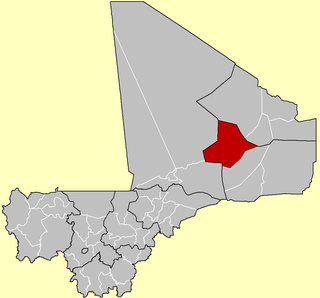
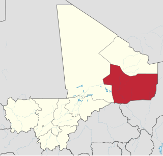
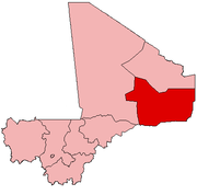
Gao Cercle is an administrative subdivision of the Gao Region of north-eastern Mali. The administrative center (chef-lieu) is the town of Gao.

Kadiolo is a town, rural commune and seat of the Kadiolo Cercle in the Sikasso Region of southern Mali. The town lies 85 km south of Sikasso, 13 km north of the border with the Ivory Coast and 30 km west of the border with Burkino Faso. The commune of Kadiolo covers an area of 783 square kilometers and includes the town and 19 villages. In the 2009 census it had a population of 59,932.
Farakala is a village and commune in the Cercle of Sikasso in the Sikasso Region of southern Mali. The commune covers an area of 280 square kilometers (110 sq mi) and includes 11 villages. In the 2009 census it had a population of 7,960. The village of Farakala lies 40 km (25 mi) west of Sikasso on the RN7 highway linking Sikasso and Bougouni.
Diomaténé is a village and rural commune in the Cercle of Sikasso in the Sikasso Region of southern Mali. The commune covers an area of 96 square kilometers and includes four villages. In the 2009 census it had a population of 4,274. The village of Diomaténé, the chef-lieu of the commune, is 11 km north of Sikasso.
Anefif or Anéfis is a Saharan village and commune in the Cercle of Kidal in the Kidal Region of north-eastern Mali. The village lies 95 km (59 mi) southwest of Kidal on the route linking Kidal to Bourem and Gao. In 2009 the commune had a population of 5,087.
Bara is a rural commune and village in the Cercle of Ansongo in the Gao Region of south-eastern Mali.
Talataye is a village and rural commune in the Cercle of Ansongo in the Gao Region of south-eastern Mali. The commune has an area of approximately 8,126 square kilometers. In the 2009 census it had a population of 13,907.
Taboye is a rural commune and village in the Cercle of Bourem in the Gao Region of south-eastern Mali. The commune is crossed by the River Niger and includes the villages of Bia, Dagha, Ha, Moudakane, Ouani, Tondibi and Taboye. In the 2009 census the commune had a population of 20,503.
Bourra is a commune in the Cercle of Ansongo in the Gao Region of south-eastern Mali. The commune extends along the left (east) bank of the River Niger. It covers an area of approximately 2,323 square kilometers and includes 14 villages. In the 2009 census the commune had a population of 19,163. The main village (chef-lieu) is Tassiga.
Gabero is a rural commune in the Cercle of Gao in the Gao Region of south-eastern Mali. The commune covers an area of approximately 2,007 square kilometers and includes 15 villages. In the 2009 census the commune had a population of 25,688. The Niger River crosses the commune from north to south. The administrative center (chef-lieu) is Haoussa Foulane that lies on the left (east) bank of the Niger. The village is 45 km south of Gao, on the road, the N17, linking Gao and Ansongo.
Gounzoureye is a rural commune in the Cercle of Gao in the Gao Region of south-eastern Mali. The commune includes the villages of Koima, Tchirissoro, Sadou, Lobou, Sidibé, Kosseye, Gorom Gorom, Kadji, Wabaria, Arhabou, Tacharane, Bagoundjé I and Bagoundjé II, which are all located on the banks of the River Niger. The administrative center (chef-lieu) is at the village of Wabaria. In the 2009 census the commune had a population of 30,772.
N'Tillit is a rural commune and village in the Cercle of Gao in the Gao Region of south-eastern Mali. In the 2009 census the commune had a population of 22,100.
Sony Aliber or Soni Ali Ber is a commune in the Cercle of Gao in the Gao Region of south-eastern Mali. The main villages are: Bagnadji, Batal, Berrah, Forgho Arma, Forgho Songhai, Kochakarey, Kokorom, Magnadoué, Seina and Zindiga. The administrative center (Chef-lieu) is the village of Forgo Sourhai which is located 25 km north of Gao. The commune includes the banks of the River Niger for a distance of around 35 km. In the 2009 census the commune had a population of 44,099.
Dogofry is a village and a rural commune in the Cercle of Niona in the Ségou Region of southern-central Mali. The commune covers an area of approximately 3,820 square kilometers and is bordered to the north by the Republic of Mauritania, to the east by the commune of Nampalari, to the southeast by the commune of Diabaly, to the southwest by the commune of Sokolo and to the west by the commune of Guiré in the Cercle of Nara. It includes 19 villages, and had a population of 34,057 in the 2009 census. The south of the commune includes a region irrigated as part of the Office du Niger scheme. The village of Dogofry lies in this irrigated area, about 60 km north of Niono, to the west of the Fala de Molodo and the Distributeur de Kogoni.
Dallah is a village and rural commune in the Cercle of Douentza in the Mopti Region of Mali. The village is located close to the southern edge of the Gandamia Massif, an inselberg that rises 750 m above the plain. The massif extends for 60 km in an east-west direction and 10 km north to south. The metalled road, the RN16, that run between Mopti and Gao passes to the south of the village. The commune contains 12 villages and in the 2009 census had a population of 8,504.
Bourem Sidi Amar is a village and commune of the Cercle of Diré in the Tombouctou Region of Mali.