Tasman Bridge disaster

Last updated

Tasman Bridge disaster
View of the Tasman Bridge from Kalatie Road Montague Bay looking toward the Powder Jetty over Cuthbertson's Boat shed (1975) (16200189861).jpg
Tasman Bridge from east following collision, 1975
Date5 January 1975 (1975-01-05)
Time9:27 p.m. (AEDT)
Location Hobart, Tasmania, Australia
Coordinates 42°51′53″S147°20′48″E / 42.86472°S 147.34667°E / -42.86472; 147.34667
TypeAccident
CauseBulk carrier Lake Illawarra collision with a bridge pier
Deaths12
View of the bridge as it stood in 2006 Tasman Bridge.jpg
View of the bridge as it stood in 2006

The Tasman Bridge disaster occurred on the evening of 5 January 1975, in Hobart, the capital city of Australia's island state of Tasmania, when the bulk carrier Lake Illawarra , travelling up the Derwent River, collided with several pylons of the Tasman Bridge and caused a large section of the bridge deck to collapse onto the ship and into the river below. Twelve people were killed, including seven crew on board Lake Illawarra, and the five occupants of four cars which fell 45 metres (150 ft) after driving off the bridge. Hobart was cut off from its eastern suburbs, and the loss of the road connection had a major social impact. The ship's master was officially penalised for inattention and failure to handle his vessel in a seamanlike manner.

Contents

Collision and collapse

Model showing the scene on the bottom of the Derwent River TasmanBridgeDisaster3.PNG
Model showing the scene on the bottom of the Derwent River
TasmanBridgeDisaster1.PNG

The collision occurred at 9:27 p.m. Australian Eastern Daylight Time (UTC+11:00) on Sunday 5 January 1975. The bulk carrier Lake Illawarra , carrying 10,000 tonnes (11,000 short tons; 22,000,000 lb) of zinc ore concentrate, was heading up the Derwent River to offload its cargo to EZ Industries' Risdon Zinc Works, upstream from Hobart and about 3 km (1.9 mi) from the bridge. The 1,025 m (3,363 ft) long main viaduct of the bridge was composed of a central main navigation span, two flanking secondary navigation spans, and nineteen approach spans. The ship was off course as it neared the bridge, partly due to the strong tidal current but also because of inattention by the ship's master, Captain Boleslaw Pelc. [1] Initially approaching the bridge at eight knots (15 km/h; 9.2 mph), Pelc slowed the ship to a 'safe' speed. Although Lake Illawarra was capable of passing through the bridge's central navigation span, Pelc attempted to pass through one of the eastern spans.

Despite several changes of course, Lake Illawarra proved unmanageable due to having insufficient steerage way. In desperation Pelc ordered 'full speed astern', at which point all control was lost. The vessel drifted towards the bridge midway between the central navigation span and the eastern shore, colliding with the pile capping of piers 18 and 19, bringing three unsupported spans and a 127-metre (417 ft) section of roadway crashing into the river and onto the ship's deck. Lake Illawarra listed to starboard and sank within minutes a short distance to the south, in 35 metres (115 ft) of water. Seven crew members were trapped and drowned. The subsequent Court of Marine Inquiry found that Pelc had not handled the ship in a proper and seamanlike manner, and his certificate was suspended for six months. [2]

As the collision occurred on a Sunday evening, there was relatively little traffic on the bridge. While no cars were travelling between the 18th and 19th pylons when that section collapsed, four cars drove over the gap, killing five occupants. Two drivers managed to stop their vehicles at the edge, but not before their front wheels had dropped over the lip of the bridge deck. One of these cars contained Frank and Sylvia Manley in their Holden HQ Monaro.

Sylvia Manley: "As we approached, it was a foggy night ... there was no lights on the bridge at the time. We just thought there was an accident. We slowed down to about 40 km/h (25 mph) and I'm peering out the window, desperately looking to see the car ... what was happening on the bridge. We couldn't see anything but we kept on travelling. The next thing, I said to Frank, "The bridge is gone!" And he just applied the brakes and we just sat there swinging. [3] As we sat there, we couldn't see anything in the water. All we could see was a big whirlpool of water and apparently the boat was sinking. So with that, we undid the car door and I hopped out." [4]

Frank Manley: "[Sylvia] said "The white line, the white line's gone. Stop!" I just hit the brakes and I said "I can't, I can't, I can't stop." And next thing we just hung off the gap...when I swung the door open, I could see, more or less, see the water...and I just swung meself towards the back of the car and grabbed the headrest like that to pull myself around. [4] There's a big automatic transmission pan underneath [the car] – that's what it balanced on." [3]

The other car contained Murray Ling, his wife Helen and two of their children. They were driving over the bridge in the east-bound lanes when the span lights went out: 'I knew something bad must have happened so I slowed down'. Ling then noticed several cars ahead of him seemingly disappear as they drove straight over the edge, so he slammed his foot on the brakes. He stopped the car inches from the drop. A following car, caught unaware by the unexpected stop, drove into the rear of Ling's car, pushing its front wheels over the breach. He, too, eased himself and his young family out of the car, then stood horrified as two other cars ignored his attempts to wave them down, raced past (one of which actually swerved around to avoid him), and hurtled over the edge into the river. A loaded bus full of people swerved and skidded, slamming into the side railings after being waved down by Ling. [5]

Emergency response

Private citizens living nearby were on the scene early, even before Lake Illawarra had sunk. Three of these were Jack Read in his H28 yacht Mermerus; David Read in a small launch; and Jerry Chamberlain, who had their boats moored in Montagu Bay close by. These and others, and many shore-based residents, were responsible for saving many of the crew from Lake Illawarra. Those in small craft acted alone in very difficult circumstances with falling concrete, live wires, and water from a broken pipe above, until the water police arrived on the scene. A large number of other organisations were involved in the emergency response, including police, ambulance service, fire brigade, emergency management agency, marine board, Royal Hobart Hospital, the Hobart Tug Company, the Public Works Department, the Transport Commission, the HydroElectric Commission, the Hobart Regional Water Board, the Australian Army and the Royal Australian Navy. At 2:30 am, a fourteen-man Navy Clearance Diving Team flew to Hobart to assist water police in the recovery of the vehicles which had driven off the bridge. Two vehicles were identified on 7 January; one was salvaged that day and the second three days later. Another vehicle was found buried under rubble on 8 January.[ citation needed ]

A comprehensive survey of the wreck of Lake Illawarra was completed by 13 January. The divers operated in hazardous conditions, with little visibility and strong river currents, contending with bridge debris such as shattered concrete, reinforced steel rods, railings, pipes, lights, wire and power cables. Strong winds on the third day brought down debris from the bridge above, including power cables, endangering the divers working below. [6]

Victims

A total of twelve people died in the disaster: seven crew of Lake Illawarra and five motorists.

Impact

Geography of Hobart, showing the main part of the city on the west (green), and outer suburbs (blue) LGA Tas SE Hobart.png
Geography of Hobart, showing the main part of the city on the west (green), and outer suburbs (blue)

Isolation

The collapse of Tasman Bridge isolated two sides of the city which had heavily relied upon it for most daily activities. [9] 30% of Hobart's residents lived on the eastern shore and were effectively isolated. The day after the incident, as 30,000 residents set out for work, they found that the former three-minute commute over the bridge had turned into a 90-minute trip. [10]

People on the eastern shore quickly became isolated, as most schools, hospitals, businesses and government offices were located on the western shore. Prior to the disaster, many services on the eastern shore were severely lacking. [11] Access to medical services in particular posed problems for residents in the east, as services consisted only of local clinics. Hobart's hospitals—the Royal Hobart Hospital and the Calvary Hospital—were located on the western shore. What was previously a short drive across the river became a 50 km (31 mi) trip via the estuary's other bridge in Bridgewater. Most of Hobart's cultural activities, such as theatres, cinemas, the museum and art gallery, restaurants, meeting places, lecture theatres and the botanical gardens, were located on the western shore. [12]

Replacement ferries

Within an hour of the incident, the Sullivans Cove Ferry Company started services across the river, and continued its services throughout the night. Three private ferries were in place the next day while the Kosciusko, Lady Ferguson and Lady Wakehurst were loaned by the Public Transport Commission, Sydney. [13] [14] The MV Cartela, which operated excursions on the Derwent, was pressed into service as a cross-river ferry. [15]

Social effects

The disaster caused a variety of social and psychological difficulties. Although comparatively minor in loss of life and damage, it presented a problem beyond the capacity of the community to resolve. [10] The disaster had unique characteristics and occurred at a time when the effects of disasters on communities were not well understood. "Opportunities for the community to be involved in the response to the disaster and the physical restoration of infrastructure were minimal because of the nature of the event. It is likely that this lack of community involvement contributed to the enduring nature of the effects of the disaster on a number of individuals." [12]

A study of police data found that in the six months after the disaster, crime rose 41% on the eastern shore, while the rate on the city's western side fell. Car theft rose almost 50% in the isolated community, and neighbourhood quarrels and complaints rose 300%. [10] Frustration and anger was directed towards the transport services. Visible progress on restoration of the bridge was slow because of the need for extensive underwater surveys of debris and the time required for design of the rebuilding. "The ferry queues did however provide some assistance by providing a forum where people with much in common could vent their frustration." [12] A sociological study described how the physical isolation led to debonding (the setting aside of bonds that constitute the fabric of normal social life). The loss of the Tasman Bridge in Hobart disconnected two parts of the city and had far-reaching effects on the people separated. [16]

The disaster was a major contributor to ferry services being the lifeline for people needing to cross the river for daily work. Bob Clifford was the major operator of ferries at the time, and quickly built more of his small aluminium craft, using his company Sullivans Cove Ferry Company. He later went on to become the major Tasmanian shipbuilder with a firm which continues today, called Incat. [17]

Rebuilding

Repairing the bridge

View from the eastern shore showing the rebuilt pylon #18. Pylon #19 was not rebuilt. TasmanBridge2002.PNG
View from the eastern shore showing the rebuilt pylon #18. Pylon #19 was not rebuilt.

In March 1975, a Joint Tasman Bridge Restoration Commission was appointed to restore the Tasman Bridge. The Federal Government agreed to fund the project, which began in October that year. The reconstruction included modification of the whole bridge to accommodate an extra traffic lane, allowing for a peak period 'tidal flow' system of three lanes for major flow and two for the minor flow. Approximately one year after the bridge collapse, a temporary two lane Bailey bridge 788 m (2,585 ft) long, linking the eastern and western shores of the Derwent, was opened. [11]

Specialists in marine engineering undertook an extensive investigation to locate bridge debris. This survey took several months to complete, and parts of the bridge weighing up to 500 tonnes (550 short tons; 1,100,000 lb) were accurately located using equipment developed by the University of Tasmania and the Public Works Department. Maunsell and Partners were appointed consultants for the rebuilding project. The firm John Holland was awarded the construction contract. [18] Engineers decided not to replace pier 19 as there was too much debris on the site. [19] The Tasman Bridge was re-opened on 8 October 1977, nearly three years after its collapse. [1] The annual expenditures on the Tasman Bridge reconstruction were $1.7 m in 1974–75; $12.3 m in 1975–76; $13.2 m in 1976–77 and $6.1m in 1977–78. [20]

The engineering design of the Tasman Bridge provided impact absorbing fendering to the pile caps of the main navigation span capable of withstanding a glancing collision by a large ship, but all other piers were unprotected. This disaster shares some common features with the Skyway Bridge collapse in Florida in 1980, the I-40 bridge disaster in Oklahoma in 2002, and the Francis Scott Key Bridge collapse in Baltimore in 2024, all three involving collisions with ships. When river traffic "comprises large vessels, even at low speed, the consequences of pier failure can be catastrophic". [21] In the field of structural engineering, the concept of ‘pier-redundant’ bridges refers to a bridge superstructure which does not collapse when a single pier is removed. [21] Two ‘pier-redundant’ bridges have been constructed in Australia – over the Murray River at Berri and at Hindmarsh Island in South Australia. The probability of ship impact is now regularly evaluated by specialist consultants when designing major bridges. One solution is to protect bridge piers through strengthening or the construction of impact-resistant barriers. [22]

The disaster resulted in changes to the regulations pertaining to shipping movements on the Derwent River. In 1987, a system of sensors measuring river currents, tidal height, and wind speed was installed near the bridge to provide data for ship movements in the area. [23] The Marine and Safety (Pilotage and Navigation) Regulations (2007) contains specific provisions dealing with the Bridge, e.g.:

"The master of a vessel approaching the Bridge to navigate it through a span must (a) have the vessel fully under control; and (b) navigate the vessel with all possible care at the minimum speed required to pass safely under the bridge". [24]

Vessels above a certain size are required to be piloted, and vehicle movements on the bridge are temporarily halted when large vessels are to pass underneath the bridge. As an added precaution, it is now mandatory for most large vessels to have a tug in attendance as they transit the bridge in the event that assistance with steerage may be required.

Development on the eastern shore

2005 panorama of Hobart illustrating the extent of the city's reliance on the Tasman Bridge Hobart from Mt Wellington (cropped).jpg
2005 panorama of Hobart illustrating the extent of the city's reliance on the Tasman Bridge

The disaster stimulated development in Kingborough, a municipality south of Hobart on the western shore, because of the reduced travel times for western shore workers compared to the eastern shore. The eastern shore eventually became a more self-contained community, with a higher level of employment and improved services and amenities, than had been the case prior to the disaster. The previous imbalance between facilities and employment opportunities was redressed as a result of the disaster. [12]

A new bridge crossing the river, the Bowen Bridge, was completed in 1984, a few kilometres north of the Tasman Bridge.[ citation needed ]

Memorial

A plaque on the side of the eastern bridge support TasmanBridgePlaque.png
A plaque on the side of the eastern bridge support

A small service, led by members of the Tasmanian Council of Churches, was held on the occasion of the reopening on Saturday 8 October 1977. A large memorial service was eventually held 25 years after the disaster, in January 2000. In his address to the gathering, the Tasmanian Premier Jim Bacon stated that some people were still struggling with the memories of its effects, and he commended the resilience of the community in coping with the disaster. The Governor at the time, Sir Guy Green, described the pain and loss of loved ones and the social and economic disruption. He paid tribute to the efforts of emergency services personnel in responding to the disaster. He said that the "eastern shore had emerged more self-sufficient in the wake of the tragedy" and that "Tasmanians were now stronger, more self-reliant and mature". [12] A plaque commemorating the tragedy was affixed to the main bridge support on the eastern shoreline.

See also

Related Research Articles

<span class="mw-page-title-main">Hobart</span> Capital city of Tasmania, Australia

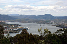
Hobart is the capital and most populous city of the island state of Tasmania, Australia. Home to almost half of all Tasmanians, it is the southernmost and least-populated Australian state capital city, and second-smallest if territories are taken into account, before Darwin, Northern Territory. Hobart is located in Tasmania's south-east on the estuary of the River Derwent, making it the most southern of Australia's capital cities. Its skyline is dominated by the 1,271-metre (4,170 ft) kunanyi/Mount Wellington, and its harbour forms the second-deepest natural port in the world, with much of the city's waterfront consisting of reclaimed land. The metropolitan area is often referred to as Greater Hobart, to differentiate it from the City of Hobart, one of the seven local government areas that cover the city. It has a mild maritime climate.

<span class="mw-page-title-main">River Derwent (Tasmania)</span> River in south east Tasmania, Australia

The River Derwent is a river located in Tasmania, Australia. It is also known by the palawa kani name timtumili minanya. The river rises in the state's Central Highlands at Lake St Clair, and descends more than 700 metres (2,300 ft) over a distance of more than 200 kilometres (120 mi), flowing through Hobart, the state's capital city, before emptying into Storm Bay and flowing into the Tasman Sea. The banks of the Derwent were once covered by forests and occupied by Aboriginal Tasmanians. European settlers farmed the area and during the 20th century many dams were built on its tributaries for the generation of hydro-electricity.

<span class="mw-page-title-main">Tasman Bridge</span> Highway bridge over the River Derwent in Hobart, Tasmania, Australia

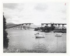
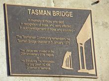
The Tasman Bridge is a prestressed concrete girder bridge connecting the Tasman Highway over the River Derwent in Hobart, Tasmania, Australia. When it opened on 29 March 1965, the Tasman was the longest prestressed concrete bridge in Australia, with a total length measuring 1,396 metres (4,580 ft), including approaches. The bridge provides a vital link between Hobart's city centre on the western shore and the City of Clarence on the eastern shore. Averaging 73,029 vehicle crossings per day, the bridge is the highest volume road section in Tasmania. It features five lanes of traffic including a central lane equipped for tidal flow operations and separated shared-use walkways on both sides, with ramp upgrades for improved access and cyclists completed in 2010.

The history of Tasmania begins at the end of the Last Glacial Period when it is believed that the island was joined to the Australian mainland. Little is known of the human history of the island until the British colonisation of Tasmania in the 19th century.

<span class="mw-page-title-main">City of Clarence</span> Local government area in Tasmania, Australia

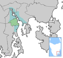
Clarence City Council is a local government body in Tasmania, and one of the five municipalities that constitutes the Greater Hobart Area. The Clarence local government area has a population of 61,531, covering the eastern shore of the Derwent River from Otago to the South Arm Peninsula and the smaller localities of Cambridge, Richmond, and Seven Mile Beach.

<span class="mw-page-title-main">Tasman Highway</span> Highway in Tasmania, Australia

The Tasman Highway is a highway in Tasmania, Australia. Like the Midland Highway, it connects the major cities of Hobart and Launceston – however it takes a different route, via the north-eastern and eastern coasts of the state. The Highway also acts as a major commuter road to Hobart residents living on the eastern side of the Derwent River. The designation "Tasman Highway" arises from its location facing the Tasman Sea – named, like the state itself, after Abel Tasman. The highway is one of the longest in Tasmania – 410 km (250 mi), with an average travelling time of 412 hours.

<span class="mw-page-title-main">Bowen Bridge</span> Bridge crossing the Derwent River in Tasmania, Australia

The Bowen Bridge is a segmental cantilever road bridge crossing the River Derwent in Tasmania, Australia. The bridge serves as a vital transportation link in the state capital of Hobart, facilitating the movement of vehicles, pedestrians, and cyclists between the local government areas of Clarence on the eastern shore and Glenorchy on the western shore. The Bowen Bridge links the East Derwent Highway with the Brooker Highway at Glenorchy, approximately 10 kilometres (6.2 mi) from the Hobart city centre.

Montagu Bay is a suburb of Hobart, Tasmania, located in the City of Clarence on the eastern shore of the Derwent River, about four kilometres from the city centre of greater Hobart. It is a small primarily residential suburb located between Rosny, Rose Bay and Lindisfarne and is centred on a small bay of the same name, formerly known as Smelting Works Bay. The bay has a boat ramp and jetty, and is frequently filled with yachts and other vessels at anchor.

<span class="mw-page-title-main">Bridgewater Bridge (Tasmania)</span> Road and rail bridge in Tasmania, Australia

The Bridgewater Bridge is a combined road and rail bridge that carries the Midland Highway and South Railway Line across the Derwent River in Hobart, Tasmania, Australia. This steel truss vertical lift bridge and specially-built causeway connect the Hobart suburbs of Bridgewater and Granton. The bridge was completed in 1946 and accommodates a two-lane highway, a single track railway and a grade-separated footpath.

MV <i>Cartela</i> Transport vessel in Tasmania, Australia

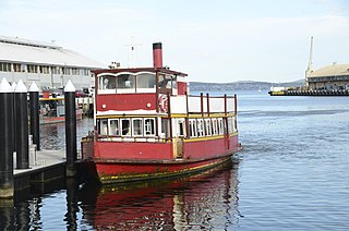
The MV Cartela is an excursion vessel operating on the Derwent River in Hobart, Tasmania, Australia. She is now Australia's oldest continuously-licensed passenger vessel, although there are several older vessels still in service that have been restored after lengthy periods in dereliction.

The modern history of the Australian city of Hobart in Tasmania dates to its foundation as a British colony in 1804. Prior to British settlement, the area had been occupied definitively for at least 8,000 years, and possibly for as long as 35,000 years, by the semi-nomadic Mouheneener tribe, a sub-group of the Nuenonne, or South-East tribe. The descendants of theses indigenous Tasmanians now refer to themselves as 'Palawa'. Little is known about the region from prehistoric times. As with many other Australia cities, urbanisation has destroyed much of the archaeological evidence of indigenous occupation, although aboriginal middens are often still present in coastal areas.

<span class="mw-page-title-main">Spirit of Tasmania</span> Operators of the ferry service between Tasmania and Victoria

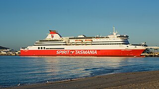
TT-Line Company Pty Ltd, better known by its trading name Spirit of Tasmania is a company which has been operating ferries from mainland Australia to Tasmania since July 1985. The company was separated from the Tasmanian Government's Department of Transport in 1993, becoming a government business enterprise wholly owned by the Government of Tasmania where it was then named Spirit of Tasmania in August 1993.

SS <i>Lake Illawarra</i> Bulk ore carrier which collided with the Tasman Bridge in 1975

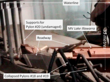
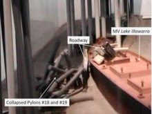
SS Lake Illawarra was a handysize bulk carrier of 7,274 tons in the service of the Australian National Line. This ship is known for causing the Tasman Bridge disaster when she collided with pylon 19 of Hobart's giant high concrete arch style Tasman Bridge on the evening of 5 January 1975 at 9.27 pm, resulting in the deaths of 12 people.

<span class="mw-page-title-main">Australian National Line</span> Government Owned Shipping Line

Australian National Line (ANL) was a coastal shipping line established by the Government of Australia in 1956. It was sold in 1998 by the Howard government to CMA CGM.

<span class="mw-page-title-main">Rose Bay, Tasmania</span> Suburb of Hobart, Tasmania, Australia

Rose Bay is a suburb of the City of Clarence in greater Hobart, capital city of Tasmania, Australia. Rose Bay is a small suburb, making up only approximately 0.9 square kilometres with nearly one fourth of that area (23.2%) being parkland. At the 2016 Census the suburb recorded a population of 1,102 people.

<span class="mw-page-title-main">Bruny Island Ferry</span> Ferry route from Kettering to Bruny Island in Tasmania, Australia

The Bruny Island Ferry links Bruny Island to the Tasmanian mainland. Once operated by North Western Shipping and Towage Co. Pty Ltd and owned by the Tasmanian Government, the ferry Mirambeena travels between Kettering on the Tasmanian mainland and Roberts Point on Bruny Island, the service is now run by Sealink. The service is subsidised by the Tasmanian Government.

<span class="mw-page-title-main">Ferries in Hobart</span>

Ferries in Hobart are a form of public transport in the city of Hobart, Tasmania, though they have not provided a major alternative public transport service for commuters and tourists in Hobart and other localities in and around the Derwent River in recent decades.

Tasmanian Steam Navigation Company Limited was an Australian steaming company, formed in Hobart in 1853 and defunct in 1922 after a series of acquisitions. It operated a shipping service from Tasmania to the Australian Mainland, later expanded to New Zealand.

The Tasmanian Seafarers' Memorial is a public memorial structure located at Triabunna, Tasmania which jointly commemorates all Tasmanians who died at sea, along with the lives of all seafarers of any origin who lost their lives in Tasmanian waters. The memorial comprises individual commemorative plaques for each maritime tragedy involving recreational, commercial, mercantile or naval vessels and personnel lost since 1803. As of February 2017, the memorial contained plaques for 116 events involving the loss of over 1450 lives.

<i>Kosciusko</i> (ferry)

Kosciusko was a "K-class" ferry on Sydney Harbour. Launched in 1911, the timber-hulled steamer was built for Sydney Ferries Limited during the boom in cross-harbour ferry travel prior to the opening of the Sydney Harbour Bridge.

References

  1. 1 2 "The Tasman Bridge Collapse". Emergency Management Australia. Archived from the original on 7 October 2007. Retrieved 30 September 2008.
  2. "Tasmanian Shipwrecks". Oceans Enterprises. Retrieved 2 October 2008.
  3. 1 2 "The Monaro Man". Australian Broadcasting Corporation. March 2002. Retrieved 2 October 2008.
  4. 1 2 "Tasman Bridge". Australia Network. 15 January 2007. Archived from the original on 1 August 2008. Retrieved 2 October 2008.
  5. Tragic Sunday - The icy Derwent River claimed 12 lives when a ship rammed Hobart's Tasman Bridge messui.the-chronicles.org
  6. "Australian Maritime Issues 2005" (PDF). Royal Australian Navy. 13 April 2006. Archived from the original (PDF) on 30 December 2008. Retrieved 30 September 2008.
  7. "Victims of Tasman Bridge disaster honoured with memorials, families hope for closure". ABC News. 27 February 2016.
  8. "Man missing since Tasman Bridge disaster in 1975, Dr Thomas Elvet Jones, declared dead". ABC News. 15 May 2015.
  9. Lee, T (1981). Adjustment in the Urban System: The Tasman Bridge Collapse and Its Effects Upon Metropolitan Hobart. Pergamon.
  10. 1 2 3 "The Bridge of Sighs". Time Magazine. 16 August 1976. Archived from the original on 11 March 2007. Retrieved 3 October 2008.
  11. 1 2 "Tasmanian Year Book 2000". Australian Bureau of Statistics. December 2006. Retrieved 30 September 2008.
  12. 1 2 3 4 5 "Tasman Bridge Disaster: 25th Anniversary Memorial Service" (PDF). Emergency Management Australia. 13 March 2001. Archived from the original (PDF) on 17 March 2012. Retrieved 18 June 2012.
  13. New terminals for ferries on three weeks Canberra Times 11 January 1975 page 1
  14. A Friend in Need Transport News March 1975 page 3
  15. "Time running out to restore historic Tasmanian steamship Cartela". ABC News. 23 May 2021.
  16. Gordon, R. "The Social Dimension of Disaster Recovery" (PDF). Recovery. Emergency Management Australia. p. 111. Archived from the original (PDF) on 17 March 2012. Retrieved 18 June 2012.
  17. "Incat History - Development of passenger/vehicle ferries". incat.com. Retrieved 29 June 2022.
  18. "Tasman Bridge Statistics". Government of Tasmania. Retrieved 30 September 2008.
  19. "Tasman Bridge Disaster". Government of Tasmania. Retrieved 30 September 2008.
  20. "Australian Road Financing Statistics 1970–1980" (PDF). Bureau of Transport Economics. 9 March 2001. Archived from the original (PDF) on 22 July 2008. Retrieved 30 September 2008.
  21. 1 2 "Safety First for Bridge Design" (PDF). AustRoads, republished by Cambridge University Dept of Engineering. 3 May 2004. Retrieved 5 October 2008.
  22. "Collapse resistance and robustness of bridges" (PDF). International Association for Bridge Maintenance Safety and Management. 1 April 2008. Retrieved 5 October 2008.
  23. Holbrook, Martin (1999). "Real Time System to Aid Vessel Manoeuvering in the Derwent River". Coasts & Ports 1999: Challenges and Directions for the New Century; Proceedings of the 14th Australasian Coastal and Ocean Engineering Conference and the 7th Australasian Port and Harbour Conference. Engineers Australia: 279. Retrieved 5 January 2019.
  24. "Marine and Safety (Pilotage and Navigation) Regulations". Government of Tasmania. Retrieved 5 October 2008.

Further reading