Texas Towers

Last updated
Texas Tower
Air Defense Command.svg
Part of Air Defense Command (ADC)
Texas Tower 3.jpg
TypeOffshore air defense radar
Site information
ConditionOut of service/demolished
Site history
Built byFlag of the United States Air Force.svg  United States Air Force
In use1958–1963
MaterialsSteel

Texas Towers were a set of three radar facilities off the eastern seaboard of the United States which were used for surveillance by the United States Air Force during the Cold War. Modeled on the offshore oil drilling platforms first employed off the Texas coast, they were in operation from 1958 to 1963. After the collapse of one of the towers in 1961, the remaining towers were closed due to changes in threat perception and out of a concern for the safety of the crews.

Contents

Planning

Texas Towers
Location map; towers 1 and 5 were planned, but not built.

Upon re-formation of the Air Defense Command in 1951 to oversee the nation's developing surveillance radar network, there was concern that shore-based radars along the east coast provided insufficient warning time. A 1952 report from MIT's Lincoln Laboratory looked into the possibility of extending radar coverage by building platforms in the Atlantic using offshore oil drilling technology. [1] They concluded that a set of such platforms, equipped with radars, could extend coverage several hundred miles offshore, giving half an hour additional warning of an attack. [2] Funding for design and construction of the towers was approved in January 1954. [1]

Design

Texas Tower 2; note tropospheric scatter dish antennae on edge of platform Texas Tower 2 radar platform in 1956.jpg
Texas Tower 2; note tropospheric scatter dish antennae on edge of platform

Each tower consisted of a triangular platform, 200 feet (61 m) on each side, standing on three caisson legs. [3] [4] The structures were constructed on land, towed to site, and jacked up to clear the sea surface by 67 feet (20 m). [3] Radar and other equipment were then installed on location. The platform itself contained two floors housing the living areas; two of the legs held fuel oil for diesel generators, while the third held the intake for the desalination unit. The platform roof served as a helicopter landing area. A rotary gantry was suspended from the platform to allow servicing of its underside.

Each platform was equipped with one AN/FPS-3 (later upgraded to AN/FPS-20) search radar and two AN/FPS-6 height finder radars, each housed in a separate spherical neoprene radome 55 feet (17 m) in diameter. [4] Originally the towers were to be linked to shore by submarine cable, but this was eventually rejected as too costly; the AN/FRC-56 tropospheric scatter microwave link was installed instead, with an array of three parabolic antennas attached to one edge of the platform. [2] UHF and VHF equipment allowed communication with ships and aircraft as well as providing a backup to the microwave link.

Installations

Five towers were planned, in an array off the New England/mid-Atlantic coast. The most northerly two proposed were dropped from plans due to budgetary constraints. [2]

Tower IDLocationStaffing unitMainland stationNotes
TT-1Cashes Ledge off New Hampshire coast
42°53′N68°57′W / 42.883°N 68.950°W / 42.883; -68.950
Not built
TT-2 Georges Bank off Cape Cod
41°45′0.00″N67°46′0.00″W / 41.7500000°N 67.7666667°W / 41.7500000; -67.7666667
762d Radar Squadron North Truro Air Force Station decommissioned 1963
TT-3 Nantucket Shoals
40°45′00.00″N69°19′0.00″W / 40.7500000°N 69.3166667°W / 40.7500000; -69.3166667
773d Radar Squadron Montauk AFS decommissioned 1963
TT-4 off Long Beach Island, New Jersey
39°48′N72°40′W / 39.800°N 72.667°W / 39.800; -72.667
646th Radar Squadron Highlands Air Force Station collapsed (1961)
TT-5 Browns Bank south of Nova Scotia
42°47′N65°37′W / 42.783°N 65.617°W / 42.783; -65.617
Not built

Logistical support for all three towers was provided by the 4604th Support Squadron, based out of Otis AFB and specifically constituted for this mission. [2] They were originally equipped with H-21B helicopters, [2] which were replaced with three Sikorsky SH-3 helicopters acquired in 1962. [5] The USNS New Bedford was used to supply the stations, with transfer being effected with a platform called the "donut", consisting of an inflated rubber ring surmounted by a railing, which was lowered from the platform to the waiting ship's deck. These transfers could only take place at slack tide, when the ship could maintain position. [6]

Operational history

Texas Tower 2 was the first to become operational, starting limited service in May 1956. [7] It became fully operational in 1958, as did Tower 3; Tower 4 followed in April 1959. [8] The original plan to integrate these radars into the SAGE system had to be modified when the direct cable connection was eliminated; instead, they were used to provide manual inputs.

All the towers were noisy and prone to vibration from the equipment. The relative flexibility of the supports also caused them to shake and sway in response to wind and waves. [6] The frequent and sustained sounding of the platform's foghorns was also an annoyance to the crew. [2]

Texas Tower 4

Texas Tower 4 before installation of cross-braces Texas Tower 4.jpg
Texas Tower 4 before installation of cross-braces

Tower 4 was plagued with structural problems from the start. It stood in much deeper water than the other two - 185 feet (56 m), compared to 80 feet (24 m) for Tower 2 - and it was held that the simple cylindrical leg design would not be sturdy enough given the length of the legs. Therefore, three sets of cross braces were added between the legs, attached with pin joints. [2] [9] These made it impossible to tow the platform on the level; instead, the structure was laid on its side for transport and then tipped upright at the site. [9] These braces proved to be frail and the joints prone to loosening: two braces broke loose during transport, and a third was lost when the tower was being placed on the bottom. [10] Divers were brought in several times to inspect the structure and to perform repairs, and an additional set of crossbraces was installed immediately below the platform, above the waterline, in 1960. [11] Crewmen were frequently seasick from the swaying, and Tower 4 was nicknamed "Old Shaky". [2]

On September 12, 1960, Hurricane Donna passed over Tower 4, causing severe structural damage, including the loss of the flying bridge hanging beneath the platform, and one of the communications dishes. [12] After assessment of the damage and initial repairs it was decided to reduce staffing to a skeleton crew and prepare to dismantle the station. [12] The site could not simply be abandoned for fear that the Soviets would board it and remove sensitive equipment and documentation. [12] Dismantling of the tower was therefore protracted. At the approach of another storm in January 1961, evacuation of the station was impeded by the inability of the commander to make contact with any of his three immediate superiors; nonetheless the New Bedford set out for the platform. [13] As the storm built, USS Wasp, which was in the vicinity, was also dispatched with the intent of evacuating the station via helicopter, shore aircraft being unable to take off. [13] Both ships reached the vicinity but could do no more than watch the station disappear from their radar. No survivors were recovered, though divers were sent down on the chance that some might have been trapped in the wreckage. [13] Twenty-eight airmen and civilian contractors perished. [14] Only two bodies were recovered. [14]

Texas Tower 5

Texas Tower 5
Part of Aerospace Defense Command
Coordinates 42°47′N65°37′W / 42.783°N 65.617°W / 42.783; -65.617
TypeLong Range Radar Site
Site information
Owner U.S. Air Force
Site history
Built byU.S. Government

Texas Tower 5 was planned to be built on Brown's Bank, 35 nautical miles (65 km; 40 mi) south of the coast of Nova Scotia in 84 feet (26 m) of water. [15] The 4604th Support Group was supposed to be located at Pease Air Force Base, New Hampshire. The USAF approved the construction of Tower #5 on January 11, 1954, but the tower was never built because of improvements to radar over the area.

Closure

The loss of Tower 4, together with the increasing emphasis on ICBMs as the predominant threat, led a reassessment of the remaining towers. Escape capsules were added to the two remaining towers, allowing rapid evacuation. [2] [4] Shortly thereafter it was decided to close the remaining towers, and the electronic equipment was removed. Both platforms were expected to be returned to shore for scrap, but Tower 2 sank and could not be recovered. Tower 3 was then filled with foam before being knocked off its support, and it was successfully returned to shore and dismantled. The wreckage of Towers 2 and 4 remains in place on the ocean floor. Radar coverage was taken over by alterations to EC-121 airborne early warning flights based out of Otis Air Force Base. [2]

See also

Related Research Articles

<span class="mw-page-title-main">Radome</span> Weatherproof structures enclosing radar antennas

A radome is a structural, weatherproof enclosure that protects a radar antenna. The radome is constructed of material transparent to radio waves. Radomes protect the antenna from weather and conceal antenna electronic equipment from view. They also protect nearby personnel from being accidentally struck by quickly rotating antennas.

<span class="mw-page-title-main">Clear Space Force Station</span> US Space Force station in Alaska

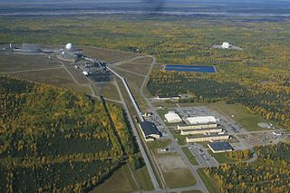
Clear Space Force Station is a United States Space Force radar station for detecting incoming ICBMs and submarine-launched ballistic missiles to NORAD's command center and to provide Space Surveillance data to the United States Space Force. Clear's AN/FPS-123 Upgraded Early Warning Radar is part of the Solid State Phased Array Radar System (SSPARS) which also includes those at Beale AFB, Cape Cod Space Force Station, RAF Fylingdales and Thule Site J. The "historic property" was one of the Alaska World War II Army Airfields and later a Cold War BMEWS site providing NORAD data to Colorado's BMEWS Central Computer and Display Facility (CC&DF).

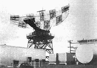
The AN/FPS-35 frequency diversity radar was a long range search radar used in the early 1960s. It was one of the largest air defense radars ever produced, with its antenna and supporting structure mounted on one of the largest rolling-element bearings in the world.

Montauk Air Force Station was a US military base at Montauk Point on the eastern tip of Long Island, New York. It was decommissioned in 1981 and is now owned by the New York State Office of Parks, Recreation and Historic Preservation as Camp Hero State Park.

Mount Hebo Air Force Station is a closed United States Air Force General Surveillance Radar station. It is located 5.2 miles (8.4 km) east-southeast of Hebo, Oregon, located at the top of 3,154-foot (961 m) Mount Hebo. It was closed in 1980.

<span class="mw-page-title-main">North Truro Air Force Station</span> Radar station in Massachusetts, US 1951–1994

North Truro Air Force Station (AFS) is a closed United States Air Force General Surveillance Radar station. It is located 2.2 mi (3.5 km) east of North Truro, Massachusetts.

<span class="mw-page-title-main">Texas Tower 2</span> Former US Air Force radar station

Texas Tower 2 was a former United States Air Force Texas Tower General Surveillance Radar station, first operational in 1955. It was located 110 miles (180 km) east of Cape Cod, Massachusetts, in 56 feet (17 m). The tower was closed in 1963 and dismantled.

<span class="mw-page-title-main">Texas Tower 3</span> United States Air Force radar station

Texas Tower 3 was a former United States Air Force Texas Tower General Surveillance Radar station, first operational in November 1956. The radar station was 50 miles (80 km) southeast of the coast of Nantucket, Massachusetts, in 80 feet of water. The tower was closed in 1963 and dismantled.

<span class="mw-page-title-main">Texas Tower 4</span> Radar station of the United States Air Force

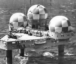
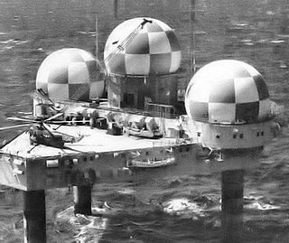
Texas Tower 4 was a United States Air Force Texas Tower General Surveillance Radar station, located 63 miles (101 km) south-southeast off the coast of Long Island, New York in 185 feet (56 m) of water. Hurricane Donna struck the tower in September 1960, seriously damaging it. The tower was the site of an accident and was destroyed by a winter storm on January 15, 1961. None of the twenty-eight airmen and civilian contractors who were manning the station survived.

<span class="mw-page-title-main">General Electric AN/FPS-8 Radar</span> Cold War-era American air defense radar

The AN/FPS-8 Radar was a Medium-Range Search Radar used by the United States Air Force Air Defense Command.

<span class="mw-page-title-main">AN/FPS-24 radar</span>

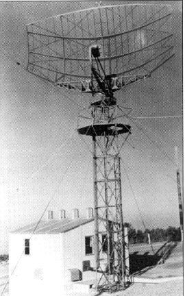
The AN/FPS-24 Radar was a long range early warning radar used by the United States Air Force Air Defense Command. It used a two-frequency signal in order to avoid fluctuation loss, which causes signals on single-frequency radars to fade in and out as the target moves. Reducing this effect results in a much steadier signal.

The Avco AN/FPS-26 Radar was an Air Defense Command height finder radar developed in the Frequency Diversity Program with a tunable 3-cavity power klystron for electronic counter-countermeasures (e.g. to counter jamming). Accepted by the Rome Air Development Center on 20 January 1960 for use at SAGE radar stations, the AN/FPS-26 processed height-finder requests (e.g., from Air Defense Direction Centers) by positioning to the azimuth of a target aircraft using a high-pressure hydraulic drive, then "nodding" in either a default automatic mode or by operator command. The inflatable radome required a minimum pressure to prevent contact with the antenna which would result in damage to both (technicians accessed the antenna deck via an air lock.) To maintain high dielectric strength, the waveguide was pressurized with sulfur hexafluoride (SF6), which technicians were warned would produce deadly fluorine if waveguide arcing occurred.

<span class="mw-page-title-main">Cape Charles Air Force Station</span> Former US Air Force radar station

Cape Charles Air Force Station is a closed United States Air Force General Surveillance Radar station. It is located 3.6 miles (5.8 km) south of Townsend, Virginia. It was closed in 1981. From 1941 to 1948 it was Fort John Custis of the United States Army Coast Artillery Corps. Since 1984 the site has been in the Eastern Shore of Virginia National Wildlife Refuge. For this article's purposes the term "Fort John Custis" includes the nearby Fisherman Island.

<span class="mw-page-title-main">Bendix AN/FPS-14 Radar</span>

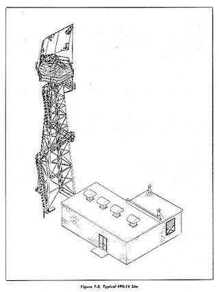
The AN/FPS-14 was a medium-range search Radar used by the United States Air Force Air Defense Command.

The AN/FPS-18 was a medium-range search Radar used by the United States Air Force Air Defense Command.

<span class="mw-page-title-main">4604th Support Squadron</span> Military unit

The 4604th Support Squadron (Texas Towers) is an inactive United States Air Force unit. It was last assigned to the 26th Air Division, Aerospace Defense Command, stationed at Otis Air Force Base, Massachusetts. It was inactivated on 1 July 1963.

<span class="mw-page-title-main">14th Test Squadron</span> Military unit

The 14th Test Squadron is a United States Air Force unit located at Schriever Air Force Base, Colorado. It is an Air Force Reserve unit that augments the 17th Test Squadron. The squadron is responsible for testing and evaluating space systems and associated support equipment. The unit was originally established in 1972 as the 14th Missile Warning Squadron. The missile warning squadron was an active duty unit that operated early warning radars at eight locations around the United States until it was inactivated in 1980. The squadron was reactivated and given its current space test mission in 2000.

An Arctic Tower is a 20 ft diameter cylindrical radar station structure of the AN/GPA-33 Radar Set Group for protecting a USAF radar's antenna and electronic cabinets. Designed for low temperatures and strong winds, the 25 ft high tower's top platform supported an antenna group and a 20 ft high CW-313/FPS radome which was "capable of withstanding two inches of ice" and winds of 109 knots. The 25,000 lb Arctic Tower was designed for supporting Radar Set AN//TPS-10D (AN/FPS-4) or Radar Set AN/TPS-1D, and could support other systems up to a load of 100psf on the 20 foot diameter platform, the interior 2nd floor, or the ground floor. In addition to protecting a radar system, the tower housed other AN/GPA-33 equipment such as the Radome Interior Control Group (OA-709/GPA-33) which included

<span class="mw-page-title-main">Radar tower</span>

A radar tower is a tower whose function is to support a radar facility, usually a local airport surveillance radar, and hence often at or in the vicinity of an airport or a military air base. The antenna is often continually rotating. In addition, radar towers are used for the installation and operation of search and height finder radars at military radar stations, where the mission is to support air defense missions. These missions were characterized as Aircraft Control & Warning (AC&W), or Long Range Surveillance in support of the Semi-Automatic Ground Environment (SAGE).

<span class="mw-page-title-main">Saugatuck Gap Filler Radar Annex</span> Last cold War radar installation

The Saugatuck Gap Filler Annex is a decommissioned air defense radar installation previously of the United States Air Force. It served in the vast Cold War era Semi-Automatic Ground Environment (SAGE) air defense system. Of the hundreds of SAGE radars, Saugatuck's is one of, perhaps, two that remain nearly completely intact.

References

  1. 1 2 Keeney, L. Douglas (2011). 15 Minutes: General Curtis LeMay and the Countdown to Nuclear Annihilation. Macmillan. p. 100.
  2. 1 2 3 4 5 6 7 8 9 10 Ray, Thomas W. "A History of Texas Towers in Air Defense 1952-1964". Texas Tower Association. Archived from the original on 2010-07-15. Retrieved 2012-01-23.
  3. 1 2 Howe, Hartley E. (October 1955). "Radar Island Rises 110 Miles at Sea". Popular Science : 126–129, 268. Retrieved 2012-01-22.
  4. 1 2 3 Kaufmann, J. E.; Kaufmann, H. W. (2004). Fortress America: The forts that defended America, 1600 to the present . Da Capo Press. pp.  371–372. Retrieved 2012-01-22.
  5. "Rotary Wing Aircraft". Flying : 117. November 1962. Retrieved 2012-01-22.
  6. 1 2 Wylie, Evan McLeod (July 26, 1963). "Farewell to the Iron Bastards: Texas Towers Await the Wreckers". Life . pp. 7, 9. Retrieved 2012-01-22.
  7. Leonard, Barry, ed. (2011). History of Strategic and Ballistic Missile Defense: Volume II: 1956-1972. DIANE Publishing. ISBN   9781437921311. p. 305
  8. Leonard, p. 312
  9. 1 2 Keeney, pp. 150-152
  10. Keeney, p. 190
  11. Keeney, pp. 226-228
  12. 1 2 3 Keeney, pp.229-232
  13. 1 2 3 Keeney, pp.262-275
  14. 1 2 Southall, Ashley, "Obama Recognizes Men Who Died in the Collapse of a Radar Tower in 1961", New York Times , 9 February 2011; retrieved 14 February 2011.
  15. "The Texas Towers: Proposed". The Texas Towers.Com. Archived from the original on 2011-07-25. Retrieved 2009-06-20.