
The British Virgin Islands (BVI), officially the Virgin Islands, are a British Overseas Territory in the Caribbean, to the east of Puerto Rico and the US Virgin Islands and north-west of Anguilla. The islands are geographically part of the Virgin Islands archipelago and are located in the Leeward Islands of the Lesser Antilles and part of the West Indies.

The British Virgin Islands (BVI) are one of three political divisions of the Virgin Islands archipelago located in the Lesser Antilles, between the Caribbean Sea and the North Atlantic Ocean. The BVI are the easternmost part of the island chain. The land area totals and comprises 16 inhabited and more than 20 uninhabited islands. The islands of Tortola, Anegada, Virgin Gorda and Jost van Dyke are the largest. Maritime claims include 12 nmi territorial sea and a 200 nmi exclusive fishing zone. In terms of land use, it is 20% arable land, 6.67% permanent crops and 73.33% other as of a 2005 figure. It has strong ties to nearby U.S. Virgin Islands and Puerto Rico.
Karlu Karlu / Devils Marbles Conservation Reserve is a protected area in the Northern Territory of Australia located in the locality of Warumungu about 105 km (65 mi) south of Tennant Creek, and 393 km (244 mi) north of Alice Springs. The nearest settlement is the small town of Wauchope located 9 km (5.6 mi) to the south.

Alum Bay is a bay near the westernmost point of the Isle of Wight, England, within close sight of the Needles rock formation. Of geological interest and a tourist attraction, the bay is noted for its multi-coloured sand cliffs. The waters and adjoining seabed form part of the Needles Marine Conservation Zone and the shore and heath above are part of the Headon Warren and West High Down Site of Special Scientific Interest.

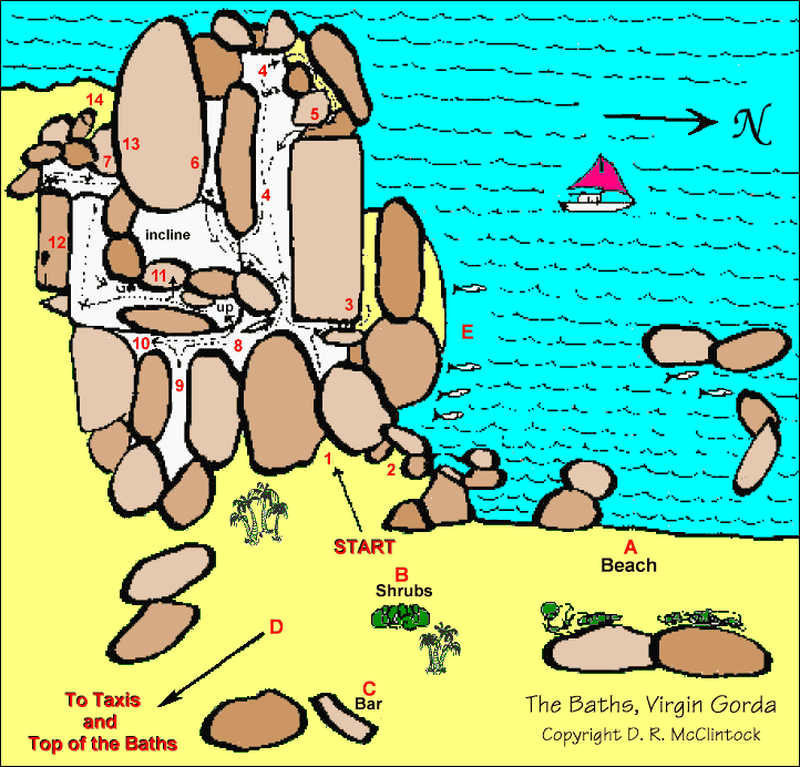
Virgin Gorda is the third-largest island and second-most populous of the British Virgin Islands (BVI).

The Virgin Islands National Park is an American national park preserving about 60% of the land area of Saint John in the United States Virgin Islands, as well as more than 5,500 acres of adjacent ocean, and nearly all of Hassel Island, just off the Charlotte Amalie, Saint Thomas harbor.

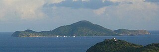
Anegada is the northernmost of the British Virgin Islands (BVI), a group of islands that form part of the archipelago of the Virgin Islands. It lies approximately 15 miles (24 km) north of Virgin Gorda. Anegada is the only inhabited British Virgin Island formed from coral and limestone, rather than being of volcanic origin. While the other islands are mountainous, Anegada is flat and low. Its highest point is only about 28 feet (8.5 m) above sea level, earning it its name, which is the Spanish term for the flooded land, "tierra anegada".

Tortola is the largest and most populated island of the British Virgin Islands, a group of islands that form part of the archipelago of the Virgin Islands. It has a surface area of 55.7 square kilometres with a total population of 23,908, with 9,400 residents in Road Town. Mount Sage is its highest point at 530 metres above sea level.

Jost Van Dyke is the smallest of the four main islands of the British Virgin Islands, measuring roughly 8 square kilometres. It rests in the northern portion of the archipelago of the Virgin Islands, located in the Atlantic Ocean and Caribbean Sea. Jost Van Dyke lies about 8 km (5 mi) to the northwest of Tortola and 8 km (5 mi) to the north of Saint John. Little Jost Van Dyke lies off its eastern end.
Spanish Town on southern Virgin Gorda is the second largest town on the British Virgin Islands. Also known as Valley, Spanish Town offers numerous shopping possibilities. The heart of the town is its Yacht Harbor marina, with many bareboat sailing activities every day. It has its own airport and a ferry service is in operation from here to Road Town on Tortola and Trellis Bay on Beef Island. Overall, though, Spanish Town is small, with few bars and a relaxed atmosphere. The national park "The Baths" is located south of Spanish Town.

Eustatia Island is a 30-acre island of the British Virgin Islands (BVI) in the Caribbean. The word "Eustatia" is a Greek derived word meaning, "good place to stay." The entire island, and a small neighboring island, Saba Rock, are under the same long term lease. The island is regularly featured and photographed for several publications and was listed as one of the top 20 most beautiful islands in the world in the December 2004 issue of Islands magazine.

Saba Rock is a small island of the British Virgin Islands in the Caribbean, approximately an acre and a half in size. The island contains a small hotel, restaurant, bar, and gift shop. A dock is available for day visitors and a large mooring field accommodates yachts staying overnight. The resort operates a boat shuttle from Saba Rock to Bitter End Yacht Club and Leverick Bay Marina.
Cooper Island is a small island of the British Virgin Islands in the Caribbean.
The following outline is provided as an overview of and topical guide to the British Virgin Islands:

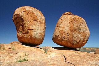
A balancing rock, also called a balanced rock or precarious boulder, is a naturally occurring geological formation featuring a large rock or boulder, sometimes of substantial size, resting on other rocks, bedrock, or on glacial till. Some formations known by this name only appear to be balancing, but are in fact firmly connected to a base rock by a pedestal or stem.

Cape Town lies at the south-western corner of the continent of Africa. It is bounded to the south and west by the Atlantic Ocean, and to the north and east by various other municipalities in the Western Cape province of South Africa.
Polar Caves Park is a set of glacially-formed caves located in New Hampshire's White Mountains region, in the United States. The caves were formed during the last ice age from granite boulders and are so named because the deepest cave is cold enough to allow snow to linger long into the summer.

Wairere Boulders is a privately-owned nature reserve and tourist attraction at Horeke in the south Hokianga region of Northland, New Zealand. The property contains geologically rare rock formations. Visitors to the property can walk around the various trails, kayak down the boulder river and stay at the campsite.

East End is an administrative subdistrict of the island of St. Thomas in the United States Virgin Islands. The largest community is Red Hook, while smaller communities include Benner, Nazareth, Nadir, Frydendal, and Smith Bay. The subdistrict includes the offshore islands of Great Saint James, Little Saint James, Bovoni Cay, Patricia Cay, Cas Cay, Rotto Cay, Thatch Cay, Shark Island, and Dog Island.


