The Haven, Boston

Last updated

The Grand Sluice at Boston, where the River Witham empties into The Haven. The lock is on the far right. GrandSluiceDownstreamBoston.jpg
The Grand Sluice at Boston, where the River Witham empties into The Haven. The lock is on the far right.

The Haven is the tidal river of the port of Boston, Lincolnshire in England. It provides access for shipping between Boston Deeps in The Wash and the town, particularly, the dock. It also serves as the outfall into the sea, of the River Witham and of several major land drains of the northern Fens of eastern England, which are known collectively as the Witham Navigable Drains. ( TF 337 426 ).

Contents

Physical and economic development

The Haven, Boston
BSicon uSTR.svg
River Witham
BSicon uxABZgl.svg
BSicon uSTR+r.svg
BSicon CONTgq.svg
BSicon uxmKRZu.svg
BSicon umKRZu.svg
BSicon CONTfq.svg
Railway bridge
BSicon uxWEIRg.svg
BSicon uSEALOCKu.svg
Grand Sluice and sea lock
BSicon uexSKRZ-Au.svg
BSicon uSKRZ-Au.svg
A1137 bridge
BSicon uexSTRl.svg
BSicon ueABZg+r.svg
(tidal below here)
BSicon uKRZuw.svg
Footbridge
BSicon uSKRZ-Yu.svg
High Street bridge
BSicon uSKRZ-Au.svg
A16 bridge
BSicon CONTgq.svg
BSicon umKRZusw.svg
BSicon CONTfq.svg
Railway swing bridge
BSicon uxABZq+r.svg
BSicon uxHSTRbm.svg
BSicon ueABZg+r.svg
Black Sluice pumping station
BSicon uSTRl.svg
BSicon uLockr.svg
BSicon uFABZgr+r.svg
South Forty-Foot Drain
BSicon uENDE.svg
Proposed barrage
BSicon uFABZgl+l.svg
BSicon uLockr.svg
BSicon uDOCKr.svg
Boston Docks
BSicon ueABZg+l.svg
BSicon uxWEIRfl.svg
BSicon uexSTRq.svg
Maud Foster Drain
BSicon uSTR.svg
BSicon ueABZg+l.svg
BSicon uxWEIRfl.svg
BSicon uexABZq+l.svg
Hobhole Drain and sluice
BSicon ueABZg+l.svg
BSicon uxHSTRbm.svg
BSicon uexSTRr.svg
Hobhole pumping station
BSicon uSTR.svg
BSicon uDOCKSa.svg
The Wash

The English settlers who arrived in The Wash, found tidal creeks which gave them entry to the habitable belt of land, inland from the salt-marshes. These creeks, they called "havens". There was a route inland from The Haven, with which this article deals, on which Boston later developed, to the upland of Lindsey. However, the port of Boston did not develop until after natural events had diverted the River Witham into The Haven during the eleventh century.

Simultaneously, this took the river away from Drayton, which had become the successor port of Swineshead as its estuary accumulated silt. The Swin had been to Swineshead what the Zwin was to Bruges but after the loss of the Witham, Bicker became more important than Drayton so its estuary became known as Bicker Haven.

At the time of the Domesday Book (1086), the accounting for Boston was still done under the heading of the manors of Drayton but the wealth of Drayton's holdings, as recorded in the Domesday Book, in Skirbeck makes the presence of a working port at Boston, which then lay in Skirbeck, near certain.

Before The Witham broke into it, The Haven's head was in the area which subsequently became the Market Place. The likely date for the switch of the Witham from Drayton to The Haven is 1014, the date recorded by the Anglo-Saxon Chronicle as one of unprecedented sea floods. There was another serious flood, later in the century but that came after 1086.

Subsequently, Boston and its Haven became busy with trade as wool was brought into the town for export, particularly to Flanders.

Modern port

The "Fehn Cartagena" unloading a cargo of stone while moored on a mudbank in The Haven, opposite the Black Sluice FehnCartagenaAtTheHavenBoston.jpg
The "Fehn Cartagena" unloading a cargo of stone while moored on a mudbank in The Haven, opposite the Black Sluice

Nowadays, the activity has moved below the old centre of the town. The fishing fleet moors below the railway bridge and trading vessels lie either in tidal berths beside the dock where there are facilities for handling scrap steel or in the dock itself where there are facilities for handling paper, steel coil and grain as well as timber and general cargo, including containers.

Boston Barrier

Historically, Boston has been affected by tidal flooding, caused by tidal surges passing up The Haven from the Wash. Flooding from this cause was particularly severe in 1953 and 1978. [1] Following the creation of a new tidal lock in 2008 to allow boats to enter the South Forty-Foot Drain from the Haven, phase 1b of the project to create a navigable waterway between Boston and Spalding involved the construction of the Boston Barrier. As well as being part of wider flood defence works, this would allow boats to pass through Boston town centre to access the South Forty Foot Drain at most states of the tide. At the time, it was expected that work would be completed by 2013, [2] but work did not start, and serious flooding occurred again in 2013, when over 800 homes and 79 businesses were inundated. Following a public enquiry in 2017, a £100 million project to build the barrier and associated flood defence works on both sides of the river, including widening the access to the Port of Boston wet dock, was awarded by the Environment Agency to the civil engineers BMMJV, a joint venture consisting of BAM Nuttall and Mott MacDonald. [1]

The main components of the scheme were a rising sector gate, 85 feet (26 m) wide by 36 feet (11 m) high, which can be raised to prevent tidal surges moving further upstream, and a vertical sector gate, 59 feet (18 m) wide by 38 feet (11.6 m) high, to control the entrance to the wet dock. The rising sector gate weighs 362 tonnes and is moved by two 55-tonne hydraulic rams. The scheme also included a control building for the barrier, higher flood defence walls along the river, including landscaping of the right bank, and the placing of matting on the bed of the river either side of the barrier, to prevent scouring undermining the structure. The construction of the barrier was innovative, as it is quite different to the Thames Barrier in its design, and the only other similar structure, that at Ipswich on the River Orwell, is some 30 per cent smaller, and had not been commissioned at the time the Boston Barrier project began. [1] Work began on the project in 2018, [3] and the sector gate, which was manufactured in Holland, was delivered in November 2019. The gate was operational by December 2020, and the completed scheme offers better flood protection to over 13,000 homes and businesses. The entrance to the wet dock was widened from 52 feet (16 m) to 59 feet (18 m), with the existing timber V-gates being replaced by a single pair of vertical sector gates. [4]

Because the work affected navigation, it was authorised by a Transport and Works Act 1992 Order. [2] The Transport and Works Act (1992) was introduced to simplify the process of obtaining permission for the construction or alteration of railways and inland navigations, and any work which interferes with rights of navigation. [5] The completed barrier was recognised in the civil engineering world, receiving six awards, four from the Institution of Civil Engineers, one from the Royal Institute of Chartered Surveyors, and an Environment Agency Flood and Coast Award. [4]

Historical connection

In 1607, The Haven, between Boston and the sea ( TF 361 402 ), was the scene of the first, abortive, attempt of the Scrooby Pilgrims, to leave England. Ultimately, in 1620, they became part of the original settlement of Plymouth, Massachusetts. [6]

See also

Related Research Articles

<span class="mw-page-title-main">Boston, Lincolnshire</span> Town and port in Lincolnshire, England

Boston is a market town and inland port in the borough of the same name in the county of Lincolnshire, England.

<span class="mw-page-title-main">The Wash</span> Bay and estuary on east coast of England

The Wash is a rectangular bay and multiple estuary at the north-west corner of East Anglia on the East coast of England, where Norfolk meets Lincolnshire and both border the North Sea. One of Britain's broadest estuaries, it is fed by the rivers Witham, Welland, Nene and Great Ouse. It is a 620 km² biological Site of Special Scientific Interest. It is also a Nature Conservation Review site, Grade I, a National Nature Reserve, a Ramsar site, a Special Area of Conservation and a Special Protection Area. It is in the Norfolk Coast Area of Outstanding Natural Beauty and part of it is the Snettisham Royal Society for the Protection of Birds nature reserve.

<span class="mw-page-title-main">River Witham</span> River in eastern England

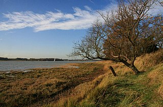
The River Witham is a river almost entirely in the county of Lincolnshire in the east of England. It rises south of Grantham close to South Witham at SK8818, passes through the centre of Grantham, passes Lincoln at SK9771 and at Boston, TF3244, flows into The Haven, a tidal arm of The Wash, near RSPB Frampton Marsh. The name "Witham" seems to be extremely old and of unknown origin. Archaeological and documentary evidence shows the importance of the Witham as a navigable river from the Iron Age onwards. From Roman times it was navigable to Lincoln, from where the Fossdyke was constructed to link it to the River Trent. The mouth of the river moved in 1014 following severe flooding, and Boston became important as a port.

<span class="mw-page-title-main">River Orwell</span> River in Suffolk, England

The River Orwell flows through the county of Suffolk in England from Ipswich to Felixstowe. Above Ipswich, the river is known as the River Gipping, but its name changes to the Orwell at Stoke Bridge, where the river becomes tidal. It broadens into an estuary at Ipswich, where the Ipswich dock has operated since the 7th century, and then flows into the North Sea at Felixstowe, the UK's largest container port, after joining the River Stour at Shotley forming Harwich harbour.

<span class="mw-page-title-main">River Hull</span> River in the East Riding of Yorkshire, England

The River Hull is a navigable river in the East Riding of Yorkshire in Northern England. It rises from a series of springs to the west of Driffield, and enters the Humber Estuary at Kingston upon Hull. Following a period when the Archbishops of York charged tolls for its use, it became a free navigation. The upper reaches became part of the Driffield Navigation from 1770, after which they were again subject to tolls, and the section within the city of Hull came under the jurisdiction of the Port of Hull, with the same result.

<span class="mw-page-title-main">Foss Dyke</span> Canal that connects the River Trent to Lincoln

The Foss Dyke, or Fossdyke, connects the River Trent at Torksey to Lincoln, the county town of Lincolnshire, and may be the oldest canal in England that is still in use. It is usually thought to have been built around AD 120 by the Romans, but there is no consensus among authors. It was refurbished in 1121, during the reign of King Henry I, and responsibility for its maintenance was transferred to the city of Lincoln by King James I. Improvements made in 1671 included a navigable sluice or lock at Torksey, and warehousing and wharves were built at Brayford Pool in the centre of Lincoln.

<span class="mw-page-title-main">South Forty-Foot Drain</span> Drainage canal in eastern England

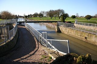
The South Forty-Foot Drain, also known as the Black Sluice Navigation, is the main channel for the land-drainage of the Black Sluice Level in the Lincolnshire Fens. It lies in eastern England between Guthram Gowt and the Black Sluice pumping station on The Haven, at Boston. The Drain has its origins in the 1630s, when the first scheme to make the Fen land available for agriculture was carried out by the Earl of Lindsey, and has been steadily improved since then. Water drained from the land entered The Haven by gravity at certain states of the tide until 1946, when the Black Sluice pumping station was commissioned.

Lincolnshire is a large county in England with a sparse population distribution, which leads to problems funding all sorts of transport. The transport history is long and varied, with much of the road network still based on the Roman model, and the once extensive rail network a shadow of its former self.

<span class="mw-page-title-main">Bicker, Lincolnshire</span> Village in Boston, Lincolnshire, England

Bicker is a village in the Borough of Boston, Lincolnshire, England. The population of the village was 941 at the 2011 census. It is situated approximately 9 miles (10 km) west-south-west from Boston, and on the A52 road.

<span class="mw-page-title-main">Port of Rotterdam</span> Seaport in the Netherlands

The Port of Rotterdam is the largest seaport in Europe, and the world's largest seaport outside of East Asia, located in and near the city of Rotterdam, in the province of South Holland in the Netherlands. From 1962 until 2004, it was the world's busiest port by annual cargo tonnage. It was overtaken first in 2004 by the port of Singapore, and since then by Shanghai and other very large Chinese seaports. In 2020, Rotterdam was the world's tenth-largest container port in terms of twenty-foot equivalent units (TEU) handled. In 2017, Rotterdam was also the world's tenth-largest cargo port in terms of annual cargo tonnage.

<span class="mw-page-title-main">Lincolnshire coast</span> Part of the English coastline

The coast of Lincolnshire runs for more than 50 miles (80 km) down the North Sea coast of eastern England, from the estuary of the Humber to the marshlands of the Wash, where it meets Norfolk. This stretch of coastline has long been associated with tourism, fishing and trade.

<span class="mw-page-title-main">Forty Foot Drain</span>

The Forty Foot or Forty Foot Drain is a name given to several of the principal channels in the drainage schemes of the Fens of Eastern England, the name being qualified when there is a need to distinguish between them. They are Vermuyden's Drain, South Forty Foot and North Forty Foot.

<span class="mw-page-title-main">River Freshney</span> River in North East Lincolnshire, England

The River Freshney is a river in the English county of North East Lincolnshire. The town of Grimsby stands on its banks. It rises from at least four springs on the edge of the Lincolnshire Wolds, although local folklore and oral tradition has it springing from Welbeck Hill. Originally it entered the tidal Humber estuary at Pyewipe, north west of Grimsby, but has been re-routed and now supplies Grimsby Docks. There was an existing haven within the borough of Grimsby but this suffered greatly with silting problems so in 1669 landowners agreed to the diversion of the Freshney through the town to the haven to provide fresh water and improve the flow. It is believed the work was completed in the very early 18th century.

<span class="mw-page-title-main">Fens Waterways Link</span> Waterways project in eastern England

The Fens Waterways Link is a project to improve recreational boating opportunities in the counties of Cambridgeshire and Lincolnshire, England. By a combination of improvements to existing waterways and the construction of new links a circular route between Lincoln, Peterborough, Ely and Boston is planned. The project is being organised by the Environment Agency and financed from the Regional Development Agency and the European Union.

<span class="mw-page-title-main">Anton's Gowt</span> Hamlet in the East Lindsey district of Lincolnshire, England

Anton's Gowt is a hamlet in the East Lindsey district of Lincolnshire, England. It is situated approximately 2 miles (3 km) north-west from the market town and port of Boston. It is the most southerly village within the East Lindsey district.

<span class="mw-page-title-main">Witham Navigable Drains</span> United Kingdom legislation

The Witham Navigable Drains are located in Lincolnshire, England, and are part of a much larger drainage system managed by the Witham Fourth District Internal Drainage Board. The Witham Fourth District comprises the East Fen and West Fen, to the north of Boston, which together cover an area of 97 square miles (250 km2). In total there are over 438 miles (705 km) of drainage ditches, of which under 60 miles (97 km) are navigable. Navigation is normally only possible in the summer months, as the drains are maintained at a lower level in winter, and are subject to sudden changes in level as a result of their primary drainage function, which can leave boats stranded. Access to the drains is from the River Witham at Anton's Gowt Lock.

<span class="mw-page-title-main">Black Sluice</span>

The Black Sluice is the name given to the structure that controls the flow of the South Forty-Foot Drain into The Haven, at Boston, Lincolnshire, England.

<span class="mw-page-title-main">Hedon Haven</span> River and port in the East Riding of Yorkshire, England

Hedon Haven is a waterway that connected the Humber Estuary with the port of Hedon, in Holderness, East Riding of Yorkshire, England. The waterway allowed ships to unload at the port in Hedon, which was also known as Hedon Haven and had, at its peak, three canalised arms that stretched into the town. The port at Hedon was the main port for south Holderness between the 12th and 13th centuries, and was the busiest port in Holderness before the docks at Hull were built.

<span class="mw-page-title-main">Lagoon Hull</span> Proposed lagoon in the Humber Estuary, England

Lagoon Hull is a proposed £1.5 billion development on the Humber Estuary foreshore between Hessle and Kingston upon Hull, in the East Riding of Yorkshire, England. The proposed lagoon would be formed from a stone causeway and will provide an outer lock gate in the Humber Estuary which would effectively dam the River Hull, making it a non-tidal waterway. The 11-kilometre (6.8 mi) long causeway would also provide a dual carriageway from the A63 at Hessle which would run to Hull Docks, taking traffic away from the city centre. The scheme is being vaunted as one that will prevent future flooding in Hull when sea levels rise, and contribute to less flooding in the wider Humber Estuary.

<span class="mw-page-title-main">Centre Port</span>

Centre Port is a proposed development across The Wash in Eastern England, which would link Norfolk and Lincolnshire by road. The plan is to link Hunstanton in Norfolk, with Gibraltar Point in Lincolnshire, creating an 11-mile (18 km) road, with a port and a railway at the midway point. Additionally the development would be a tidal barrage to prevent sea flooding, and would use tidal power to create enough electricity to power 600,000 homes. Whilst no formal plans have yet been submitted, the scheme has come under widespread criticism from those living in the area and from wildlife groups.

References

  1. 1 2 3 Bell, Gelder & Zalmay 2019.
  2. 1 2 Woolford 2008, p. 7.
  3. "Work starts on Boston's £100m flood barrier scheme". BBC News. Archived from the original on 16 July 2018. Retrieved 26 June 2018.
  4. 1 2 Bell et al. 2021.
  5. "A Guide to Transport and Works Act Procedures". Department of Transport. p. 2.
  6. "It is claimed that the Pilgrim Fathers set sail from Plymouth..." BBC History Extra. 1 December 2016. Archived from the original on 23 August 2020.

Bibliography