
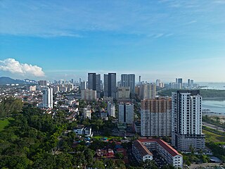
George Town is the capital of the Malaysian state of Penang. It is the core city of the George Town Conurbation, Malaysia's second largest metropolitan area with a population of 2.84 million and the second highest contributor to the country's GDP. The city proper spans an area of 306 km2 (118 sq mi) encompassing Penang Island and surrounding islets, and had a population of 794,313 as of 2020.

The Tun Abdul Razak Complex, formerly the PenangUrban Centre, is a civic complex within the central business district of George Town in the Malaysian state of Penang. At the time of its completion in 1985, Komtar Tower, at 231.7 metres (760 ft), was the second tallest building in Asia and the tallest in Southeast Asia until 1986 when it was surpassed by One Raffles Place in Singapore. Other buildings in the complex include a hotel building, four shopping malls, an urban park, and a central transportation hub. The complex contains 1,420,000 square feet (132,000 m2) of office and retail space on a 27-acre (11 ha) superblock. It currently houses the administrative offices of the Penang state government and the chief minister of Penang.

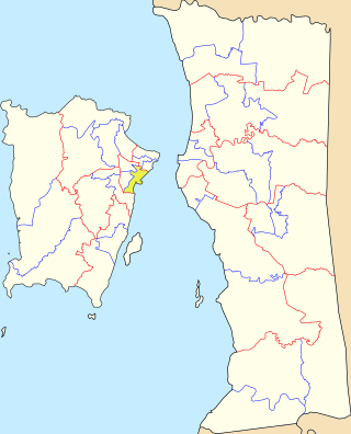
Penang Island is the main constituent island of the Malaysian state of Penang. It is located off the western coast of Peninsular Malaysia by the Malacca Strait, with the Penang Strait separating the island from Seberang Perai on the mainland. The 295 km2 (114 sq mi) island makes up approximately 28% of Penang's total land mass and is home to about 45% of the state's population as of 2020. The entire island falls under the city of George Town, which also administers the surrounding islets.

Gelugor is a suburb of George Town in the Malaysian state of Penang. Named after a plant species, Gelugor lies along the eastern seaboard of Penang Island, between Jelutong and Sungai Dua, and nearly 5 km (3.1 mi) south of the city centre.
Jelutong is a suburb of George Town in the Malaysian state of Penang. Located 3.2 km (2.0 mi) south of the city centre, Jelutong has been inhabited since as early as the late 18th century, when traders from Aceh and India settled around the area.

Batu Uban is a residential neighbourhood within the city of George Town in the Malaysian state of Penang, about 6.7 km (4.2 mi) south of the city centre. Founded by ethnic Minangkabaus in the early 18th century, Batu Uban is regarded as the oldest Malay settlement on Penang Island.
Batu Lanchang is a residential neighbourhood within the downtown core of George Town in the Malaysian state of Penang. It is sandwiched between Farlim to the west and Jelutong to the east.

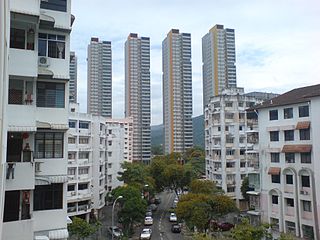
Farlim, officially Bandar Baru Ayer Itam, is a residential neighbourhood within the city of George Town in the Malaysian state of Penang. Located 6 km (3.7 mi) southwest of the city centre, the township was created in the 1980s. Over the recent decades, Farlim has witnessed rapid development with several residential and commercial developments within the area.
Seri Tanjong Pinang is a suburb within the city of George Town in the Malaysian state of Penang. It lies 4.5 km (2.8 mi) northwest of the city centre and was created on land reclaimed off Tanjong Tokong in the 1990s. The suburb also encompasses Gurney Bay and the ongoing reclamation project of Andaman Island.

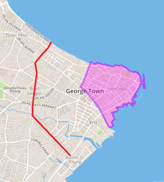
Tun Dr Lim Chong Eu Expressway or Federal Route 3113, is an expressway on Penang Island, that connects the city centre of George Town with Batu Maung at the city's south. This 17.84 km (11.09 mi) expressway stretches along the eastern coast of Penang Island. It was named in honour of Penang's second Chief Minister Tun Dr Lim Chong Eu who died in 2010. There are two sections of the expressway, the Jelutong Expressway and Bayan Lepas Expressway.

Karpal Singh Drive is a seafront promenade in George Town within the Malaysian state of Penang. Located at Bandar Sri Pinang, it faces the Penang Strait and was named after Karpal Singh (1940-2014), a prominent opposition politician and lawyer who hailed from the city.
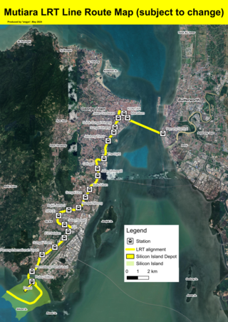
The Mutiara LRT line is a proposed light rapid transit system in Penang. The 29 kilometres (18 mi) line is planned to connect George Town's city centre with its southern suburbs of Jelutong, Gelugor and Bayan Lepas, with a link towards Seberang Perai across the Penang Strait. Once completed, it is owned by the Mass Rapid Transit Corporation (MRTC). The line, a component of the Penang Transport Master Plan (PTMP), is projected to contain 22 stations. Construction of the line is expected to begin in September or October 2024, and will be completed by 2030.

Gurney Bay, formerly known as Gurney Wharf, is a seafront park within George Town in the Malaysian state of Penang. Intended as a "new iconic waterfront destination for Penang", the first phase of this public space off Gurney Drive was opened to public in 2024.

The Pinang River is a river that runs through the city of George Town within the Malaysian state of Penang. Stretching for approximately 3.5 kilometres (2.2 mi), the river cuts through the city centre, passing under the Tun Dr Lim Chong Eu Expressway before emptying into the Penang Strait.
Sungai Pinang is a state constituency in Penang, Malaysia, that has been represented in the Penang State Legislative Assembly since 1974. It covers much of Jelutong, one of the suburbs of George Town.
George Town Inner Ring Road is an urban ring road within the city of George Town in Penang, Malaysia. It comprises the eastern end of Gurney Drive, Jalan Pangkor, Jalan Perak and Jalan Sungai Pinang, forming a loop within the city centre.

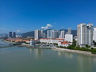
Bandar Sri Pinang is a residential neighbourhood within the city of George Town in the Malaysian state of Penang. Situated within the city centre, it is bounded by the Pinang River to its north and the Tun Dr Lim Chong Eu Expressway to its west. Comprising a mix of low-cost and luxury residential, commercial and light industrial developments, the neighbourhood was formed in 2014 through land reclamation by Malaysian conglomerate IJM Corporation.
Central George Town is the city centre of George Town, the capital of the Malaysian state of Penang. It corresponds to the eponymous subdivision of George Town, which is mostly identical to the original city limits established when George Town was granted city status in 1957.

The Clan Jetties form a residential neighbourhood within the city of George Town in the Malaysian state of Penang. Situated within the city's central business district, it now comprises seven wooden villages lining the coastal road of Weld Quay, each owned by residents of a specific Chinese clan – Ong, Lim, Chew, Tan, Lee, Mixed Clan and Yeoh jetties.
The Ayer Itam–Tun Dr Lim Chong Eu Expressway Bypass is a dual carriageway under construction in the city of George Town within the Malaysian state of Penang. The 6 km (3.7 mi) road will connect the inland neighbourhood of Farlim to the coastal Tun Dr Lim Chong Eu Expressway. Slated for completion by 2025, the bypass is part of the Penang Transport Master Plan, which aims to alleviate traffic congestion in the state through the implemention of three new roadways.


