The economy of East Timor is a low-income economy as ranked by the World Bank. It is placed 133rd on the Human Development Index, indicating a medium level of human development. 20% of the population is unemployed, and 52.9% live on less than $1.25 a day. About half of the population is illiterate. At 27%, East Timor's urbanisation rate is one of the lowest in the world.

The term territorial waters is sometimes used informally to refer to any area of water over which a sovereign state has jurisdiction, including internal waters, the territorial sea, the contiguous zone, the exclusive economic zone, and potentially the extended continental shelf. In a narrower sense, the term is often used as a synonym for the territorial sea.

The Timor Sea is a relatively shallow sea in the Indian Ocean bounded to the north by the island of Timor with Timor-Leste to the north, Indonesia to the northwest, Arafura Sea to the east, and to the south by Australia. The Sunda Trench marks the deepest point of the Timor Sea with a depth of more than 3300 metres, separating the continents of Oceania in the southeast and Asia to the northwest and north. The Timor sea is prone to earthquakes and tsunamis north of the Sunda Trench, due to its location on the Ring of Fire as well as volcanic activity and can experience major cyclones, due to the proximity from the Equator.

An exclusive economic zone (EEZ), as prescribed by the 1982 United Nations Convention on the Law of the Sea, is an area of the sea in which a sovereign state has special rights regarding the exploration and use of marine resources, including energy production from water and wind. It stretches from the outer limit of the territorial sea out to 200 nautical miles (nmi) from the coast of the state in question. It is also referred to as a maritime continental margin and, in colloquial usage, may include the continental shelf. The term does not include either the territorial sea or the continental shelf beyond the 200 nautical mile limit. The difference between the territorial sea and the exclusive economic zone is that the first confers full sovereignty over the waters, whereas the second is merely a "sovereign right" which refers to the coastal state's rights below the surface of the sea. The surface waters are international waters.

The Malaysia–Thailand border divides the countries of Malaysia and Thailand and consists of a land boundary running for 595 km (370 mi) across the Malay Peninsula and maritime boundaries in the Straits of Malacca and the Gulf of Thailand/South China Sea. The Golok River forms the easternmost 95 km stretch of the land border.

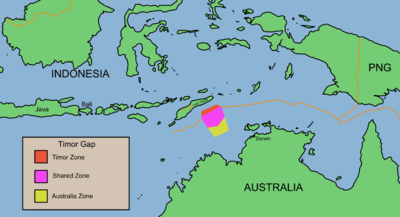
The Timor Gap Treaty was formally known as the Treaty between Australia and the Republic of Indonesia on the zone of cooperation in an area between the Indonesian province of East Timor and Northern Australia. It was a bilateral treaty between the governments of Australia and Indonesia, which provided for the joint exploitation of petroleum and hydrocarbon resources in a part of the Timor Sea Seabed. The treaty was signed on 11 December 1989 and came into force on 9 February 1991. The signatories to the treaty were then Australian Foreign Affairs Minister Gareth Evans and then Indonesian Foreign Minister Ali Alatas.
Ambalat is a sea block in the Celebes sea located off the east coast of Borneo. It lies to the east of the Indonesian province of North Kalimantan and to the south-east of the Malaysian state of Sabah, and it is the subject of a territorial dispute between the two nations. Malaysia refers to part of the Ambalat block as Block ND6 (formerly Block Y) and part of East Ambalat Block as Block ND7 (formerly Block Z). The deep sea blocks contain an estimated 62,000,000 barrels (9,900,000 m3) of oil and 348 million cubic meters of natural gas. Other estimates place it substantially higher: 764,000,000 barrels (121,500,000 m3) of oil and 3.96 × 10¹⁰ cubic meters (1.4 trillion cubic feet) of gas, in only one of nine points in Ambalat.

The Indonesia–Malaysia border consists of a 1,881 km land border that divides the territory of Indonesia and Malaysia on the island of Borneo. It also includes maritime boundaries along the length of the Straits of Malacca, in the South China Sea and in the Celebes Sea.
The borders of Malaysia include land and maritime borders with Brunei, Indonesia and Thailand and shared maritime boundaries with Philippines, Singapore and Vietnam.
Malaysia and Vietnam are two Southeast Asian countries with maritime boundaries which meet in the Gulf of Thailand and South China Sea. The two countries have overlapping claims over the continental shelf in the Gulf of Thailand. Both countries have, however, come to an agreement to jointly exploit the natural resources in the disputed area pending resolution of the dispute over sovereignty.

Formally known as the Timor Sea Treaty between the Government of East Timor and the Government of Australia was signed between Australia and East Timor in Dili, East Timor on 20 May 2002, the day East Timor attained its independence from United Nations rule, for joint petroleum exploration of the Timor Sea by the two countries. The signatories of the treaty were then Australian prime minister John Howard and his East Timorese counterpart at that time Mari Alkatiri.
The Australia–Indonesia border is a maritime boundary running west from the two countries' tripoint maritime boundary with Papua New Guinea in the western entrance to the Torres Straits, through the Arafura Sea and Timor Sea, and terminating in the Indian Ocean. The boundary is, however, broken by the Timor Gap, where Australian and East Timorese territorial waters meet and where the two countries have overlapping claims to the seabed.
Officially called the Treaty between Australia and the Democratic Republic of Timor-Leste on Certain Maritime Arrangements in the Timor Sea (CMATS), the treaty provides for the equal distribution of revenue derived from the disputed Greater Sunrise oil and gas field between Australia and East Timor. The field is located in the Timor Gap where Australia and East Timor have overlapping claims over the continental shelf or seabed. Prior to the treaty, East Timor would only have received about 18% of the revenue from the field.
This agreement is officially known as the Agreement between the Government of Australia and the Government of the Democratic Republic of Timor-Leste relating to the Unitisation of the Sunrise and Troubadour Fields.
The East Timor and Indonesia Action Network (ETAN) is a nonprofit US organization supporting human rights throughout Southeast Asia and Oceania. ETAN was founded in 1991 to support the right to self-determination of Timor-Leste. In 1999, that goal was significantly realized when the people of East Timor voted for independence. Since then ETAN has focused on building on its success in support of justice and self-determination in Timor-Leste and the surrounding region.
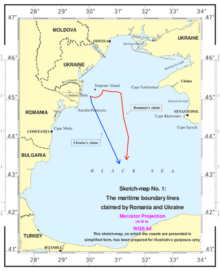
The Case concerning maritime delimitation in the Black Sea (Romania v Ukraine) [2009] ICJ 3 was a decision of the International Court of Justice (ICJ). On September 16, 2004, Romania brought its case to the court after unsuccessful bilateral negotiations. On February 3, 2009, the court handed down its verdict, establishing a maritime boundary including the continental shelf and exclusive economic zones for Romania and Ukraine.

Bilateral relations exist between Australia and East Timor. Both countries are near neighbors with close political and trade ties. East Timor, the youngest and one of the poorest countries in Asia, lies about 610 kilometres northwest of the Australian city of Darwin and Australia has played a prominent role in the young republic's history.

The Australia–East Timor spying scandal began in 2004 when the Australian Secret Intelligence Service (ASIS) clandestinely planted covert listening devices in a room adjacent to the East Timor (Timor-Leste) Prime Minister's Office at Dili, to obtain information in order to ensure Australia held the upper hand in negotiations with East Timor over the rich oil and gas fields in the Timor Gap. Even though the East Timor government was unaware of the espionage operation undertaken by Australia, negotiations were hostile. The first Prime Minister of East Timor, Mari Alkatiri, bluntly accused the Howard government of plundering the oil and gas in the Timor Sea, stating:
"Timor-Leste loses $1 million a day due to Australia's unlawful exploitation of resources in the disputed area. Timor-Leste cannot be deprived of its rights or territory because of a crime."

Australia's exclusive economic zone (EEZ) was declared on 1 August 1994 and extends from 12 to 200 nautical miles from the coastline of Australia and its external territories, except where a maritime delimitation agreement exists with another state. To the 12 nautical-mile boundary is Australia's territorial waters. Australia has the third-largest exclusive economic zone, behind France and the United States but ahead of Russia, with the total area of 8,148,250 square kilometres (3,146,060 sq mi), which exceeds its land territory.
The borders of Indonesia include land and maritime borders with Malaysia, Papua New Guinea, and Timor Leste, as well as shared maritime boundaries with Australia, India, Palau, Philippines, Singapore, Thailand, and Vietnam.