
The province of Pescara is a province in the Abruzzo region of Italy. Its capital is the city of Pescara, which has a population of 119,483 inhabitants. As of 2017, it has a total population of 319,936 inhabitants over an area of 1,230.33 square kilometres (475.03 sq mi). The provincial president is Antonio Zaffiri and the province contains 46 comuni.
Crecchio is a comune and village in the province of Chieti, part of the Abruzzo region in central Italy. The village preserves its medieval aspect and is dominated by its castle. It is a member of the I Borghi più belli d'Italia association. Its main activities are agriculture and tourism, yet small family-run businesses exist.

The Aterno-Pescara is a river system in Abruzzo, eastern central Italy. The river is known as the Aterno near its source in the mountains, but takes the name Pescara, actually a tributary, nearer the city of Pescara and the Adriatic Sea.
Città Sant'Angelo is a city and comune in the province of Pescara, Abruzzo, Italy. It is a member of the I Borghi più belli d'Italia association.

Archi is a town and comune in the province of Chieti, Abruzzo, southern Italy. It is part of the Valsangro mountain community.
San Giovanni Teatino is a comune and town in the Province of Chieti in the Abruzzo region of Italy. Until 1894 this comune was known as Forcabobolina. Situated on a hill overlooking the valley of the river Pescara (Aterno-Pescara), in recent years the place has undergone an industrial development, especially in the area of Sambuceto. Abruzzo Airport is also located in a portion of the municipal territory, close to the border with Pescara. In fact, the municipality is virtually divided into two, San Giovanni Teatino (Alto), which is the historic village on the hill, and the aforementioned Sambuceto, an ever-growing urban settlement, home to a large shopping area and an important industrialized area.<>
Civitella Messer Raimondo is a town in the province of Chieti in the Abruzzo region of Italy, with a population of 890. It is part of the mountain community of Aventino-Medio Sangro. Until 1863, it was known only as Civitella.

Francavilla al Mare is a comune and town in the province of Chieti, in the Abruzzo region of Italy.
Pizzoferrato is a comune and town in the Province of Chieti in the Abruzzo region of Italy.
Cansano is a comune in the province of L'Aquila in the Abruzzo region, Southern Italy. It is part of the Maiella National Park. Cansano is known for the archaeological discovery of the Italic and Roman town of Ocriticum, which has become an archaeological park.
Pratola Peligna is a comune and town in the Province of L'Aquila in the Abruzzo region of Italy. As of 2015, it has a population of 7,652 inhabitants.

Castiglione a Casauria is a comune and town in the province of Pescara in the Abruzzo region of Italy. It is located in the natural park known as the "Gran Sasso e Monti della Laga National Park".

Salle is a comune and town in the Province of Pescara in the Abruzzo region of Italy, well known for its castle and its history in the violin-string industry.

Pietranico is a village and comune of the province of Pescara in the Abruzzo region of central Italy.

Popoli Terme is a comune and town in the province of Pescara, in the Italian region of Abruzzo.
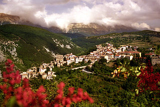
Sant'Eufemia a Maiella is a town and comune in the province of Pescara, Abruzzo, central Italy. It is located in the Maiella National Park in a valley enclosed by the western slopes of the Majella massif, and the northeastern slopes of the Morrone group.

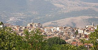
Torre de' Passeri is an Italian town of 3,172 inhabitants in the province of Pescara in Abruzzo. It owes its name to the ancient "Turris Passum", a tower located near the Abbey of San Clemente a Casauria. A prominent feature of Torre de' Passeri is Castello Gizzi, which overlooks the entire town. Historical-enological researches have suggested that the area might be the native land of the Montepulciano vine. Torre de' Passeri is twinned with Manteigas in Portugal.
Montefino is a small town and predominantly rural comune of the province of Teramo in the Abruzzo region of eastern Italy. During the second half of the twentieth century the population of the comune declined steadily from 2,399 in 1951 to 1,184—less than half—in 2001.

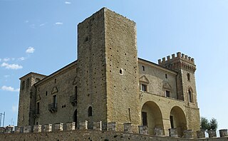
Castello Caracciolo is a Middle Ages castle in Tocco da Casauria, Province of Pescara (Abruzzo).

The history of Tocco da Casauria traces its origins to the foundation of the first settlement of Interpromium in ancient times. After the disappearance of that settlement in the Middle Ages, the present town of Tocco was formed, developing around the two most important town buildings as a result of a succession of rivalries between the Abbey of San Clemente a Casauria, to which the territories of Tocco belonged de jure, and lords of Germanic origin who attempted to usurp them by force.


