Tocobaga

Last updated
Tocobaga chiefdom
Regions with significant populations
Tampa Bay, Florida
Religion
Native American
Related ethnic groups
Mocoso, Pohoy, Uzita

Tocobaga (occasionally Tocopaca) was the name of a chiefdom of Native Americans, its chief, and its principal town during the 16th century. The chiefdom was centered around the northern end of Old Tampa Bay, the arm of Tampa Bay that extends between the present-day city of Tampa and northern Pinellas County. The exact location of the principal town is believed to be the archeological Safety Harbor site. This is the namesake for the Safety Harbor culture, of which the Tocobaga are the most well-known group.

Contents

The name "Tocobaga" is often applied to all of the native peoples of the immediate Tampa Bay area during the first Spanish colonial period (1513–1763). While they were culturally very similar, most of the villages on the eastern and southern shores of Tampa Bay were likely affiliated with other chiefdoms, such as the Pohoy, Uzita, and Mocoso. Study of archaeological artifacts has provided insight into the everyday life of the Safety Harbor culture.

But, little is known about the political organization of the early peoples of the Tampa Bay area. The scant historical records come exclusively from the journals and other documents made by members of several Spanish expeditions that traversed the area in the 1500s.

The Tocobaga and their neighbors disappeared from the historical record by the early 1700s, as endemic diseases carried by European explorers decimated the local population. They had no medical acquired immunity to these new diseases. Survivors were displaced by the raids and incursions of other indigenous groups from the north. The Tampa Bay area was virtually uninhabited for over a century.

Encounters with Spanish explorers in the sixteenth century

Estimated extent of Tocobaga influence at first contact with Spanish explorers TocobagaTerritory.GIF
Estimated extent of Tocobaga influence at first contact with Spanish explorers

The Tampa Bay area was visited by Spanish explorers during Florida's early Spanish period. In 1528, an expedition led by Pánfilo de Narváez landed near Tampa Bay and soon skirmished with the indigenous population, probably at the principal town of the Tocobaga at the Safety Harbor site.

Several years later, the Hernando de Soto Expedition likely landed on the southern shore of Tampa Bay in 1539, [lower-alpha 1] and passed through the eastern part of Safety Harbor territory after occupying the village of Uzita.

Garcilaso de la Vega (known as el Inca), in his history of de Soto's expedition, relates that Narváez had ordered that the nose of the chief of Uzita be cut off, indicating that the two explorers had passed through the same area. Another town near Uzita encountered by de Soto was Mocoso, but evidence suggests that, while Mocoso was in the Safety Harbor culture area together with Uzita and Tocobaga, the Mocoso people spoke a different language, possibly Timucua. Neither Narvaez nor de Soto remained in the area for long, as they each traveled north in search of gold after several violent encounters with the Tocobaga and their neighbors.

The missionary expedition of Father Luis de Cancer visited the Tampa Bay area in 1549 to attempt to peacefully convert the locals to Christianity. He intended to build a relationship between the Spanish and indigenous Floridians in the aftermath of earlier visits by aggressive conquistadors. Despite being cautioned to avoid the Gulf Coast, Father Cancer's expedition came ashore just south of the mouth of Bahia Espiritu Santo (Tampa Bay) in May 1549. There they encountered apparently peaceful and receptive Natives who told them of the many populous villages around Tampa Bay. Father Cancer decided to continue north to visit these towns and was met with violent resistance. Most members of the expedition were killed or captured, and Father Cancer was clubbed to death soon after reaching modern day Pinellas County. [7]

Hernando de Escalante Fontaneda, a shipwreck survivor who lived with the Natives of southern Florida from 1549–1566 and was rescued from the Calusa by Pedro Menéndez de Avilés, described Tocobaga, Abalachi (Apalachee) and Mogoso (Mocoço) as "separate kingdoms" from the Calusa. Ucita and Mocoço at the time of de Soto's visit were subject to a chief named Urriparacoxi or Paracoxi (also given as Urribarracuxi). [lower-alpha 2] De Soto marched to the town of Paracoxi, which appears to have been inland from Tampa Bay, where he found maize being cultivated. (By contrast, the Safety Harbor people made little or no use of maize, and instead gathered most of their food and resources from the bountiful coastal waters.) [9]

The name "Tocobaga" first appears in Spanish documents in 1567, when Pedro Menéndez de Avilés visited what was almost certainly the Safety Harbor site. Menéndez had contacted the Calusa and reached an accommodation with Carlos, the Calusa king. Menéndez married Carlos's sister. [10]

As Carlos was anxious to gain an advantage over his enemy Tocobaga, Menéndez took Carlos and 20 of his warriors to Tocobaga by ship. Menéndez persuaded Tocobaga and Carlos to make peace. He recovered several Europeans and a dozen Calusa being held as slaves by Tocobaga. Leaving a garrison of 30 men at Tocobaga ( to encourage the people of the town to convert to Christianity), he returned Carlos and the other Calusa to their town. In January 1568, Spanish boats taking supplies to the garrison at Tocobaga found the town deserted, and all the Spanish soldiers dead. [10]

Later history

In 1608 an alliance of Pohoy and Tocobaga may have threatened Potano people who had converted to Christianity. In 1611 a raiding party from the two chiefdoms killed several Christianized Natives carrying supplies to the Spanish mission (Cofa) at the mouth of the Suwannee River. In 1612, the Spanish launched a punitive expedition down the Suwannee River and along the Gulf coast, attacking Tocobaga and Pohoy, and killing many of their people, including both chiefs. The Tocobaga were weakened by the Spanish attack, and the Pohoy became the dominant power in Tampa Bay for a while. [11]

In 1677 a Spanish official inspecting the missions in Apalachee Province visited a village of Tocobaga people living on the Wacissa River one league from the mission of San Lorenzo de Ivitachuco. There is no record of when the Tocobaga settled on the Wacissa River, but they appear to have been there for a while. When the Spanish official criticized the Tocobaga for having lived in a Christian province "for many years" without having converted, they replied that no one had come to teach them about Christianity, but that some twenty of their people had converted on their death beds and been buried at the mission in Ivitachuco. The Tocobaga were engaged in transporting produce from Apalachee Province to St. Augustine, carrying it in canoes along the coast and up the Suwannee River and, probably, the Santa Fe River. Other people carried it overland the rest of the way to St. Augustine. The village was listed again in 1683, but it is not clear what happened when Apalachee Province was overrun by English Carolinian colonists and their Native allies in 1704. [lower-alpha 3] When the Spanish returned to San Marcos de Apalachee in 1718, they found a few Tocobaga living along the Wacissa River. The Spanish commander persuaded the Tocobaga to move to the mouth of the St. Marks River under the protection of a battery. In August that year 25 to 30 Pohoy attacked the Tocobaga settlement, killing eight and taking three away as captives. A small number of Tocobaga continued to live in the vicinity of San Marcos through the 1720s and 1730s. [14]

The population of Tocobaga declined severely in the 17th century, due mostly to the spread of infectious diseases brought by the Europeans, to which the native people had little resistance, as they had no acquired immunity. In addition, all of the Florida tribes lost population due to the raids by the Creek and Yamasee around the end of the 17th century. Remnants of the Calusa, who lived to the south of the Tocobaga, were forced into extreme southern Florida. As Florida transitioned to British rule in 1763 following its defeat of France in the Seven Years' War, the Calusa emigrated with the evacuating Spanish, resettling with them in Cuba, possibly along with the remnants of the Tocobaga. In any case, the Tocobaga disappeared from historical records in the early 18th century. [15]

Notes

  1. The exact place(s) at which Narváez and de Soto landed is disputed. Bullen and Hann place Narvaez's landing on the south side of Tampa Bay, with a route north around the east side of the bay, well away from Tocobaga. [1] [2] Milanich suggests Narvaez landed on the Pinellas peninsula, and marched directly north through Tocobaga territory. [3] The De Soto National Memorial marking de Soto's landing is on the south side of Tampa Bay. Bullen and Milanich argue that the descriptions of de Soto's initial travels fit that location better than proposed alternatives, such as Charlotte Harbor or the Caloosahatchee River. [4] [5] Hann simply says that the landing was on the south side of Tampa Bay. [6] Neither expedition recorded the name Tocobaga.
  2. "Paracoxi" ("Paracousi" in Laudonnière's account of the Saturiwa) meant "war chief" in the Timucuan language. [8]
  3. When the Spanish abandoned Apalachee province in 1704, some 800 surviving Indians, including Apalachee, Chatot and Yamasee, fled westward to Pensacola, along with many of the Spanish in the province. Some moved further west to French-controlled Mobile on the Gulf Coast. A few Apalachee from the Pensacola area returned to Apalachee province around 1718, settling near a fort that the Spanish had just built at San Marcos (St. Marks, Florida). Many Apalachee from the village of Ivitachuco moved to a site in Alachua County, and then to a location south of St. Augustine. Within a year most of them had been killed in raids. [12] Some Tocobaga may have left with either group. In 1719, two Tocobaga men returned to San Marcos from Mobile, as they were unhappy with the treatment they had received from the French. [13]

Citations

  1. Bullen 1978, p. 51.
  2. Hann 2003, p. 12.
  3. Milanich 1998, p. 120.
  4. Bullen 1978, pp. 51–53.
  5. Milanich 1998, pp. 107–108.
  6. Hann 2003, p. 105.
  7. Burnett 1996, pp. 156–158.
  8. Milanich & Hudson 1993, p. 205.
  9. Bullen 1978, pp. 51–52; Milanich 1994, pp. 388–389.
  10. 1 2 Bullen 1978, pp. 54–55; Lyon 1966, pp. 201, 203.
  11. Hann 1995, pp. 187–188; Hann 2003, pp. 120–121, 131; Milanich 1998, pp. 295, 299; Milanich 1995, p. 73; Milanich 1998, p. 110.
  12. Milanich 2006, pp. 187–8, 191, 195; Horwitz 2005.
  13. Hann 1988, p. 282.
  14. Hann 1988, pp. 41–42, 46, 282, 316, 322–323; Hann 1995, p. 188; Hann 2003, pp. 129–30.
  15. Bullen 1978, p. 57; Sturtevant 1978, p. 147.

Related Research Articles

The Calusa were a Native American people of Florida's southwest coast. Calusa society developed from that of archaic peoples of the Everglades region. Previous indigenous cultures had lived in the area for thousands of years.

<span class="mw-page-title-main">Apalachee</span> Historical Native American tribe from Florida and Georgia, US

The Apalachee were an Indigenous people of the Southeastern Woodlands, specifically an Indigenous people of Florida, who lived in the Florida Panhandle until the early 18th century. They lived between the Aucilla River and Ochlockonee River, at the head of Apalachee Bay, an area known as the Apalachee Province. They spoke a Muskogean language called Apalachee, which is now extinct.

<span class="mw-page-title-main">Spanish Florida</span> Former Spanish possession in North America (1513–1763; 1783–1821)

Spanish Florida was the first major European land-claim and attempted settlement-area in northern America during the European Age of Discovery. La Florida formed part of the Captaincy General of Cuba, the Viceroyalty of New Spain, and the Spanish Empire during Spanish colonization of the Americas. While its boundaries were never clearly or formally defined, the territory was initially much larger than the present-day state of Florida, extending over much of what is now the southeastern United States, including all of present-day Florida plus portions of Georgia, South Carolina, North Carolina, Alabama, Mississippi, and the Florida Parishes of Louisiana. Spain based its claim to this vast area on several wide-ranging expeditions mounted during the 16th century. A number of missions, settlements, and small forts existed in the 16th and to a lesser extent in the 17th century; they were eventually abandoned due to pressure from the expanding English and French colonial settlements, the collapse of the native populations, and the general difficulty in becoming agriculturally or economically self-sufficient. By the 18th century, Spain's control over La Florida did not extend much beyond a handful of forts near St. Augustine, St. Marks, and Pensacola, all within the boundaries of present-day Florida.

<span class="mw-page-title-main">Potano</span> Native American chiefdom in Florida, US

The Potano tribe lived in north-central Florida at the time of first European contact. Their territory included what is now Alachua County, the northern half of Marion County and the western part of Putnam County. This territory corresponds to that of the Alachua culture, which lasted from about 700 until 1700. The Potano were among the many tribes of the Timucua people, and spoke a dialect of the Timucua language.

<span class="mw-page-title-main">Charlotte Harbor (estuary)</span> Large bay on the southwest coast of Florida

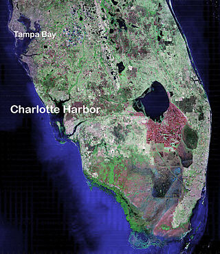
Charlotte Harbor Estuary, the second largest bay in Florida, is located on the Gulf of Mexico coast of west Florida with two thirds lying in Charlotte County, Florida and one in Lee County. The harbor's mouth is located behind Gasparilla Island, one of the many coastal barrier islands on the southwest coast of Florida, with access from the Gulf of Mexico through the Boca Grande Pass between Gasparilla Island on the north and Lacosta Island on the south. Charlotte Harbor covers about 270 sq mi (700 km2)

<span class="mw-page-title-main">Spanish missions in Florida</span> Catholic religious outposts

Beginning in the second half of the 16th century, the Kingdom of Spain established a number of missions throughout La Florida in order to convert the Native Americans to Roman Catholicism, to facilitate control of the area, and to obstruct regional colonization by other Protestants, particularly, those from England and France. Spanish Florida originally included much of what is now the Southeastern United States, although Spain never exercised long-term effective control over more than the northern part of what is now the State of Florida from present-day St. Augustine to the area around Tallahassee, southeastern Georgia, and some coastal settlements, such as Pensacola, Florida. A few short-lived missions were established in other locations, including Mission Santa Elena in present-day South Carolina, around the Florida peninsula, and in the interior of Georgia and Alabama.

Acuera was the name of both an indigenous town and a province or region in central Florida during the 16th and 17th centuries. The indigenous people of Acuera spoke a dialect of the Timucua language. In 1539 the town first encountered Europeans when it was raided by soldiers of Hernando de Soto's expedition. French colonists also knew this town during their brief tenure (1564–1565) in northern Florida.

<span class="mw-page-title-main">Timucua</span> Native American people

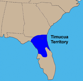
The Timucua were a Native American people who lived in Northeast and North Central Florida and southeast Georgia. They were the largest indigenous group in that area and consisted of about 35 chiefdoms, many leading thousands of people. The various groups of Timucua spoke several dialects of the Timucua language. At the time of European contact, Timucuan speakers occupied about 19,200 square miles (50,000 km2) in the present-day states of Florida and Georgia, with an estimated population of 200,000. Milanich notes that the population density calculated from those figures, 10.4 per square mile (4.0/km2) is close to the population densities calculated by other authors for the Bahamas and for Hispaniola at the time of first European contact. The territory occupied by Timucua speakers stretched from the Altamaha River and Cumberland Island in present-day Georgia as far south as Lake George in central Florida, and from the Atlantic Ocean west to the Aucilla River in the Florida Panhandle, though it reached the Gulf of Mexico at no more than a couple of points.

The indigenous peoples of Florida lived in what is now known as Florida for more than 12,000 years before the time of first contact with Europeans. However, the indigenous Floridians living east of the Apalachicola River had largely died out by the early 18th century. Some Apalachees migrated to Louisiana, where their descendants now live; some were taken to Cuba and Mexico by the Spanish in the 18th century, and a few may have been absorbed into the Seminole and Miccosukee tribes.

<span class="mw-page-title-main">Uzita (Florida)</span>

Uzita (Uçita) was the name of a 16th-century native chiefdom, its chief town and its chiefs. Part of the Safety Harbor culture, it was located in present-day Florida on the south side of Tampa Bay.

<span class="mw-page-title-main">Mocoso</span> 16th-century chiefdom in Florida

Mocoso was the name of a 16th-century chiefdom located on the east side of Tampa Bay, Florida near the mouth of the Alafia River, of its chief town and of its chief. Mocoso was also the name of a 17th-century village in the province of Acuera, a branch of the Timucua. The people of both villages are believed to have been speakers of the Timucua language.

<span class="mw-page-title-main">Safety Harbor culture</span> Archaeological culture practiced by Native Americans living on the central Gulf coast Florida

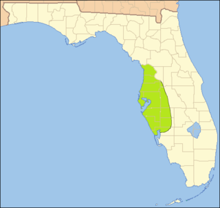
The Safety Harbor culture was an archaeological culture practiced by Native Americans living on the central Gulf coast of the Florida peninsula, from about 900 CE until after 1700. The Safety Harbor culture is defined by the presence of Safety Harbor ceramics in burial mounds. The culture is named after the Safety Harbor site, which is close to the center of the culture area. The Safety Harbor site is the probable location of the chief town of the Tocobaga, the best known of the groups practicing the Safety Harbor culture.

<span class="mw-page-title-main">Northern Utina</span> Extinct Native American people in Florida

The Northern Utina, also known as the Timucua or simply Utina, were a Timucua people of northern Florida. They lived north of the Santa Fe River and east of the Suwannee River, and spoke a dialect of the Timucua language known as "Timucua proper". They appear to have been closely associated with the Yustaga people, who lived on the other side of the Suwannee. The Northern Utina represented one of the most powerful tribal units in the region in the 16th and 17th centuries, and may have been organized as a loose chiefdom or confederation of smaller chiefdoms. The Fig Springs archaeological site may be the remains of their principal village, Ayacuto, and the later Spanish mission of San Martín de Timucua.

<span class="mw-page-title-main">Carlos (Calusa)</span> Paramount chief of the Calusa people

Carlos, also known as Calos or King Calusa, was king or paramount chief of the Calusa people of Southwest Florida from about 1556 until his death. As his father, the preceding king, was also known as Carlos, he is sometimes called Carlos II. Carlos ruled over one of the most powerful and prosperous chiefdoms in the region at the time, controlling the coastal areas of southwest Florida and wielding influence throughout the southern peninsula. Contemporary Europeans recognized him as the most powerful chief in Florida.

The Yustaga were a Timucua people of what is now northwestern Florida during the 16th and 17th centuries. The westernmost Timucua group, they lived between the Aucilla and Suwannee Rivers in the Florida Panhandle, just east of the Apalachee people. A dominant force in regional tribal politics, they may have been organized as a loose regional chiefdom consisting of up to eight smaller local chiefdoms.

Pohoy was a chiefdom on the shores of Tampa Bay in present-day Florida in the late sixteenth century and all of the seventeenth century. Following slave-taking raids by people from the Lower Towns of the Muscogee Confederacy at the beginning of the eighteenth century, the surviving Pohoy people lived in several locations in peninsular Florida. The Pohoy disappeared from historical accounts after 1739.

Ocale was the name of a town in Florida visited by the Hernando de Soto expedition, and of a putative chiefdom of the Timucua people. The town was probably close to the Withlacoochee River at the time of de Soto's visit, and may have later been moved to the Oklawaha River.

Urriparacoxi, or Paracoxi, was the chief of a Native American group in central Florida at the time of Hernando de Soto's expedition through what is now the southeastern United States. "Urriparacoxi" was a title, meaning "war leader". There is no known name for the people he led, or for their territory.

Juan Ortiz was a Spanish sailor who was held captive and enslaved by Native Americans in Florida for eleven years, from 1528 until he was rescued by the Hernando de Soto expedition in 1539. Two accounts of Ortiz's eleven years as a captive, differing in details, offer a story of Ortiz being sentenced to death by a Native American chief two or three times, saved each time by the intervention of a daughter of the chief, and finally escaping to a neighboring chiefdom, whose chief sheltered him.

The Amacanos were a native American people who lived in the vicinity of Apalachee Province in Spanish Florida during the 17th century. They are believed to have been related to, and spoken the same language as, the Chacato, Chine, Pacara and Pensacola peoples. The Amacano were served, together with other peoples, by a series of Spanish missions during the last quarter of the 17th century.

References