Related Research Articles
The Australian Geospatial-Intelligence Organisation (AGO) is an Australian government intelligence agency that is part of the Department of Defence responsible for the collection, analysis, and distribution of geospatial intelligence (GEOINT) in support of Australia's defence and national interests. The AGO is one of six agencies that form the Australian Intelligence Community.
The 45×90 points are the four points on Earth which are both halfway between one of the geographical poles and the equator, and halfway between the Prime Meridian and the 180th meridian. Both northern 45×90 points are located on land, while both southern 45×90 points are in remote open ocean locations.
THEOS, also known as Thaichote, is an Earth observation mission of Thailand, developed at EADS Astrium SAS, Toulouse, France. In July 2004, EADS Astrium SAS signed a contract for delivery of THEOS with GISTDA of Bangkok, Thailand. GISTDA is Thailand's leading national organization in the field of space activities and applications. The Thai Ministry of Science and Technology funds the program.
WSPR is an acronym for Weak Signal Propagation Reporter. It is a protocol, implemented in a computer program, used for weak-signal radio communication between amateur radio operators. The protocol was designed, and a program written initially, by Joe Taylor, K1JT. The software code is now open source and is developed by a small team. The program is designed for sending and receiving low-power transmissions to test propagation paths on the MF and HF bands.

Australian Border Force Cutter (ABFC) Ocean Shield is an offshore patrol vessel operated by the Australian Border Force. The ship was originally ordered in 2010 by DOF Subsea as an offshore support vessel, and was laid down by STX OSV as MSV Skandi Bergen in 2011. In 2012, the Australian Department of Defence was seeking a short-term replacement for the decommissioned Kanimbla-class amphibious landing ships, and negotiated to purchase the under-construction Skandi Bergen from DOF Subsea. The ship was completed, and entered Royal Australian Navy (RAN) service in mid-2012 as the civilian-crewed Australian Defence Vessel (ADV) Ocean Shield.

The following lists events from 2014 in Malaysia.

Malaysia Airlines Flight 370 (MH370/MAS370) was an international passenger flight operated by Malaysia Airlines that disappeared from radar on 8 March 2014, while flying from Kuala Lumpur International Airport in Malaysia to its planned destination, Beijing Capital International Airport in China. It has not been determined what caused its disappearance.

Flightradar24 is a Swedish Internet-based service that shows real-time aircraft flight tracking information on a map. It includes flight tracking information, origins and destinations, flight numbers, aircraft types, positions, altitudes, headings and speeds. It can also show time-lapse replays of previous tracks and historical flight data by airline, aircraft, aircraft type, area, or airport. It aggregates data from multiple sources, but, outside of the United States, mostly from crowdsourced information gathered by volunteers with ADS-B receivers and from satellite-based ADS-B receivers.
Malaysia Airlines Flight 370 disappeared on 8 March 2014, after departing from Kuala Lumpur for Beijing, with 227 passengers and 12 crew members on board. Malaysia's then Prime Minister, Najib Razak, stated that the aircraft's flight ended somewhere in the Indian Ocean, but no further explanation was given at the time. Despite searches finding debris considered with strong certainty to originate from the crash, official announcements were questioned by many critics, and several theories about the disappearance were proposed. Some of these were described as conspiracy theories.
The Joint Agency Coordination Centre (JACC) is an Australian government agency which was established on 30 March 2014 to coordinate search and recovery operations for Malaysia Airlines Flight 370, which disappeared on 8 March 2014 and was soon thereafter determined to have ended in the Southern Indian Ocean, within Australia's concurrent aeronautical and maritime search and rescue regions. The JACC is an agency within Australia's Department of Infrastructure and Regional Development, headed by Judith Zielke. It does not perform any search, recovery, or investigation activities, but coordinates the search effort and serves as a primary point of contact for information about the search for media and families of Flight 370 passengers.
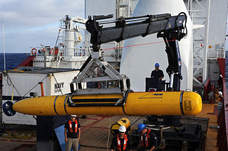
The Bluefin-21 is an autonomous underwater vehicle (AUV) developed by Bluefin Robotics for defence, commercial or scientific use. It found its most famous use in April 2014 in the search for the wreckage of the missing Malaysia Airlines Flight 370.
SciCast is a collaborative platform for science and technology forecasting created by George Mason University with the help of a grant from the Intelligence Advanced Research Projects Activity (IARPA) as part of its ForeST program. SciCast is currently on hiatus, after losing its main IARPA funding. It was expected to re-open in the fall of 2015 with the support of a major Science & Technology sponsor, but this had not occurred by January 2016.
A satellite data unit (SDU) is an avionics device installed in an aircraft that allows air/ground communication via a satellite network. It is an integral part of an aircraft's SATCOM system. The device connects with a satellite via ordinary radio frequency (RF) communication and the satellite then connects to a ground station or vice versa. All satellite communication whether audio or data is processed by the SDU.
The Boeing Uninterruptible Autopilot is a system designed to take control of a commercial aircraft away from the pilot or flight crew in the event of a hijacking.

The disappearance of Malaysia Airlines Flight 370, a scheduled international passenger flight from Kuala Lumpur International Airport to Beijing Capital International Airport on 8 March 2014, prompted a large, multinational search in Asia and the southern Indian Ocean that became the most expensive search in aviation history. Analysis of communications between the aircraft and Inmarsat by multiple agencies has concluded that the flight ended in the southern Indian Ocean.
The analysis of communications between Malaysia Airlines Flight 370 and Inmarsat's satellite telecommunication network provide the primary source of information about Flight 370's location and possible in-flight events after it disappeared from military radar coverage at 02:22 Malaysia Standard Time (MYT) on 8 March 2014, one hour after communication with air traffic control ended and the aircraft departed from its planned flight path while over the South China Sea.
The timeline of Malaysia Airlines Flight 370 lists events associated with the disappearance of Malaysia Airlines Flight 370—a scheduled, commercial flight operated by Malaysia Airlines from Kuala Lumpur International Airport to Beijing Capital International Airport on 8 March 2014 with 227 passengers and 12 crew. Air traffic control lost contact with Flight 370 less than an hour into the flight, after which it was tracked by military radar crossing the Malay Peninsula and was last located over the Andaman Sea. Analysis of automated communications between the aircraft and a satellite communications network has determined that the aircraft flew into the southern Indian Ocean, before communication ended shortly after 08:19 (UTC+8:00). The disappearance initiated a multi-national search effort that became the most expensive search in aviation history.

The MV Havila Harmony is a multi-role, dynamically-positioned support vessel built in 2005 for subsea construction and support operations. The vessel is owned by Havila Shipping and currently on long-term charter to Fugro.

MH370: The Plane That Disappeared is a British docuseries released on Netflix and directed by Louise Malkinson about the 2014 disappearance of Malaysia Airlines Flight 370.
References
- ↑ "tomnod (home page)". Tomnod. Archived from the original on 23 August 2014. Retrieved 14 April 2015.
The Tomnod mission is to utilize the power of crowdsourcing to identify objects and places in satellite images. We created this web app with thousands of volunteers (like you!) in mind.
- ↑ "Missing Malaysia Airlines Flight MH370: Millions of Users Crash Crowd-Sourcing Site Tomnod". International Business Times. 12 March 2014. Retrieved 16 March 2014.
- ↑ "Alumni Crowdsourcing Venture Acquired by Satellite Imaging Co". UC San Diego. Summer 2013. Retrieved 19 March 2014.
- 1 2 "Virtual search party for Malaysian plane back up and running". Fox News. 11 March 2014. Retrieved 16 March 2014.
- ↑ "Crowdsourcing search for Malaysian plane goes viral, but no luck so far". CNN. 13 March 2014. Retrieved 16 March 2014.
- 1 2 3 "Web collects 650K clues in satellite-image search for missing plane". CNET. 12 March 2014. Retrieved 16 March 2014.
- ↑ "Missing Malaysian jet: Satellite imagery provider invites public's help". LA Times . 11 March 2014. Retrieved 16 March 2014.
- 1 2 "Using crowdsourcing to search for flight MH 370 has both pluses and minuses". Quartz News. 12 March 2014. Retrieved 16 March 2014.
- ↑ "How the Search for Genghis Khan Helped the United Nations Map Refugees in Somalia". National Geographic. 23 July 2012. Archived from the original on 27 July 2012. Retrieved 16 March 2014.
- ↑ "Missing Airplane: Malaysia Airlines MH370 - help us tag!". tomnod.com. Retrieved 11 March 2014.
- 1 2 3 "Tomnod – the online search party looking for Malaysian Airlines flight MH370". The Guardian . 14 March 2014. Retrieved 15 March 2014.
- ↑ "Tomnod campaign to find missing Malaysian jet draws online crowds". San Jose Mercury News . 12 March 2014. Retrieved 15 March 2014.
- ↑ "Tomnod: How to join the virtual search party scanning satellite imagery for missing flight MH370". The Independent. 13 March 2014. Retrieved 16 March 2014.
- ↑ "Missing MH370: Online map site Tomnod expands search to Straits of Malacca, Indian Ocean". The Star. 16 March 2014. Retrieved 16 March 2014.