Related Research Articles

Stirling is a city in central Scotland, 26 miles (42 km) northeast of Glasgow and 37 miles (60 km) north-west of Edinburgh. The market town, surrounded by rich farmland, grew up connecting the royal citadel, the medieval old town with its merchants and tradesmen, the Old Bridge and the port. Located on the River Forth, Stirling is the administrative centre for the Stirling council area, and is traditionally the county town of Stirlingshire. Proverbially it is the strategically important "Gateway to the Highlands".

The University of Stirling (Scots: University o Stirlin, Scottish Gaelic: Oilthigh Shruighlea is a public university in Stirling, Scotland, founded by royal charter in 1967. It is located in the Central Belt of Scotland, built within the walled Airthrey Castle estate.

Alloa is a town in Clackmannanshire in the Central Lowlands of Scotland. It is on the north bank of the Forth at the spot where some say it ceases to be the River Forth and becomes the Firth of Forth. Alloa is south of the Ochil Hills, 5.5 miles (8.9 km) east of Stirling and 7.9 miles (12.7 km) north of Falkirk; by water Alloa is 25 miles (40 km) from Granton.

The Oval, currently known for sponsorship reasons as the Kia Oval, is an international cricket ground in Kennington, located in the borough of Lambeth, in south London. The Oval has been the home ground of Surrey County Cricket Club since it was opened in 1845. It was the first ground in England to host international Test cricket in September 1880. The final Test match of the English season is traditionally played there.

The Stirling council area is one of the 32 council areas of Scotland, and has a population of about 94,330. It was created in 1975 as a lower-tier district within the Central region. The district covered parts of the historic counties of Stirlingshire and Perthshire, which were abolished for local government purposes. In 1996 the Central region was abolished and Stirling Council took over all local government functions within the area.

Murrayfield is an affluent area to the west of Edinburgh city centre in Scotland. It is to the east of Corstorphine and north of Balgreen and Roseburn. The A8 road runs east–west through the south of the area. Murrayfield is often considered to include the smaller neighbouring areas of Ravelston and Roseburn.

Lothian Thistle Hutchison Vale Football Club (LTHV) are a senior non-league football club based in Edinburgh, Scotland. Currently competing in the East of Scotland League Premier Division, they play their home matches at Saughton Enclosure in the Saughton area of the city.

Staithes is a seaside village in North Yorkshire, England. Easington and Roxby Becks, two brooks that run into Staithes Beck, form the border between the unitary authorities of North Yorkshire and Redcar and Cleveland. The area located on the Redcar and Cleveland side is called Cowbar. Formerly one of the many fishing centres in England, Staithes is now largely a tourist destination within the North York Moors National Park.
Kingsbarns is a village and parish in Scotland lies near the eastern coast of Fife, in an area known as the East Neuk, 6.5 miles (10.5 km) southeast of St Andrews and 3.6 miles (5.8 km) north of Crail. The name derives from the area being the location of the barns used to store grain before being transported to the Palace at Falkland.

Carbrain /kar 'bren/ is a neighbourhood in Cumbernauld, North Lanarkshire in Scotland. It gets a brief mention on William Roy's eighteenth century map of the Scottish Lowlands. In the nineteenth century it was no more than a farm steading. An early map shows just a few buildings existed in 1864. By the start of the First World War it had not grown significantly, although there was a school near the railway station. It was sometimes spelled Carbrane. Even in 1956 Carbrain was mostly farmland with a small burn flowing through it. The map seems to show this flowing possibly down the Gully and eventually feeding the Red Burn in the Vault Glen. This burn isn't named so can't be identified with the Horseward Burn from historic maps.
Stirling High School is a state high school for 11- to 18-year-olds run by Stirling Council in Stirling, Scotland. It is one of seven high schools in the Stirling district, and has approximately 972 pupils. It is located on Torbrex Farm Road, near Torbrex Village in the suburbs of Stirling, previously being situated on the old volcanic rock where Stirling Castle lies and on Ogilvie Road.
Crossford is a splendid village in West Fife, Scotland. It is 1 mile west of Dunfermline, east of Cairneyhill, astride the A994, at 56°03′51″N03°29′47″W.

Dalmuir is an area nine miles northwest of Glasgow, Scotland, on the western side of Clydebank, and part of West Dunbartonshire Council Area. The name is a lowland Scots derivation of the Gaelic meaning Big Field. The area was originally two separate villages with Dalmuir Shore joining with Clydebank in 1886 and Dalmuir Village in 1906, during a period of rapid industrialization and expansion. Dalmuir is bounded by the village of Old Kilpatrick to the west, the Mountblow and Parkhall housing schemes to the north, and the Clydebank town centre area to the east. To the south is the River Clyde.
Parkhead Football Club was a Scottish football club from the Parkhead district of Glasgow who played in Scottish Junior Football Association competitions from their formation in 1880 until going out of business in 1963. Originally playing at The Sheddens on Old Shettleston Road, the club moved to Helenslea Park near current day Beattock/Sorby Streets in 1892 before development forced the club further out towards the Newbank/Lilybank area and into New Helenslea Park. In the early years of the Scottish Junior Cup, Parkhead appeared in nine finals and won the cup five times. The club supplied eight players who went on to become full Scotland internationals later in their careers and Andy Auld who played five times for the US national team.

Firs Park was a football stadium in Falkirk, Scotland, which was the home of East Stirlingshire F.C. between 1921 and 2008. It was located on Firs Street, 0.3 miles north-east of the town centre. At the time of closing the ground had a capacity of 1,800 with 200 seated.

Kelty Hearts Football Club is a football club based in the village of Kelty in Fife, Scotland. Formed in 1975 and nicknamed the Hearts, the Maroon Machine and the Jambos, they play their home games at New Central Park. Their home colours are maroon shirts, white shorts and maroon socks, while their away colours are typically all blue.
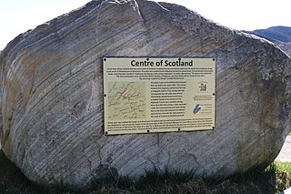
There is some debate as to the location of the geographical centre of Scotland. This is due to different methods of calculating the centre, and whether surrounding islands are included.
Forthill is a cricket ground in Broughty Ferry, Dundee, Scotland. It has been used for cricket since, at the latest, 1884, when Forfarshire played Aberdeenshire there. Scotland first used the ground in 1913 when they played Northamptonshire.
New Williamfield No. 1 Oval is a cricket ground in Stirling, Scotland. The ground is owned and used by Stirling County Cricket Club.
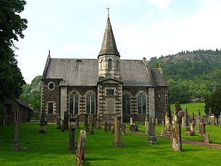
Logie Kirk is an isolated but operational church east of Stirling in central Scotland serving Church of Scotland pastoral duties in the areas of Cambuskenneth, Bridge of Allan, Causewayhead, and formerly the estate of Airthrey Castle.
References
- ↑ "Google Maps". Google Maps. Retrieved 11 December 2017.
- ↑ McNeill, Alastair (1 November 2017). "Stirling's oldest resident revealed to be 4000-year-old 'Torbrex Tam'". Dailyrecord.co.uk. Retrieved 11 December 2017.
- ↑ "Stirling County Cricket Club - Home Page". www.stirlingcountycc.co.uk. Retrieved 11 December 2017.
- ↑ Aitken, Fiona. "History". www.stirlingcountycc.co.uk. Retrieved 11 December 2017.
- ↑ "Inn at Torbrex :: Home". torbrexinn.co.uk.
- ↑ "New lease of life for historic coaching inn - Scottish Licensed Trade News". sltn.co.uk.
Coordinates: 56°06′24″N3°57′08″W / 56.106789°N 3.952350°W
| | This Scotland-related article is a stub. You can help Wikipedia by expanding it. |